The main purpose of this ongoing blog will be to track planetary extreme, or record temperatures related to climate change. Any reports I see of ETs will be listed below the main topic of the day. I’ll refer to extreme temperatures as ETs (not extraterrestrials).😉
Main Topic: A Warm End to 2024 Leads to Severe Storm Outbreak Across the South
Dear Diary. Yesterday we looked forward into January, noting that the coming month would be quite frigid east of the Rockies, so much so that for the first time since March 2023 we could see a below average month for temperatures across the lower 48 states. Today we see that 2024 is ending on a warm note that will cement the year as the first or second warmest year on record next to 2012 by our estimation for the same area.
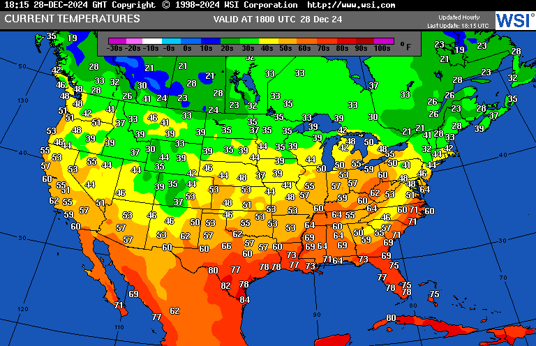
These afternoon temperatures from Saturday are definitely not very December like:

Usually by late December we at least see some below zero readings on this chart from Canada southward into the northern Plains, but there are none to be had on the above chart.
Unseasonable warmth across the South is fueling a severe weather outbreak this weekend. I caution that historically these have occurred across the South during winter, but due to climate change these events are happening this time of the year with more regularity. Here are snapshots of what is occurring there this afternoon:
Here are more details on this severe weather outbreak from Matthew Cappucci writing for the Washington Post:
https://www.washingtonpost.com/weather/2024/12/27/texas-tornado-risk-deep-south-southeast
Tornadoes hit parts of Texas — and more storms may be on the way
The Storm Prediction Center is cautioning about the risk of “strong tornadoes” on Saturday.
December 27, 2024

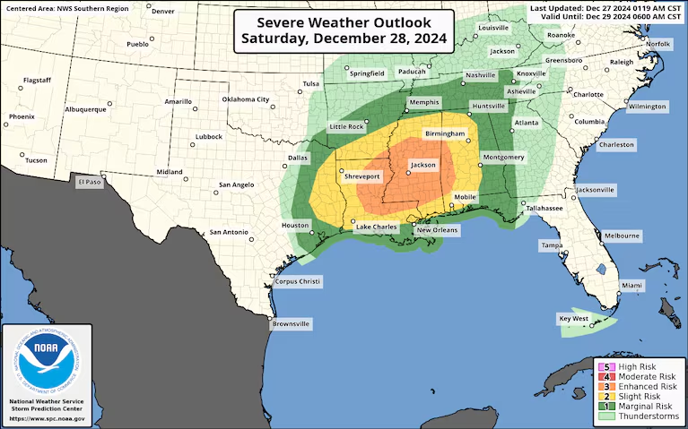
The Storm Prediction Center’s outlook for severe weather potential on Saturday. (NOAA/SPC)

A spattering of tornadoes tore through parts of Southeast Texas — and more severe weather is on the way this weekend. The National Weather Service is warning that significant tornadoes are possible Saturday across the Deep South, with additional severe weather Sunday in the Southeast.
A tall, highly visible tornado swirled through fields near El Campo, Texas, late Thursday about midway between Houston and Victoria. Another twister touched down near Atascocita in Harris County, then moved over Lake Houston. The same storm spawned a tornado to the east near Dayton, Texas, which was intercepted at close range by meteorologist Reed Timmer on a live stream. Two other brief tornado touchdowns were reported in Louisiana.
Now another low pressure system is about to bring clashing air masses and brew more storms, with an increasing threat Saturday. The weather service is warning of tornadoes that could be EF2 or greater strength on the Enhanced Fujita scale of intensity.
Severe weather activity tends to be greatest in the spring months, especially March through May, but it’s not unheard-of in the wintertime. During December and January, severe weather is most prevalent near the Gulf Coast, where warm waters provide instability, or thunderstorm fuel.
What to know about Saturday’s storms

A high-resolution model simulation of storms over the Deep South on Saturday. (WeatherBell)
Risk area: A Level 3 out of 5 enhanced risk of severe weather has been issued by the Storm Prediction Center around eastern Louisiana and Mississippi. It includes Jackson, Hattiesburg and Meridian in Mississippi, and Monroe and Alexandria in Louisiana. A Level 2 spans from East Texas to Birmingham, Alabama, and just touches Mobile, Alabama as well as New Orleans.
Hazards: The National Weather Service Storm Prediction Center writes that “large hail, damaging winds, and tornadoes are likely, potentially including a few strong (EF2+) tornadoes.”
Timing: Multiple rounds of severe weather are possible. The first will work northeast across Louisiana and southern Mississippi during the late morning into early afternoon, with storms intensifying by 1 or 2 p.m. and tornado risk increasing around then. Those storms will eventually move into Alabama by evening as a second line of storms forms to the west along the cold front in Louisiana.
The conditions: A pocket of high altitude cold air, low pressure and spin, known as a shortwave, is diving southeast out of the Four Corners region into Texas. Ahead of it, air will rise and form thunderstorms. The shortwave is affecting jet stream, causing changing winds with height. Tall storms will be affected by those changing winds and can rotate, hence the tornado threat.

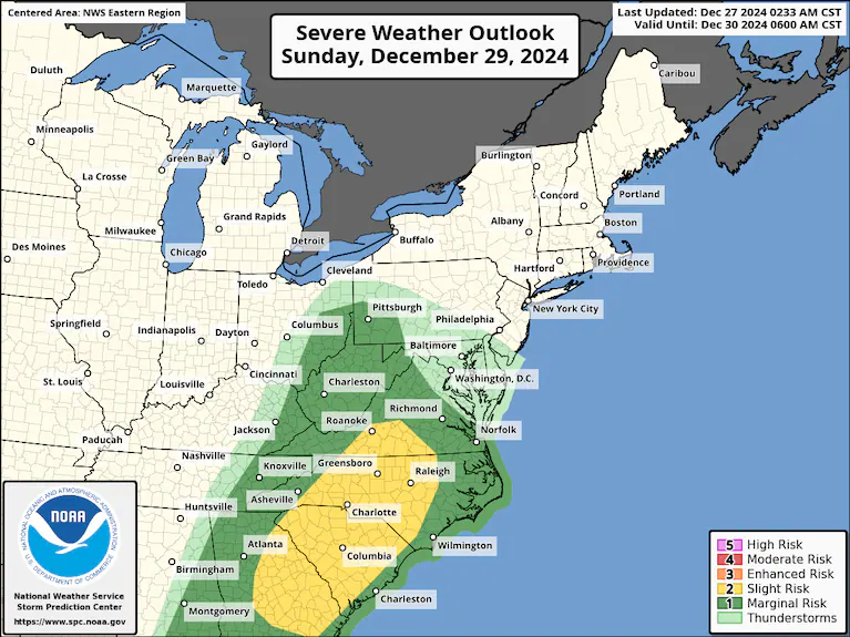
The Storm Prediction Center’s severe weather outlook for Sunday. (NOAA/SPC)
What to know about Sunday’s storms
Risk area: A Level 2 out of 5 severe risk stretches from Roanoke, south toward central Georgia, and includes the Carolina Piedmont. Charlotte, Raleigh, Greensboro, Durham and Winston-Salem are also in the zone.
Hazards: The main concern will be damaging straight-line gusts up to 60 mph. An isolated tornado can’t be ruled out.
Timing: Downpours and a few thunderstorms will probably be ongoing to start the day. Thunderstorms will intensify into the early afternoon and may evolve into lines, clusters or perhaps transient rotating supercells.

By Matthew Cappucci Matthew Cappucci is a meteorologist for Capital Weather Gang. He earned a B.A. in atmospheric sciences from Harvard University in 2019, and has contributed to The Washington Post since he was 18. He is an avid storm chaser and adventurer, and covers all types of weather, climate science, and astronomy. follow on X@MatthewCappucci
Here are more “ETs” recorded from around the planet the last couple of days, their consequences, and some extreme temperature outlooks, as well as any extreme precipitation reports:
Here is More Climate News from Saturday:
(As usual, this will be a fluid post in which more information gets added during the day as it crosses my radar, crediting all who have put it on-line. Items will be archived on this site for posterity. In most instances click on the pictures of each tweet to see each article. The most noteworthy items will be listed first.)