The main purpose of this ongoing blog will be to track global extreme or record temperatures related to climate change. Any reports I see of ETs will be listed below the main topic of the day. I’ll refer to extreme or record temperatures as ETs (not extraterrestrials).😉
Main Topic: Super Unusual Snow Occurred Across the Gulf Coast, But Was It Related e to Climate Change?
Dear Diary. Have any of you seen the film the Day After Tomorrow? The 2004 flick was made in response to climate change that became a big news item in the early 2000s. In it practically all of the Northern Hemisphere southward into Mexico froze over due to the jet stream changing in response to our greenhouse gas pollution. Of course, we know that it will only get warmer instead of colder in time except perhaps in Europe that could get frigid if and when the Atlantic meridional overturning current breaks down. Residents along the Gulf Coast woke up today to a Day After Tomorrow winter wonderland where some snow amounts were at all-time records, even breaking records from the 1890s during much colder times. The kid in me is delighted because children may be sledding in a once in a lifetime event where palm trees grow. Of course, adults will have headaches trying to dig out of the white stuff if they are not patient enough to wait for it to melt.
So, what happened? Climate change naysayers are laughing at scientists who purport that global warming is a big deal, pointing to this major snow and frigid event. But can they? While setting several hundred daily records mainly from stations with fairly short histories of logging climatological information, “Cold Wave Chione,” as I have dubbed it, was not all that historic because relatively few monthly records and all-time records were set from the system. Still, despite climate change, the atmosphere was still able to spit out a snowstorm for points unusually far to the south:
I along with Dr. Jennifer Francis contend that the initial stages of climate change will cause high amplifications with the jet stream as warm pockets move north towards the Arctic driving cold pockets to the south affecting…you guessed it…the polar vortex.
Here are more details from Yale Climate Communications:
A high-impact week, from a snowy Gulf Coast to shrieking California winds
The nationwide cold spell isn’t a record-smasher, but the Southwest drought and Gulf Coast snows are another matter.


by Bob Henson and Jeff Masters January 21, 2025
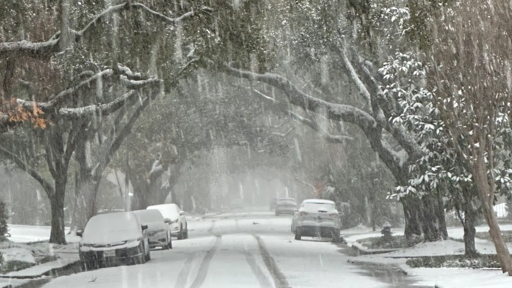
Heavy snow plasters a canopy of live oak trees in central Houston on Tuesday, January 21, 2025. (Image credit: Alan Foster.)
The weather pattern that’s dominated the United States for most of January jumped into overdrive this week. Nearly all of the 48 contiguous states are unusually cold, though it’s a pale imitation of the colossal, nationwide Arctic intrusions of decades past. In our warming climate, such 20th-century cold outbreaks may become increasingly tougher to match.
Yet winter can still pack a dangerous punch, as folks on the Gulf Coast and in California are finding in two very different ways. Historic, city-snarling snowfall – in some cases, possibly the heaviest in more than a century – was spreading on Tuesday into coastal communities from Texas toward Florida. Locations expecting snow include Galveston, Texas; New Orleans, Louisiana; Mobile, Alabama; and Pensacola, Florida.
Meanwhile, high winds, bone-dry air, and tinder-dry vegetation continue to plague coastal Southern California, just weeks after the area was hit by one of the most catastrophic fire events in modern U.S. history.
A rare taste of winter snowfall along the Gulf Coast
People along the immediate Gulf Coast occasionally get snowflakes mixed with cold rain, and sometimes even an inch or two of quick-melting snowfall. This week is bringing something different – the kind of snow more familiar to Midwesterners than Gulf Coast denizens. A sharp wave is rounding the bottom of a massive upper low extending from eastern Canada across the eastern U.S., and that will spawn a band of snow extending along and near the coast from west to east from Tuesday into Wednesday.
Ironically, one thing that’s helping to make the Gulf Coast setup so unusually snow-favorable is dry air. About a mile above sea level, some of the driest air on record was flowing across the South toward the Gulf of Mexico. When the atmosphere is forced upward in a storm system, temperatures drop until the air is saturated (i.e., relative humidity hits 100 percent). Along the Gulf Coast, the ample moisture supply from the Gulf of Mexico often yields saturation at temps above freezing – enough to put the brakes on snow formation.
On Tuesday, the air aloft was saturating at temps just below freezing, allowing for a rare all-snow temperature profile (see Fig. 1 below), including at some places more accustomed to sleet, freezing rain, or snow mixed with rain when winter weather does occur. A NOAA website shows how the atmospheric structure can vary for each of these.

Fig. 1: How to make a Gulf Coast snowstorm. The atmosphere was primed to create snow along the upper Gulf Coast on Tuesday morning, January 21, 2025, as the lowest mile or so of the atmosphere was just below freezing and nearly saturated with moisture. Left: Prototypical atmospheric profile (sounding) showing temperature (red line) and dew point (blue line) with height (shown on left in millibars or hectopascals; 850 mb is about one mile above sea level). When the blue and red lines are close, relative humidity is at or near 100%. As the air is forced upward within a winter storm, the atmosphere cools until it’s saturated. Even a shallow layer above freezing can lead to sleet or freezing rain instead of snow. Right: Atmospheric profile observed by radiosonde (weather balloon) launched from Lafayette, Louisiana, at 7 a.m. CST Tuesday, January 21. (Left image credit: NOAA; right image credit: Annotated from NCAR Real-Time Weather Data)
Below is a sampling of Gulf Coast cities that could end up with their heaviest snowfall in decades, along with the official National Weather Service forecasts as of Tuesday morning, January 21. As the numbers show, the event to beat is the jaw-dropping storm of February 1895 (see the recaps from Space City Weather and wunderground.com). Note that changes in the official observing sites (especially in the Houston area) can affect such records since the near-coastal region is prone to wide snow variations across small areas. Totals are also measured more often during modern snowstorms than the former once-a-day standard, and this can lead to higher totals than would have been recorded long ago.
Houston, TX
20.0” Feb 14-15, 1895
3.0” Feb 12, 1960
3.0” Jan 22, 1940
2.6” Jan 30, 1949
2.5” Dec 21-22, 1929
2.0” Jan 11, 1973
Forecast as of Tuesday morning, Jan 21: 3”-5”
Galveston, TX
15.4” Feb 14-15, 1895
6.0” Jan 12, 1886
4.0” Dec 24-25, 2004
2.5” Jan 11, 1973
2.2” Feb 12-13, 1960
Forecast as of Tuesday morning, Jan 21: 3”-5”
Tallahassee, FL
2.8” Feb 12-13, 1958
1.0” Dec 22-23, 1989
0.4” Feb 10, 1973
0.4” Mar 28, 1955
0.2” Feb 2, 1951
Forecast as of Tuesday morning, Jan 21: 2” (including snow, freezing rain, and/or sleet)
On top of these impressive amounts, which could have major local impacts, enough cold will stick around for a day or two to help preserve the snowpack – and the snow itself may help temperatures to plummet to record lows once the skies clear.
Most of the rest of the United States won’t see much if any record cold, even with this week’s Arctic plunge. Although January has been colder than average for most parts of the contiguous U.S., the chill is noteworthy more for its persistence and expansiveness than its sheer bite. In fact, as of Monday, January 20, the nation had seen many more record daily highs than record daily lows for the month thus far (thanks in large part to relatively balmy temperatures in parts of Florida and Alaska). This is a far cry from truly historic cold outbreaks such as those in December 1983, February 1989, and December 1990, all of which pulverized many hundreds of daily records across the central and eastern United States.
So is climate change having any influence on the much-publicized polar vortex episodes of recent years? That’s been a topic of research and debate for more than a decade, especially with disastrous episodes like the 2021 Texas cold wave interspersed amid an overall warming of U.S. winters, and the research continues to evolve. We’ll take a fresh dive into the topic in a forthcoming post.
Fierce winds and unprecedented winter dryness keeps Southern California on edge
Yet another round of powerful Santa Ana winds was cascading through the coastal mountains of Southern California from late Monday into Tuesday. The winds warmed and dried as they flowed downslope toward the coast, sending relative humidity well below 10 percent and pushing fire weather into the top-end “extremely critical” category once again. The peak wind gust observed so far during the event was 88 mph at Magic Mountain Truck Trail (located about 20 miles north of Los Angeles) at 9:50 am PST Jan. 20. Sandberg, California (located about 65 mi NW of Los Angeles) had sustained winds of 48 mph, gusting to 74 mph, with a relative humidity of 11%, at 1:51 pm Jan. 20. The station stopped sending data thereafter, likely because the high winds damaged the station or its communications infrastructure.
The strong winds fanned multiple fires overnight, but quick action by firefighters served to squelch them before serious impacts occurred. The largest new fire, called the Lilac Fire, was located in San Diego County, and was 80 acres with 10% containment at 10 a.m. EST Jan. 21, according to Cal Fire. There were evacuation orders in place for the fire, but there were no reports of large numbers of buildings being torched.
Strong Santa Ana winds are a normal part of the region’s winter climate. This month, the winds have been unusually frequent, and their power has been exacerbated at times by mountain-wave effects. These occur when strong winds blow nearly perpendicular to a mountain range and are joined by a temperature structure that allows energy to be trapped in a shallow layer and then forced to the ground well downstream. The winds on January 7-8 responsible for the catastrophic Eaton and Palisades fires near Los Angeles had strong mountain-wave components as well as a more north-to-south trajectory than usual, and that helped push the fires unusually far south into residential areas that hadn’t burned in modern times.
What’s been stoking the fire hazard isn’t just the sheer strength of the winds. It’s also that the winds are coinciding with parched conditions more typical of late summer and beyond anything on record for late January, a time when the winter wet season is typically nearing its peak. These intersections between the tail end of warm-season dryness and the front end of cold-season winds are becoming more of a threat as the rainy season contracts in our warming climate, a trend expected to continue.
As of Tuesday, January 21, downtown Los Angeles (data since 1878) and San Diego (data since 1851) had each received a mere 0.16 inches of rain since July 1. That’s unprecedented for San Diego, where the next-driest such period was 0.35 inches in 1962-63. In Los Angeles, the dryness is now in a tie with 1962-63, but another 0.40 inches of rain fell just before the end of January 1963. Every wet season on record in L.A. and San Diego has had at least 1.57 inches of rain by the end of February.
There’s finally a chance of rain in the Los Angeles and San Diego forecast this weekend, as the nation-straddling jet stream is projected to carve out a track off the Pacific coast before circling back eastward. The European ensemble model has been suggesting that as much as a half-inch could fall near San Diego, with an inch or more possible in the nearby mountains and lesser amounts toward Los Angeles. The GFS ensemble has been less enthusiastic, projecting amounts less than a half-inch almost everywhere. Only a slight change in the jet trajectory could make the pattern windy and dry instead of wet.
In any event, it’ll take far more rain than predicted to bring the region anywhere close to normal values for the wet season, which typically starts winding down by late March.
More like this:

Indirect death toll from the L.A. fires may end up in the thousands

Nobody’s insurance rates are safe from climate change

Earth roasts through its second consecutive hottest year on record
Bob Henson
Bob Henson is a meteorologist and journalist based in Boulder, Colorado. He has written on weather and climate for the National Center for Atmospheric Research, Weather Underground, and many freelance… More by Bob Henson
Jeff Masters
Jeff Masters, Ph.D., worked as a hurricane scientist with the NOAA Hurricane Hunters from 1986-1990. After a near-fatal flight into category 5 Hurricane Hugo, he left the Hurricane Hunters to pursue a… More by Jeff Masters
Jeff Master’s and Bob Henson’s “A high-impact week, from a snowy Gulf Coast to shrieking California winds” was first published on Yale Climate Connections, a program of the Yale School of the Environment, available at: http://yaleclimateconnections.org. This work is licensed under a Creative Commons Attribution-Noncommercial-No Derivative Works 2.5 license (CC BY-NC-ND 2.5).
Here are more “ETs” recorded from around the planet the last couple of days, their consequences, and some extreme temperature outlooks, as well as any extreme precipitation reports:
Here is More Climate News from Wednesday:
(As usual, this will be a fluid post in which more information gets added during the day as it crosses my radar, crediting all who have put it on-line. Items will be archived on this site for posterity. In most instances click on the pictures of each tweet to see each article. The most noteworthy items will be listed first.)