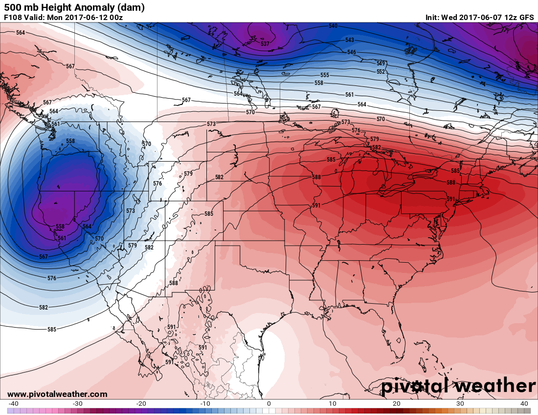
Dear diary, the weather pattern is shifting for the second week of June such that there will be some prolonged heat from the Midwest into the Northeast and Mid-Atlantic. As noted from my first diary log for this summer, the 500 Mb anomaly charts point to where high heat may occur during the summer. The redder the colors on the charts, the higher the 500 Mb heights will be above average on the Pivotal Weather charts that I will be presenting this season. The reddest zone for the second week of June will occur from the Great Lakes eastward into the Northeast as noted by this chart valid for Sunday evening the 11th:
Another good method for predicting heat or colder than average conditions is using weather model’s two meter temperature forecasts. Two meter temperature forecasts are very close to surface conditions. This chart is also valid on Sunday:
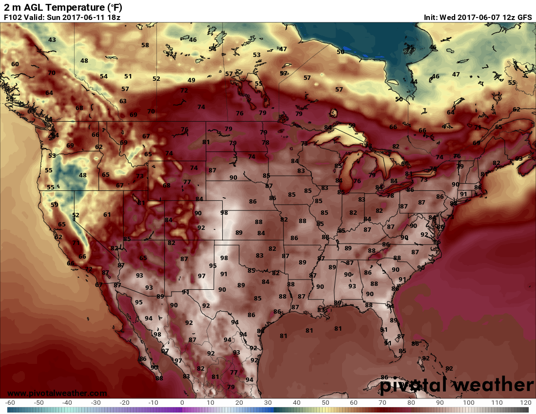
Usually the forecast two meter temps are a tad conservative, so during certain patterns, such as an offshore, westerly flow in the Northeast south of a front, adding two-five degrees is a good method to come up with ballpark figures. We should see low to mid 90’s from New England southward through Virginia early next week at many locations. There may be some record setting heat. I will add some addendum’s to this post reporting any records. There might be some record cool conditions also in association with the upper low, which will envelop the West.
The European model depicts the isobaric pattern, which will lead to hot weather across the Northeast. A front parked in Canada north of the jet stream will not bring relief to much of the area at least through the middle of next week:
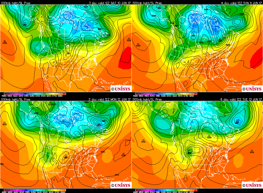
Looking at model data I doubt that we will see widespread “historic heat”. I will add to this post through the 14th, though, since there should be some newsworthy reports even if we do not see a tremendous number of records.
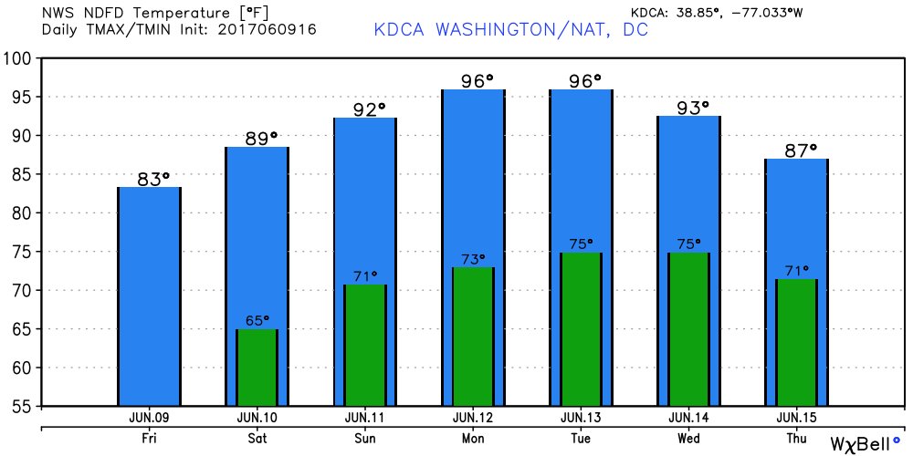
June 9th…Dear diary. I saw this message from Ryan Maue today:
“A pair of 96F for Mon-Tues in Washington D.C. as a 4-day heat wave begins on Sunday. 10-12°F above normal(84°F)” pic.twitter.com/7d0diSxAdN
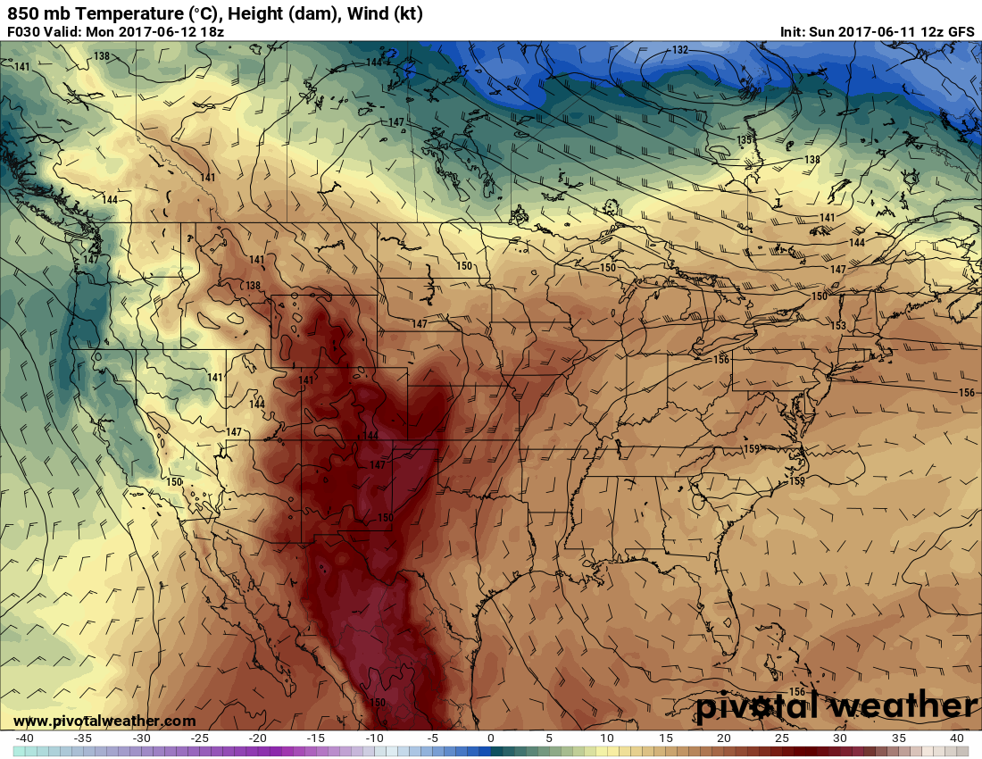
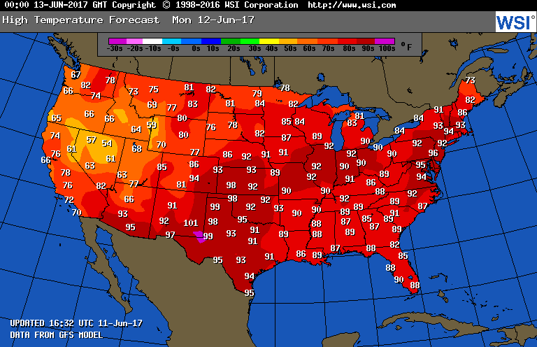
Upon close inspection the highest 850 Mb temperatures will be in a broad area east of the Rockies from Nebraska and Iowa eastward through Michigan into Virginia and all of the Northeast. One rule of thumb I had as a temperature forecaster was that east of the Rockies 850 Mb temps needed to be at least +18C for maxes to get near 90F during the summer. If you closely compare the 850 Mb chart I presented with this GFS temp maximum chart from Intellicast , that rule of thumb generally holds. Also note the area of near +30C in the Texas Panhandle. When temperatures are that warm at 850 Mb maxes usually reach near 100F at the surface. (Also note the relatively cooler 80’s forecast in the Southeast where 850 Mb temps should fail to reach +18F.):
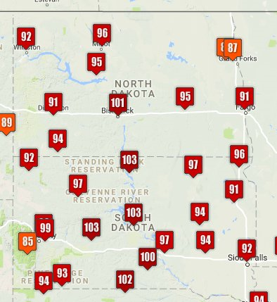
What happened today on Sunday? I saw this eye opening caption from @wcaxweather:

In any case it will be a scorcher across much of the nation on Monday. Stay cool. I hope that the ice cream truck won’t melt.😉

(Image from Mark Tarello)
Monday June 12th…Dear diary. The well advertised heat wave is well underway in the Northeast. It was a scorcher today in New York City, for example:
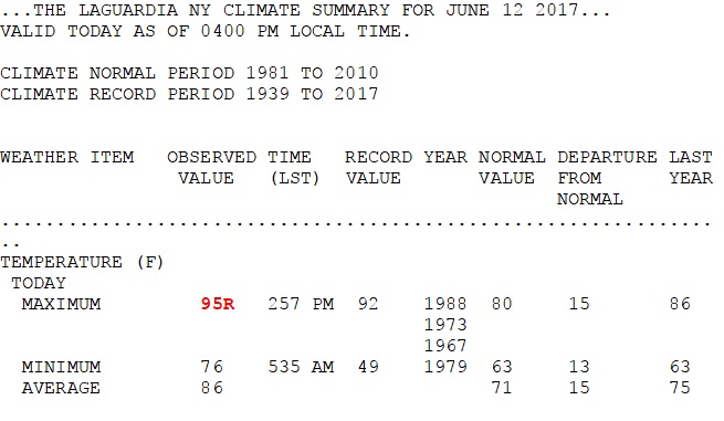
The entire Northeast corridor had record or near record temperatures today. Minimums tonight won’t drop much below 80 tonight in Megalopolis areas, so the heat is becoming dangerous. What about tomorrow? Here is the max chart for Tuesday the 13th off of the GFS model:

There will be no rest for the heat weary across much of the nation on Tuesday.
Meteorology models and ensembles are forecasting the heat to relax across the Northeast due to a back door front, but the heat will build in the West after mid-week. Note the orange and red anomalies in the West by the 20th on this Penn State image:
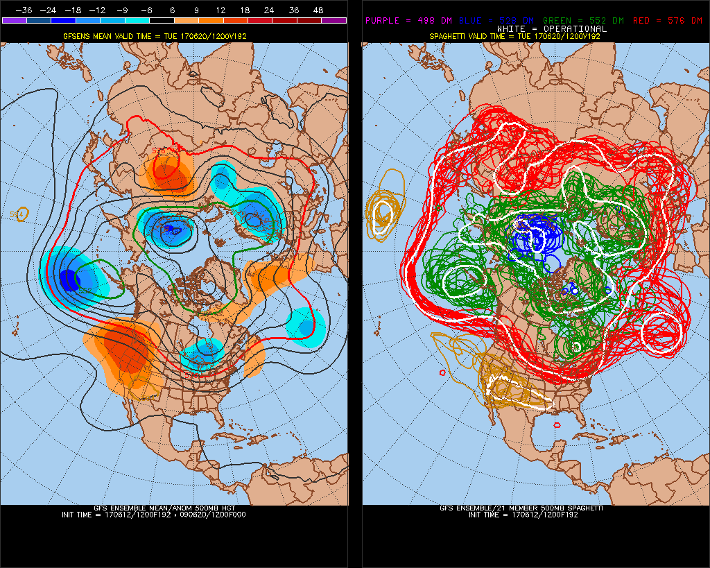
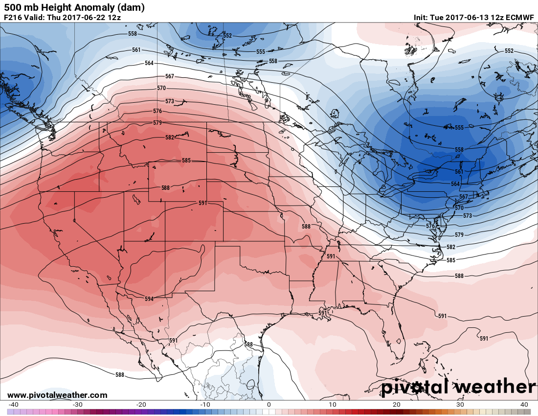
Anytime I see 500 Mb heights over 594 decameters, as forecast by the models, you can bet that there will be some searing summer heat.
Well before the 20th it will be getting hot in the Desert Southwest this week. Check out the forecast from the NWS for Phoenix:
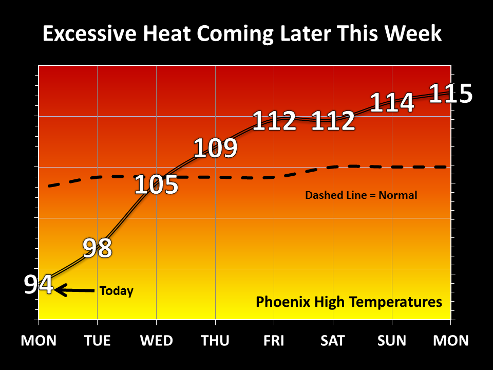
Dear diary. Each time I make an entry the enhanced heat wave situation due to carbon pollution seems to be getting worse.
_________________________________________________
Tuesday June 13th…Dear diary. The heat wave in the Northeast has certainly lived up to its billing. Yesterday June 12th the following major cities, as compiled by Jeff Masters of Weather Underground, set or tied records:
Atlantic City, New Jersey, 94°
Allentown, Pennsylvania, 92° (tied)
Harrisburg, Pennsylvania, 92° (tied)
Lansing, Michigan, 95° (tied)
Worcester, Massachusetts, 90° (tied)
Providence, Rhode Island, 95°
New York City, 93° (tied)
Newark, New Jersey, 97°
Cleveland, Ohio, 93°, (tied)
Albany, New York, 95°
Washington D.C., 95° (tied)
Bridgeport, Connecticut, 93°
Dr. Masters has also been emphasizing that high heat goes hand in hand with air pollution, another killer. As the planet’s temperature rises due to carbon pollution, so too will inversions trapping polluted air. Quoting Dr. Masters from his blog, “Approximately 12,000 of these premature U.S. air pollution deaths each year are from high ozone. Since this week’s high ozone levels are affecting a very large population of tens of millions of people, I expect that the death toll from ozone air pollution this week will be several hundred people.”
Dr. Masters’ post can be found here: https://www.wunderground.com/cat6/record-heat-brings-first-serious-air-pollution-episode-2017-northeast-midwest
This NOAA list of big city records from today is very impressive:
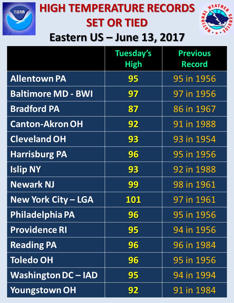
The following record is my hot big city record pick for today that was in the list:

The Philadelphia record was broken after 61 years. As promised yesterday, a back door front will bring relief to all of the Northeast Wednesday. Let’s take a look at tomorrow’s highs from the GFS model:
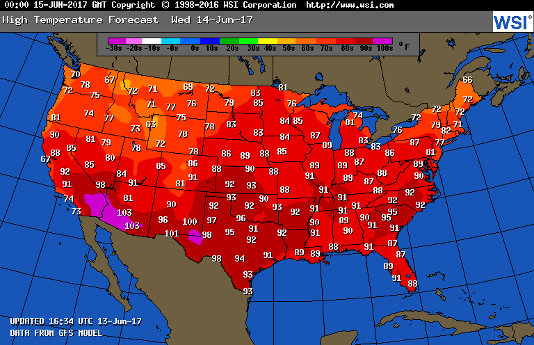
Only Washington D.C. will be flirting with 90. I would expect that most locations will be below record values on Wednesday, but heat will begin to build in the Desert Southwest.
I did notice an ominous trend in the medium range models the last couple of days on model ensembles, which I will now relate. In about 10 days the upper ridge strengthening over the Southwest could expand into the Plains and slowly move east in response to systems moving towards the West Coast. If this scenario happens near record heat will develop from the Rockies through much of the Plains and South. This is the forecast by the European model, the most reliable meteorology model, valid on Thursday June 22nd:
That’s it for this evening.
To see all 2017 Heat Diary entries click:
https://guyonclimate.com/category/heatdiary2017/
The Climate Guy