Monday evening July 10th updates…
Here are today’s maxes for major reporting stations:

The century+ readings that occurred in South Dakota and Nebraska yesterday moved south into Kansas today. I have not seen reports of records, but a few may come from California, which continues to swelter.
How about another quick meteorology lesson? We can compare today’s maxes with 850Mb temperatures to get an idea of how hot it needs to be at that level to get what verified at the surface:
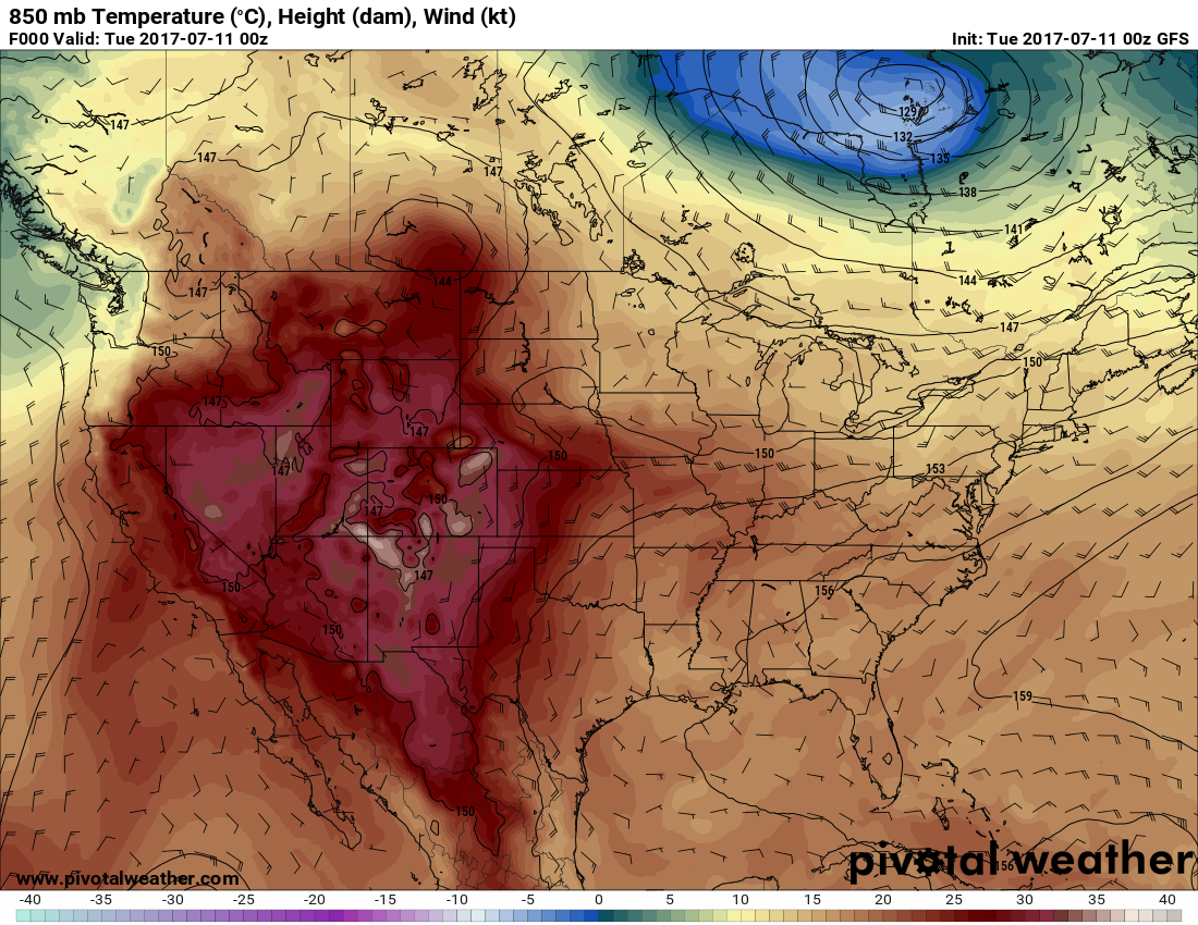
For example, the stripe of bright reds on the Pivotal chart from Kansas to St. Louis corresponds with higher surface maxes than surrounding areas. Another area of 100’s in northeast Montana and western North Dakota corresponds to higher 850 Mb temperatures there… about +24-25 centigrade. Meteorologists often use 850 Mb charts to forecast maxes and minimums.
The Climate Guy
Monday July 10th…
Dear diary. Let’s step back for a minute and discuss and define more meteorological science. On this blog I have been constantly referring to “ridges” of high pressure aloft, which can lead to heat waves during the summer. These are actually heat domes which are controlled by Rossby waves and jet stream configurations. I promise… no equations here😊, but for those of you wanting to delve into the latest climate science with heat wave ramifications, please see Dr. Michael Mann’s research from 2017: https://insideclimatenews.org/news/27032017/climate-change-global-warming-extreme-weather-jet-stream-michael-mann-penn-state
Researchers for decades have been feverishly working on better meteorological models involving factors, such as Rossby waves, to get better forecasts further out in time. In prior posts on the Heat Diary I have mentioned that the state of meteorology science is such that models can’t be relied on to predict the positions and strength of short wave features let alone most long wave features past about 240 hours out. An example of a short wave feature would be a hurricane. A long wave feature would be a large heat wave dome like the ones that have affected the West lately. I will refer to any model from now on valid more than 240 hours out as a “fantasy” model… something intriguing to look at but likely not to verify.
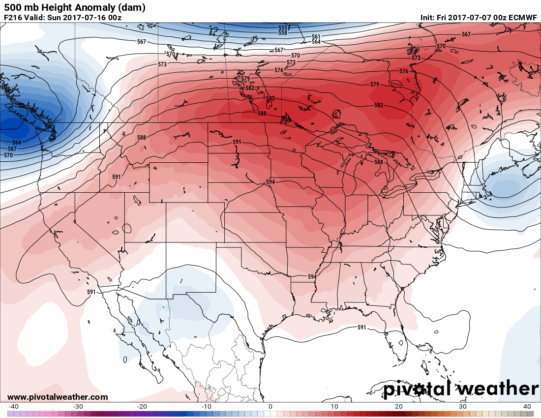
Before going to sleep last night I got a chuckle out of the “fantasy” model panels from the 00Z Monday run of the GFS. This model run forecast perhaps a worst case scenario during late July of a hurricane strafing Florida and Louisiana while a record breaking, monstrous heat wave, denoted by the 594 decameter height line, grips the nation from coast to coast:
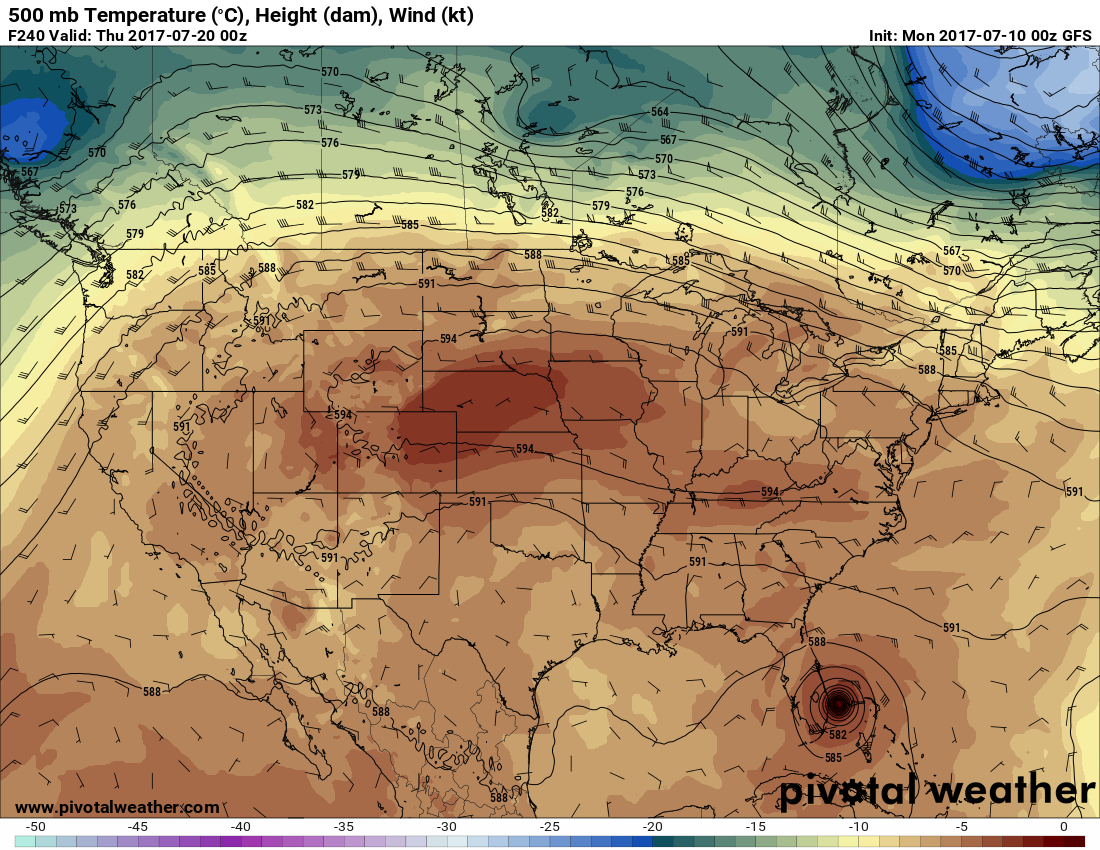
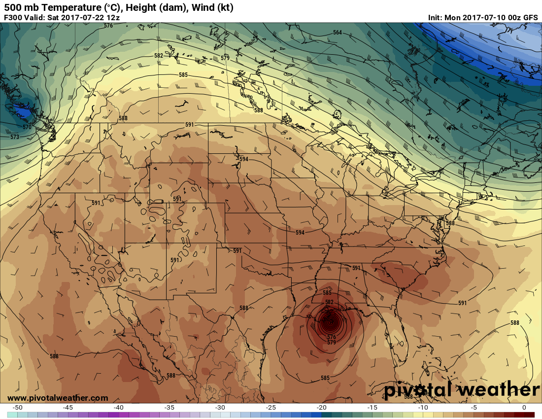
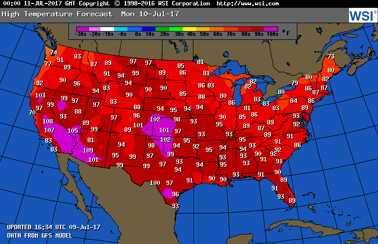
O.K. let’s come back down to Earth and read the shorter range model tea leaves, which are much more reliable. As forecast, the heat wave in the West will be undergoing moderation the next couple of days, while a warming trend will continue east of the Rockies ahead of a front. Here are Tuesday’s maxes from the GFS:
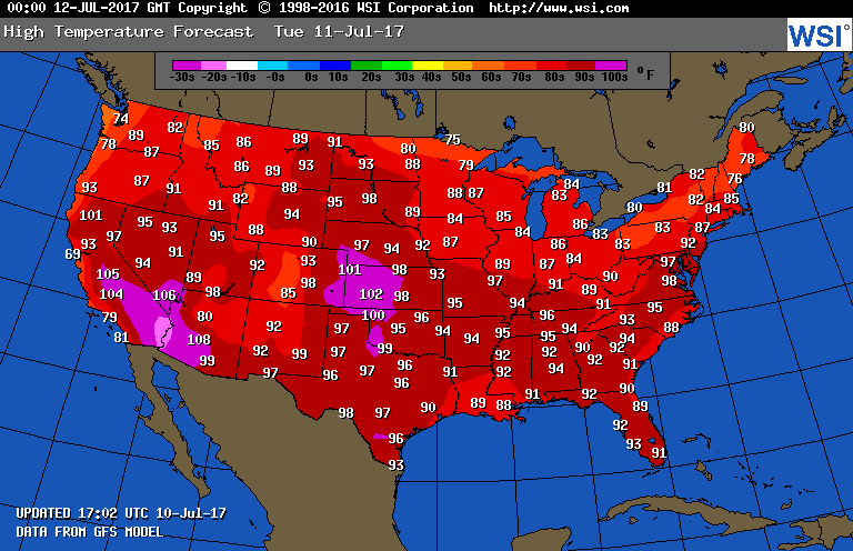
I would not anticipate many record highs to be set the next couple of days in the U.S., but that does not mean that dangerous heat won’t be present. 97F at Washington D.C. is plenty hot, for example, and temperatures at that level can easily lead to heat stroke.
Speaking of heat wave related deaths, I saw this unfortunate report from the Category 6, Weather Underground blog by Dr. Jeff Masters quoted here: “Las Vegas has now had 23 straight days with a high temperature of 105° or higher, breaking the previous record of 21 consecutive days, set in 2015. The latest forecast for Las Vegas calls for at least ten more days in a row of 105° temperatures, which would give the city 33 consecutive days of 105° or higher. There have been 12 heat deaths in the Las Vegas area so far this year.”
The more reliable European model at that 240 hours out threshold does forecast a heat wave for the nation’s heartland, but does not have a dreaded hurricane making a pass at the U.S.
I’ll be adding to this post with updates later this evening.
To see all 2017 heat diary entries click:
https://guyonclimate.com/category/heatdiary2017/
The Climate Guy
__________________________________________
Sunday Evening July 9th updates:
Dear diary: Here are the maxes from 7/9/17:
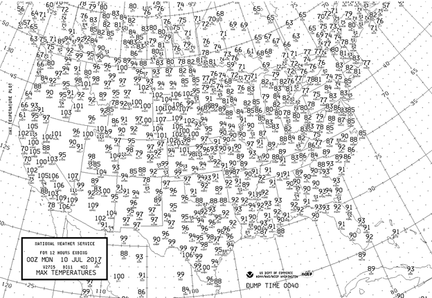
I’m very impressed with the heat in South Dakota and Nebraska. Model guidance was too low there.
Record highs are falling mainly in the West. Let’s first take a close look at The city in the heart of that ridge, Salt Lake City:

According to MDA Weather services, as depicted in yellow, there have been three daily record highs in the last four days. As stated earlier in this blog, temperature guidance may be too low at Salt Lake City, and this certainly was the case for the first nine days of July. SLC maxed out at 101F today.
Rapid City, SD tied their record of 106 last set in 2005.
Montana got in on the record act today where Missoula reached 101F beating by 2 degrees the old mark of 99F set in 1943.
Talk about hot! The U.S. heat capital, Death Valley, CA had it’s 5th warmest average temperature for a calendar day on 7/8 with a low of 103F and a high of 126F (image from MDA Weather Services):
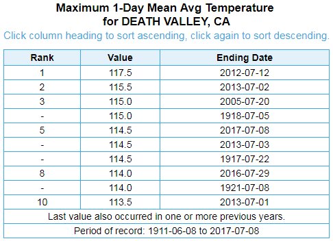
This chart is very interesting, climate wise. Seven of the ten highest averages occurred during or after 2005. Both U.S and global averages have been spiking since then. Coincidence? I think not.
The Climate Guy
Sunday July 9th… Dear diary. After looking at the latest model ensembles, I’m beginning to think that this will be the summer of the western heat ridge. That pesky ridge will edge into the Midwest and South later this week, but probably only a few days. In meteorological terms, the ridge will retrograde, or move back to the west, by next weekend. Most models strengthen the ridge again once it gets parked over or near the central Rockies:
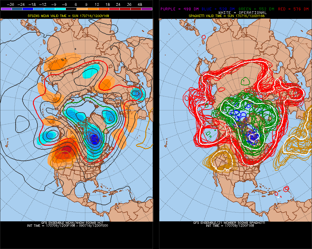
Looking at the Penn State ensembles, it would appear that when the ridge builds, it will be hotter next time around in the northern Rockies and Pacific Northwest. The Southwest may see some relief from more numerous storms since the heart of the ridge may be far enough north to allow for more instability along with some monsoonal flow moisture. No matter how you slice the scenario though, it will remain blisteringly hot at lower elevations of the West this week. There are no signs of the western ridge breaking down at least through the third week of July.
Western record reports are starting to come into the National Center for Environmental Information surface records database for July. It looks like July 2017 has a good chance now of being the 32nd consecutive month of more daily high than low records in the NCEI database for the U.S.

What’s happening this month is that the number of reports of cold records set in association mainly with the East Coast cold trough are not enough to come close to the number of record highs set in the West. This is the point of the 2009 Meehl study I was a part of. There will be cold enough weather, even by the end of the 21st century, to set record lows anywhere in the U.S., but most of the time heat will trump cold.
Tomorrow as the ridge moves eastward the central Plains will heat up to dangerous levels, but most places there will be below record levels. The Southwest will continue to sizzle, but there will be enough moderation in temperatures for most locations to be below record limits.
The hot weather has spawned many western fires both in the U.S. and western Canada.
Quoting the linked NPR article, “Hot and dry conditions in the West are feeding wildfires in the U.S. and Canada, prompting evacuation orders for thousands of people. In California, some 5,000 firefighters are battling 14 large wildfires, state officials say.”
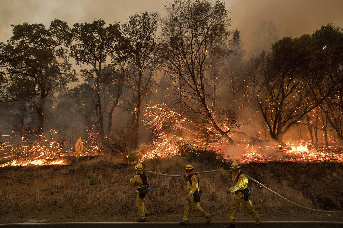
Photo: “Firefighters try to keep a wildfire from jumping a street near Oroville, Calif., on Saturday. Evening winds drove the fire through several neighborhoods, leveling homes in its path.” Noah Berger/AP
Disturbingly, flooding almost led to the Oroville, CA dam to collapse during the winter, which was an item much in the news.
It’s not only humans that can die due to these torrid conditions, but farm animals, as well. This article from the L.A. Times indicates that thousands of cattle have died due to the heat if the last few weeks in the Southwest:
http://www.latimes.com/local/lanow/la-me-cattle-deaths-20170708-story.html
I’ll be adding to this post with updates later today.
To see all 2017 heat diary entries click:
https://guyonclimate.com/category/heatdiary2017/
The Climate Guy
2 thoughts on “Summer Heat Diary… July 9-10, 2017”