Saturday November 11th… Dear Diary. Brrr! For mid-November it’s very cold from the Midwest into the Northeast. Here is another list of record lows from Greg Diamond of The Weather Channel that were set this morning:

Speaking of the Weather Channel, I got a good note from one of my former bosses, Dr. Peter Neiley, indicating how intense this cold outbreak was from several of his associates:
- ———- Forwarded message ———-
From: Matt Rogers <matt@commoditywx.com>
Date: Fri, Nov 10, 2017 at 6:46 PM
Subject: Re: Record lows at 2pm
To: MAP@listserv.albany.eduHi Mappers!The record low in Chicago (ORD) this morning (18) was their first November record low in the 2000s from what I found.Matt - Dear Mappers,We awoke to a 9F low this morning in Madison – one of only 6 days in history on which the daily minimum has been less than 10F (in a record that stretches back 154 years!) in the first 10 days of November. I’m amazed at the -44 F at Inukjuak, QUE this morning – that is about as cold as it ever gets at 500 mb in North America and its only November 10!Sincerely,Jon Martin
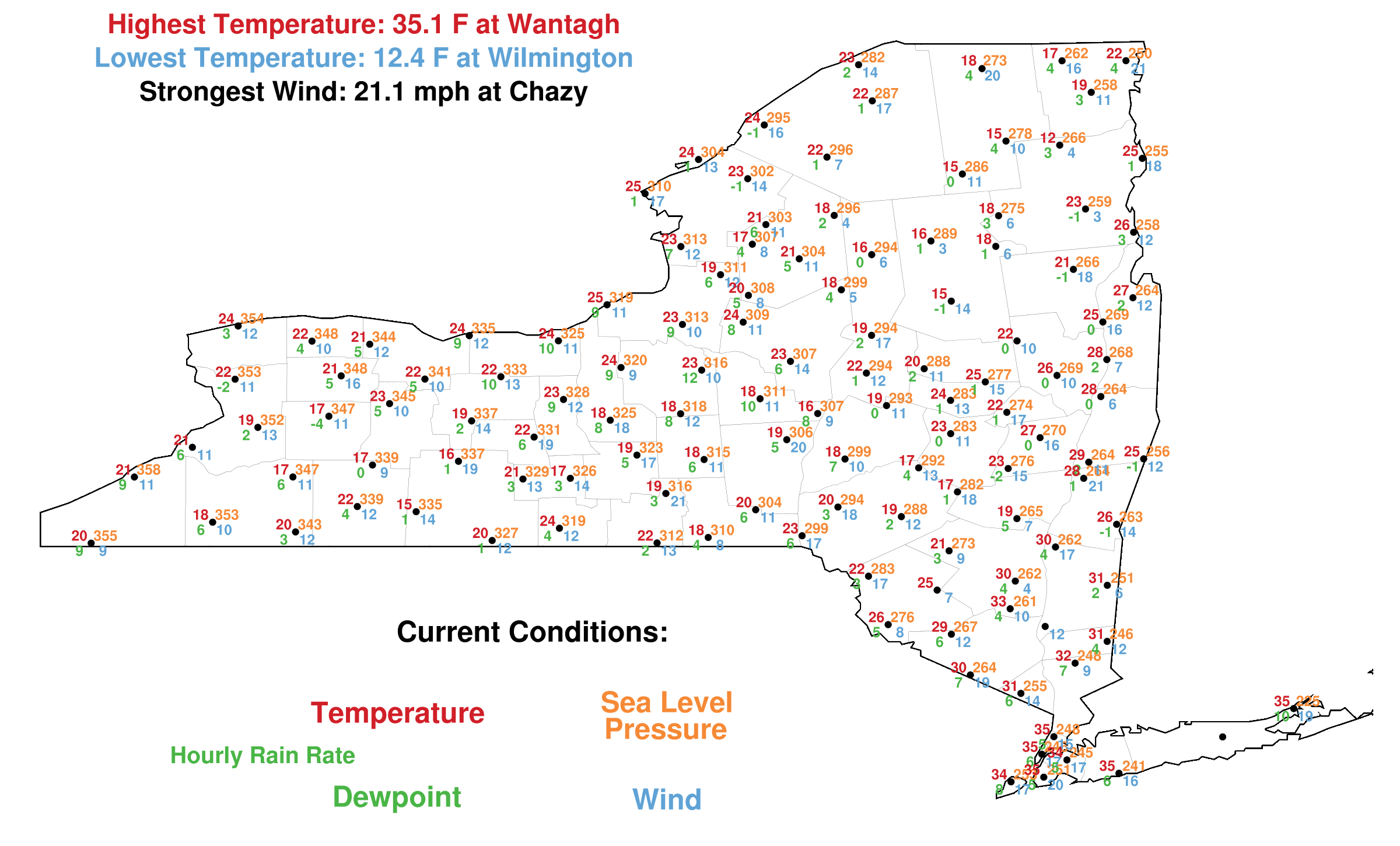
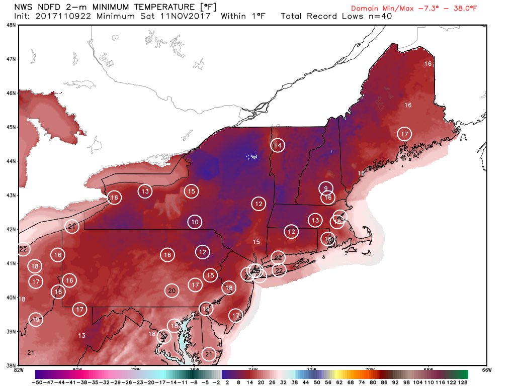
- To reinforce how significant of a departure this cold spell is from our recent weather (which has been well above average for the last two months), I offer the following two maps.Here’s a plot of the lowest record NYSM temperature over the last 90 days, ending yesterday: http://operations.n
ysmesonet.org/~nbassill/archiv e/2017/11/10/climate/threemont hlyminimum.pngNow here’s a plot of NYSM weather at 19 UTC: http://operations.nysmeso net.org/~nbassill/archive/ 2017/11/10/snapshots/1900snaps hot.pngIf you flip back and forth between the two, you’ll note that nearly all stations are/were colder today at 1 pm than at any point in the previous 90 days (which isn’t even factoring in wind chill!). Nick Bassill, PhD
Modeler & Meteorologist, New York State Mesonet
Here are those chilly plots for everyone’s perusal:

What stands out too me among all of this is the fact that, relatively speaking for the time of the year, it has not been this intensely cold in a very long time. Is this the first time this century that Chicago has seen a record low for the month of November? I’ll definitely do some checking.
I’ll add more relevant information to this post should it cross my radar.
The Climate Guy
Friday November 10th… Dear Diary. The expected cold shot across the Great Lakes and Northeast from Thursday through the weekend is already producing record lows throughout the upper Midwest. Here is a list of records from some major sites from Greg Diamond of The Weather Channel:
Some record lows that have fallen so far today:
Int’l Falls, MN: -14°
Duluth, MN: -5°
Pellston, MI: -5°
Sault Ste. Marie, MI: 0°
Gaylord, MI: 1°
Madison, WI: 9°
Green Bay, W: 11°
Dubuque, IA: 12°
Rockford, IL: 14°
Flint. MI: 16°
Chicago: 18° (t)
Muskegon, MI: 20°
The previous record daily low at International Falls was 0 set in 1979 breaking the old record by a whopping 14 degrees, so this is quite the record cold air mass moving into the Northeast. Also -14F is the coldest reading in recorded history at International Falls for so early in the season. Numerous record lows should be set across the Northeast tomorrow :
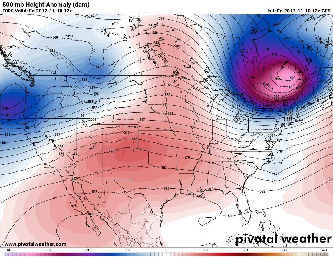
Aloft the system responsible for ushering in the Canadian cold air was grazing the Northeast this morning:
I’m beginning to see signs of a nasty cold, snowy pattern developing for the eastern U.S. after another brief period of warmth, and this week’s chill is just a precursor. Ironically, warm air due to carbon pollution can build over the arctic more rapidly than in prior decades sometimes forcing the jet south, pinching off remaining cold pockets aloft forming closed upper level lows, or storm systems. Such could be the case through the remaining of this month. Here is one such scenario valid for next Saturday:
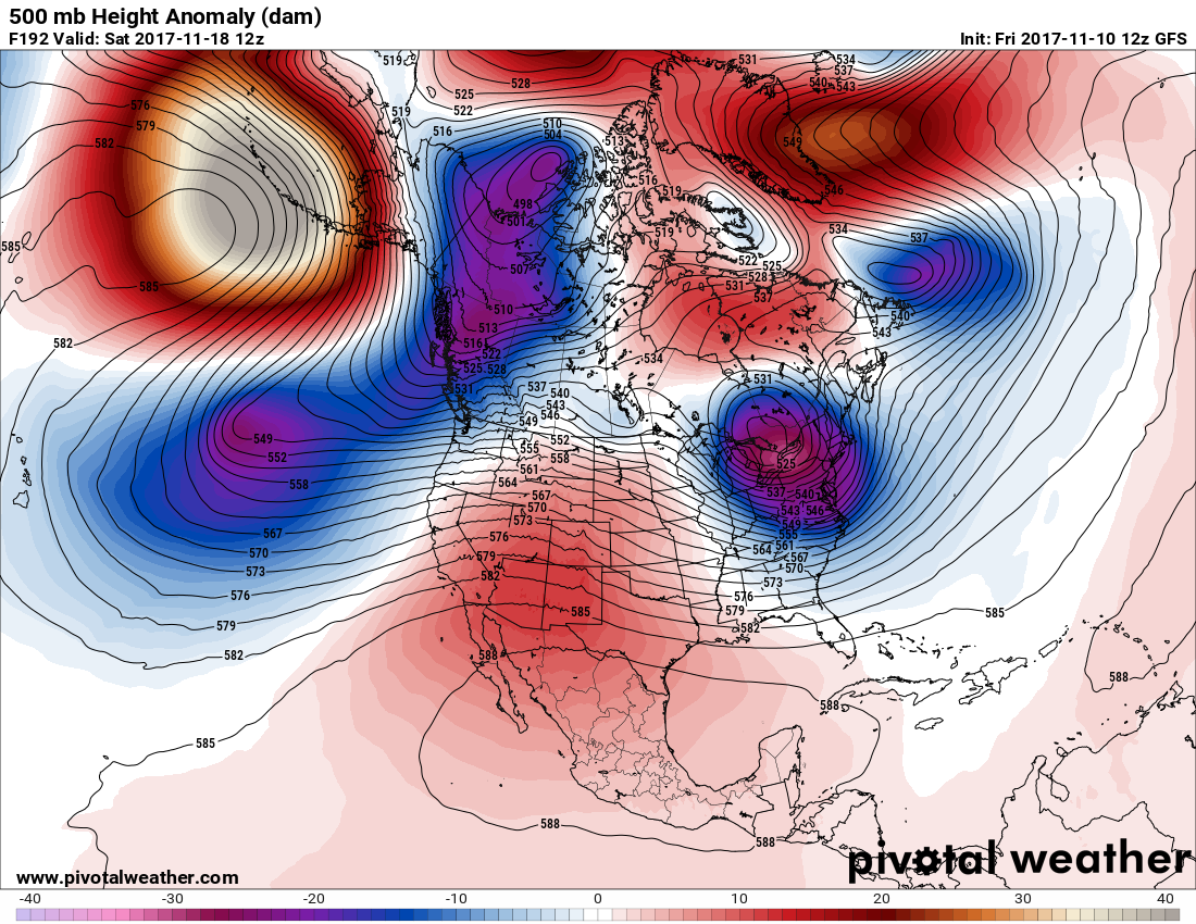
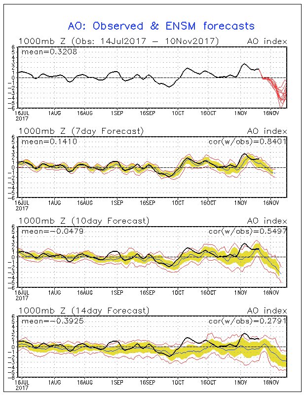
This closed low and associated cold air in the East would be even colder than that currently in the Midwest. Note the red, warm forecast heights over Hudson Bay and Greenland. These would be in association with what is termed the negative phase of the Arctic Oscillation. When warmth appears at these high latitudes usually cold troughs or upper lows form in the eastern U.S. As noted by NortheasternWeather the AO is tanking into negative values:
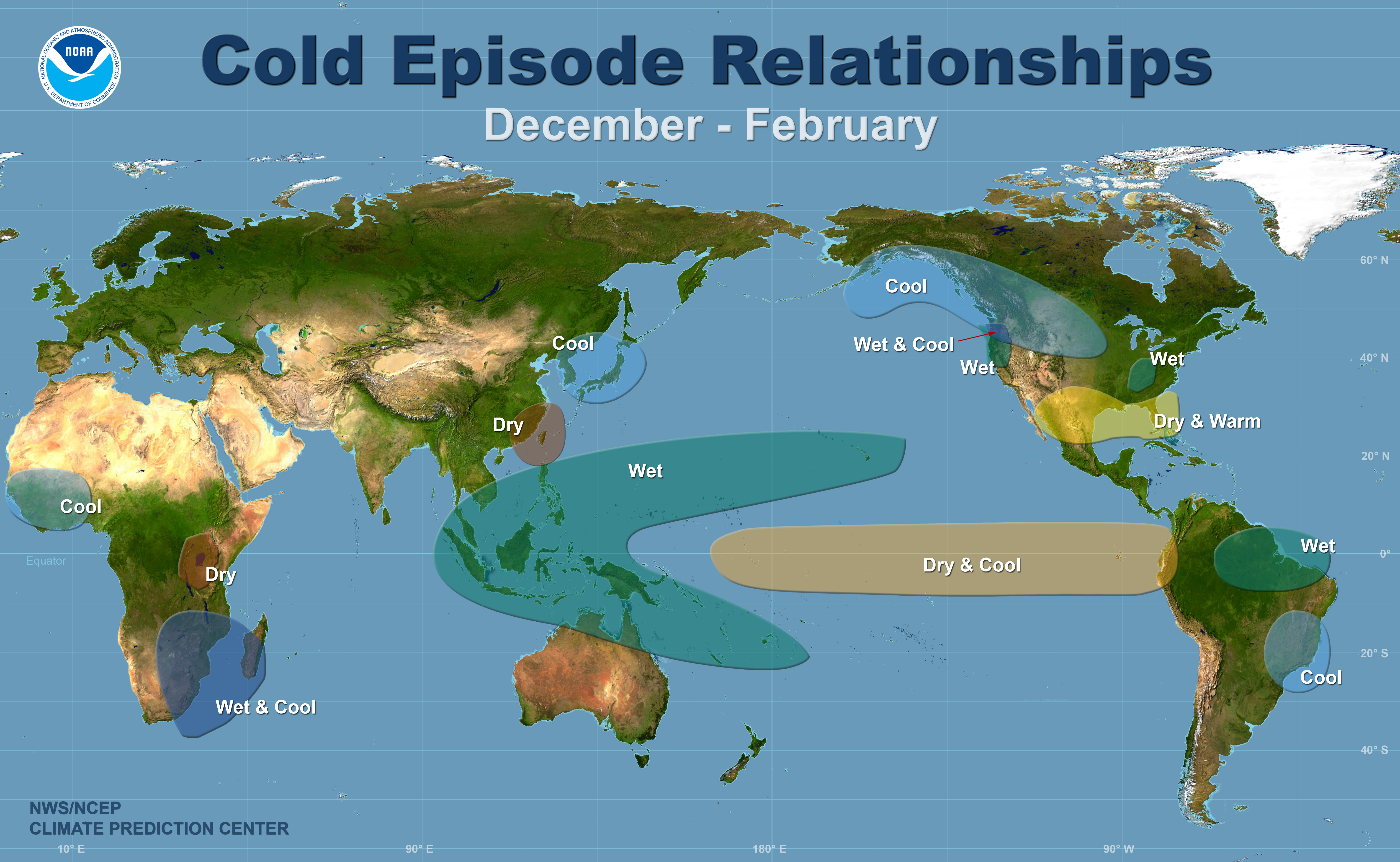
La Niña is here to stay for the winter of 2017/2018. My friend Bob Henson has done a masterful job relating La Niña to the North Atlantic Oscillation (or Arctic Oscillation) and the potential for cold in the U.S. here:
I’ve borrowed the main graphic from the post showing what to expect in association with La Niña:

Above: This map show the most commonly experienced impacts related to La Niña (“cold episode,” bottom) during the period December to February, when the phenomenon tends to be at its strongest. Image credit: NOAA/NWS Climate Prediction Center.
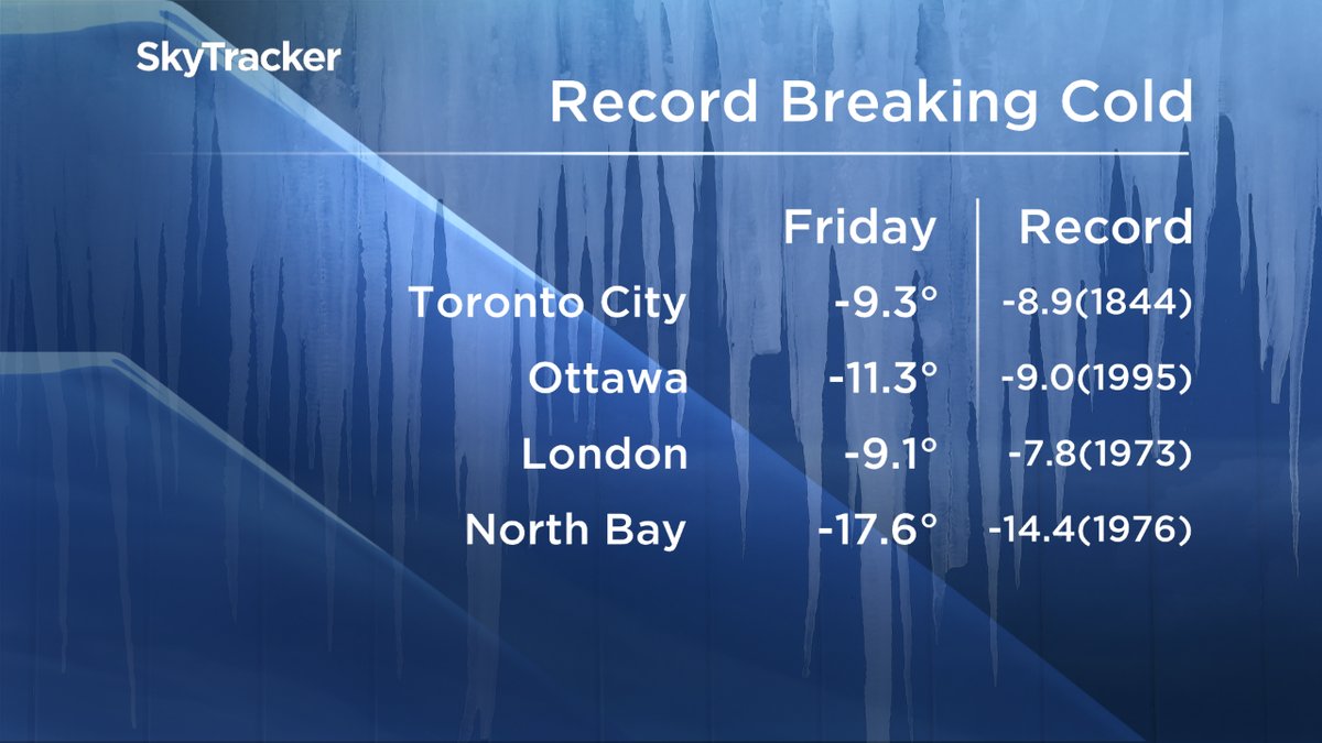
Update: Here are some record lows from Canada from Anthony Farrell in Toronto. These readings are in Celsius:
I’ll be adding to this post if relevant information crosses my radar.
The Climate Guy