Thursday April 25th… Dear Diary. The main purpose of this ongoing post will be to track United States extreme or record temperatures related to climate change. Any reports I see of ETs will be listed below the main topic of the day. I’ll refer to extreme or record temperatures as ETs (not extraterrestrials).😉
Kenneth To Strike Arras Already Affected By Idai
Unfortunately, today I need to report another climate change emergency. As I am writing this post powerful Cyclone Kenneth, which is near category 4 strength, is closing in on Mozambique, and will gravely affect areas already hit hard by Cyclone Idai. Hurricanes are called cyclones in the Indian Ocean. For this post’s main topic I will rely on information coming from Weather Underground. Dr. Jeff Masters and Bob Henson do a lot of great expert analysis when it comes to the tropics. Here is what I am seeing so far:
Today I will quote some from this article, which I encourage all to read in its entirety:
https://www.wunderground.com/cat6/Kenneth-Slams-Comoros-Islands-En-Route-to-Mozambique
The strongest storm in the history of the Comoros Islands (population 1,000,000)—Tropical Cyclone Kenneth—was pounding the island chain off the southeast coast of Africa with 85-mph sustained winds on Wednesday morning. Kenneth, a Category 1 storm at the time, was headed west-southwest towards the largest island in the Comoros, Grande Comore, with a population of 316,000. On Thursday, the storm will deliver a punishing blow to Mozambique, a nation still reeling from the catastrophic mid-March landfall of Tropical Cyclone Idai. Idai killed over 600 people and brought damages in excess of $1 billion to Mozambique—their costliest natural disaster in history. Kenneth will primarily affect northern Mozambique, which has a much smaller population than the central parts of the country that received the brunt of Idai.
As of the 2 pm EDT Wednesday advisory from the Joint Typhoon Warning Center (JTWC), Kenneth had 115-mph winds, making it the equivalent of a Category 3 hurricane. Kenneth was headed just south of due west at 13 mph. Earlier Thursday, the agency issuing the official forecasts for the South Indian Ocean, RSMC-La Reunion, put Kenneth’s top winds at 80 mph (10-minute average), with a central pressure of 978 mb. Kenneth was under light to moderate wind shear of around 10 knots, over warm waters with sea surface temperatures of 29 – 30°C (84 – 86°F), and had excellent upper-level outflow—conditions very favorable for strengthening.

Figure 1. Predicted surface winds (colors) at 12Z (8 am EDT) Thursday, April 25, 2019, from the 6Z Wednesday run of the HWRF model. The model predicted that Tropical Cyclone Kenneth would be approaching landfall in northern Mozambique on Thursday at around 12Z (8 am EDT and 2 pm local time) as a Category 3 storm with 125 mph winds. Image credit: tropicaltidbits.com.
If Kenneth makes landfall as a major Category 3 or stronger storm, wind and storm surge damage will be a big concern. Because Kenneth is in the Southern Hemisphere, its clockwise circulation will push the strongest winds and storm surge toward the south of the landfall location. The brunt of Kenneth’s landfall impacts may thus end up in the sparsely populated Quirimbas National Park region, including the archipelago of the Quirimbas Islands.

| Figure 2. Predicted precipitation for the period 6Z April 24 – 12Z April 29, 2019, from the 6Z Wednesday run of the HWRF model. The model predicted that Tropical Cyclone Kenneth would bring widespread rainfall amounts in excess of 8″ (yellow colors) to coastal northern Mozambique, with a small area of rains in excess of 24” (red colors) along portions of the coast. Additional rainfall is possible beyond April 29 wherever a weakening Kenneth might happen to linger. Image credit: NOAA. |
Heavy rains the main threat
Kenneth will be a very wet storm at landfall and will be decelerating, moving at less than 10 mph. The storm is expected to meander just inland after landfall for a day or more, keeping a portion of its circulation over water and thus allowing the storm to dump potentially catastrophic rainfall amounts over northern Mozambique. Kenneth may even re-emerge over the ocean this weekend, allowing regeneration into a tropical cyclone and bringing renewed heavy rains to coastal Mozambique. The 6Z Wednesday run of the HWRF model (Figure 2) predicted that Kenneth would bring a deluge of over 8” of rain to a wide swath of coastal northern Mozambique, with a smaller region of rains in excess of 24” near where the center comes ashore.
The cyclone’s impact could delay the giant natural gas projects Exxon Mobil and Anadarko are planning to start building in Mozambique’s northernmost province of Cabo Delgado later this year. Extreme flooding from Kenneth may also cause severe hardship for an emerging Islamist insurgency with remote bases in forested coastal areas near the Mozambique-Tanzania border.
In a Wednesday update on Kenneth, ReliefWeb noted: “Tropical Cyclone Kenneth is expected to become only the third satellite-era system to evolve to a moderate tropical storm stage or higher in the area north of the Mozambique Channel, according to Meteo France. The other two systems concerned, Elinah in 1983 and Doloresse in 1996, did not reach the African coast. Tropical Cyclone Kenneth therefore threatens an area where the population is not used to cyclones.”
Comoros Islands tropical cyclone history
The Comoros Islands have very little experience with tropical cyclones, since the islands lie very close to the equator—between 11° and 13°S latitude. According to EM-DAT, the Comoros have endured only three damaging tropical cyclones since 1983. The deadliest and most destructive was Tropical Cyclone Elinah, which passed through the islands as a tropical storm with 45 – 50 mph winds on January 11, 1983, killing 33 people and doing $23 million in damage. All 33 deaths occurred when a huge wave swept 40 people on the island of Anjouan into the water. The last time a hurricane-strength tropical cyclone affected the islands was on February 17, 1996, when Category 1 Doloresse passed about 40 miles to the west of the northern Comoros Islands.
Tanzanian tropical cyclone history
Kenneth is likely to dump up to a foot of rain in southern Tanzania, a nation that has almost no experience with tropical cyclones. According to NOAA’s historical hurricanes database, only two tropical cyclones have ever made landfall in the country: an unnamed 1952 tropical storm, and Tropical Depression Atang of 2002. EM-DAT lists only one deadly tropical cyclone in Tanzanian history, Tropical Cyclone Nadia, which made landfall in northern Mozambique about 120 miles south of the border with Tanzania. Flooding from Nadia killed 4 people in Tanzania.
The aftermath of Cyclone Idai in Mozambique
Tropical Cyclone Idai made landfall on March 14 as a Category 2 storm with 110 mph winds just north of Beira, Mozambique (population 530,000) near the time of high tide, driving a devastating storm surge into the city. Idai also caused enormous wind damage, ripping off hundreds of roofs in Mozambique’s fourth largest city. Since the cyclone was large and moving slowly at landfall, near 6 mph, it was a prodigious rainmaker, with satellite-estimated rainfall amounts in excess of 2 feet in portions of central Mozambique.
The official death toll for Idai on April 23 stood at 1007, with 602 killed in Mozambique, 344 in Zimbabwe, 60 in Malawi, and 1 in Madagascar. Total economic damage to infrastructure in Mozambique alone was estimated at $1 billion (over 8% of their GDP)—their most expensive natural disaster in history. The World Bank estimated that combined damages to Mozambique, Zimbabwe, and Malawi would exceed $2 billion.
As of April 22, Relief Web reported that 73,000 people in Mozambique were living in shelters, and 1.85 million people were in need of assistance. Approximately 6600 cases of cholera had been reported, including at least 7 deaths, but the number of cases was on the decline, thanks to a successful vaccination effort.
How to help
The International Federation of Red Cross and Red Crescent Societies, the United Nations, Save the Children, and the International Medical Corps have targeted donation links so you can help provide food, medical supplies, and shelter to victims of Idai in Mozambique. Doctors Without Borders is also doing great work in Mozambique, and their general donation page is here.
Bob Henson co-wrote this post.
The Weather Company’s primary journalistic mission is to report on breaking weather news, the environment and the importance of science to our lives. This story does not necessarily represent the position of our parent company, IBM.

The only item that I will add are worldwide sea surface temperature anomalies:
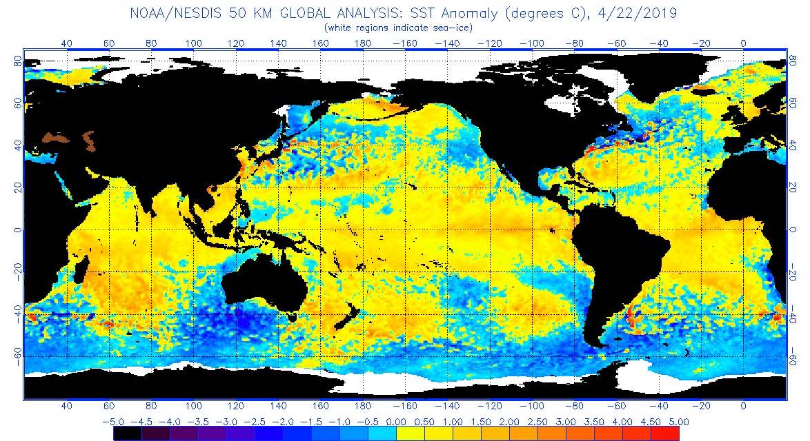
Notice around the horn of Africa that water temperatures are above average. Too, and perhaps most importantly, Kenneth’s forward motion will decrease to a crawl and maybe stall just inland much like Harvey did over southeast Texas in 2017, producing extreme rainfall totals. This next tragedy is obviously being fueled by carbon pollution warmth permitting not one but two powerful cyclones to form and hit the same general area.
Update: Here is this afternoon’s post. Unfortunately Kenneth indeed ramped up to a category 4 system:
Quoting this latest article:
Kenneth and the influence of climate change
Kenneth’s landfall in Mozambique as a Category 4 storm with 140 mph winds makes it the strongest landfalling tropical cyclone ever observed in mainland southeast Africa. Just last month, Mozambique had its fifth strongest landfalling cyclone on record, Idai, which was a Category 2 storm with 110 mph winds when it hit. It’s pretty remarkable that two of the top five strongest cyclones in the region’s history have occurred this year, which raises the question of whether human-produced climate change may have played a role.
We can say that climate change probably made the odds of such an unusual occurrence more likely, but we have to remember that regular satellite imagery of the Southwest Indian Ocean only began in 1998. Since climate change is best studied using datasets of 30 years or longer, the mere 21-year-long satellite data record for the basin makes it difficult to say specifically how climate change is affecting Southwest Indian Ocean tropical cyclones.
We should expect that Kenneth’s heavy rains are being increased due to climate change, though, since one of the more confident predictions hurricane scientists can make on the future of tropical cyclones in a warmer climate is that they will dump heavier rains due to increased moisture in the atmosphere. A study done for Hurricane Harvey of 2017–Wang et al. (2018), Quantitative attribution of climate effects on Hurricane Harvey’s extreme rainfall in Texas–found that warming of the atmosphere and ocean since 1980 could have increased Hurricane Harvey’s extreme precipitation by 13% – 37%.
As detailed in our June 2018 post, Observed Slowdown in Tropical Cyclone Motion May Portend More Harvey-Like Rainstorms, a 4% slowdown in the forward speed of tropical cyclones in the Southwest Indian Ocean has been observed in recent decades. Cyclone Idai’s very slow motion at landfall—les than 10 mph—greatly contributed to it highly destructive rains, and Kenneth will also dump a huge amount of rain due to it very slow motion at landfall. It is uncertain if this trend is due to human-caused global warming, but there are good reasons to believe that this could be the case.
Tropical cyclone storm surges worldwide are definitely worse because of climate change. Global sea levels are about 8” higher than they were a century ago, and this extra rise allows the storm surge of all tropical cyclones to cause increased destruction.
Probably the most sophisticated study done yet on what the future may hold for tropical cyclones on the Southwest Indian Ocean was a 2018 paper, Projected Response of Tropical Cyclone Intensity and Intensification in a Global Climate Model, which used a high-resolution global climate model (HiFLOR). The 2018 study predicted a dramatic increase in the global incidence of rapid intensification due to global warming, and a 20% increase in the number of major hurricanes globally in the climate of the late 21st century. For the Southwest Indian Ocean, the model did not predict a significant increase in the number of days Category 3 and stronger cyclones would affect Mozambique, but did for nearby Madagascar and Mauritius.
I’ll add more information on Kenneth to this post in the next few days.
…………………………………………………………………………………………………………………….
Here is more weather and climate news from Thursday:
(As usual, this will be a fluid post in which more information gets added during the day as it crosses my radar, crediting all who have put it on-line. Items will be archived on this site for posterity. In most instances click on the pictures of each tweet to see each article.)
(If you like these posts and my work please contribute via the PayPal widget, which has recently been added to this site. Thanks in advance for any support.)
Guy Walton- “The Climate Guy”