Friday May 3rd… Dear Diary. The main purpose of this ongoing blog will be to track United States extreme or record temperatures related to climate change. Any reports I see of ETs will be listed below the main topic of the day. I’ll refer to extreme or record temperatures as ETs (not extraterrestrials).😉
Furious Fani Hits India
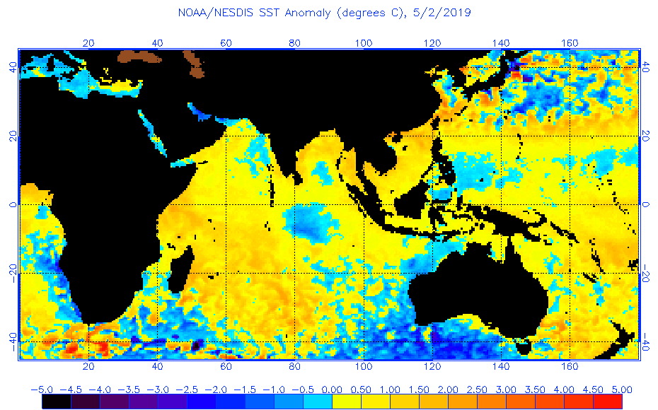
By now Cyclone Fani is quickly winding down over eastern India, and plenty has been written on the storm from meteorological circles and media, such as the New York Times and Washington Post. This evening what I will do is cobble together some interesting reports and links on Fani for my readers to peruse. Before doing that, though, let’s point out one climate change factor that probably made Fani stronger, above average sea surface temperatures:

Except for a relatively small patch, all of the ocean off the east coast of India has above average sea surface temperatures. It’s no wonder that the Indian Ocean, which isn’t experiencing much shear this season, is spawning a lot of tropical activity (just click on the tweet to get a French to English translation).
Don’t get me wrong, Fani was not unprecedented, just ferociously strong by Indian Ocean standards; thus somewhat rare:
I’ll report any tie-ins to climate change from academia the next few months.
Now here are some interesting reports linked to this post and awesome videos showing the power of Fani:
Briefly quoting the Washington Post:
By Jason Samenow May 3 at 10:39 AM
(This story, first published Thursday evening, was updated on Friday.)
Cyclone Fani, equivalent to a Category 4 hurricane, plowed into eastern India Friday morning local time, unleashing destructive winds, storm surge flooding, and torrential rain. It was the strongest storm to strike the country since 2014.
The storm, packing winds of over 130 mph, made landfall in Puri, a coastal city of 200,000 in the state of Odisha. Social media video showed violent winds blasting sheets of rain sideways and its streets littered in debris.
The storm rapidly intensified Wednesday into Thursday, its peak winds hitting 155 mph. In the Bay of Bengal, these winds were the strongest so early in the year since the Bangladesh cyclone of 1991 and the sixth-strongest on record. Such winds were just 2 mph shy of a Category 5 hurricane.
Weather Underground’s Bob Henson wrote the surge could be “catastrophic” near and east of Puri. “Because of the geography of the Bay of Bengal, which funnels and concentrates storm surge toward its north end, dangerous surge from Fani may extend to the West Bengal coast, potentially affecting areas from the coast toward Kolkata (metro area 14 million),” he wrote.
I will be adding more reports on Fani with time to this post.
…………………………………………………
Here are some more climate and weather news items from Friday:
(As usual, this will be a fluid post in which more information gets added during the day as it crosses my radar, crediting all who have put it on-line. Items will be archived on this site for posterity. In most instances click on the pictures of each tweet to see each article.)
(If you like these posts and my work please contribute via the PayPal widget, which has recently been added to this site. Thanks in advance for any support.)
Guy Walton- “The Climate Guy”