Main Topic: California Continues to Burn In October…Monday…Situation Gets More Dire
Many of you over the last 24 hours have wanted me to explain this tweet, going into more detail:
Let’s briefly dissect the synoptic situation currently occurring across California in terms of “climate dominoes” before looking at many new fire messages, which will continue to be part of the main topic of each day until large conflagrations get under control.
First, what do we see as far as the jet stream pattern across the Northern Hemisphere as of Monday morning? We have:

We see quite a bit of anomalous warmth around the Arctic with one huge cold low “cut off” from western Canada into the western U.S. The jet pokes northward into Alaska around about the 576 decameter line of geopotential heights and dives southward through the western U.S. You can see that there is a sharp gradient of heights across California and much of the West. This “dipole” pattern is a climate change domino signature due to a) high amplitude and b) stagnation, or relatively little or slow movement as described in work by Dr. Michael Mann, Dr. Daniel Swain, and Dr. Jennifer Francis. Warm air has essentially squeezed the anomalous cold pocket southward into the U.S. I contend that without Arctic warming there would be less amplitude in the jet for this time of the year.
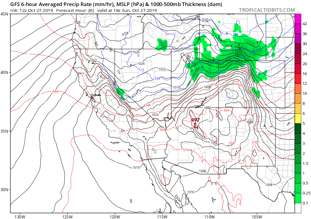
The next domino to fall would simply be associated cold air from the jet stream buiding at the surface into Nevada and the Great Basin producing an extremely tight pressure gradient over California. We saw this at its peak Sunday morning:

Record cold air will continue to persist in the Rockies:
In turn the last dominoes to fall would be record strong Diablo and Santa Ana winds plus very dry if not record dry vegetation due to near record summer heat, which is also a climate change signature. So, voila you get awful phenomena like the Kinkade Fire:
And:
Without further ado here are news and notes from Monday on California’s high winds and fires. Newest items, as usual, will be listed at the top of this post, which I will update as Monday rolls along:
Here is more climate and weather news from Monday:
(As usual, this will be a fluid post in which more information gets added during the day as it crosses my radar, crediting all who have put it on-line. Items will be archived on this site for posterity. In most instances click on the pictures of each tweet to see each article.)
(If you like these posts and my work please contribute via the PayPal widget, which has recently been added to this site. Thanks in advance for any support.)
Guy Walton- “The Climate Guy”