Friday November 1st… Dear Diary. The main purpose of this ongoing blog will be to track United States extreme or record temperatures related to climate change. Any reports I see of ETs will be listed below at the very end of this daily blog. I’ll refer to extreme or record temperatures as ETs (not extraterrestrials).😉
Water World…New More Dire Assessments From Climate Central
Dear Diary. Welcome to November everyone. In the last few days Climate Central has announced that they have completed intricate maps and charts that show almost block by block where coastal cities and communities will be inundated from carbon pollution related sea level rise. As usual, the news here is not good showing that societies around the globe have less time for adaptation plans than previously thought. So, here is what I’m presenting for today’s main topic: (Please click on Bernadette’s video.)
From Weather.com here is a reprint of Bob’s article on this “Water World” subject:
Tens of Millions Could Be Hit by Sea Level Rise Sooner Than Thought, New Study Suggests
By Bob Henson
3 days ago
weather.com
More People At Risk of Sea Level Rise Sooner Than We Thought
A new analysis finds that sea level rise could threaten tens of millions of people sooner than previous work found.
At a Glance
- A new analysis finds that sea level rise could threaten tens of millions of people sooner than previous work found.
- The study uses improved estimates of coastline height in hard-to-sample parts of the world.
- More than 200 million people in six Asian countries may see coastal flooding at least once a year by 2050.
- Even if greenhouse gas emissions decrease by midcentury, coastal vulnerability may be much higher than earlier estimates.
A new analysis of coastlines around the world indicates that sea level rise linked to climate change could lead to annual flooding – and eventually to daily inundations at high tide – more quickly than thought. More than 200 million people may be affected globally as soon as 2050, several times more than previously estimated, the study finds.
While the new study is not the last word on sea level rise, it highlights a persistent underestimation of the vulnerability of many coastlines, according to authors Scott Kulp and Benjamin Strauss of the independent research center Climate Central. The study was published Tuesday in Nature Communications.
“As the tideline rises higher than the ground people call home, nations will increasingly confront questions about whether, how much, and how long coastal defenses can protect them,” said Kulp in a news release. “These assessments show the potential of climate change to reshape cities, economies, coastlines, and entire global regions within our lifetimes.”
Coastal vulnerability is well assessed in the United States, where high-resolution data is widely available. The new findings confirm earlier work by Climate Central showing that U.S. vulnerability will increase this century as sea level continues to rise. NOAA estimates that the national average of five high-tide flood days per year – about twice as much as 20 years ago – might reach 7 to 15 days by 2030 and 25 to 75 days by 2050, with the largest increases along the Gulf and Atlantic coasts.
The new paper shows that coastline vulnerability may be greatly underestimated in developing nations, where high-resolution data is unavailable or sparse.
The study finds that roughly 190 million people currently occupy global land that could be inundated by regular high tides (mean higher high water) by 2100, even if greenhouse gas emissions peak by midcentury. This compares to an estimate of 110 million people from a widely used NASA model.
Under the same scenario, less-frequent annual flooding could affect much more territory as soon as 2050, including land where some 237 million people live today within six Asian countries (China, Bangladesh, India, Vietnam, Indonesia, and Thailand). This compares to earlier estimates of only about 50 million people.
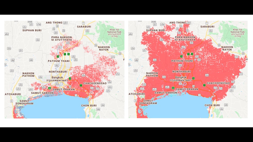
Improved elevation data from CoastalDEM significantly expands the area around Bangkok, Thailand (in red) expected to experience, on average, once-a-year coastal flooding by 2050.(Climate Central)
If emissions keep rising through the century, regular high-tide flooding could occur by 2100 on coastal land where 250 million people now live in those six countries.
Even if greenhouse emissions are cut drastically, more than 20 other nations could see regular high tides by 2100 over land where at least 10% of their population is now located, the study finds.
Getting a Better Bead on Coastal Elevation
The new findings are based on output from CoastalDEM, a digital elevation model (DEM) developed by Climate Central. Because sea level cannot be directly measured with instruments along every inch of coastline, DEMs are used to produce regional and global estimates of which coastlines are most vulnerable to sea level rise.
One of the most commonly used DEMs for international assessment of coastal flood risks is NASA’s satellite-based Shuttle Radar Topography Mission (SRTM). Like most of its counterparts, the SRTM tends to overestimate the height of topography near coastlines, because it detects objects such as trees or buildings that extend higher than the coastline itself. As a result, the impacts of sea level rise can be underestimated.
“Some studies have properly handled the vertical uncertainty,” said Dean Gesch (U.S. Geological Survey) in a 2018 paper on best practices for DEM use. “However, many other studies ignore the vertical uncertainty stemming from the underlying elevation data.”
The CoastalDEM model uses neural networks – a form of machine learning that allows software to make continuous improvements over time – in order to reduce systemic errors in the SRTM data. The model was “trained” on a subset of U.S. coastal locations where dense, high-resolution data was available. It was then tested on other U.S. and Australia locations before being extended to other parts of the world.
According to Climate Central, CoastalDEM reduces the typical coastal elevation error to an average of about 4 inches, compared to 6 feet or more in SRTM.
To calculate vulnerability, the CoastalDEM model output was combined with previous estimates of expected sea level rise, including both lower- and higher-end estimates. The lower scenario assumes that greenhouse emissions will level off by 2040 and then decline (the IPCC’s RCP4.5 scenario).
The higher scenario assumes more rapid emissions increases through the century (RCP8.5), together with the possibility that instabilities within Antarctic coastal ice cliffs could lead to rapid sea level rise later this century, as past research has suggested.
Melissa Moulton, a scientist at the National Center for Atmospheric Research who specializes in coastal oceanography and remote sensing, said in an email that the new findings are a valuable contribution to better assessing impacts of sea level rise.
“These estimates are an important indicator of the threat to our coastal populations,” said Moulton. She noted that actual inundation at any one spot will also depend on how land use changes and on the small-scale hydrologic and geologic evolution of the coastline, factors that are not considered in this study.
“I think this is a very interesting study to assess uncertainties in projecting the impacted population by rising sea level,” said Aixue Hu, a climate researcher at NCAR. “It gives us another angle to look at this problem.”
Hu points out that a number of uncertainties remain, as called out by the researchers themselves. According to Hu, “the results also suggest that better coverage of DEM observations could potentially further reduce the uncertainty.”
A far more precise technique than using DEMs is to carry out fine-scale elevation measurements using airborne lidar (laser-based radar). Such lidar-based data has not yet been collected along many coastlines around the world, but it is available for U.S. coastlines. Using publicly available lidar-based data, Climate Central has published high-resolution risk zone maps for U.S. coastal locations.
The study estimates that some 900,000 U.S. residents are in locations that would be flooded regularly by high tide were it not for levees and other protections.
The authors found that even the CoastalDEM data consistently underestimated the coastal vulnerability in the United States when compared with the finer-scale lidar-based U.S. data.
“Ultimately, the most accurate assessments of vulnerability to rising seas, especially for smaller areas, will require development and public release of improved coastal area elevation datasets building directly off of new high resolution observations increasingly collected by satellites today,” the authors conclude.
The Weather Company’s primary journalistic mission is to report on breaking weather news, the environment and the importance of science to our lives. This story does not necessarily represent the position of our parent company, IBM.
………………………………………………….
So, for all of my U.S. readers shivering on a cold fall day on the first day of November, don’t be fooled by the weather. The planet’s environmental climate system machine is breaking down and will get worse, as far as sea level rise goes. The longer we keep the old climate jalopy out of the garage shop, delaying a big necessary “oil change” to keep the machine going, the worse off we will be. It’s that simple.
Here is more climate and weather news from Friday:
(As usual, this will be a fluid post in which more information gets added during the day as it crosses my radar, crediting all who have put it on-line. Items will be archived on this site for posterity. In most instances click on the pictures of each tweet to see each article.)
Here are some smoky cold “ETs” from this morning:
(If you like these posts and my work please contribute via the PayPal widget, which has recently been added to this site. Thanks in advance for any support.)
Guy Walton- “The Climate Guy”