Thursday January 16th… Dear Diary. The main purpose of this ongoing blog will be to track United States extreme or record temperatures related to climate change. Any reports I see of ETs will be listed below the main topic of the day. I’ll refer to extreme or record temperatures as ETs (not extraterrestrials).😉
A Colder Weather Pattern For The United States, But How Cold?
Dear Diary. It’s been a relatively warm start to 2020 across the lower 48 states, average wise, due to a record breaking air mass that slipped through the Midwest and East the first half of January. These numbers don’t lie:
Meteorological models for the past week have advertised a colder weather pattern for the United States going into the second half of January, but will air masses moving southward through the Midwest into the Southeast be cold enough to substantially lower that 20.2 ratio? Looking at today’s guidance I think not.
Let’s do some spot checking.
For the Deep South next week I’m not impressed with guidance for my home town of Atlanta. Lows in the 20s would not be close to record values in the single digits and teens:

What about the Midwest? For Chicago this is what we see:
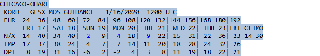
Threadex indicates that lows in the single digits at Chicago would not be records for the 19th through 21st:
No where close:
Date (ORD): daily record. 2nd place. 3rd place.

For reference here is the forecast pattern we see across North America valid for the 21st:
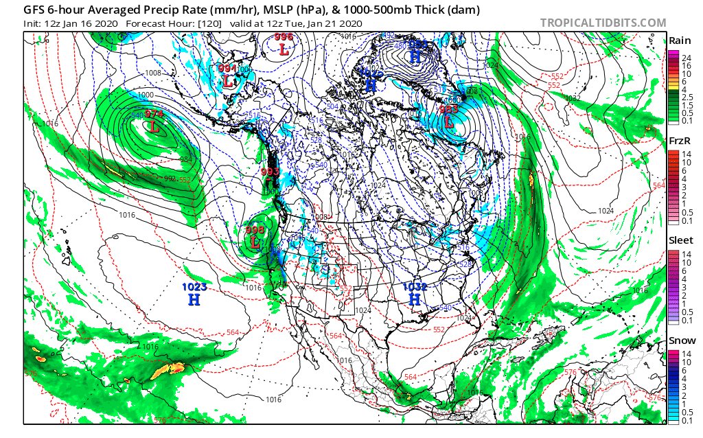
Granted, wintry bone chilling cold will return for much of the country, but will we see hundreds of record low reports next week from this weather pattern? Probably not. Thickness values are lowest in northern New England, so let’s check out Caribou, Maine:
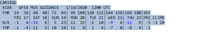
Again, nowhere close:
Date (CAR). daily record. 2nd place. 3rd place.

I’ll endeavor to let all of my readers know if this coming cold weather gets exceptionally cold enough going into February to produce numerous cold records. There might be a smattering from what I can tell next week but not many. Anyway, it will get cold enough for hypothermia, so please do bundle up, taking precautions, and do stay warm despite that global warming thing.
Here is more climate and weather news from Thursday:
(As usual, this will be a fluid post in which more information gets added during the day as it crosses my radar, crediting all who have put it on-line. Items will be archived on this site for posterity. In most instances click on the pictures of each tweet to see each article.)
Here is an “ET” from Denmark:
(If you like these posts and my work please contribute via the PayPal widget, which has recently been added to this site. Thanks in advance for any support.)
Guy Walton “The Climate Guy”