Friday February 21st… Dear Diary. The main purpose of this ongoing post will be to track United States extreme or record temperatures related to climate change. Any reports I see of ETs will be listed below the main topic of the day. I’ll refer to extreme or record temperatures as ETs (not extraterrestrials)😉
Main Topic: Strong Storms Enhanced By Climate Change Pummel Britain
Dear Diary. The jet stream continues to get stuck in one area such that storm systems get tracked right into the British Isles, mainly due to a record strong positive phase of the North Atlantic Oscillation. The positive NAO has led to very warm ridges over mid-latitude areas with one notable location being Europe. On Sunday, as I’ve noted the past week, we will see near record high geopotential heights near the French/Spanish border:
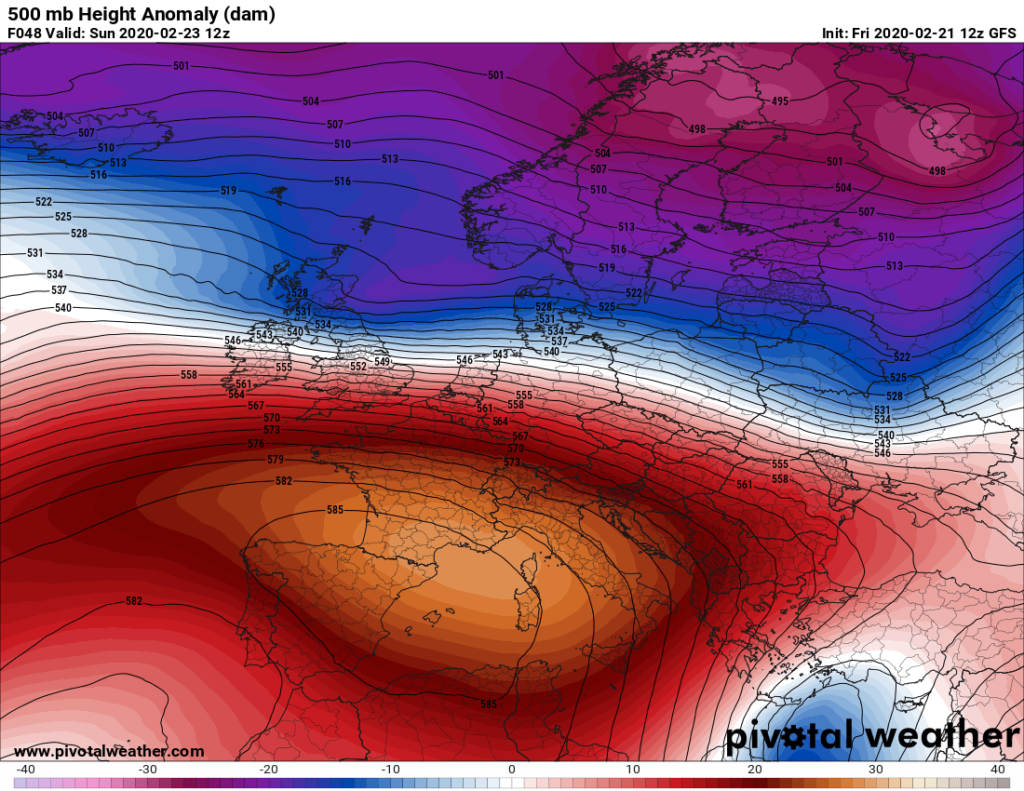
The ridge producing record surface warmth across much of Europe in the last month has added heat or fuel to storm systems riding on its periphery eastward via the jet stream to the north. Two separate storm systems have gotten below 930 millibars, which were in record low pressure territory moving near Iceland and strafing the British Isles. Horrendous, and in some cases unprecedented, flooding was an end result. The latest bulge in the ridge will start to collapse on Monday allowing yet a third storm to bring wind and rain to Britain, although this one should not be nearly as strong as the first two:

For more details on the situation across Britain here is Bob Henson’s post via Desdemona Despair:
Two-fisted storm system pummels Iceland, British Isles – “This is not normal flooding, we are in uncharted territory”

A boy wades through a flooded alleyway in Pontypridd, South Wales, on 16 February 2020. Photo: Neil Munns / EPA-EFE / Shutterstock
By Bob Henson
17 February 2020
(Weather Underground) – A rapid-fire pair of winter storms swept across the North Atlantic from late last week into the weekend, bringing the most widespread flood alerts on record for the United Kingdom and one of the lowest surface pressures ever recorded in this part of the world.
The second and stronger of the storms, named Dennis by the UK Met Office, bottomed out south of Iceland with a central surface pressure estimated at 920 millibars, as noted by weather.com. Only one North Atlantic cyclone is known to have been stronger: a hyper-intense 913-mb cyclone on January 11, 1993, near Scotland’s Shetland Islands. That storm tore apart super oil tanker Braer on a rocky shoal, causing a massive oil spill.

Members of emergency services evacuate residents from flooded houses by rescue boat in South Wales, on 16 February 2020. Photo: Geoff Caddick / AFP / Getty Images
For other memorably intense North Atlantic storms, see the 2013 roundup by Dr. Jeff Masters, featuring research from WU weather historian Christopher Burt and Stephen Burt (University of Cambridge).
A couple of days earlier, another intense North Atlantic cyclone dipped to 929 mb in roughly the same area south of Iceland. The fast approach of Dennis led to a spectacular case of Fujuwhara rotation, in which the decaying first cyclone moved west and south as Dennis took its place. The Fujiwhara effect involves two cyclones near each other that rotate around a point in between, as is often the case with cheek-by-jowl tropical cyclones.
A 929 millibar beast followed by another meteorological bomb as the pressure of Storm Dennis dropped to 920, one of the lowest on record in this part of the world, and then the two combined into a massive cyclone while doing a Fujiwhara dance, 16 February 2020.
Northwest Europe dealt with another intense storm, named Ciara, just a week earlier. That storm brought wind gusts to 125 mph and caused eight deaths. The one-two punch has led to extreme flooding in parts of the British Isles, particularly southern Wales and adjacent parts of southwest England. In Hereford, the River Wye hit its highest level in more than 200 years of recordkeeping on Monday, according to the Guardian.
At one point on Sunday morning, nearly 600 flood alerts and warnings were in effect across England—the most on record for any day there, according to the U.K. Environment Agency. It will take days for the floodwaters to make their way through larger rivers, including the Severn, where flood control structures will be challenged on Monday night. More rain is in the forecast for some of the hardest-hit areas by midweek.
Ciara and Dennis are just two recent examples of an uncommonly stormy winter across the North Atlantic, a region where wild winter weather is already a matter of course. In mid-January, another bomb cyclone dumped record snow across parts of Newfoundland. These fierce storms have been driven largely by a ramped-up contrast between the Arctic and mid-latitudes this winter. In tandem with an exceptionally strong positive phase of the North Atlantic Oscillation, frigid air has stayed largely confined to the Arctic and Alaska, while much of North America, Europe, and Asia has basked in unusually widespread, prolonged mildness. [more]
Two-Fisted Storm System Pummels Iceland, British Isles
All of this can be traced to a planet that is running a big fever, of course. What we have seen in Britain is a direct result of the climate crisis affecting people now and not in the distant future. I’ll keep my readers informed on what transpires in association with the third system on Monday going into Tuesday of next week.
Please consider donating through the Paypal widget on this site. I need everyone’s support to continue my work, especially that of processing NCEI record count data for scientific research.
Here is some more weather and climate news from Friday:
(As usual, this will be a fluid post in which more information gets added during the day as it crosses my radar, crediting all who have put it on-line. Items will be archived on this site for posterity.)
Here are some more European “ET’s:”
(If you like these posts and my work please contribute via the PayPal widget, which has recently been added to this site. Thanks in advance for any support.)
Guy Walton “The Climate Guy”