Monday June 1st… Dear Diary. The main purpose of this ongoing blog will be to track United States extreme or record temperatures related to climate change. Any reports I see of ETs will be listed below the main topic of the day. I’ll refer to extreme or record temperatures as ETs (not extraterrestrials).😉
Main Topic: U.S. Average Temperature Summer Forecast
Welcome to boreal summer everyone, or the three months that are June through August. Meteorologically and on climate summaries summer is considered to start on June 1st instead of when the solstice occurs on the 20th. So how will boreal Summer 2020 stack up compared to long term temperature averages across the United States? Will we continue to see the climate crisis signature of warmer than average conditions? Let’s try to make a forecast as usual at the start of a new season.
So how did the forecast work out for Spring 2020? Here is the post for that forecast:
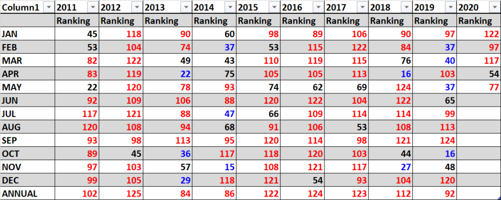
Later this month the National Center for Environmental Information will finish their assessment for Spring 2020, so our verification is not complete as of June 1st. Let’s do fill in ranking numbers with 1 being the coldest and 125 warmest for a verification for March and April, which have already been assessed:

I’ll complete the Spring 2020 verification for this post around June 7th when NCEI processes their numbers.
(Here is the completion from 6/10/20):
Here was my forecast for Spring 2020:
Here was my bottom line forecast for Spring 2020:
“I think that this spring will be ranked near that of the last four. Carbon pollution is definitely making below average seasons more rare. I’m going to guess that the Spring 2020 ranking will be around 100 + or – 10, with near average confidence given all of the factors in this post.” (Note that my forecast was on the too cool side by 20 ranking numbers for this winter.)
Not too shabby right?😃
It’s time for me to make an attempt at another seasonal forecast for temperatures for the lower 48 states. Summer is the most important season for temperature forecasting because heat during this time can turn deadly, particularly in this day and age of global warming. It’s important to give local authorities as much lead time as possible to make preparations for deadly heat that also, more often than not, is accompanied by drought for agricultural interests. Granted though, the state of long range forecasting for regional areas is not great, so only general forecasts can be made.
Well, here is my two cents for a broad, rough forecast for the U.S. First, I like to look at water temperature anomalies surrounding North America just before the start of a season to get a sense of how much potential added heat can be added to the atmosphere across the continent. Here is what we see:

Around most of North America, except in the Northeast, we do see above average Sea Surface Temperatures, which is one factor that would lead me to believe that Summer 2020 will see above average temperatures.
In the Pacific we don’t have an El Nino or a La Nino with ENSO in a neutral phase, which probably is in the process of going towards a La Nina. ENSO should not be a factor for warmth or chill in the U.S. this summer.
Second, I like to look at the strength of the Hudson Bay low or polar vortex at the start of any season:
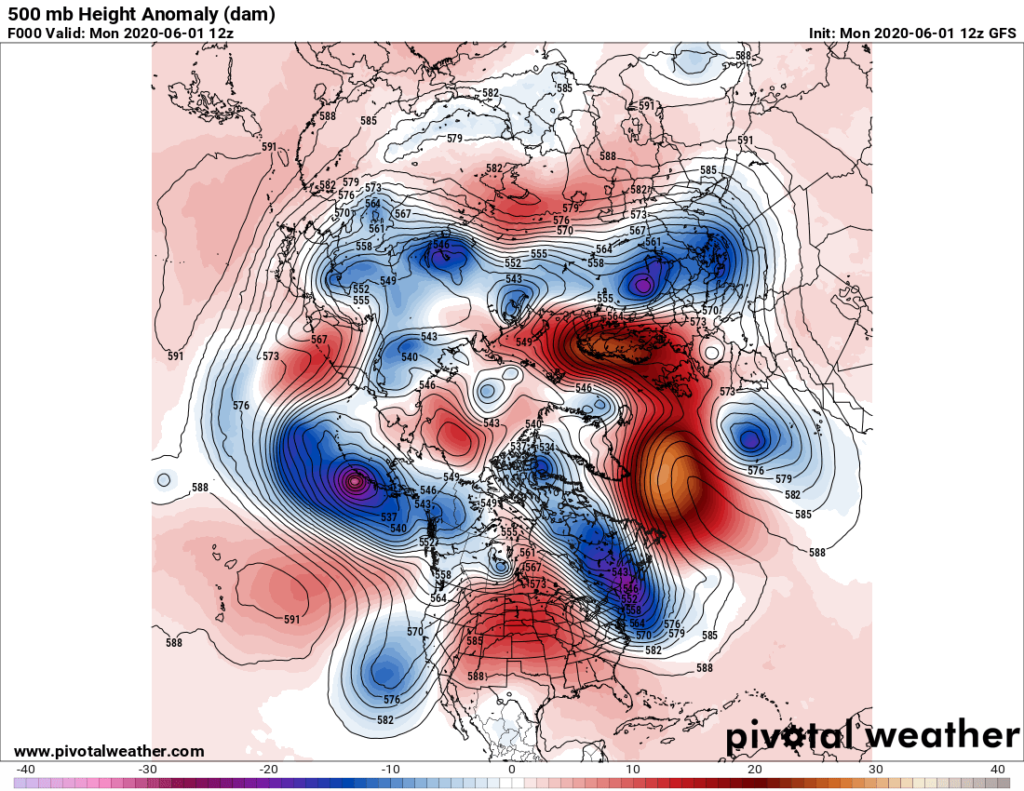
As of today it is elongated over Hudson Bay stretching southeastward into New England and definitely in tact. Yet another cold trough lies over the West with a stronger cold storm moving eastward south of Alaska. Such a pattern, if it continues, will lead to average or below average conditions in the north-central and Northeast. I suspect that near average to above average conditions may prevail elsewhere except in the West. We have seen a tendency for strong cold systems to move into the Pacific Northwest from the Gulf of Alaska, a pattern which should continue to produce chill for that portion of the U.S. well into the summer.
Here is the National Weather Service forecast for Summer 2020:

Unlike in my previous seasonal forecasting posts here I have many disagreements. I think that the NWS forecast is way too warm in the Pacific Northwest and Northeast, but about right across the rest of the country.
Overall, Summer 2020 will probably verify above average looking at trends from the rest of the planet.
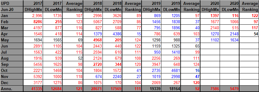
Last, we can get another clue looking at prior ranking and temperature record count data. For this I like to drag out that “Record Scoreboard” (updated through 5/30/2019):
Here we see clues that Spring 2020 started out warm in March, but there was a cooling trend going into April and May, which were colored blue because those months saw more daily low minimum records than high.
March was above average or “red” with many record reports coming into the National Center for Environmental Information system.
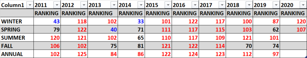
I expect a slight warming trend through August. June could be the coolest of the three months, relative average temperature wise, but all three months of summer should see an above average ranking of more than 62.5. (avg. rankings per year for the lower 48 states since 1895):
https://www.ncdc.noaa.gov/cag/national/rankings/110/tavg/202004
Not all seasons in the near future will see above average temperatures, but seasonal forecasters are beginning to”chuck it,” discounting colder than average scenarios due to carbon pollution.
Again, here are all seasons ranked for this decade:

Here is my bottom line forecast for Summer 2020:
“I think that this summer will be ranked slightly cooler that of the last four. Carbon pollution is definitely making below average seasons more rare. I’m going to guess that the Summer 2020 ranking will be around 90 + or – 10, with near average confidence given all of the factors in this post.”
Notice that the past five summers had a ranking at or above 101, but that of 2019 was the coldest relative to averages. The big El Nino of 2015/16 really spiked global temperatures as well as those for the U.S. From Fall 2018 through most of 2019 U.S. averages have gotten considerably lower than the torrid levels of 2016, though. Will increased global heat once again be a catalyst, helping to produce another “heat spell” or two during summer for the United States, causing my relatively cool forecast to bust? We will see.
As of 2020 the top ranking for any month or season would be 126 since climatological rankings for the United States started in the year 1895. I think that this summer will be ranked at least as high as 90. Carbon pollution is definitely making below average seasons more rare. As stated, I’m going to guess that the Summer of 2020 ranking will be around 90 + or – 10, but with average confidence given all of the factors in this post.
We will see how this forecast pans out around September 7th.
Here is more climate and weather news from Monday:
(As usual, this will be a fluid post in which more information gets added during the day as it crosses my radar, crediting all who have put it on-line. Items will be archived on this site for posterity. In most instances click on the pictures of each tweet to see each article. The most noteworthy items will be listed first.)
Here are some hot “ET’s” from the Northern Plains reported on Monday:
Now here are some of today’s articles and notes on the horrid COVID-19 pandemic:
(As usual, the most noteworthy items will be listed first.)
(If you like these posts and my work please contribute via the PayPal widget, which has recently been added to this site. Thanks in advance for any support.)
Guy Walton “The Climate Guy”