The main purpose of this ongoing blog will be to track planetary extreme, or record temperatures related to climate change. Any reports I see of ETs will be listed below the main topic of the day. I’ll refer to extreme or record temperatures as ETs (not extraterrestrials).😉
Main Topic: Thursday Update On Heatwave Apothis
Dear Diary. Unlike the Saffir-Simpson method for naming organized tropical systems, my naming of heatwaves can be somewhat deceptive. A bad, active Atlantic tropical season can be measured by the number of named systems for that particular year. A horrendously hot summer across the United States may have just one named heatwave that lasts the entire season. A less hot summer may have several named heatwaves with some breaks.
Also, we have already seen with Heatwave Apothis that the system has gotten up at least briefly to a CAT4. During a cooler summer we may have several unnamed heatwaves that get up to CAT2 or a few named ones that get up to CAT3. Back during 1980 we did see CAT5 criteria since that summer over a thousand people perished during an episode that lasted the entire season. So indeed, using my criteria, those summers with one or two prolonged named heatwaves that have rankings of four or even fives can be judged as much worse than cooler summers with multiple named CAT3 systems.
Too, we had a fairly localized CAT5 system named Beta in the Pacific Northwest last year. About half the nation east of the Rockies had a fairly typical summer, heat wise:
It is possible to have a fairly small CAT5 heatwave, but I must write that Beta was the only time I have ever witnessed such.
In any case, it’s time for an update on Apothis, which unfortunately looks like it will become truly historic for its longevity for Summer 2022.
As of Thursday, here is what we have as far as National Weather Service heat advisories and warnings go:
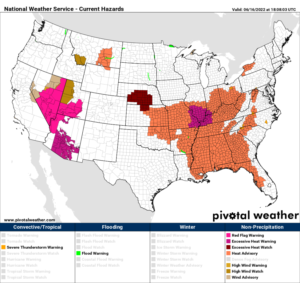
There is some good news here. For the last two days Apothis was a CAT4 because warnings extended far northward into the Midwest:
In my estimation, today Apothis is down to a CAT3 because most of the dangerous heat has been trimmed by a front out of the Great Lakes area. Also, most max readings will not cross the century mark today, another characteristic of a CAT4.
This is not to write that Apothis will dissipate. Far from that. The system will shift back to the Plains over the weekend then build back into the Southeast early next week:

There is a good chance that my hometown of Atlanta will see a rare 100°F reading or slightly higher sometime next week. Apothis unfortunately may turn out to be a big killer because of its longevity across the South. We will see.
Here is the latest Washington Post Capital Weather Gang article on Heatwave Apothis:
https://www.washingtonpost.com/climate-environment/2022/06/15/heatwave-midwest-east-record-highs/
Prolonged heat wave baking much of central, eastern Lower 48
The responsible heat dome is predicted to rebuild this weekend and deliver more record-challenging temperatures into next week

June 15, 2022 at 1:28 p.m. EDT

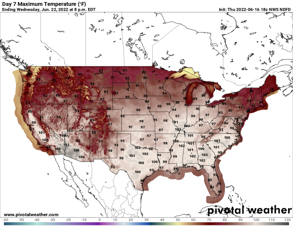
Predicted high temperatures over the Ohio and Tennessee Valleys on Wednesday. (Pivotal Weather)
A significant heat dome has been crowding weather maps over the Lower 48 states for the past week, bringing blistering temperatures that have toppled records. Highs have spiked 10 to 20 degrees above average in spots, and some places have endured their hottest and most humid weather ever observed during June.
10 steps you can take to lower your carbon footprint
Now the heat dome is languishing over the Tennessee Valley and bringing highs of 95 to 100 degrees from the Corn Belt to the Carolinas, with exceptional humidity in the Midwest exacerbating just how sultry it feels. High humidity levels are contributing to heat index values pushing 115 degrees in spots.
Yellowstone shuts down after record rainfall ravages roads
Because of the punishing combination of heat and humidity, more than 95 million Americans are under excessive heat warnings or heat advisories from the Florida Panhandle to northern Michigan.
Record-challenging highs are predicted Wednesday in Detroit, Chicago, Indianapolis, Columbus, Knoxville and Atlanta.
A new pulse of heat, meanwhile, is on the horizon and looks to become established into early next week. There are signs that the anomalously toasty temperatures could linger seven to 10 days or more, taking a toll on heat-stressed residents.
Notable records
Since the weekend, heat has expanded north and east while withdrawing from California and the Southwest, leading to a slew of record temperatures from the Plains to the Southeast. The ongoing episode is impressive not just for its exceptional daytime highs but associated elevated nighttime lows and sauna like humidity.
Here are a few of the more notable records collected from just the past two days:
- St. Louis had its warmest overnight low on record for June on Monday night into Tuesday morning. Temperatures didn’t dip below 83 degrees. A daily record warm minimum also was set Wednesday morning with a low of 81 degrees. St. Louis also hit 100 degrees on Monday, edging out the record of 98 set in 1952. Another record was snagged Tuesday with a high of 98 degrees.
- Kansas City, Mo., had a morning low of 81 degrees on Monday, which was the warmest in nearly 16 years there. At 4 a.m. on Monday, the heat index was still 92 degrees.
- Chicago (Midway International Airport)managed a high of 100 degrees on Tuesday, the earliest in the year it has hit the triple digits since 2012. The average high there in mid-June is 80 degrees.
- Milwaukee experienced its highest heat index in June since 1948. It reached 109 degrees at 3:52 p.m. Tuesday, tweeted the Maxar Weather Desk, the product of a 98-degree temperature and 73-degree dew point.
- Columbus, Ohio, recorded an unprecedented dew point, which is a measure of humidity, of 84 degrees at 6:45 p.m. on Tuesday. Any dew point over 80 degrees is exceptionally sultry. According to the National Weather Service in Wilmington, Ohio, that dew point beat the previous record high by 3 degrees. Columbus also posted a heat index of 115 degrees on Tuesday — among its highest on record.
- Dodge City, Kan., posted a low temperature of just 83 degrees on Monday, its warmest minimum temperature ever observed in any month of the year.
- North Platte, Neb., soared to 108 on Monday, its highest June temperature on record.
- Additional records: Columbia, S.C., hit 103 degrees on Monday. Madison, Wis., set a record high of 96 on Tuesday. Nashville managed a 97-degree high on both Monday and Tuesday, tying one record and breaking another. The Music City also had a record-warm low on Tuesday morning at 81 degrees.
The record-setting warm overnight low temperatures, of which there have been many, are potentially even more dangerous than daytime highs. While groups vulnerable to heat may be able to escape to air-conditioned public environment like a mall, shopping complex, library or public cooling during the day, they may not have access to cooling at night. That is especially true for those in challenging financial situations.
When overnight temperatures remain hot, the human body is deprived of its natural cool-down window and doesn’t have an opportunity to reset before daytime heat returns. That accumulated heat stress can be deadly for vulnerable individuals.
Before the heat spread into the central and eastern states, a slew of records occurred last week and over the weekend from Texas to California’s Central Valley. Death Valley, Calif., soared to 123 degrees on Friday while, over the weekend, Phoenix hit 114 and Las Vegas climbed to 109. Weekend highs peaked at 105 degrees in Austin and San Antonio.
The heat to come

Dozens of other records are in jeopardy Wednesday, with triple-digit heat expected in Atlanta and Columbia, S.C., while Chicago is predicted to soar into the mid- to upper- 90s. Nashville could flirt with 100 degrees, and mid- to upper-90s are likely virtually everywhere across the South.
The heat is forecast to continue Thursday, with Nashville around 100, northern Florida in the upper 90s, southwest Kansas in the lower 100s; and Houston with a high around 98.
A cold front will bring some relief to the Upper Midwest, Great Lakes and Ohio Valley on Thursday, along with the chance of some severe thunderstorms. But, by Friday, the next wave of heat will be building back to the northwest with temperatures in the 90s expanding into Montana.

The heat dome is predicted to intensify again over the weekend in the Central states, bringing a surge of record-challenging high temperatures to the central and northern Plains. By early to the middle of next week, the excessive heat will be on the move toward the Upper Midwest and Ohio Valley, and possibly the East Coast.

By Matthew Cappucci Matthew Cappucci is a meteorologist for Capital Weather Gang. He earned a B.A. in atmospheric sciences from Harvard University in 2019, and has contributed to The Washington Post since he was 18. He is an avid storm chaser and adventurer, and covers all types of weather, climate science, and astronomy. Twitter
Here are some “ET’s” recorded from around the planet the last couple of days, their consequences, and some extreme temperature outlooks:
Here is more May 2022 climatology:
Here is more climate and weather news from Thursday:
(As usual, this will be a fluid post in which more information gets added during the day as it crosses my radar, crediting all who have put it on-line. Items will be archived on this site for posterity. In most instances click on the pictures of each tweet to see each article. The most noteworthy items will be listed first.)
(If you like these posts and my work please contribute via this site’s PayPal widget. Thanks in advance for any support.)
Guy Walton “The Climate Guy”