The main purpose of this ongoing blog will be to track planetary extreme, or record temperatures related to climate change. Any reports I see of ET’s will be listed below the main topic of the day. I’ll refer to extreme or record temperatures as ET’s (not extraterrestrials).😉
Main Topic: 1st Update on American Heatwave “Chua”
Dear Diary. The old Climate Guy is pulling out his hair trying to keep up with reports and forecasts from Europe, North America, and elsewhere concerning anomalous record heat. What’s seared into my brain (pun intended) is this all could have been prevented if climate scientists had been taken seriously by presidential administrations from the 1980’s and 1990’s, but here we are.
I’m hoping that Biden will declare a climate emergency after record heat spurs more people in the general public to demand action:
Today let’s update information concerning domestic Heatwave Chua (named for a snakelike dragon from Hopi Indian lore) for our main topic.
Chua has drastically strengthened from Sunday. It’s now a high end CAT3 using my ranking criteria looking at the extent of heat advisories and warnings from the Plains:
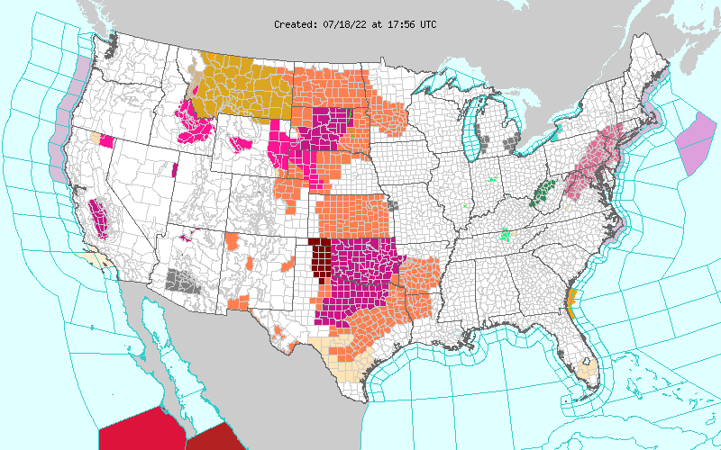
(My Pivotal Weather chart of National Weather Service advisories was not shown, but I’ll replace the above chart when it becomes available.)
What’s disturbing is that the heat dome in association with Chua was not that impressive this morning:
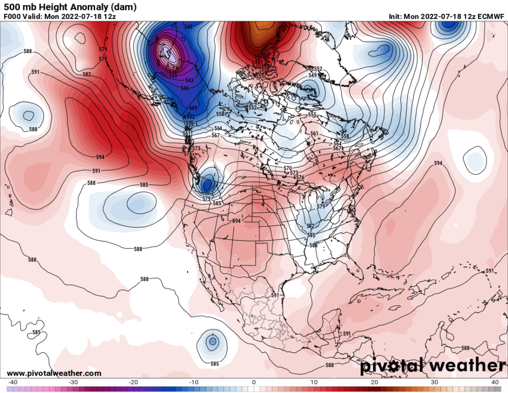
The nose of the 500 millibar heat dome parked over the Southwest extended into the western Plains supporting dangerous heat levels at the surface.
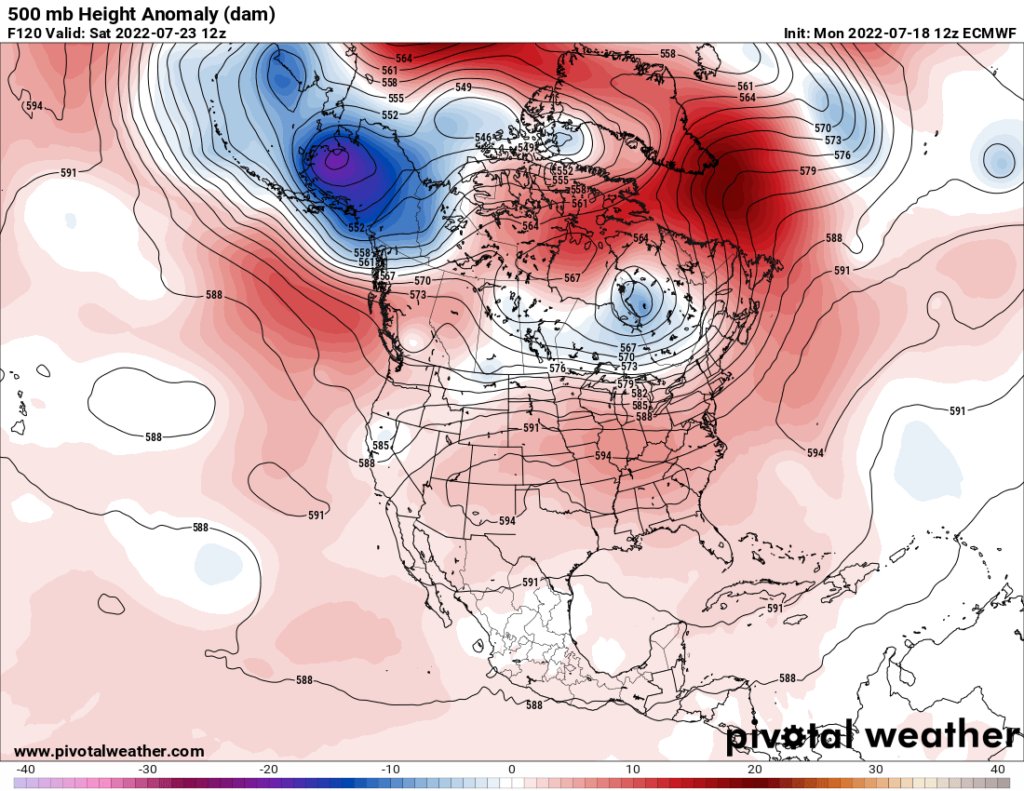
By next weekend the heat dome will have encompassed the southern 2/3rds of the United States, where blistering temperatures are expected:
If there is a light at the end of a hot tunnel, it may come from a cooling front in association with an Eastern trough, which may start to form early next week:
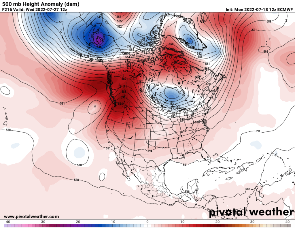
Despite a slightly weaker forecast heat dome, due to dry ground from our historic drought, I do expect many all-tine records to fall from Heatwave Chua.
The following is a report on Heatwave Chua made over the weekend from the Washington Post:
https://www.washingtonpost.com/climate-environment/2022/07/14/texas-oklahoma-heat-wave-plains/
Unforgiving heat wave in Texas and Southern Plains to worsen next week
Some areas already seeing their hottest summer on record are about to get hotter, with highs climbing to 102 to 110 degrees

Updated July 15, 2022 at 12:57 p.m. EDT| Published July 14, 2022 at 3:35 p.m. EDT

Forecast highs on Tuesday from the National Weather Service. (WeatherBell)
The temperatures in Texas and the Southern Plains are about to be turned up during an already historically hot summer.
Next week, some areas of interior Texas, Oklahoma and Kansas may see their highest temperatures yet, with predicted highs peaking between 102 to 110 degrees.
10 steps you can take to lower your carbon footprint
The core of the heat may concentrate along and just west of the populous Interstate 35 corridor, affecting San Antonio, Austin, Dallas, Oklahoma City and Wichita.
The heat will ratchet up just days after the Electric Reliability Council of Texas (ERCOT) twice issued conservation appeals (Monday and Wednesday), its power supply pushed to the brink. The state’s beleaguered grid is sure to be tested again.
A Texas meteorologist warned of power outages. Then the lights went out.
The heat will also worsen an intensifying drought over much of the Lone Star State, which has rapidly expanded into eastern Oklahoma and Arkansas.
The extreme heat, exacerbated by human-caused climate change, shows little sign of relenting through at least the end of July even as it waxes and wanes every few days.
How hot will it get and for how long?

The American modeling system shows a sprawling heat dome over the western and central United States on July 20. (WeatherBell)
Predictability is “high” for widespread heat in the central states between Sunday and Wednesday, the Weather Service writes. And it has declared a moderate to high risk of excessive heat as far out as the end of July.
Computer models show a heat dome or sprawling zone of high pressure centered near the Four Corners flexing eastward and not really budging for the next one to two weeks. The sinking air beneath these heat domes clears the air of clouds and allows the sun to beat down relentlessly.
The science of heat domes and how drought and climate change make them worse
The same areas underneath this heat dome are also affected by the expanding and worsening drought. The dry ground, sapped of moisture, heats up particularly fast.

Triple-digit highs are forecast for most of the area from Texas to Kansas through the weekend, before the hottest conditions arrive Tuesday and Wednesday. That’s when many areas along and just west of Interstate 35 could see highs close to 105 degrees — and possibly higher in some locations.
Some of this heat will also bleed into northern Louisiana, Arkansas and Missouri at times.
Here are current forecast highs for seven cities expected to see highs reach at least 100:
- San Antonio — Sunday: 101 | Monday: 101 | Tuesday: 102 | Wednesday: 103
- Austin — Sunday: 102 | Monday: 101 | Tuesday: 103 | Wednesday: 103
- Dallas — Sunday: 104 | Monday: 104 | Tuesday: 104 | Wednesday: 105
- Oklahoma City — Sunday: 102 | Monday: 104 | Tuesday: 107 | Wednesday: 105
- Wichita — Sunday: 98 | Monday: 101| Tuesday: 105 | Wednesday: 100
- Little Rock — Sunday: 95 | Monday: 97| Tuesday: 100 | Wednesday: 102
- Kansas City, Mo. — Sunday: 90 | Monday: 96 | Tuesday: 101 | Wednesday: 95
Computer models project temperatures could be several degrees hotter than this — flirting with 110 degrees in some places — but have shown a bias of being a bit too hot in their long-range forecasts.
National emergency in U.K. as historic heat wave sweeps over Europe
How hot it’s been in Texas

Temperature difference from normal in the Central United States averaged over the last 45 days. (WeatherBell)
The heat will pile on what’s already been a record-setting summer.
San Antonio, Houston, Waco and Austin are all having their hottest summers on record, with average highs between 98 and 102 degrees, or about 5 to 8 degrees above normal.
Here are some especially notable statistics:
- This is the hottest late spring and summer period on record in Texas using a metric known as population-weighted cooling degree days, which counts the number of degrees above 65, according MaxarWeather, a forecasting firm.
- Between Sunday and Tuesday, College Station saw three of its four hottest days (taking an average of the high and low temperature) since records began in 1888. The high temperature on Sunday of 111 was its second-highest on record.
- On Sunday and Monday, Houston saw its second- and fourth-hottest days on record, while San Antonio saw its second- and seventh-hottest days. Houston’s high temperature of 105 on Sunday tied its hottest on record during July.
- San Antonio has hit at least 100 degrees on 36 days this year, the most on record year-to-date. The city normally averages just three such days through July 13. San Antonio has reached the century mark every day this month.
The forecast calls for all of these locations to keep racking up triple-digit highs for the rest of the month, further separating the heat in 2022 from anything previously observed.

By Jason Samenow Jason Samenow is The Washington Post’s weather editor and Capital Weather Gang’s chief meteorologist. He earned a master’s degree in atmospheric science and spent 10 years as a climate change science analyst for the U.S. government. He holds the Digital Seal of Approval from the National Weather Association. Twitter
Here are some “ET’s” recorded from around the planet the last couple of days, their consequences, and some extreme temperature outlooks:
Here is more June 2022 climatology:
Here is more climate and weather news from Monday:
(As usual, this will be a fluid post in which more information gets added during the day as it crosses my radar, crediting all who have put it on-line. Items will be archived on this site for posterity. In most instances click on the pictures of each tweet to see each article. The most noteworthy items will be listed first.)
(If you like these posts and my work please contribute via this site’s PayPal widget. Thanks in advance for any support.)
Guy Walton “The Climate Guy”