The main purpose of this ongoing blog will be to track planetary extreme, or record temperatures related to climate change. Any reports I see of recently reported ETs will be listed below the main topic of the day. I’ll refer to extreme or record temperatures as ETs (not extraterrestrials).😉
Main Topic: Cold Outbreak Alpha to Affect Most of the Eastern Half of the U.S.
Dear Diary. With all of the anomalous hot weather happening across the United States and elsewhere that I’ve been reporting for the last few months, not many of you remember my pledge to give any cold weather its due. After all, warming global average temperatures due to anthropogenic climate change due not preclude atmospheric weather patterns when record cold can occur. A weather pattern across the eastern U.S. this week will definitely set some record chill:
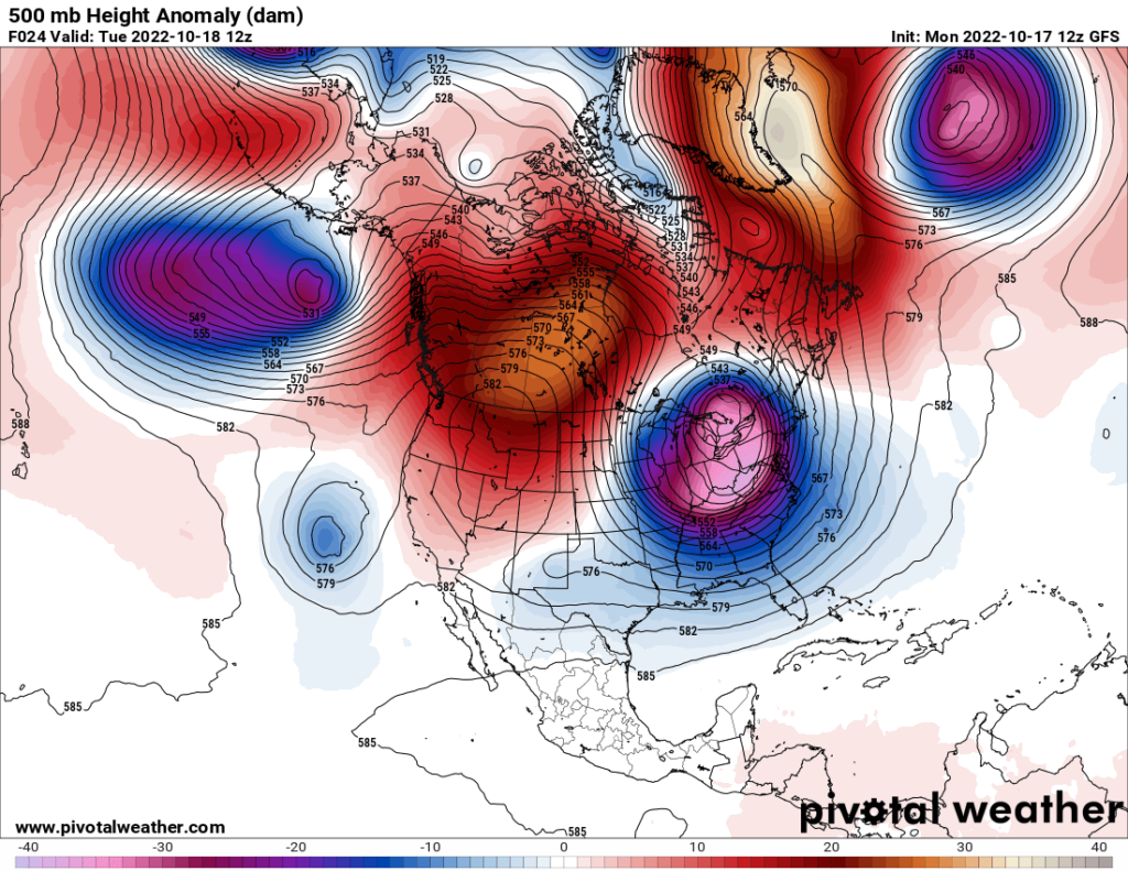
Anytime I see a cold vortex with 500 millibar heights an anomalously going into the purple zone on Pivotal Weather charts, surface record cold probably will be occurring.
You can read my initial post on this weather pattern here:
I already established some criteria for cold waves a couple of years ago. Here is that post:
Using Criteria from the November 2020 post, what we have is Cold Wave Alpha at Category two strength. I’m referring to this system as Alpha because the Weather Channel has not named an associated winter storm, although there will be some heavy lake effect snow around the Great Lakes. We should see hundreds of record daily lows go into the NCEI system, but life-threatening cold won’t be a thing this early in the season unless some poor souls are stuck outside without cold weather attire. Rather, temperatures will get as cold as the 20’s and 30’s above zero with wind chill getting down near zero in some Upper Midwest spots.
The National Weather Service has issued a wide swath of freeze and frost warnings for this cold outbreak:
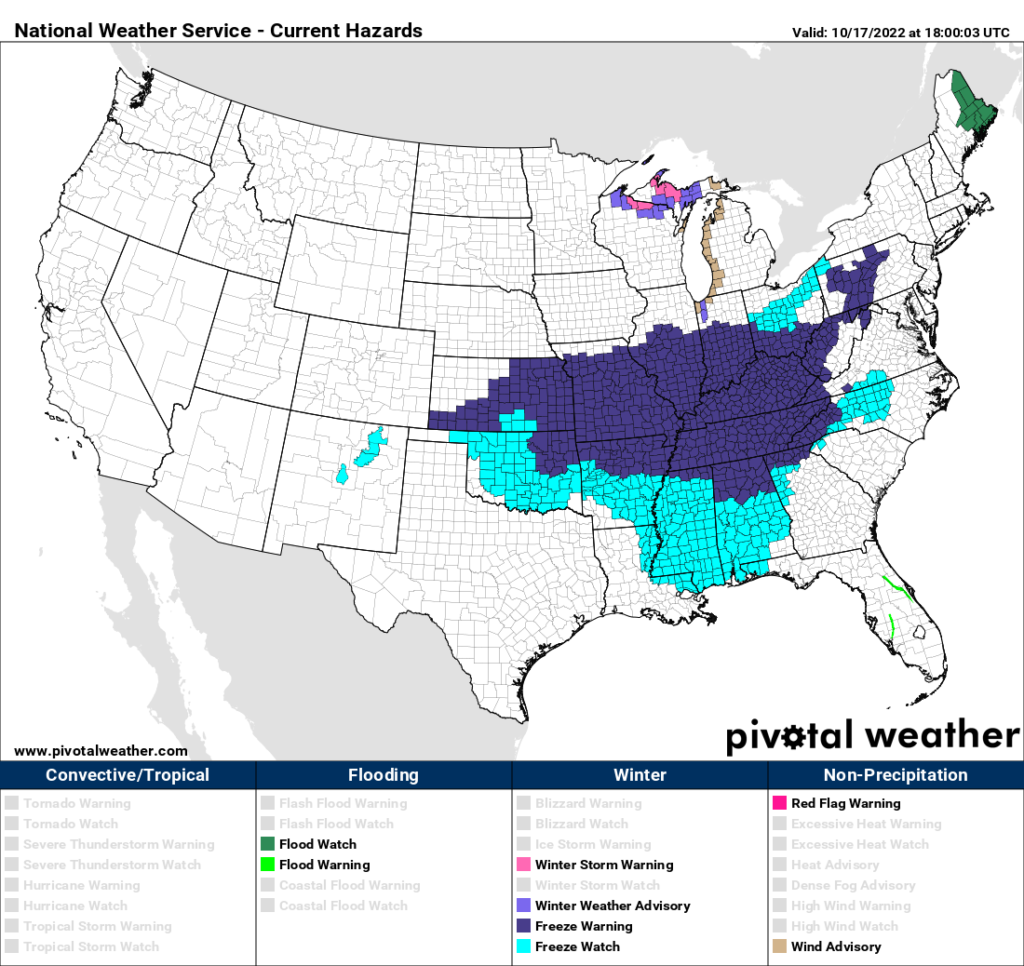
First freezes in the above blue area usually occur in early November, so these are about two to three weeks ahead of climatological averages.
I doubt that this cold outbreak will produce enough reports to get a month in which there are more daily cold records that warm, but looking at my most recent record scoreboard, we are about due for that:
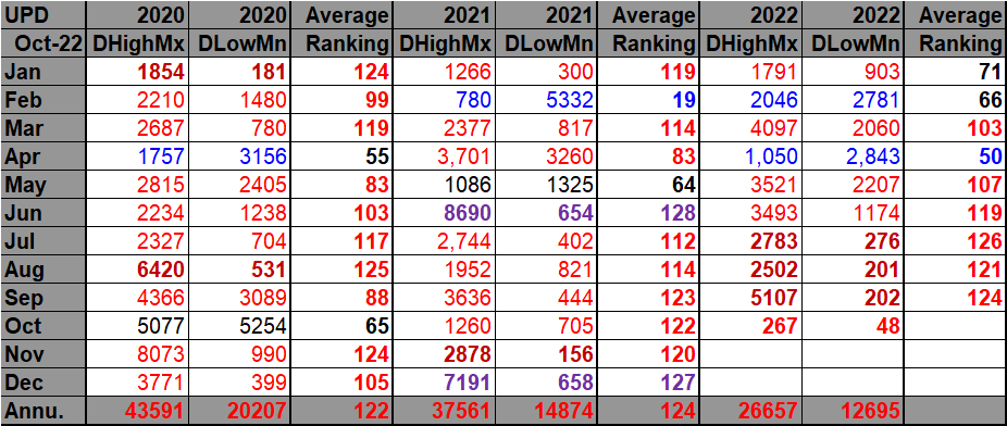
DHMX= Daily High Max Reports. DLMN= Daily Low Min Reports. DHMN= Daily High Min Reports. DLMX=Daily Low Max Reports.
It’s been five months since our last relatively cold month in April. We are coming off three consecutive very hot or “dark red” months on my chart, so we were due a cold outbreak that produces a less anomalously warm month.
The rankings are for the lower 48 states with the warmest ranking since 1895 of average temperatures being 128 (or 127 for a tie) and 1 being the coldest as of 2021. Blue colors represent cold months and red warm. Those months and years with counts close to a 1 to 1 ratio of highs to lows are colored black. Boldly red-, blue-, or purple-colored months, such as January 2020 and June 2021, have ratios of >10 to 1 daily record highs to lows or <1 to 10 daily record highs to lows, and are either historically hot or cold, most of which have made news. All-time record hot or cold ranked months are highlighted in purple.
This cold outbreak will only last a few days with the jet stream pattern dramatically shifting by next week:
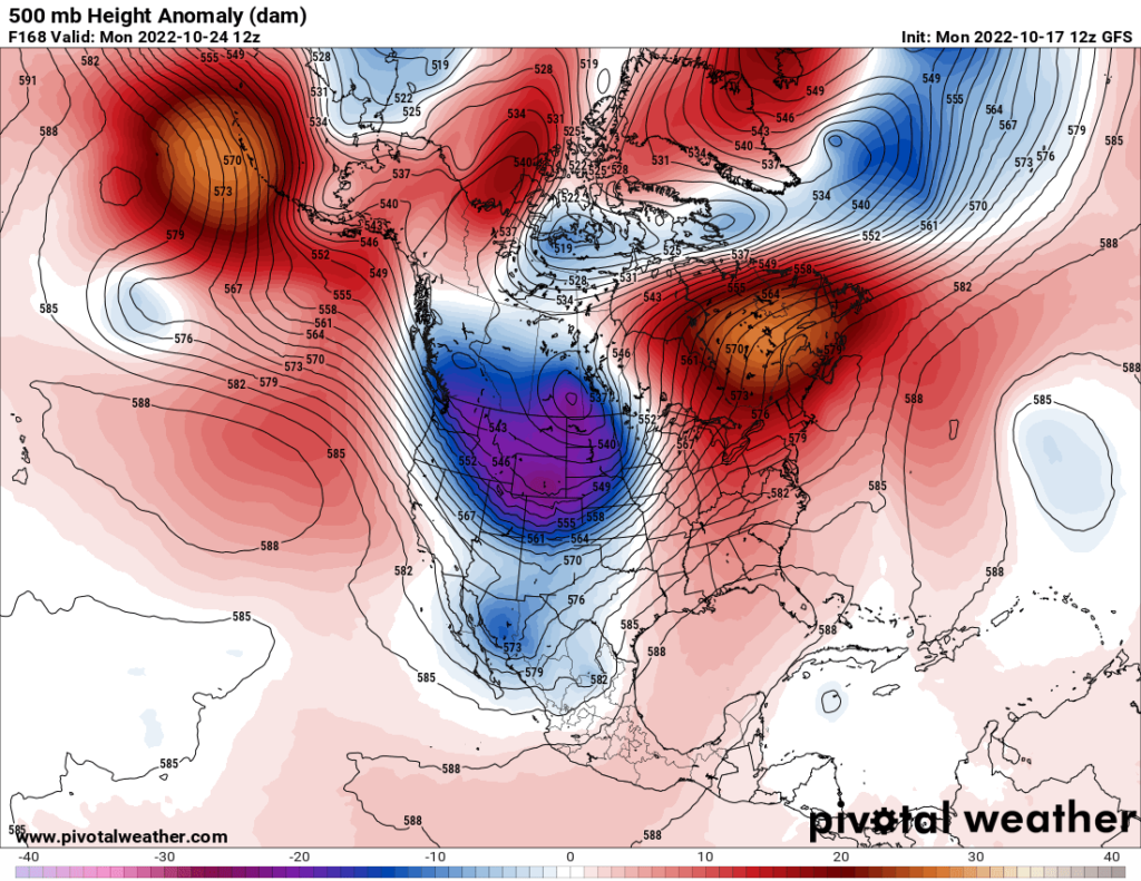
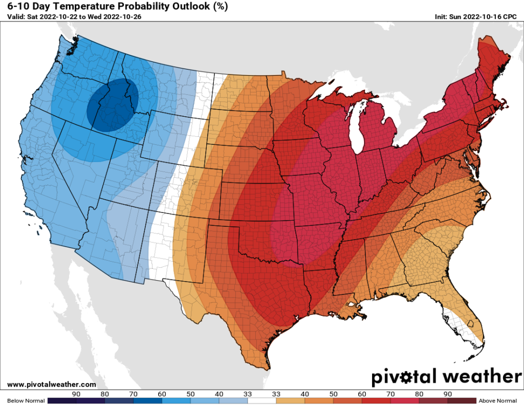
I would not be surprised to see record warmth occur in the same areas that will see record chill this week:
Here is a more detailed report on Cold Wave Alpha from my friend at the Washington Post, Matthew Cappucci:
https://www.washingtonpost.com/climate-environment/2022/10/17/cold-snap-eastern-us-snow/
Autumn cold snap to bring wintry feel, snow to some in Eastern U.S.
It’s the coldest air of the season so far, and many will even see their first snowflakes of the season

October 17, 2022 at 12:00 p.m. EDT

A pocket of cold air, low pressure and spin aloft over the Northeast and Great Lakes. (WeatherBell)
A blast of Arctic air is descending south over the Lower 48, bringing a wintry feel and temperatures 10 to 20 degrees below average to nearly 200 million Americans. In addition to the coldest air so far this autumn, many will even see their first snowflakes of the season. Accumulating snows are likely in parts of the Great Lakes, with up to 2 feet projected in the Upper Peninsula of Michigan.
Forty million people from Kansas to North Carolina are under freeze warnings, too, with another 40 million included in freeze watches or frost advisories. The early-season cold air outbreak will probably spell an end to the growing season and kill vulnerable or exposed plants.

Freeze watches and warnings from the National Weather Service. (PivotalWeather)
A few claps of thundersnow are even possible along the shores of the Great Lakes. Lake Erie, meanwhile, can anticipate scattered waterspouts as frigid air at the upper levels moves overhead.
The air mass has origins in the high Arctic north of Russia and Alaska, having spent the past week chilling over Canada en route to the Lower 48. The cold shot will last for three or four days, with a welcome reprieve coming as warmth returns next weekend.
How harsh will winter be? Six organizations issue forecasts.
In some areas, a garnish of fresh snowfall will decorate fall foliage nearing peak color, like in the Alleghenies and Appalachians. In the Upper Peninsula of Michigan, where a full-fledged snowstorm is ongoing, more significant snowfall will meet the fully leafed trees and cause damage and power outages.
What’s causing the cold

The NOAA GOES East weather satellite peers down on the low-pressure center near the Great Lakes. (College of DuPage)
The anomalously cool weather can be blamed on an upper-level low, or a pocket of high-altitude cold air, low pressure and spin nestled within a dip in the jet stream. It’s parked over the Great Lakes at present and will spend about 48 hours in place and strengthen. That counterclockwise flow will swirl down frosty Canadian air, spilling it all the way down to the Mid-South.
Using NOAA’s HYSPLIT model, which simulates the paths traced by parcels of air, meteorologists can conclude that the air mass wafting over the Great Lakes and Northeast actually was over Siberia on Oct. 10. Since then, it’s passed over the Chukchi Sea north of Alaska and through Canada, performing a small loop before sliding south near the Hudson Bay.
The stubbornly chilly air mass, with winds out of the west-northwest, will linger through Thursday.

Low temperatures Tuesday morning as predicted by the National Weather Service. (Pivotal Weather)
Temperatures will hover 15 to 20 degrees below average for days. In Minneapolis, breezy winds and highs around 37 are in the cards for Monday. The average is closer to 58 degrees. The next several days won’t be much better.
Chicago was heading for a high of 40 degrees for Monday, with the chance of a spot rain or snow shower in the afternoon. Tuesday and Wednesday will be in the mid- to upper 40s. Averages are closer to the lower 60s this time of year.
Indianapolis, Columbus and Detroit will spend several days in the 40s before a gradual warm-up late week. Nashville, Raleigh and Washington, which should be in the upper 60s to around 70, will be in the mid-50s midweek with lows in the 30s.
D.C.-area forecast: Blast of chilly air arrives Tuesday; warmer by weekend
A number of nightly low temperature records could be challenged or broken. Most areas across the Dakotas, Nebraska and Minnesota will fall into the teens or lower 20s on Tuesday morning, including Aberdeen, S.D., where a morning low of 10 degrees is expected. That would beat the record of 12 degrees set in 1930 and would also mark the coldest temperature to be measured this early in the season since 1937.
Who will see snow
Lake effect snows were piling up in the Upper Peninsula of Michigan, where forecast totals of up to 20 inches may be realized by early Tuesday. Cold air sweeping out of Canada was extracting heat and moisture from the relatively warmer waters of the Great Lakes — the perfect recipe for factory-like snow production. Winter storm warnings were in effect.
Snowfall totals in Marquette, Mich., could rank among the top 10 highest on record during October, with 4 to 10 inches predicted.
A winter weather advisory was also in effect for Porter and Jasper counties in Indiana, where a localized filament of lake-effect snow is possible. The National Weather Service in Chicago noted that “there is a higher than normal degree of uncertainty with the snow forecast.” Subtle changes in wind direction will have significant bearings on where the snow band materializes and drifts, assuming it does at all.
Significant accumulations of a half foot or more are possible along the eastern shores of Lake Erie, and particularly from Erie to Buffalo along Interstate 90. An isolated rumble of thunder can’t be ruled out.
Several waterspouts are also possible on Lake Erie itself thanks to converging, or gathering, winds and a sufficiently unstable atmosphere. Lukewarm water temperatures will create lift and encourage surface eddies to be vertically stretched by convective updrafts, or pockets of air that rise into individual storm cells.
A few inches of snow are possible atop the Tug Hill Plateau in western New York state as well. In addition, the western slopes of the Alleghenies in West Virginia and the Panhandle of Maryland might see a dusting to an inch or two of snow too due to “upslope snow,” or air carrying moisture forced up the mountains. A warm-up is expected around Friday.

By Matthew Cappucci Matthew Cappucci is a meteorologist for Capital Weather Gang. He earned a B.A. in atmospheric sciences from Harvard University in 2019 and has contributed to The Washington Post since he was 18. He is an avid storm chaser and adventurer, and covers all types of weather, climate science, and astronomy. Twitter
As always, I’ll put any reports I see of record chill in the space below:
Here are some “ET’s” recorded from around the planet the last couple of days, their consequences, and some extreme temperature outlooks:
Here is more September 2022 climatology:
Here is more climate and weather news from Monday:
(As usual, this will be a fluid post in which more information gets added during the day as it crosses my radar, crediting all who have put it on-line. Items will be archived on this site for posterity. In most instances click on the pictures of each tweet to see each article. The most noteworthy items will be listed first.)
If you like these posts and my work please contribute via the PayPal widget, which has recently been added to this site. Thanks in advance for any support.)
Guy Walton… “The Climate Guy”