The main purpose of this ongoing blog will be to track planetary extreme, or record temperatures related to climate change. Any reports I see of ETs will be listed below the main topic of the day. I’ll refer to extreme or record temperatures as ETs (not extraterrestrials).😉
Main Topic: Crippling U.S. Cold Wave on Tap for Christmas
Dear Diary. I have to keep stating over and over again that overall global warming does not preclude severe winter cold outbreaks. With time, these will become more rare and less cold, but as of 2022 still highly possible provided that we get the right jet stream pattern. Earlier this month we saw startling Arctic warmth, which is forcing cold pockets aloft southward towards mid latitude continental areas:
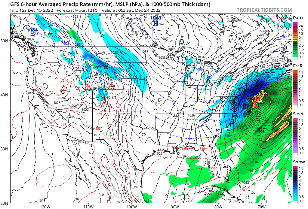
Fast forward to 12/15 and we are seeing meteorological forecasts models that indicate historic cold moving into the eastern U.S. by Christmas. In fact, if models are correct, we could see a top ten coldest Christmas Day on record for the lower 48 states.
Here is an ensemble model forecast showing the jet stream setup:

Notice two factors in the above Penn State Chart: 1) A combination of a ridge in the western U.S. with a deep trough in the East by 12/23. 2) Continue Arctic warmth looking at two big red pockets near the Arctic Circle.
This morning’s operational GFS was quite entertaining with a blizzard moving up the East Coast, starting where I live in North Georgia at Atlanta:
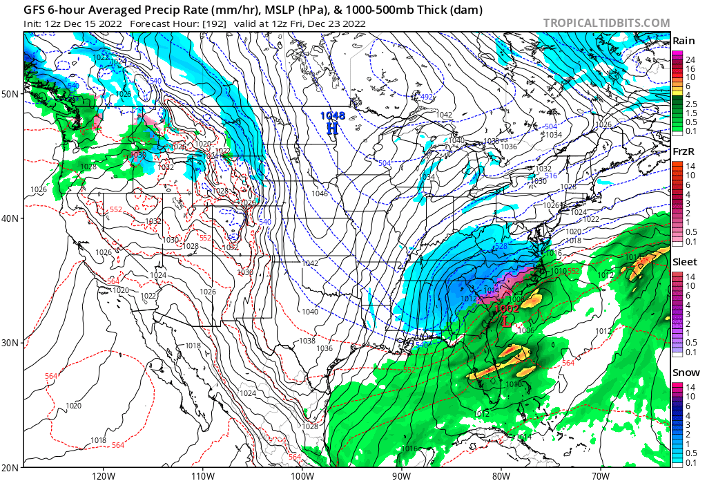
The above model scenario would cripple East Coast cities but delight kids wanting a White Christmas. A storm here in Atlanta is not likely at this time, but we will see. For other points north and east of Georgia a crippling storm is much more likely.
There are many factors over the next week that will determine how severe the East’s cold outbreak and associated storm will be:
Here is what other meteorologists are saying about this cold wave:
I’m anticipating a dangerous, historic CAT4 cold outbreak that will be named. Here are my latest criteria:
Now here is Ian Livingston’s assessment of the cold wave from 11/14/2022:
Arctic air is poised to unload on the Lower 48 leading up to Christmas – The Washington Post
Arctic air is poised to unload on the Lower 48 leading up to Christmas

December 14, 2022 at 3:08 p.m. EST

Extremely cold air may dump into the Lower 48 in the lead-up to Christmas. (weatherbell.com)
A pattern change that will eventually draw extremely cold air into the Lower 48 is underway.
The first blast of Arctic chill makes a brief visit behind the ongoing blizzard in the central U.S. As the calendar closes in on Christmas, more powerful bouts of frigid air are probable as air sourced from Siberia makes a beeline for the country.
At this point, it seems like atypical cold will also extend beyond Christmas, and potentially into the new year.
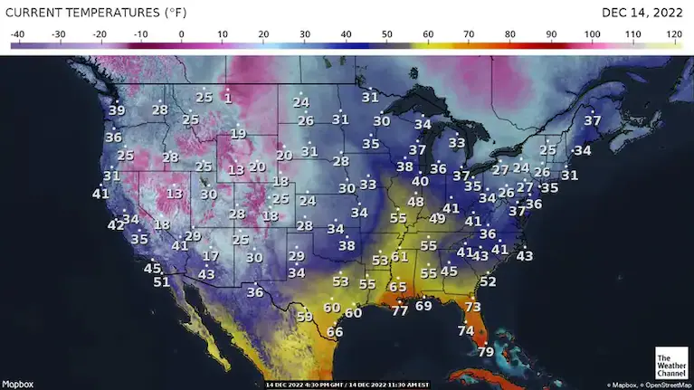
Temperatures during the midday Wednesday. (weather.com)
When looking for wintry air, there’s no need to wait. Maximum temperatures in the High Plains on Wednesday and Thursday in the teens and 20s are some 15 to 20 degrees below normal. That chilly air will migrate south and east this weekend, although its intensity will lessen some.
Storms turn deadly in South as blizzard swirls over Plains and Upper Midwest
By Saturday, high temperatures are forecast to be below normal over most of the Lower 48, except for parts of northern New England and the Great Lakes.
After a brief resumption of nearer average readings, computer model simulations project extremely cold air to pour into Montana, then fan out to the south and east next week. Temperatures in the northern Plains may only reach the negative single digits for highs by Monday, with single-digit highs encroaching on the Great Lakes by Tuesday.
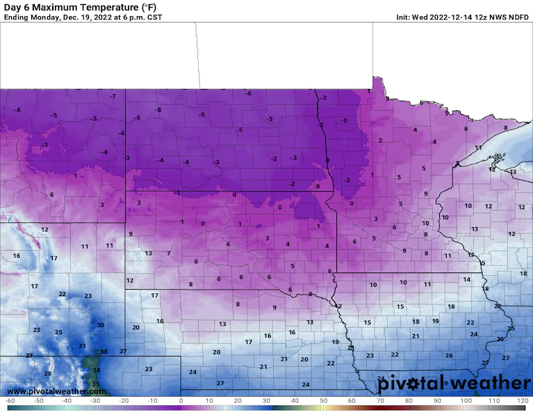
High temperature forecast from the National Weather Service for Dec. 19. (Pivotal Weather)
Even colder air may plunge southward as Christmas approaches.
Taking weather models verbatim — which is questionable so far in advance because of limited accuracy — high temperatures as cold as the teens and 20s will overtake the Northeast by the middle of next week. Some models show highs in the minus-teens and lows in the minus-30s or minus-40s across the northern Plains in the days leading up to Christmas. Lows in the 20s to near freezing could extend to the Gulf Coast if these projections are close to accurate.
There are a couple caveats: 1) Weather model projections have a cold bias at long ranges. 2) Some milder surges are also possible between cold shots.
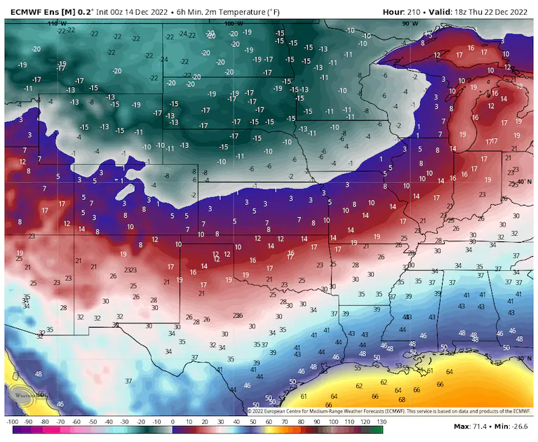
Low temperature forecast from the European ensemble model for the morning of Dec. 22. (weatherbell.com)
But confidence that the pattern will be cold is boosted by large groups of model simulations — or ensembles — which are in fairly good agreement that temperatures will lean sharply below normal. They advertise highs around minus-20 in North Dakota in the days before Christmas, which is more than 30 degrees below normal.
An advertised cold and snowy pattern in the eastern U.S. is delayed
For several weeks now, the large-scale pattern has also been highlighting the potential for some of the coldest air in the northern hemisphere to get jostled southward into the mid-latitudes.

Much of the Lower 48 is under a high or moderate risk of hazardous chill during the week of Christmas. (Climate Prediction Center)
Looking beyond the models and to the experts, the National Weather Service’s Climate Prediction Center projects most of the Lower 48 states will have below-normal temperatures both 6 to 10 days and 8 to 14 days from now. Most of the Lower 48 is also in moderate- to high-risk zones for “hazardous cold” in the days around Christmas.
The Climate Prediction Center even leans toward colder-than-normal conditions persisting through the three- to four-week time frame.
White Christmas odds are a bit higher than normal this year in D.C.
Ultimately, some cold temperature records may end up in play if the cold air blasts south as predicted.
But for now, even the very cold numbers forecast early next week across the northern tier fall short of historical records. It is a reminder that Arctic outbreaks of today are mainly milder than they were in the past because of human-caused climate change.

By Ian Livingston Ian Livingston is a forecaster/photographer and information lead for the Capital Weather Gang. By day, Ian is a defense and national security researcher at a D.C. think tank. Twitter
More:
Here are some “ET’s” recorded from around the planet the last couple of days, their consequences, and some extreme temperature outlooks:
Here is some more global November 2022 climatology:
Here is more climate and weather news from Thursday:
(As usual, this will be a fluid post in which more information gets added during the day as it crosses my radar, crediting all who have put it on-line. Items will be archived on this site for posterity. In most instances click on the pictures of each tweet to see each article. The most noteworthy items will be listed first.)
If you like these posts and my work please contribute via the PayPal widget, which has recently been added to this site. Thanks in advance for any support.)
Guy Walton… “The Climate Guy”