The main purpose of this ongoing blog will be to track planetary extreme, or record temperatures related to climate change. Any reports I see of ETs will be listed below the main topic of the day. I’ll refer to extreme or record temperatures as ETs (not extraterrestrials).😉
Main Topic: Could Arctic Warming Be Blamed for Bouts of Extreme Cold?
Dear Diary. Brrr! It’s the middle of Friday afternoon, and I’m shivering in Atlanta where it is currently 21°F with many across the United States experiencing the coldest readings in many years:
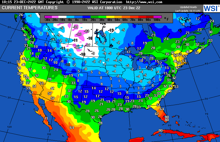
As many of you know who read this blog, cold outbreaks are becoming much rarer and aren’t lasting nearly as long as those from the 20th century and earlier due to climate change. I’ve witnessed this in my own hometown of Atlanta where a record long streak of days no colder than with a minimum temperature of 20°F was broken today:
This week’s occurrence of record chill will thankfully end well before the new year:
Record chill is also localized this time around North America. Europe is experiencing record warmth in some locations this week:
There is a hot debate for this cold time occurring among climate scientists, which I’ve recently touched upon, but the Washington Post has published an article on today? Could any residual extreme cold blasts be blamed on Arctic warming? Here is their writeup:
Is climate change triggering extreme cold? The debate is super hot – The Washington Post
Scientists say Arctic warming could be to blame for blasts of extreme cold
Research suggests that climate change is altering the jet stream, pushing frigid air down to southern climes more frequently. But the scientific jury is still out.

By Scott Dance
December 23, 2022
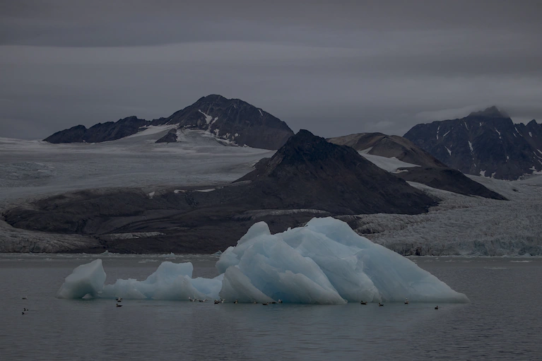
The Barents Sea along the coast of Norway in July. (Anadolu Agency/Anadolu Agency via Getty Images)
The data is clear: Rising global temperatures mean winters are getting milder, on average, and the sort of record-setting cold that spanned the country Friday is becoming rarer. But at the same time, global warming may be altering atmospheric patterns and pushing harsh outbreaks of polar air to normally moderate climates, according to scientists who are actively debating the link.
Drastic changes in the Arctic, which is warming faster than anywhere else on Earth, are at the center of the discussion. Shifts in Arctic ice and snow cover are triggering atmospheric patterns that allow polar air to spread southward more often, according to recent research.
“We’ve seen the same situation basically the last three years in a row,” said Jennifer Francis, senior scientist at the Woodwell Climate Research Center in Massachusetts. “Here we go again.”
But understanding any link between planetary warming and extreme cold remains a work in progress. Many climate scientists still emphasize that even if frigid air escapes the Arctic more often, winters will nonetheless become milder over time.
More than a million without power as frigid air overtakes eastern U.S.
The debate started with a research paper Francis co-authored in 2012. It gets revived whenever an extreme-cold event creates headlines, such as in 2021, when Texas’s energy grid was overwhelmed by a storm that killed 246 people.
Francis’s research hypothesized that Arctic warming was reducing the contrast between polar and tropical temperatures, weakening the jet stream, a band of strong winds in the upper atmosphere that helps guide weather patterns. A weaker jet stream would allow weather systems to more easily swing from the Arctic down into mid-latitude regions that typically have temperate climates.
Cold weather descends on Dallas on Thursday. (Emil T. Lippe for The Washington Post)
Since then, observations of jet stream patterns have not confirmed the hypothesis, said Daniel Swain, a climate scientist at UCLA. But the research inspired a flurry of follow-up studies that Swain expects will eventually clarify a link between climate change and cold-weather outbreaks.
“We’re 10 years into this conversation and there’s still a lot of mixed feelings in the scientific community, though there is some tantalizing evidence that there is some ‘there’ there,” said Swain, who works at UCLA’s Institute of the Environment and Sustainability.
A 2021 study published in the journal Science is one new point of debate. The research explains what author Judah Cohen called “a physical foundation” linking Arctic warming and changes in atmospheric patterns.
It focuses on the polar vortex, an area of low pressure typically parked over the North Pole and surrounded by a band of fast-flowing air. Cohen likens it to a spinning top — when the polar vortex is strong, that band of air spins in a tight circle.
Look out for falling iguanas as temperatures drop
Increasingly often, Cohen found, the polar vortex weakens like a wobbling top. That gives the circulating air a more oblong, extended shape and encourages bursts of Arctic air to spread southward.
While the polar vortex took on that stretched shape for about 10 days a year in 1980, in recent years, it has been occurring more than twice as often, said Cohen, director of seasonal forecasting at Atmospheric and Environmental Research.
The research links that to changes in the climate around the Arctic: In the Barents and Kara seas north of Russia and Scandinavia, the waters have warmed and ice has melted, whereas in Siberia, there’s been a cooling trend from increases in snowfall induced by climate change.
Some scientists say that a longer and more thorough record of data is needed to back up Cohen’s research and that there isn’t enough evidence to blame Arctic warming for cold outbreaks at lower latitudes.
The surprising reasons parts of Earth are warming more slowly
Swain predicted that scientists will make sense of the atmospheric dynamics but that it could take years.
“It’s one of the most complicated topics in climate science,” Swain said.
In the meantime, researchers are confident that cold extremes will follow larger global trends and gradually get warmer, though they still will have significant impacts on places unaccustomed to the cold.
“We’re going to break a lot of records this week, for sure,” Francis said. “The likelihood of breaking cold records is decreasing, and we see that in the data.”
And Cohen said data suggests that relief from the cold across the United States is near: Weather models agree that the polar vortex is going to snap back from its oblong shape by early January, trapping the most frigid air around the North Pole once again.

By Scott Dance Scott Dance is a reporter for The Washington Post covering extreme weather news and the intersections between weather, climate, society and the environment. He joined The Post in 2022 after more than a decade at the Baltimore Sun, where he most recently focused on climate change and the environment. Twitter
Now here are a few of the latest writeups from my friends at the Capitol Weather Gang on Winter Storm and Cold Wave Elliot (Many more can be found by hitting the following link.):
Winter storm live updates: Arctic blast snarls U.S. holiday travel – The Washington Post
Winter storm live updates…More than 1.4 million without power as frigid air overtakes eastern U.S.
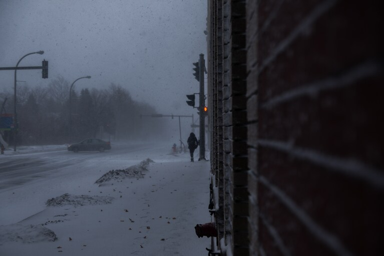
An image of a woman walking in the storm while a vehicle recovers after sliding. (Malik Rainey/for The Washington Post)
By Jason Samenow, Matthew Cappucci and Scott Dance
More than 1.4 million utility customers are in the dark Friday, as power outages spread across swaths of the country paralyzed by icy winds and blizzard conditions. The ice and snow are also upending plans for travelers during the busy holiday week: Flight cancellations had exceeded 3,600 on Friday.
Traffic had slowed to a crawl on roadways from Chicago to Nashville to Pittsburgh. In parts of New York and New Jersey, coastal flooding had inundated neighborhoods as local officials warn of significant challenges.
Here’s what you need to know:
- Severe blizzard conditions are underway in Buffalo, where heavy snow is falling, winds have gusted to nearly 70 mph and visibility has hovered near zero all day.
- Is climate change triggering extreme cold? Scientists say warming could be to blame for the cold blasts.
- Here are six maps that show the severity of the Arctic blast and winter storm.
Tennessee Valley Authority briefly imposes rolling blackouts to curb energy demand
By Scott Dance
The Tennessee Valley Authority briefly ordered utilities to impose rolling 30-minute blackouts Friday as extreme cold prompted what the agency called a “critical power supply situation” amid “unprecedented” energy demand.
The order was quickly rescinded, according to Memphis Light, Gas and Water — though utility customers were asked to continue conserving energy.
“We apologize for the inconvenience we know these conditions will cause, especially during a holiday period, but it is a necessary step to prevent far greater power interruptions affecting the entire area,” the TVA said in an alert on social media.
Temperatures were in the single digits to lower teens and wind chills dropped well below zero Friday across the authority’s service territory, which includes most of Tennessee and parts of Alabama, Georgia, Kentucky, Mississippi, North Carolina and Virginia.
It is the nation’s latest case of extreme weather straining power grids. In Texas in early 2021, a surge of Arctic air similar to the one spreading over the country this week overwhelmed the state’s grid and caused widespread and extended power outages; nearly 250 people died.
In California, extreme heat nearly forced rolling blackouts this summer, but voluntary energy conservation efforts helped avert a crisis there.
The TVA had ordered local power companies to cut their electricity load by at least 5 percent and up to 10 percent.
The Memphis Light, Gas and Water Division had warned its customers that would require it to impose 30-minute outages “up to two times a day on average,” and urged customers not to call with concerns unless outages lasted more than an hour.
To reduce power consumption, utility customers are asked to avoid using appliances such as dishwashers, clothing dryers and ovens and to turn off nonessential lights and appliances.
Denver notches second-coldest day on record
By Dan Stillman
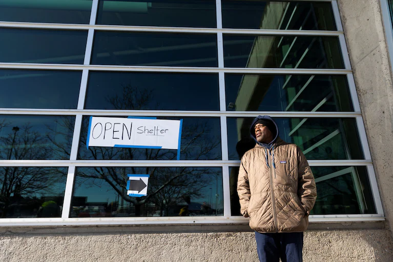
Laphonse McMillan stands outside of the Denver Coliseum during a period of cold weather in Denver, Colorado, U.S. December 22, 2022. The Coliseum opened its doors Wednesday afternoon to provide a warm shelter for the homeless. (Alyson Mcclaran/Reuters)
Denver should see temperatures rise above zero degrees Friday. That’s a significant improvement from Thursday, which clocked in as the city’s second-coldest day on record. Thursday’s high at Denver International Airport reached only minus-6 with a low of minus-24, good for an average daily temperature of only minus-15.
The coldest day on record was Jan. 11, 1963, with an average temperature of minus-17.
Wind chills made it feel even colder Thursday. The highest reported wind chill was minus-20 and the lowest was minus-40, for an average of minus-30.
Flight cancellations exceed 3,600 Friday
By Luz Lazo
Air travel disruptions continued for a third day Friday with more than 3,600 daily flight cancellations as a huge storm brings heavy snow, ice and severe cold to significant portions of the United States.
The past three days have brought headaches for airlines and passengers as more than 6,900 flights have been canceled since Wednesday, upending travel plans for millions of Americans headed for Christmas getaways.
The storm, striking during one of the busiest holiday travel seasons in more than two decades, is also creating dangerous conditions on the ground. Some long-distance and regional rail lines are closed through Sunday. Bus lines were suspended. State highway officials report closed freeways and severe crashes.
Conditions rapidly deteriorating in Buffalo, which faces storm ‘for the ages’
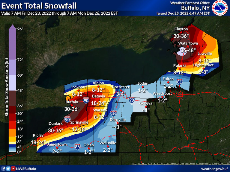
Buffalo snow forecast from the National Weather Service.
On Thursday, New York Gov. Kathy Hochul (D) declared the inbound storm for her state one “for the ages” — with Buffalo poised to bear the brunt. On Friday morning, the onslaught of snow and wind had begun.
At 9 a.m., Buffalo was reporting heavy snow, visibility of 0.13 miles, winds gusting to 64 mph, a temperature of 28 and a wind chill of 11. Just three hours earlier, it was raining and 38.
Webcams in the area revealed a virtual whiteout.
Buffalo is under a blizzard warning until 7 a.m. Sunday. The National Weather Service is predicting 2 to 3 feet of snow by then. The worst winds are expected through Friday night, when gusts could peak between 65 and 70 mph.
“Travel will be extremely difficult to impossible at times,” the Weather Service warns. “Widespread blowing snow will significantly reduce visibility. Very strong winds could cause extensive tree damage and numerous power outages. The bitter wind chills as low as 10 to 20 below zero could cause frostbite on exposed skin in as little as 30 minutes.”
As intense winds sweep over Lake Erie, its eastern shoreline around Buffalo is under a lakeshore flood warning for a rise in water up to 4 feet.
Dangerous flash freeze to strike Interstate 95 corridor

A high-resolution model simulation of the cold front’s timing. (WeatherBell)
Temperatures Friday morning were in the 40s along the Interstate 95 stretch in the Mid-Atlantic, with waves of rain and drizzle working north. The nation’s capital was at 45 degrees around 7 a.m., with Philadelphia at 49 and New York City sitting at a balmy 51.
An Arctic cold front — the one responsible for plunging most of the United States into a bitter deep freeze with wind chills below minus-10 degrees in two dozen states — was blasting across the Appalachians at the start of the workday. Said front will bring a dangerous flash freeze to the Acela corridor, dropping temperatures up to 25 degrees in three hours’ time and, in some cases, transforming rain-dampened roadways into sheets of ice.
Within two hours of the Arctic front’s passage, readings will be below freezing. This will spell a danger for commuters and holiday travelers. Exacerbating the risk even more is that crews were unable to pretreat the roadways due to rain. Also, roads that look wet may be deceptively icy.
In some places, strong winds may help dry off the pavement before it can freeze, lessening the flash freeze danger.
It’s important to check conditions before traveling between late this morning and this evening. Use particular care on bridges, ramps and overpasses that freeze first.
Here are some “ET’s” recorded from around the planet the last couple of days, their consequences, and some extreme temperature outlooks, as well as some extreme precipitation reports:
Here is more climate and weather news from Friday:
(As usual, this will be a fluid post in which more information gets added during the day as it crosses my radar, crediting all who have put it on-line. Items will be archived on this site for posterity. In most instances click on the pictures of each tweet to see each article. The most noteworthy items will be listed first.)
If you like these posts and my work please contribute via the PayPal widget, which has recently been added to this site. Thanks in advance for any support.)
Guy Walton… “The Climate Guy”