The main purpose of this ongoing blog will be to track planetary extreme, or record temperatures related to climate change. Any reports I see of ETs will be listed below the main topic of the day. I’ll refer to extreme or record temperatures as ETs (not extraterrestrials).😉
Main Topic: Record Hot Southern Asian Airmass Probably Will Strengthen Developing Cyclone in the Bay of Bengal
Dear Diary. As I’ve been reporting just about every week this spring, southern Asia has undergone a lot of eyepopping record heat due to our carbon pollution. Now it appears that an overall record hot airmass over the area will influence a developing cyclone in the Bay of Bengal, and steering currents will send the system into Myanmar (formerly known as Burma) or Bangladesh. The last few GFS model runs have a landfall in the province of Rakhaing sometime on Friday or early Saturday as a major CAT3 system:


The European model takes the system further north towards Bangladesh and is much slower, though:

Myanmar and Bangladesh are highly populated, so a strong cyclone moving into coastal areas there would be an absolute disaster…not that cyclones have moved into those countries before during their long histories.
I’m fairly confident that a strong cyclone will develop in the Bay of Bengal looking at the consistency of model forecasts within a 120 hour out timeframe.
Backing up in time to this Sunday, we do see a substantial heat dome over the area as noted by the red shading on this Pivotal Weather chart:

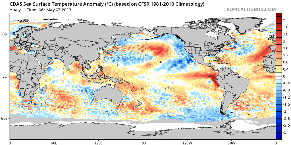
Let’s now check sea surface temperature anomalies in the Bay of Bengal:

Looking at the above chart, unfortunately they are very warm leading me to think that a big disaster is in the making. After all, cyclones (or hurricanes as they are known in the Atlantic) are the planet’s method for dissipating potential energy through kinetic motion.
Here are more records in association with this record warm airmass:
You can check out all of the past record reports coming from southern Asia on my past daily Diary blogs or on Maximilliano Herrera’s Twitter page @extremetemps. These records can be found under the following header:
Here are some more “ET’s” recorded from around the planet the last couple of days, their consequences, and some extreme temperature outlooks, as well as any extreme precipitation reports:
Here is some more brand-new April 2023 climatology:
Here is more climate and weather news from Sunday:
(As usual, this will be a fluid post in which more information gets added during the day as it crosses my radar, crediting all who have put it on-line. Items will be archived on this site for posterity. In most instances click on the pictures of each tweet to see each article. The most noteworthy items will be listed first.)
And from the Weather Department:
If you like these posts and my work please contribute via the PayPal widget, which has recently been added to this site. Thanks in advance for any support.)
Guy Walton… “The Climate Guy”