The main purpose of this ongoing blog will be to track planetary extreme, or record temperatures related to climate change. Any reports I see of ETs will be listed below the main topic of the day. I’ll refer to extreme or record temperatures as ETs (not extraterrestrials).😉
Main Topic: Heatwave Citgo Sends Portland to An August Record of 108°F
Dear Diary. Today let’s concentrate on western CAT3 Heatwave Citgo for our main topic. Though it probably won’t get pegged as “historic” in nature, getting up to my CAT4 level or won’t be long lasting, it has produced some remarkable records, particularly in Oregon:
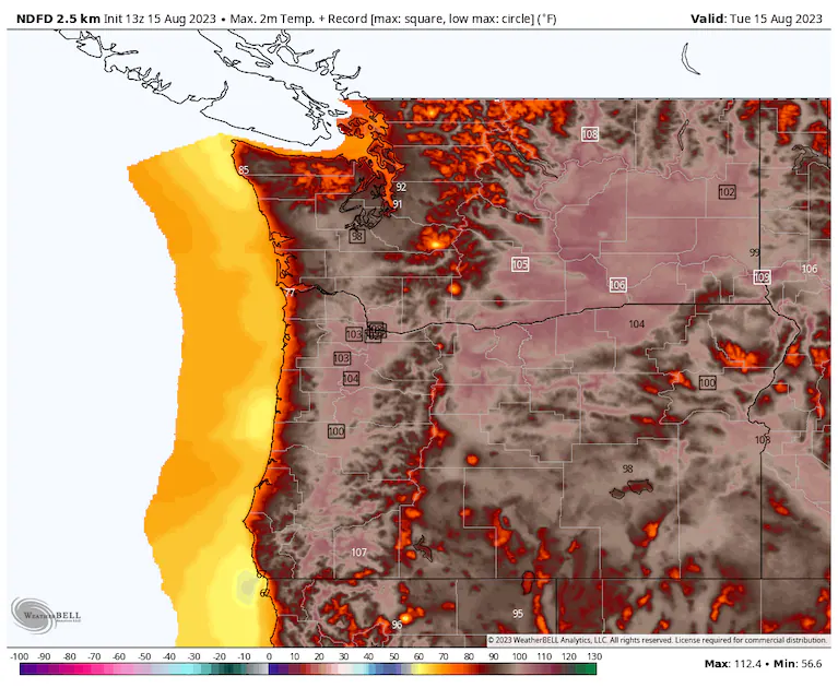
The 108°F reading at Portland broke the old daily record by 6°F and was a record for the highest reading recorded during the month of August.
As a reminder, here is this year’s criteria for naming and ranking heatwaves:
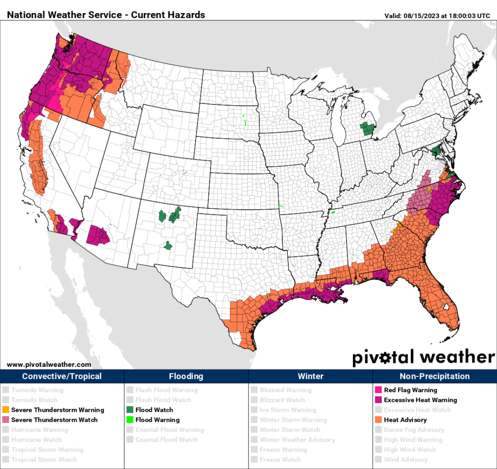
For the most part, heat is the only major weather player across the nation as of this Tuesday:

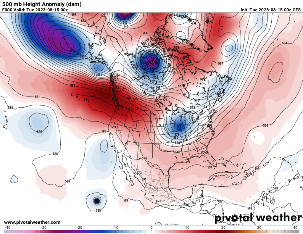
The heat dome in association with Heatwave Citgo will peaked on Monday and verified at about 596 decameters over the Pacific Northwest:

Notice this unusual weather pattern on the above Pivotal Weather chart. A 594+ decameter ridge stretched from the Pacific Northwest southeast through the Rockies and Texas into the Gulf Coastal area like a slithering snake. The southeastern part of the ridge was Heatwave Chevron’s heat dome. CAT4 Heatwave Chevron has been with us for most of this summer but should abate this week due to the passage of a cold front.
Heatwave Citgo also will be squashed due to its heat dome collapsing by Friday as a system moves southward from British Columbia, breaking the heatwave:

Here are more details from the Washington Post:
Pacific Northwest heat wave: Portland sets August record high of 108 – The Washington Post
Portland hits August record of 108 amid extreme Pacific Northwest heat wave

By Dan Stillman
Updated August 15, 2023 at 10:27 a.m. EDT|Published August 14, 2023 at 1:05 p.m. EDT

Forecast high temperatures on Tuesday. Temperatures surrounded by squares represent potential record highs. (WeatherBell.com)
After an intense early-season heat wave in May, the Pacific Northwest largely avoided the relentless heat that has plagued the southern United States this summer. That changed Sunday and Monday, though, as intense heat arrived in portions of Oregon and Washington state that is expected to last through much of the week, this time coinciding with the hottest time of the year.
Portland soared to 108 degrees on Monday, its highest August temperature on record and third hottest of all-time. It was among several locations in the Pacific Northwest that established August records.
Heat alerts cover all of Oregon and Washington and extend into northern and interior sections of California, as well. British Columbia’s South Coast is also under a heat warning. This week’s heat could rival last year’s week of blistering heat in the Pacific Northwest in late July and early August, but shouldn’t be as intense as the unprecedented, record-smashing heat wave of June 2021.
The interior valleys and lower elevations of western Oregon could have one of their hottest five-day stretches on record, the National Weather Service said, including Portland, Salem, Eugene and Medford. In Washington, the heat could come close to or break record highs during the next few days in Seattle, Spokane, Olympia, Yakima, Omak and Kennewick.
The humidity won’t be nearly as high as in the southern United States, where locations including New Orleans, Houston and Austin continue to dominate the hottest cities listed on The Washington Post’s heat tracker, but the heat will be dangerous nonetheless.
“Now is the time to begin to put your heat plans into action,” the National Weather Service said. “This is particularly true for anyone without reliable access to cooled and air conditioned locations, and anyone with plans for outdoor recreation. Have a way to limit your heat exposure and stay hydrated!”
In addition to its effects on people’s health and comfort, the heat will also elevate the fire threat in much of the region. Red-flag warnings for high fire danger are in effect for much of western Washington and Oregon. Evacuations were ordered late Sunday for the Lookout Fire east of Eugene, Ore.
Records already set, with more to come
Temperatures soared into the triple digits Sunday in northwest Oregon, including in Troutdale, where the high of 105 degrees broke the record for the date of 104 from 2002. Hillsboro tied its daily record high of 101. Portland’s high of 101 was one degree shy of a record, while Medford’s high of 106 fell two degrees short.
Several cities in Oregon including Portland, Salem, Eugene, Hillsboro and McMinnville set calendar day records on Monday, and in some cases all-time August records:
- Salem reached a high of 105 on Monday, beating its daily record high of 102 from 1942, but falling a few degrees short of the all-time August high of 108. High temperatures are expected to remain at or above 100 through Wednesday before a late-week cooling trend.
- Eugene reached a high of 103 on Monday, topping the record high of 101 in 2010, but falling short of the all-time August record of 108. High temperatures are forecast near 100 Tuesday and Wednesday before gradually cooling late this week and weekend.
- Portland reached a high of 108 on Monday, its hottest August temperature on record and third-hottest all-time. The three other times Portland has reached 108 degrees or higher all occurred during the June 2021 heat wave. High temperatures are expected to remain near or above 100 through Wednesday before cooling later in the week.
- Hillsboro and McMinnville both reached highs of 107 degrees on Monday. Both were record highs for the date, and it was Hillsboro’s all-time hottest August temperatures.
- The heat won’t be terribly unusual for Medford, but it will be persistent with forecast highs of 104 to 110 degrees expected to tie or break the record high every day through Thursday. On Monday, it reached 111 degrees.
- Troutdale hit 110 degrees Monday, an August record and 9 degrees above its Aug. 14 calendar day record.
The heat is on in Washington state as well, with Yakima, Omak and Kennewick expecting highs around 102 to 108 through midweek. In Yakima, the forecast of high of 106 on Tuesday would break the daily record high of 103 from 2021. Likewise, the forecast high of 107 on Tuesday for Kennewick would break the daily record high of 104 in 2021. Seattle won’t be as hot, but tied its second-warmest low temperature on record Monday at 71 degrees, with forecast highs near 90 through Wednesday.
How does this heat wave compare with previous ones?
In some locations, the heat could be as intense and almost as long-lived as that seen about a year ago. But it won’t be as extreme as the historic heat wave of 2021.
The region’s most recent heat wave was in mid-May, when temperatures soared above 90 degrees — nearly 30 degrees above normal — in parts of Oregon, Washington and British Columbia. That heat wave was unusual for how early in the year it occurred, and it contributed to May’s historic number of wildfires in Alberta.
Last year’s heat wave, which arrived during the last week of July, produced record-long stretches of exceptional heat. Seattle experienced six straight days of highs at or above 90 degrees, while Portland saw a full week of consecutive days at or above 95 degrees. Medford reached 114 degrees during that heat wave, one degree below its all-time high.
The current heat wave is not expected to be as bad as the one in June 2021, which killed hundreds of people and was found by climate scientists to be virtually impossible without human-caused climate change. Seattle made it to 108 degrees during that heat wave, while Portland soared to 116 degrees. In Canada, the village of Lytton broke the national heat record with a high of 121 degrees, a day before a massive blaze engulfed the town.
Marine heat wave and influence of climate change
The land heat wave coincides with an intense marine heat wave just off the Pacific Northwest coast, where water temperatures have recently surged to nearly 9 degrees above normal, registering a Category 4 on NOAA’s marine heat-wave scale.
“Large marine heatwaves have occupied the eastern north Pacific Ocean for much of 2023,” the National Oceanic and Atmospheric Administration said, but have remained far offshore until recently. The current marine heat wave is one of several occurring worldwide.
Human-caused climate change is making both marine and land heat waves larger and more frequent, intense and prolonged. For example, climate change is making this week’s heat in Oregon and Washington at least 3 to 5 times as likely, according to Climate Central’s Climate Shift Index.

By Dan Stillman Dan Stillman is a meteorologist and editor for the Capital Weather Gang. He earned an M.S. in Meteorology from Texas A&M University, and a B.S. in Atmospheric, Oceanic and Space Sciences from the University of Michigan. Twitter
Here are some “ET’s” recorded from around the planet the last couple of days, their consequences, and some extreme temperature outlooks, as well as any extreme precipitation reports:
Here is some more new July and August 2023 climatology:
Here is more climate and weather news from Tuesday.
(As usual, this will be a fluid post in which more information gets added during the day as it crosses my radar, crediting all who have put it on-line. Items will be archived on this site for posterity. In most instances click on the pictures of each tweet to see each article. The most noteworthy items will be listed first.)