The main purpose of this ongoing blog will be to track planetary extreme, or record temperatures related to climate change. Any reports I see of ETs will be listed below the main topic of the day. I’ll refer to extreme or record temperatures as ETs (not extraterrestrials).😉
Main Topic: Relentless Torrid Conditions From Heatwave Conoco
Dear Diary. Let’s get morbid for a second. The heat in associated with the system I’ve dubbed Heatwave Conoco (Phillips) is at such a high level and is so widespread that should power go out across a grid for a few days there will be thousands of fatalities. It’s likely that a few hundred outdoor workers will perish regardless of electric grids staying on from this well above average heat of August, but it will be tough for assessors to finalize this statistic for a few months. In any case (and fingers crossed) there is good news. The national electric grid and air conditioning technology has come a long way since 1995 when a heatwave killed hundreds in Chicago…what I would term as a good example of a CAT4 heatwave. A recent CAT5 heatwave named Beta from June 2021 did kill well over a thousand people across the Pacific Northwest and British Columbia, which will spur residents of those areas to get new air conditioning systems.
So back to Heatwave Conoco. Its heat dome, which peaked on Monday and Tuesday, certainly warrants CAT5 status:
I’m toying with the idea of declaring Heatwave Conoco a CAT5 today. Certainly, before the advent of AC in the mid 20th century, it would have killed thousands. I may adjust my criteria based on the extent of a heat done and severity of its associated heat. And yes folks, to improve science I can be persuaded by any arguments you as my readers might have.
In any case, here is the most recent summary on Heatwave Conoco from the Washington Post:
Extreme heat wave reaching its peak, especially in Midwest and Gulf Coast – The Washington Post
Extreme heat wave reaching its peak, especially in Midwest and Gulf Coast
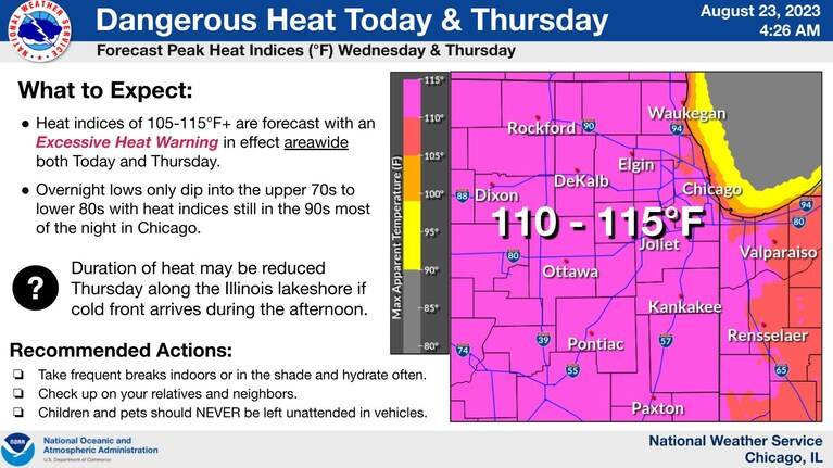
Chicago is forecast to approach 100 degrees both Wednesday and Thursday

August 23, 2023 at 11:28 a.m. EDT

Temperature forecast compared to average Wednesday afternoon. (Pivotal Weather)
An ongoing monstrous heat wave is reaching its peak as more than 110 million Americans find themselves under risk from dangerous heat indexes Wednesday. Record temperatures are set to focus on the Midwest and Gulf Coast region Wednesday and Thursday, before returning mainly to the South and toward Texas by Friday and Saturday.
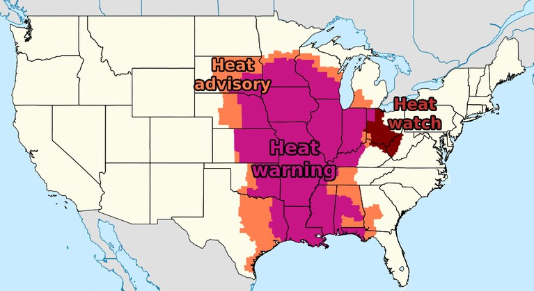
Excessive heat warnings are in effect for parts of 19 states, including all of Iowa, Missouri, Arkansas, Louisiana and Illinois. Areas under excessive heat warning can anticipate heat index values near and past 110 degrees, along with actual temperatures above 100.
Heat warnings are surrounded by heat advisories or heat watches on all sides. When combined, about 130 million people are under heat alerts.
“It is imperative to take the heat seriously and avoid extended time outdoors, as temperatures and heat indices will reach levels that would pose a health risk,” wrote the Weather Prediction Center. It noted that heat may be “potentially deadly to anyone without effective cooling and/or adequate hydration.”
Following another day full of record highs and record warm lows Tuesday, several hundred additional records are a good bet in days to come.
Extreme heat expands eastward
Chicago is forecast to flirt with 100 both Wednesday and Thursday. If it manages to reach that mark, it would be the first since early July 2012, which is the third-longest streak on record without hitting 100 there.
Some of the record high temperatures forecast Wednesday and Thursday include:
- Shreveport, La.: 107 and 107
- Mobile, Ala.: 104 and 100
- Beaumont, Tex.: 102 and 106
- New Orleans: 101 and 99
- St Louis: 101 and 103
- Memphis: 99 and 101
In and around Louisiana, where 100s seem to be never-ending, this next week will be punishing. New Orleans is forecast to near or pass record highs every day through Tuesday, including four days with a forecast of 100 or higher. Natchitoches, in the north-central portion of the state, is forecast to hit 110 Thursday.
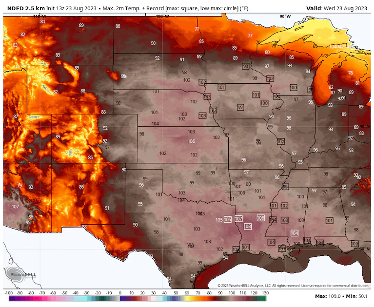
Numerous record highs are at risk Wednesday. (weatherbell.com)
Relentless heat keeps toppling records
Highs to 105 stretched from northern South Dakota to Central Texas on Tuesday, then eastward from there into Mississippi. Kansas, South Dakota and Nebraska saw temperatures as high as 108.
Record highs were set in the following locations, among many others:
- Salina, Kan., with a high of 107
- Lincoln, Neb., with a high of 105
- Baton Rouge, with a high of 103
- Meridian, Miss., with a high of 102
- Minneapolis, with a high of 98
Adding in the heat index, “feels like” values of 120 to 125 were common across the Midwest, in places such as Iowa and Missouri, where extensive croplands add to the moisture in the air. This follows Lawrence, Kan., surpassing 130 on Sunday and Monday.
Most long-term stations in Texas, Louisiana, along the northern Gulf Coast and into Florida are observing their hottest August on record, or close to it, according to the Southeast Regional Climate Center. For annual and summer tallies, it’s a similar footprint, but focused more on the Gulf Coast and Florida.
Warm nights
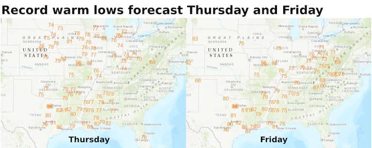
In addition to record highs, record warm lows have been falling by the hundreds, in part thanks to extreme humidity in addition to the high heat. Tuesday featured record warm lows from the Southeast to the Plains. Several cities well inland — Sioux Falls, Omaha, Tulsa and Memphis, among others — did not fall below 80 on Tuesday, and many probably will not Wednesday into Thursday.
Adding in the stifling humidity, plus urban heat island impacts, keeps it unbearable through the night.
“We don’t have heat indices falling meaningfully below 100 until after about 10 PM or so,” wrote the Weather Service in Chicago. Heat index values are probably “remaining in the upper 80s/near 90 for the bulk of the night.”
The low temperature Thursday might be about 80 in Chicago, which would be a record for the date. In Houston, record warm lows are forecast Thursday through at least Tuesday. The lowest temperature expected there is 80 through the stretch, with a few nights perhaps only making it to the mid-80s.
Lack of meaningful cooling at night significantly compounds health risks, especially for the poor and unhoused.
A break ahead?
Once into the weekend, heat is probably pushed southward to focus on the Gulf Coast. By next Tuesday, only a few record highs will be at risk. History says we might watch that tally rise as Tuesday approaches.
“The trend has been as high temps in the extended move into the mid to short term, numbers are added to them,” wrote the Weather Service in New Orleans.

Forecast for the final day of August shows high pressure focused over the 4-Corners region. (Tropical Tidbits)
It does appear that the most intense heat will shift westward to end August. Thereafter, it might shift back east during the first week of September.
In the current climate, the average final 100-degree day comes Aug. 17 in El Paso, Aug. 26 in Dallas and Aug. 31 in Austin, so time is at least historically running short in these areas. Hot spots out west, such as Phoenix, see 100-plus highs into October during most years.
More on extreme heat
Our warming climate: The ongoing heat wave is reaching its peak as more than 110 million Americans find themselves under risk from dangerous heat indexes. July was Earth’s hottest month, and here’s where the worst, record-setting heat occurred. Use our tracker to see your city’s extreme heat risk. Take a look at what extreme heat does to the human body.
How to stay safe: It’s better to prepare for extreme heat before you’re in it. Here’s our guide to bracing for a heat wave, tips for staying cool even if you don’t have air conditioning, and what to know about animal safety during extreme heat. Traveling during a heat wave isn’t ideal, but here’s what to do if you are.
Understanding the science: Sprawling zones of high pressure called heat domes fuel heat waves. Here’s how they work. You can also read more about the link between weather disasters and climate change, and how leaders in the U.S. and Europe are responding to heat.
More:
Here are some other “ET’s” recorded from around the planet the last couple of days, their consequences, and some extreme temperature outlooks, as well as any extreme precipitation reports:
Notes on the active tropics:
Here is more climate and weather news from Wednesday:
(As usual, this will be a fluid post in which more information gets added during the day as it crosses my radar, crediting all who have put it on-line. Items will be archived on this site for posterity. In most instances click on the pictures of each tweet to see each article. The most noteworthy items will be listed first.)