The main purpose of this ongoing blog will be to track planetary extreme, or record temperatures related to climate change. Any reports I see of ETs will be listed below the main topic of the day. I’ll refer to record temperatures as ETs (not extraterrestrials).😉
Main Topic: Historic CAT4 Cold Wave Jerry to Put U.S. In The Deep Freeze
Dear Diary. Given the law of averages and the fact that our basic climate isn’t broken beyond repair yet, the United States is having a big bought of winter weather this month after having a record warm December. However, this January’s winter weather is anything but typical. One winter storm this week dubbed by the Weather Channel as Finn has produced tornadoes over the Southeast, flooding rain from the Southeast into the Northeast and high winds toppling trees over the Northeast causing thousands to have power outages. It can be argued that extra heat put into the atmosphere from climate change caused Finn to become as strong as it was.
Now Gerry will be about as strong as Finn, if not stronger late this week and move across the same general area. Behind Gerry will come a severe Arctic outbreak not seen in years for some areas of the United States due to its intensity.
Good, bad, ugly 🥶 The temperature tumble expected for much of the country by this weekend into next week will make your bones ache just looking at these maps. @weatherchannel pic.twitter.com/pcF1WMS3yX
— Scot Pilié (@ScotPilie_Wx) January 10, 2024
Dr. Michael Mann and Dr. Jennifer Francis have posited that such an arctic outbreak is made more likely due to the weakening of the polar vortex because of warm air intrusions into polar areas at the jet stream level of the atmosphere. That science isn’t proven yet but given what I have witnessed as a meteorologist for decades, I would agree. Regardless, these arctic outbreaks are becoming rarer as our global warming trend continues.
Here is the link for my rules for naming cold waves:
Looking at the severity of Gerry, it is likely that the system will be a historic CAT4 and has the potential to be a real killer because some all-time record lows will be threatened in a few western and northern U.S. locations. It has been a while since I’ve seen thickness values below 498 decameters on surface charts, but that is indeed what is forecast late this week across the Upper Midwest:
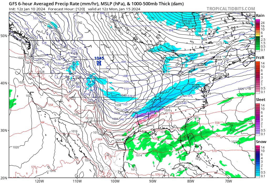
A near 1050 millibar Arctic surface high pressure cell will be driving record cold air south and east starting this weekend.
Aloft here is the forecast cold vortex in association with Cold Wave Jerry:
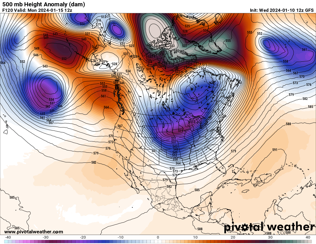
On the above Pivotal Weather chart one can see a Hudson Bay low slinging another chunk or lobe of the polar vortex southward, which is a typical setup for an Arctic outbreak that I have seen for many a moon. What is not typical is extreme polar warmth as noted by red and white anomaly colors on the chart. This warmth is forcing residual cold pockets southward over mid latitude areas.
Cold Wave Gerry will have a lot of fresh snow cover to move over from its storm component. Don’t forget that snow aids radiation of heat into space via its high albedo:
Median or middle-range of expected snowfall over next 3-days from powerful winter storm across the Great Lakes
— Ryan Maue (@RyanMaue) January 10, 2024
Large area of 12"- 15" of snowfall including Milwaukee, Chicago, and Grand Rapids.
Get your plows/snow blowers ready! pic.twitter.com/g6fAB4MO2B
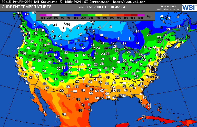
Today one can see below zero temperatures in association with Jerry building across western Canada. Outside of the most northern tier of states, the United States is having a relatively mild day ahead of an Arctic front marking the dividing line between cold and downright frigid conditions:
And here we find how cold it will be by Monday the 15th across the CONUS on the latest model run:
Average low temperature across the Lower 48 on Monday and Tuesday will be just under 8°F 📉from the Arctic blast
— Ryan Maue (@RyanMaue) January 11, 2024
Dallas probably will sink to around 8° to 10°F
Texas statewide average of around 14.5°F both days. pic.twitter.com/d7i3QrnKnm
Here are more details on Winter Storm Gerry and CAT4 Cold Wave Gerry from the Washington Post (Note- The Washington Post does not name these systems. I contend that the public would be better served if all “majorly defined” weather systems get names.):
Week’s third storm to charge across U.S. with another blizzard, tornadoes
The third storm in just six days may be the most intense amid an exceptionally active weather pattern

January 10, 2024 at 12:07 p.m. EST
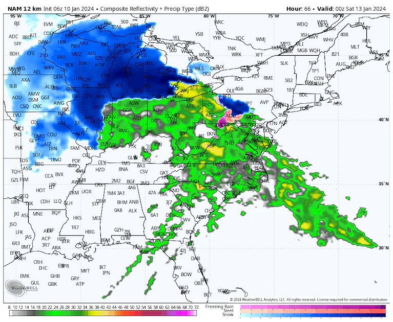
A simulation of the next storm system pummeling the Great Lakes with snow. (WeatherBell)
Back-to-back storms have already pummeled the Lower 48 states, bringing heavy snow, deadly tornadoes, flooding rains and power outages. More than a half-million customers in the eastern United States remained in the dark to start Wednesday after Monday and Tuesday’s high-impact storm.
Unfortunately, a third storm system is already beginning its march across North America, unleashing blizzard conditions in the Pacific Northwest. By Thursday, it’s poised to dive into the Plains and spread snowfall. That’s before it unleashes severe thunderstorms and tornadoes in the South and blizzard conditions in parts of the Upper Midwest and Great Lakes on Friday. A quick burst of heavy rain will also sweep across flood-prone areas of the Mid-Atlantic and Northeast late Friday into Saturday.
Like the storm that barreled across the central and eastern United States on Monday and Tuesday, this next cyclone will generate an enormous area of high winds that could trigger tens of thousands of power outages in multiple states. In fact, computer models project its pressure will drop faster than the early-week storm and that it will meet the criteria of a “bomb cyclone” because of its rapid intensification. Generally, the lower the pressure, the stronger the storm.
How the storm will evolve
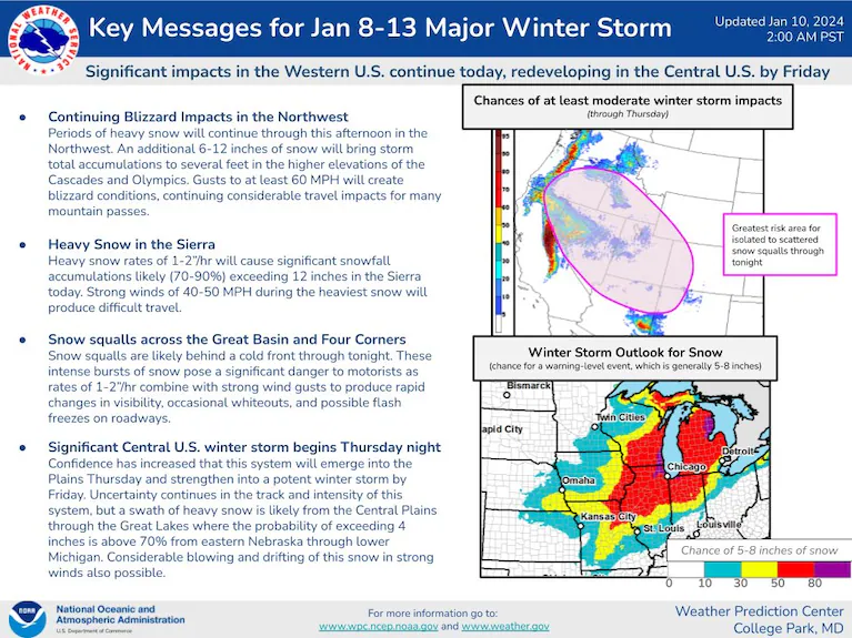
After ejecting from the Rocky Mountains on Thursday, the storm system will begin to intensify over the Plains. Severe thunderstorms will erupt on its warm side, first over Texas, Arkansas and Louisiana on Thursday before spreading into Alabama and the southeast on Friday. Both days could feature a tornado risk, with strong tornadoes not out of the question Friday.
On the system’s cold side, another swath of heavy snow falls in the Midwest from Thursday night to Friday night. The jury is still out on how much snow falls where, but St. Louis, Kansas City, Chicago and Detroit could see appreciable amounts. Where jackpot totals occur, a foot or more is possible. Fierce winds accompanying the snow could bring near-whiteout conditions for some.
On the storm’s back side, the coldest air of the winter will plunge into the western and central states this weekend, and heavy lake-effect snows could occur downwind of the Great Lakes, including near Cleveland and Buffalo.
Another winter storm could threaten the East Coast by the start of next week.
Pacific Northwest snow and wind
A strong system moving over the Pacific Northwest brings heavy snow and strong winds to the Cascades. pic.twitter.com/btloV6GiiI
— CIRA (@CIRA_CSU) January 9, 2024
Blizzard warnings were in effect in the Cascades until Wednesday evening, with winter storm warnings covering most of the remainder of Idaho and Oregon and even dipping into the northern Sierras in California. Snow levels in northern areas were reaching down to 2,000 feet, combining with strong winds topping 40 mph to reduce visibilities below a quarter-mile. Wind gusts could approach 75 mph in some of the highest mountain peaks. The high terrain of Northern California and the Great Basin of Nevada are in line for wintry weather, too.
Here are some of the peak totals through Tuesday night:
- Steven’s Pass, Wash: 30 inches
- Paradise, Wash: 19 inches
- Roslyn, Wash: 18 inches
- Snoqualmie Pass, Wash: 18 inches
- Dover, Idaho: 13 inches
- Mount Baker, Wash: 13 inches
- Elmira, Idaho: 12 inches
Up to about 10 inches of snow also fell over Washington’s Olympic Range closer to the coast, where a blizzard warning is in effect, as well. Another 3 to 6 inches is possible throughout the daylight hours Wednesday before the storm system withdraws to the southeast.
High winds have buffeted much of the region. In Kennewick, Wash., near the Oregon border, gusts up to 77 mph were recorded. In Seattle, winds gusted 40 to 50 mph, but gusts approached 70 mph at the coastline along the Strait of Juan de Fuca.
Potential blizzard for the Midwest and Great Lakes
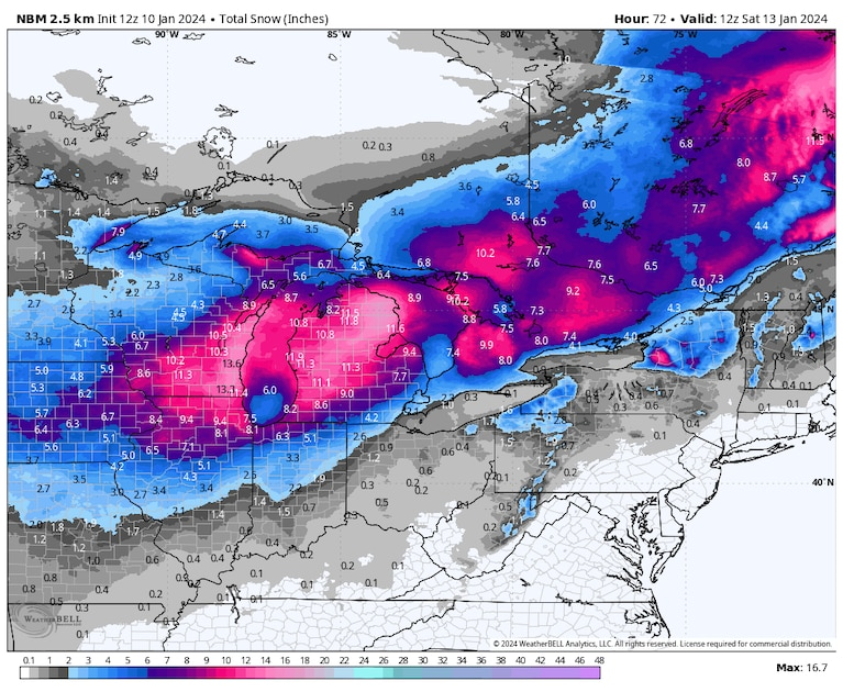
A computer model blend simulates how much snow could come down with the next storm. (WeatherBell)
It’s too early to know how much snow will fall as the same storm system spawns a new region of low pressure over the Plains, but it’s looking like a lot. Weather models are consistent in dropping a foot or more across the nation’s heartland, but they differ on the exact placement of the top totals.
Snow looks to break out over Kansas, Nebraska and/or portions of the Corn Belt on Thursday afternoon or evening. Then it increases in coverage and intensity while shifting northeast, reaching Chicago and perhaps Detroit on Friday. North of the rain-snow line, significantly more than a foot of snow isn’t impossible.
“Several inches of accumulating snow in combination with strong winds may result in difficult travel across the area into Saturday,” the National Weather Service in Chicago wrote, “although considerable uncertainty remains regarding the storm track and rain/snow line location.”
It’s possible that mild air off Lake Michigan cuts down on snow totals in Chicago, but much greater amounts fall just to its north and west.
Even after the storm passes, frigid air spilling southward over the Great Lakes will bring heavy lake-effect snow on downwind shores over the weekend.
“The pattern supports the possibility of significant snow amounts through the later half of the weekend for area east of the lakes,” wrote the Weather Service office serving Buffalo. “Additionally, windy conditions will persist throughout the weekend and support areas of blowing snow.”
Tornadoes in the South
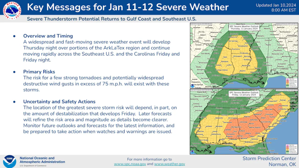
The same storm system will swing a combination cold front across the lower Mississippi Valley and southeast. Near the front, a swift change of winds speed and/or direction with height, fueled by a fierce jet stream dip, will encourage those thunderstorms to spin and produce tornadoes. Some of the strong momentum in the upper atmosphere could also be mixed to the surface in the form of damaging straight-line wind gusts.
The National Weather Service Storm Prediction Center has drawn a Level 2 out of 5 “slight” risk of severe weather over portions of Texas, Arkansas and Louisiana for Thursday. It includes cities in East Texas such as Tyler and Lufkin, as well as Shreveport in northern Louisiana and cities south of Little Rock.
Friday is more concerning. The agency has taken the unusual step of drawing a Level 3 out of 5 “enhanced risk” of severe weather three days in advance, accounting for what it warns could be “high winds and a few strong tornadoes.” The area stretches from near a line from Birmingham to Montgomery, Ala., east toward Savannah, Ga., and northeast through the Carolina Piedmont south of Raleigh, N.C.
It’s unclear which structure of severe thunderstorms will form. Rotating supercells with a couple of tornadoes are possible, or clustered storms more prone to producing straight-line winds could materialize. Either scenario would be problematic.
Heavy rain and strong winds in the East
Fortunately, it does appear that, for most areas in the southeast, this storm may feature less rainfall than several of the recent systems. That’s encouraging, since the ground is already so waterlogged from a month and a half of excessive rains. For the southeast, the convective nature of the rainfall, meaning more scattered in the form of thunderstorms and individual downpours, will lead to irregular and highly variable precipitation totals. Some spots might see only a half-inch of rain, while others get 2 or 3 inches in a short period.
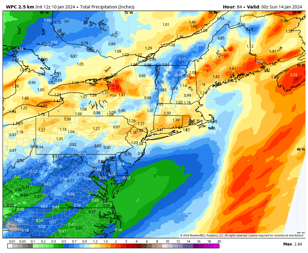
In the Mid-Atlantic and Northeast, forecasts are for around a half-inch to 2 inches. The upper end of this range could bring renewed river flooding after several gauges reached historic levels Wednesday.
How to prepare your home for extreme cold, and stay warm in a power outage
Like its predecessor, this storm will also contain strong wind gusts. Gusts of 50 mph are likely along the Interstate 95 corridor from North Carolina to Maine, with a few gusts of 60 mph along the immediate coastline of Long Island, parts of Connecticut, Rhode Island and southeastern Massachusetts. Down East Maine will also see some very strong gusts. More power outages seem inevitable.
Frigid weather in storm’s wake
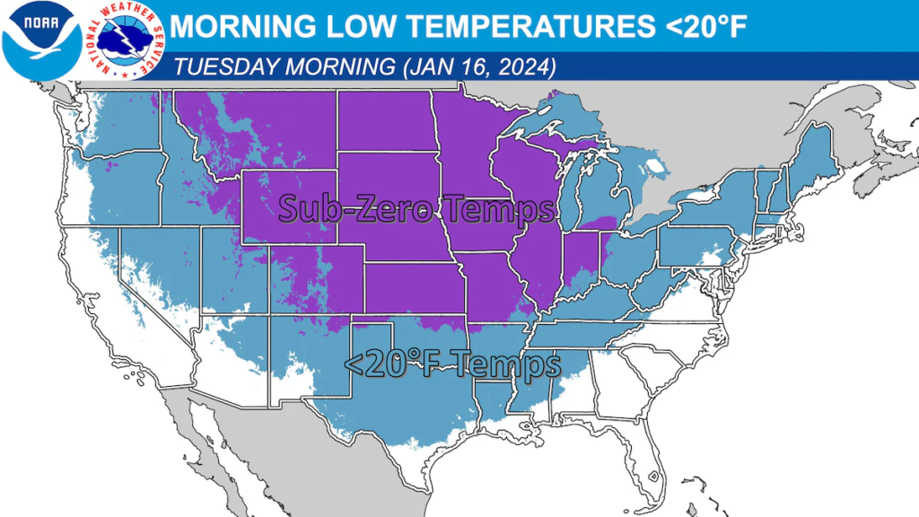
On the storm’s back side, the coldest air of the winter will plunge southward. The most bitter air is forecast to target the zone from Montana to the Texas Panhandle, where temperatures will be at least 30 to 40 degrees below normal over the weekend.
By Tuesday, the Weather Service projects subzero cold from Montana to Missouri.
Jason Samenow contributed to this report.
More on Winter Storm and Cold Wave Gerry:
Latest 72-Hour Probability of Snow Accumulating ≥ 8". #Jerry is expected be much more impactful to Chicago and Milwaukee. Prime time SNOW will be Friday into Saturday morning. pic.twitter.com/27lp19IcFB
— Jim Cantore (@JimCantore) January 10, 2024
The #Chiefs and #Dolphins game on Saturday night will be one of the coldest games in NFL history.
— Colin McCarthy (@US_Stormwatch) January 10, 2024
Wind chills during game time are forecast to be between -10°F and -15°F 🥶
Are the Miami Dolphins ready for the cold? pic.twitter.com/6UIHG5ZtZ5
The third winter storm in a week is already not playing games. Blizzard Warnings by NWS Seattle are up for the Olympics & Cascades…something they haven't done in over a decade!
— Alex Wallace (@TWCAlexWallace) January 10, 2024
Then, it brings more snow to the Midwest & Great Lakes!
Stay up to date with the @weatherchannel pic.twitter.com/RFEau1lS9p
Median or middle-range of expected snowfall over next 3-days from powerful winter storm across the Great Lakes
— Ryan Maue (@RyanMaue) January 10, 2024
Large area of 12"- 15" of snowfall including Milwaukee, Chicago, and Grand Rapids.
Get your plows/snow blowers ready! pic.twitter.com/g6fAB4MO2B
Here is the 2nd round of Key Messages for the Jan 14-17 period regarding a bitter cold outbreak with potential for snow impacting the Plains, Midwest, and Mid-South. pic.twitter.com/xd63q8GoZm
— NWS Weather Prediction Center (@NWSWPC) January 10, 2024
Here are more “ET’s” recorded from around the planet the last couple of days, their consequences, and some extreme temperature outlooks, as well as any extreme precipitation reports:
Insane July temperatures tonight in Central Asia with temperatures of 10C/15C at dawn not only in Turkmenistan but even in Kazakh highlands at 800m asl.
— Extreme Temperatures Around The World (@extremetemps) January 10, 2024
24 hours Tmin of +11.1C at Shymkent is the highest MIN in January in Kazakhstan
Records in Mongolia too
It's just the beginning https://t.co/PajbCeiv12
Another exceptional record in SE Asia.
— Extreme Temperatures Around The World (@extremetemps) January 10, 2024
Huyen Tran in the Spratly Islands,VIETNAM had a MINIMUM temperature of 28.0C,which ties the highest minimum temperature ever recorded in Vietnam in January.
The heat has been intense and relentless despite being the coolest days of the year pic.twitter.com/YWsBCj8WK4
South America Heat Wave
— Extreme Temperatures Around The World (@extremetemps) January 10, 2024
More records fell today in Brazil,Bolivia and Paraguay with temperatures up to 44C
PARAGUAY
42.8C Pozo Colorado tied its monthly record
BOLIVIA
42.4C San Jose de Chiquitos smashed its monthly record,after beating every single monthly record since mid 2023 pic.twitter.com/hcD9JHbEWJ
#BREAKING – #Sydney has today registered its highest dew point on record, based on hourly observations, after reaching 25.9ºC at 11am. Sub-hourly dew points have gone as high as 26.7ºC so far, although these can't be compared to historical data. Phenomenal obs for Sydney. https://t.co/jqVunTG8mL
— Ben Domensino (@Ben_Domensino) January 11, 2024
Here is more brand-new December and 2023 climatology:
2023 in #Brazil 🇧🇷 was the hottest year on record, driven by an insanely hot second half where every single month was the hottest on records with thousands records smashed allover no-stop (and going on in 2024).
— Extreme Temperatures Around The World (@extremetemps) January 10, 2024
A year like no other. https://t.co/mHNTNLQI5I
2023 in #Puerto Rico was the warmest year on record.
— Extreme Temperatures Around The World (@extremetemps) January 10, 2024
Average temperature was 82.2F/27.9C , +1.0F vs 1991-2020.
From July to November every month was the hottest on record,than December slowed down a bit but remained warm
See graph by NOAA. pic.twitter.com/ayJyBDrrp4
December 2023 in #Uruguay instead was cooler than average:
— Extreme Temperatures Around The World (@extremetemps) January 10, 2024
Temperature anomalies ranged from normal in the SE to 1.5C below normal in the Northwest.
El Niño pattern favours wet conditions in SE Brazil and Uruguay.
Map by Inumet. pic.twitter.com/zc8wBHfjzw
December 2023 in New Zealand had an average temperature of 16.9C, +1.1C above normal.
— Extreme Temperatures Around The World (@extremetemps) January 10, 2024
Raoul Island,Westport and Hawera broke their monthly heat records.
2023 as a whole had an average of 13.61C, 0.87C above normal and was the SECOND warmest year after 2022 and ahead of 2021. https://t.co/kWm786s9gn
December 2023 in #Ukraine was another exceptionally mild month with temperature anomalies between 1.7C and 3.9C above normal.
— Extreme Temperatures Around The World (@extremetemps) January 10, 2024
It was quite humid specially in the West.
See rainfall totals map courtesy of Ukraine Hydrological Service. pic.twitter.com/UnmlMcMXbY
December 2023 in #Moldova was another record warm month:
— Extreme Temperatures Around The World (@extremetemps) January 10, 2024
Temperature anomalies ranged between 3C and 3.5C above average (left map).
It was mostly dry,specially in the South with rainfall totals about the half of average. (right map).
Maps by SHMS. pic.twitter.com/0ky27v1VWg
December 2023 in New Caledonia was another hot and dry month, influenced by El Niño pattern.
— Extreme Temperatures Around The World (@extremetemps) January 10, 2024
Average temperature was 26.35C, +0.8C above normal with total rainfalls ranging from 2.8mm to 145.5mm (62% below normal). pic.twitter.com/5Ct8EYLBbk
Here is More Climate News from Wednesday:
(As usual, this will be a fluid post in which more information gets added during the day as it crosses my radar, crediting all who have put it on-line. Items will be archived on this site for posterity. In most instances click on the pictures of each tweet to see each article. The most noteworthy items will be listed first.)
2023 was the hottest year on record globally, and the 5th-hottest for the U.S., per NOAA. These chart-topping temperature rankings are part of a decades-long trend of rapid warming caused mainly by carbon pollution: https://t.co/cK8cFmb2zU 🌡️ #ClimateMatters pic.twitter.com/uWgGuqEtYP
— Climate Central (@ClimateCentral) January 10, 2024
Shocking. 2001-2022 an area 11X the size of the forests planted was lost to fire (average annual) Not only are we losing the battle for a safe future on Earth, we are cheating ourselves, allowing fossil-fuel offsetting against volatile green carbon sinks https://t.co/XL1HVBUtKJ
— Johan Rockström (@jrockstrom) December 23, 2023
‘We can’t pretend the ecological crisis is separate’: the economist thinking differently about climate breakdown https://t.co/dKmBbPIkku
— Guardian Environment (@guardianeco) January 10, 2024
For those keeping track, yesterday's global SST reached yet another new record, at 6.23σ above the 1982-2011 mean. pic.twitter.com/5rZVTij6t2
— Prof. Eliot Jacobson (@EliotJacobson) January 10, 2024
Latest C3S climate model compilation is out for January. It shows +ENSO rapidly fading in spring, although there's a wide spread in outcomes. ECMWF seems to be on the warmer side compared to others, but all pretty much go neutral or La Niña by the start of hurricane season. pic.twitter.com/x4vIVLtg7B
— Andy Hazelton (@AndyHazelton) January 10, 2024
Climate change rule of thumb: cold "things" warming faster than warm things.
— NOAA Climate.gov (@NOAAClimate) January 10, 2024
– Colder places are warming faster than warmer places.
– Colder seasons are warming faster than warmer seasons.
– Colder times of day are warming more than warmer times of day.https://t.co/S28VYdqpLY pic.twitter.com/N9K2EEdTJ4
Energy of '25 billion atomic bombs' trapped on Earth in just 50 years, all because of global warming
— GO GREEN (@ECOWARRIORSS) January 11, 2024
the oceans have absorbed around 89% of the energy (338.2 zettajoules)
However, the oceans will not protect our planet foreverhttps://t.co/HJtzIzNRKX
2023 marks the first time on record that every day within a year has exceeded 1°C above the 1850-1900 pre-industrial level for that time of year.
— Dr Sam Burgess 🌍🌡🛰 (@OceanTerra) January 11, 2024
Close to 50% of days were more than 1.5°C warmer than the 1850-1900 level, and two days in November were, more than 2°C warmer. pic.twitter.com/26SLacmo1t
Global warming acceleration. pic.twitter.com/FJ5N3YRsyQ
— Prof. Eliot Jacobson (@EliotJacobson) January 10, 2024
More from the Weather Department:
I wish this was a joke. But another similar setup we just had starts tomorrow. Already showing some big storms possible Friday from the SPC. This Friday! https://t.co/Hk3pbO7x8H pic.twitter.com/ZNq9atayKZ
— Mike's Weather Page (@tropicalupdate) January 10, 2024
An emergency warning was issued at Hampton Beach, New Hampshire, today following extremely high seas and significant flooding.
— AccuWeather (@accuweather) January 10, 2024
Homes have been evacuated as floodwaters overtook streets. Ocean Boulevard is closed, and residents are advised to avoid the area. #NHwx pic.twitter.com/QU7XaSvrqG
Historic storm surge event in Maine this morning. Bar Harbor (data since 1947) had its highest water level on record: 4.33’ above MHHW (previous record: 3.84’, 4/10/2020). Portland (data since 1912) had its 3rd highest: 3.93’ above MHHW (record: 4.22’, 2/7/1978). @Revkin https://t.co/fAP15bo7M9 pic.twitter.com/H2DWGLkjzz
— Jeff Masters (@DrJeffMasters) January 10, 2024
The #oceans will come. Later is too late to act. #Hampton Beach, New Hampshire, United States today. #Mitigation is urgent before the seas rise. pic.twitter.com/c4rZDpz0yu
— Peter Dynes (@PGDynes) January 10, 2024
BREAKING: Search and rescue efforts are in effect due to an avalanche at Palisades Tahoe in Lake Tahoe.
— The Weather Channel (@weatherchannel) January 10, 2024
Eyewitnesses say multiple people were buried in the slide. We'll continue to add updates as more information comes in. pic.twitter.com/S4jQplV25p
When was the last time @JimCantore experienced a snowstorm like this?
— The Weather Channel (@weatherchannel) January 9, 2024
Despite temperatures ABOVE freezing in Davenport, Iowa, the area has picked up over 8 inches of snow. #Finn pic.twitter.com/vNGsgKkm67
Snow blankets this barn in Colorado as a winter storm brought near-whiteout conditions to parts of the state this week. 🐴❄️ pic.twitter.com/eQJ6s6cVLQ
— AccuWeather (@accuweather) January 10, 2024
New Weather West post: Stronger/colder storm this weekend in NorCal (especially if you believe ECMWF model!), but then transition back toward much warmer/drier pattern. Also: what's up w/ElNino, & what parts of CA saw a record warm December? #CAwx #CAwater https://t.co/6bGCHYCBaZ
— Dr. Daniel Swain (@Weather_West) January 11, 2024
My next YouTube virtual office hour session: Thu Jan 11 @ 2pm PT. Weather update: what's happening this week, what's to come, & what the heck is going on w/El Nino & CA impacts? Plus: thoughts on 2023 as Earth's warmest year on record. #CAwx #CAwater https://t.co/wNCoVwyUdP
— Dr. Daniel Swain (@Weather_West) January 10, 2024
#PoalrVortex continues to do its best to keep us guessing with all kinds of mischievous tricks but I do my best to isolate the signal from the noise. It's also the world premier of some new diagnostics for winter weather lovers or haters! Blog now public: https://t.co/Gg8N2KHLUk pic.twitter.com/O49H61OYvL
— Judah Cohen (@judah47) January 10, 2024
First look at the summer 2024 outlook from the North American Multi-Model Ensemble (NMME). Thanks, I hate it! 🔥🔥🔥 pic.twitter.com/E5UZcpECwE
— Brian Brettschneider (@Climatologist49) January 10, 2024
Today’s News on Sustainable Energy, Traditional Polluting Energy from Fossil Fuel, and the Green Revolution:
A genuine piece of good news: a giant battery has replaced Hawaii's final coal power plant. https://t.co/7B4wDNbYYX
— David Roberts (@drvolts) January 10, 2024
Big Oil is trying to defend its absurd LNG buildout on the grounds that it is defending Ukraine.
— Bill McKibben (@billmckibben) January 10, 2024
There's already more than enough gas for Europe–as Ukrainian energy expert (and climate hero) @SvitlanaRomanko points out here. https://t.co/QQ5qAWoTZr
Good morning with good news: "Gasoline is cheap right now but charging an EV is still cheaper." How much cheaper? About 50%!
— John Raymond Hanger (@johnrhanger) January 10, 2024
National average cost of charging an EV is equivalent of $1.41 per eGallon.
EV: cheaper & cleaner to fuel!
Credit @karinkirk_mt https://t.co/h89PkVFA2u pic.twitter.com/c2Kq7i6i8t
"We analyzed 5 recent large-scale power failures in the US, including the rolling blackouts caused by Winter Storm Uri in 2021. We found that gas plants accounted for most of the failed capacity in all 5 events."
— David Roberts (@drvolts) January 9, 2024
The "reliability" of fossil gas is a myth.https://t.co/nmzXO0ze1F
Wow! IEA reports global investment in just solar was more than oil production in 2023!
— John Raymond Hanger (@johnrhanger) January 10, 2024
In 2013 investment in solar was about one-sixth of investment in oil production.
Investment in clean energy was $1.8 Trillion in 2023 or ~80% more than fossil fuels.https://t.co/h6KedgMQUv pic.twitter.com/Al6Hjv1gKc
Imports of energy products made up 17.7% of all EU imports in Q3 2023.
— Bojana Bogojevic 🌍 (@BojanaBogojevic) January 10, 2024
🇳🇴🇺🇲 #Norway and #UnitedStates – key energy suppliers! #energy #EnergyTransition#SDGs #climatechange#Sustainability@ProfStrachan@climateguyw@Sdg13Un#EnergyEfficiencyhttps://t.co/5iIzAZ94qc pic.twitter.com/zjJZ9Bnw0M
Your 'moment of doom' for Jan. 10, 2024 ~ Environmental destruction is our legacy.
— Prof. Eliot Jacobson (@EliotJacobson) January 10, 2024
"Norway intends to mine for minerals such as magnesium, cobalt, copper, nickel and rare-earth metals found in manganese crusts on seamounts and sulfide deposits…"https://t.co/bFg8zjO27i
I still can’t get over the fact that China’s rooftop solar installations alone are bigger than the entire solar fleet any other country on earth 🤯 pic.twitter.com/AqSyB3h9Ib
— Justin Guay (@Guay_JG) January 10, 2024
More on the Environment and Nature:
Study finds microplastics in nearly all US proteins: meat, fish and plants #plastichttps://t.co/3tsvxM6gYK
— Damian Carrington (@dpcarrington) January 10, 2024
Researchers find we can now wash down the microplastics in our tofu, or steak, with a much larger quantity of nanoplastics in bottled water than previously known.https://t.co/7weeaSBA5f
— Inside Climate News (@insideclimate) January 10, 2024
Night Thoughts
— Green is a mission (@Greenisamissio1) January 10, 2024
Respect Morgan Freeman
He said:
"There is a concerted effort for bringing bees back onto the planet…We do not realize that they are the foundation, I think, of the growth of the planet, the vegetation…"🐝🌿🌱☘️🌳🌲🍀💚 pic.twitter.com/7jcufkkmQF
Mass seal deaths in southern Atlantic confirmed as bird flu https://t.co/efesNtqg8K
— Guardian Environment (@guardianeco) January 11, 2024
More on Other Science and the Beauty of Earth and this Universe:
Early naturalists named species in Greek and Latin, largely ignoring Indigenous words for the world's plants and animals.
— Yale Environment 360 (@YaleE360) January 10, 2024
Some experts are now proposing a way to update scientific nomenclature to use Indigenous names.https://t.co/iElYoZPOkg
This is a male Mandarin Duck – it's colourful plummage is designed to attract a mate but it also does fairly elaborate dances – it's a true casanova of the bird world.
— Mike Hudema (@MikeHudema) January 10, 2024
Nature is amazing. Protect it.#ActOnClimate #climate #biodiversity #rewilding pic.twitter.com/7wPsC7yHCY
Unstoppable, the journey of life continues on a new morning and I wish my beloved and much appreciated fellow inhabitants of planet Earth a peaceful, wonderful good morning and a blessed day accompanied by respect and kindness. May God bless you.❤️💙💚🌿🌱☘️🌳🌲🍀💚 pic.twitter.com/P2xmDbjgX5
— Green is a mission (@Greenisamissio1) January 11, 2024
I wish my beloved and much appreciated fellow inhabitants of planet Earth a relaxed and peaceful good evening and a blessed night. Stay healthy and kind and enjoy the time. May God bless you.❤️💙💚🌿🌱☘️🌳🌲🍀💚 pic.twitter.com/a2McZ8GqoT
— Green is a mission (@Greenisamissio1) January 10, 2024