The main purpose of this ongoing blog will be to track planetary extreme, or record temperatures related to climate change. Any reports I see of ETs will be listed below the main topic of the day. I’ll refer to extreme or record temperatures as ETs (not extraterrestrials).😜
Main Topic: Weird Warm and Dry Weather Rules in October Across the U.S.
Dear Diary. It has been unusually dry and warm across the United States this October, and it appears that there will not be a strong enough cold front followed by a cold enough air mass to prevent this:
In my hometown of Atlanta no rain has been reported since September 29th, which is highly unusual even though October is typically the driest month of the year here. There has never been a totally dry month at Atlanta in climatological records.
Looking at record counts as a measure for climate change induced warmth, so far this October there have been 3914 reports of daily record high maxes, only 425 daily low minimums, 2688 daily high minimums, and only 425 daily low maxes. From:
Such a disparity between daily record warmth and chill counts is a good indication that October will be at least a top ten warm month since 1895 when rankings started, and there will be another couple of thousand reports of warm records at least if meteorological models are correct through the end of the month.
Global warming more often than not produces dry high pressure. Another big heat dome and associated high pressure area will develop across the eastern U.S. for the end of October:
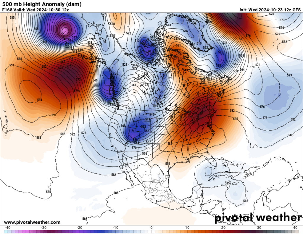
A 588+ decameter ridge is unheard of going into November. What’s that lurking in the Caribbean? More tropical trouble might affect the U S. going into early November. This should be expected since we have record warm Caribbean waters. Think of this month as a big extension of September when we did see devastating hurricanes. The lack of cold air masses moving into the South will also not work in our favor, although it is way too early for any deterministic models to make a good forecast. Any developing tropical cyclone may miss the U.S. entirely.
Should we welcome this extension to summer? While many people are delighted to wear shorts so late in the year, farmers are starting to suffer because of drought. Apple growers across the Northeast are warning of poor harvests, for example. The dry warm weather is also leading to brushfires:
Here is a report from the Washington Post with a focus on the Washington D.C. area:
D.C. hits a 21-day streak without rain as drought concerns return – The Washington Post
D.C. just hit 21 days without rain as drought concerns return
The dry streak could become one of the 10 longest ever observed.
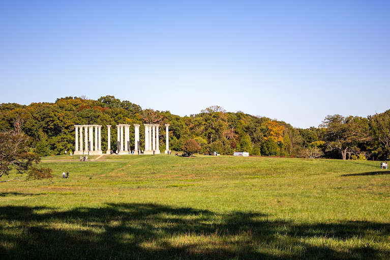
Shades of brown in the grass at the National Arboretum on Saturday. (Becca Hanby)
By Ian Livingston and Jason Samenow
Updated October 23, 2024 at 9:27 a.m. EDT|Published October 22, 2024 at 12:22 p.m. EDT
With a forecast for clear skies and dry weather through at least the next week, Washington is poised to clinch one of its longest streaks without measurable rain on record. The rainless streak hit 21 days Wednesday and will probably become one of the 10 longest ever observed.
Drought is advancing back into the area from the west and north, according to the U.S. Drought Monitor, and it will continue expanding until meaningful rain arrives.
Much of the D.C. area is already designated as “abnormally dry,” while moderate to severe drought can be found in northeast Maryland, Delaware, southeast Pennsylvania and southern New Jersey. In West Virginia, the drought intensifies from moderate along the Virginia border to extreme and exceptional in the central and western parts of the state.

The District finds itself on the verge of drought just a few weeks after it rained for 11 straight days to end September and start October; the streak tied for the second-longest on record.
Drought has flirted with the area on and off since spring.
How dry it’s been
Much of the Washington region has seen little to no rain since it was doused with 1.48 inches during October’s first two days.
Washington’s run of 21 days without measurable precipitation has entered the 25 longest such streaks on record.
Assuming no rain falls before Sunday, it will rank among the 10 longest. If no rain falls in the next week, as predicted, it will enter the top five.
The District’s longest streak without rain — 34 days — occurred between September and October in 2007. Almost all of the lengthiest dry streaks have come during fall, a preferred time for extended periods of nice, sunny weather in the D.C. region.
Both Washington Dulles International Airport and Baltimore are also experiencing dry streaks of 20 days and counting.
Why has it been so dry?
For much of October, a large zone of high pressure and sinking air has sprawled over the eastern half of the United States. Centered over the Midwest, it has blocked precipitation systems to the west from progressing eastward.
Because of the lack of rain over such a large area of the country, the Lower 48 states are on pace to post its second-driest month on record. Precipitation averaged over the Lower 48 is just 0.57 inches so far, according to Brian Brettschneider, a climatologist based in Alaska. About half of the locations in the Lower 48 with weather data have posted their driest October on record to date.
The dry pattern may be connected to a slowly developing La Niña event, which is associated with episodic cooling of surface waters in the tropical Pacific Ocean. La Niñas tend to reduce autumn rainfall in the eastern United States. Washington’s second driest October on record, when just 0.02 inches of rain fell, was during a weak La Niña event in 2000.
The National Weather Service has yet to officially declare La Nina’s arrival this fall but it is predicted to develop by winter.
Matt Rogers, president of the Commodity Weather Group and a Capital Weather Gang contributor, said the atmosphere-ocean pattern known as the Pacific Decadal Oscillation may be playing a more important role in the lack of rain than La Niña.
The oscillation is “super-duper negative and breaking records,” he said. “It gives you a La Niña flavor without even having a La Niña.”
When this oscillation is strongly negative, water temperatures are abnormally warm in the northern Pacific Ocean. That tends to favor a dip in the jet stream over the western United States, bringing stormy weather as far east as the Rockies but tranquil and dry weather in the East.
Is there any rain in the forecast?

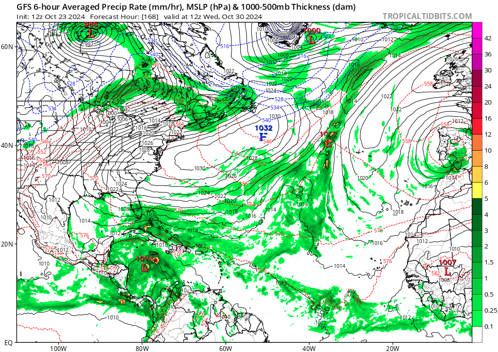
Predicted rainfall over through Nov. 1 by the American (GFS) model. Little or no rain is forecast for the D.C. area. (WeatherBell)
High pressure is forecast to remain anchored over the eastern United States for most of the rest of this month. That means little or no rain in the D.C. area. Occasional weak cold fronts will pass by and could produce the occasional brief shower, but these fronts will mostly be moisture-starved.
There is some possibility that during the first week of November, the high-pressure pattern will begin to break down and allow more storminess to affect the eastern United States from the west and/or the south.
During November, the Weather Service assigns equal chances to above- and below-normal precipitation.

By Ian Livingston Ian Livingston is a forecaster/photographer and information lead for the Capital Weather Gang. By day, Ian is a defense and national security researcher at a D.C. think tank. follow on X @islivingston

By Jason Samenow Jason Samenow is The Washington Post’s weather editor and Capital Weather Gang’s chief meteorologist. He earned a master’s degree in atmospheric science and spent 10 years as a climate change science analyst for the U.S. government. He holds the Digital Seal of Approval from the National Weather Association. Follow on X @capitalweather
Here are more “ETs” recorded from around the planet the last couple of days, their consequences, and some extreme temperature outlooks, as well as any extreme precipitation reports:
Here is More Climate News from Wednesday:
(As usual, this will be a fluid post in which more information gets added during the day as it crosses my radar, crediting all who have put it on-line. Items will be archived on this site for posterity. In most instances click on the pictures of each tweet to see each article. The most noteworthy items will be listed first.)