The main purpose of this ongoing blog will be to track planetary extreme, or record temperatures related to climate change. Any reports I see of ETs will be listed below the main topic of the day. I’ll refer to extreme or record temperatures as ETs (not extraterrestrials).😉
Main Topic: Unrelenting Heat Grips Northern Australia
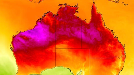
Dear Diary. It is now late spring across Australia, so dangerous climate change driven heat is already rearing its ugly hot head across portions of the continent. Dangerous heat is developing mainly across northern areas while spring fronts continue to cool the south. Contrasts in air masses has led to very stormy conditions across southern and eastern areas of Australia.
Here are some of the latest records from the country:
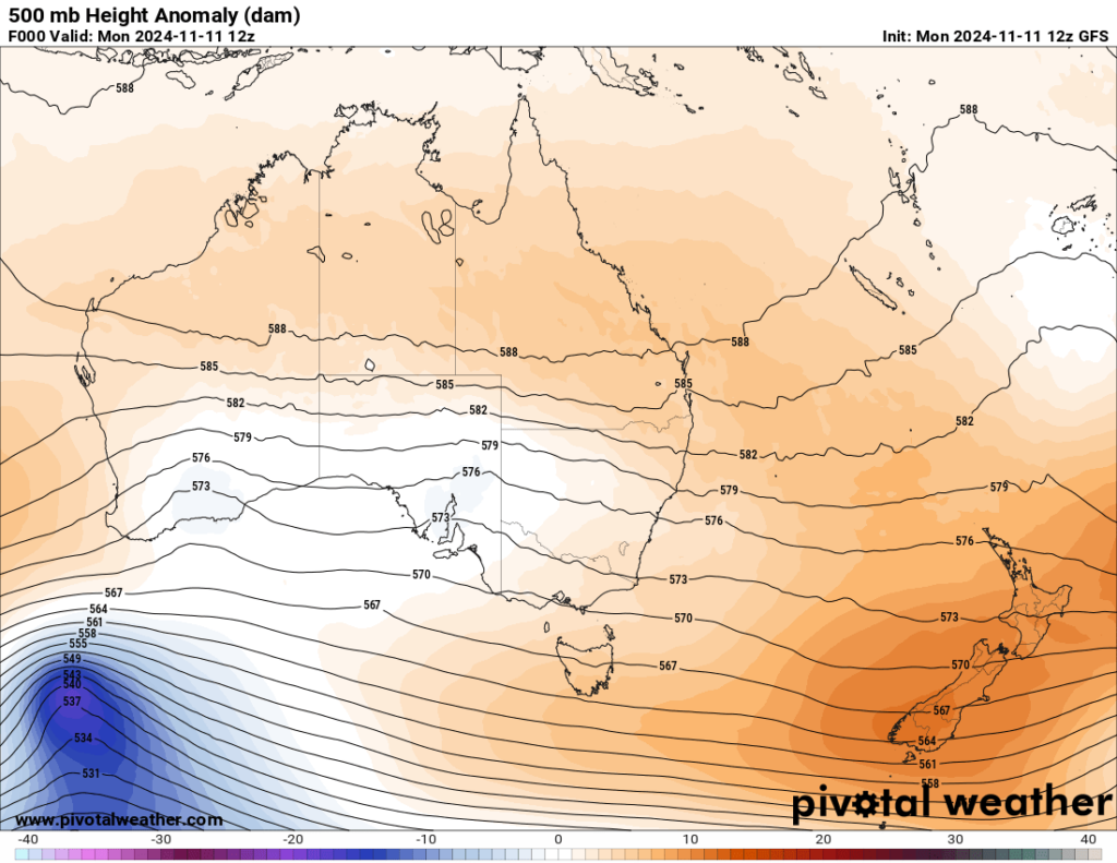
Looking at the state of the heat dome across Australia, it’s quite anomalously hot across all but far southern portions of the continent:

By late this week there won’t be too much change:

A cold front will start to cool western Australia while the heat dome noses southward into eastern Australia.
Here are a couple of articles indicating heatwave details for the continent:
Unrelenting heatwave gripping northern Australia
Unrelenting heatwave gripping northern Australia
Ben Domensino
07 Nov 2024

A severe to extreme heatwave will continue to bake northern Australia this weekend and into next week, with temperatures possibly approaching the high-40s around Wednesday or Thursday.
The upper-level weather pattern over Australia is currently in a zonal state, meaning the upper-level winds are generally flowing in a west-east direction. This zonal flow is allowing a slow-moving upper-level high pressure system to remain centred over Australia, which is causing a very hot air mass to linger across northern parts of the country.
Over the past week, this hot air mass caused temperatures to exceeded 45°C at six separate weather stations in WA, Qld and northwest NSW, getting as high as 45.9°C at Roebourne in WA’s Pilbara region.
Unfortunately, the heat isn’t going anywhere soon and a severe to extreme heatwave – the two highest categories on the Australian heatwave scale – are set to linger in parts of WA, the NT and Qld through this weekend and into next week.
The maps below show the heatwave severity forecasts for the next six days, broken down into two three-day periods.

Image: Heatwave severity forecast for the three days starting on Friday, November 8, 2024.

Image: Heatwave severity forecast for the three days starting on Monday, November 11, 2024.
Some computer models suggest that maximum temperatures in far western Qld could hover around 41 to 44°C during the next seven days. There are also indications that temperatures could once again exceed 45°C in northern WA around Wednesday or Thursday next week.

Image: Forecast maximum temperature on Wednesday, November 13, 2024, according to the ECMWF-HRES model.
While northern Australia is usually hot at this time of year, the heatwave currently gripping the region is abnormally hot for November. In the Pilbara, Onslow Airport’s running average maximum temperature for the first week of November was 39.4°C, which is 5°C above the long-term average.
Millions brace for severe thunderstorms
Millions brace for severe thunderstorms
Story by Cameron Micallef and Aisling Brennan
11/9/2024
The Bureau of Meteorology forecasts severe thunderstorms for parts of north-west South Australia and across Western Australia’s interior, and through towards south-west parts of the Northern Territory.
The warning comes as hail and damaging wind gusts are also forecast as possible for those ares.

Millions brace for severe thunderstorms
Meanwhile, the Queensland Fire Department (QFD) has extended a local fire ban for Northern Region residents.
The local fire ban will now be in place until 11.59pm on Sunday for residents in the Charters Towers, Flinders and Richmond Local Government Areas only.
The local fire ban for the Croydon and Etheridge Local Government Areas will remain in place until 11.59pm on Saturday.
“Under a local fire ban all open fires are prohibited and all Permits to Light Fire which have been issued in the designated areas have been suspended for the duration of the ban,” QFD stated.
“Power tools may be used during a local fire ban however QFD encourages people to use these with extreme care and ensure adequate equipment is available to extinguish any fire which may start.
“This may include having a person available to watch out for any ignitions that occur.”
It comes as a hot air mass over the country’s north caused temperatures to exceed 45C at six separate locations in Western Australia, Queensland and NSW – getting as high as 45.9C at Roebourne in WA’s Pilbara region.
The “abnormally hot” temperatures are set to remain elevated amid a three-day heatwave warning for parts of Queensland.
The severe heatwave warning, issued by the Bureau of Meteorology (BOM), covers the Peninsula, Gulf Country, Northern Goldfields and Upper Flinders, Central Highlands and Coalfields, Central West, North West, Maranoa and Warrego, Darling Downs and Granite Belt, Wide Bay and Burnett and Southeast Coast forecast districts.
Maximum temperatures are forecast to hit the high 30s to low 40s, the BOM’s warning states.
Overnight, the mercury will only dip to the mid-to-high 20s, “tending mid-teens to low 20s in the southeast districts”.

Aussies brace for unrelenting heatwave, storms

Millions brace for severe thunderstorms
Brisbane is forecast to hit maximum temperatures of 30C over Saturday and Sunday.
According to Weatherzone, the heatwave gripping the three states is “abnormally hot” for the month of November.
“In the Pilbara, Onslow Airport’s running average maximum temperature for the first week of November was 39.4C, which is 5C above the long-term average,” a Weatherzone spokesman said.
The soaring heat in the eastern states could be tempered by a trough and low pressure system developing over the weekend, which is forecast to dump falls between 10-30mm over northeast NSW and southeast Queensland.
The cloud cover will develop over late Saturday morning and spread in the afternoon.
Thunderstorms are forecast to bring damaging winds, lightning strikes, and hail, which may also cause flash flooding over the Wide Bay and Burnett, southern Central Highlands and Coalfields and eastern Maranoa and Warrego districts.
In NSW, the warning has been extended to the Northern Rivers and Northern Tablelands regions.
On Friday, a combination of gusty winds and 30C temperatures resulted in a total fire ban for the greater Sydney region.
A grassfire which broke out at Sydney Airport as a result of an engine failure was exacerbated by the unfavorable conditions.
Melbourne is tipped to reach just 21C over the weekend while Adelaide is expected to remain cloudy with temperatures as high as 26C
Canberra is forecast for a maximum of 27C over the weekend, Perth 26C after storms on Friday, Hobart 19C and sunny, and Darwin a steady 35C.

Aussies brace for unrelenting heatwave, storms
The months from April to October were Australia’s third warmest on record – behind 2013 and 2005 in the Bureau of Meteorology’s 115-year data set.
Sky News meteorologist Rob Sharpe predicts November and December could experience extra rain and warmer-than-usual weather.
“There were few significant climate influences for the seven-month stretch, with El Nino officially ending as the season began,” he said.
Australia is seeing less rainfall than it is used to in the cool season – with this reduction most pronounced in the southern half of the country.
“northern Australia’s ‘dry season’ rainfall has remained quite steady with a marginal rise in this statistic,” Mr Sharpe said.
“Therefore, when looking at the map from the most recent seven months it shouldn’t come as a surprise to see the red shading mainly in the south and the blues in the north.”

Aussies brace for unrelenting heatwave, storms
Here are more “ETs” recorded from around the planet the last couple of days, their consequences, and some extreme temperature outlooks, as well as any extreme precipitation reports:
Here is more brand-new October 2024 climatology (More can be found on each past archived daily November post.):
Here is More Climate News from Monday:
(As usual, this will be a fluid post in which more information gets added during the day as it crosses my radar, crediting all who have put it on-line. Items will be archived on this site for posterity. In most instances click on the pictures of each tweet to see each article. The most noteworthy items will be listed first.)