The main purpose of this ongoing blog will be to track global extreme or record temperatures related to climate change. Any reports I see of ETs will be listed below the main topic of the day. I’ll refer to extreme or record temperatures as ETs (not extraterrestrials).😉
Main Topic: High Amplitude Polar Vortex U S. January 2024 and 2025 Cold Cases Pointing to Work of Dr. Jennifer Francis
Dear Diary. Now that the cold snap that I dubbed Chione for the Greek goddess of snow is over across the United States, it’s time to see if the event could be linked to climate change or is just a natural frigid variation of weather that can still occur because our climate is not totally broken yet. I would argue that Chione was a little bit of both effects.
We can look back to last year at this time to see another even more historic cold wave dubbed Gerry that affected the CONUS. Here are some excerpts from my diary back in January 2024:
Dear Diary. Given the law of averages and the fact that our basic climate isn’t broken beyond repair yet, the United States is having a big bought of winter weather this month after having a record warm December. However, this January’s winter weather is anything but typical. One winter storm this week dubbed by the Weather Channel as Finn has produced tornadoes over the Southeast, flooding rain from the Southeast into the Northeast and high winds toppling trees over the Northeast causing thousands to have power outages. It can be argued that extra heat put into the atmosphere from climate change caused Finn to become as strong as it was.
Now Gerry will be about as strong as Finn, if not stronger late this week and move across the same general area. Behind Gerry will come a severe Arctic outbreak not seen in years for some areas of the United States due to its intensity.
Dr. Jennifer Francis has posited that such an arctic outbreak is made more likely due to the weakening of the polar vortex because of warm air intrusions into polar areas at the jet stream level of the atmosphere. That science isn’t proven yet but given what I have witnessed as a meteorologist for decades, I would agree. Regardless, these arctic outbreaks are becoming rarer as our global warming trend continues.
Here is the link for my rules for naming cold waves:
Looking at the severity of Gerry, it is likely that the system will be a historic CAT4 and has the potential to be a real killer because some all-time record lows will be threatened in a few western and northern U.S. locations. It has been a while since I’ve seen thickness values below 498 decameters on surface charts, but that is indeed what is forecast late this week across the Upper Midwest:
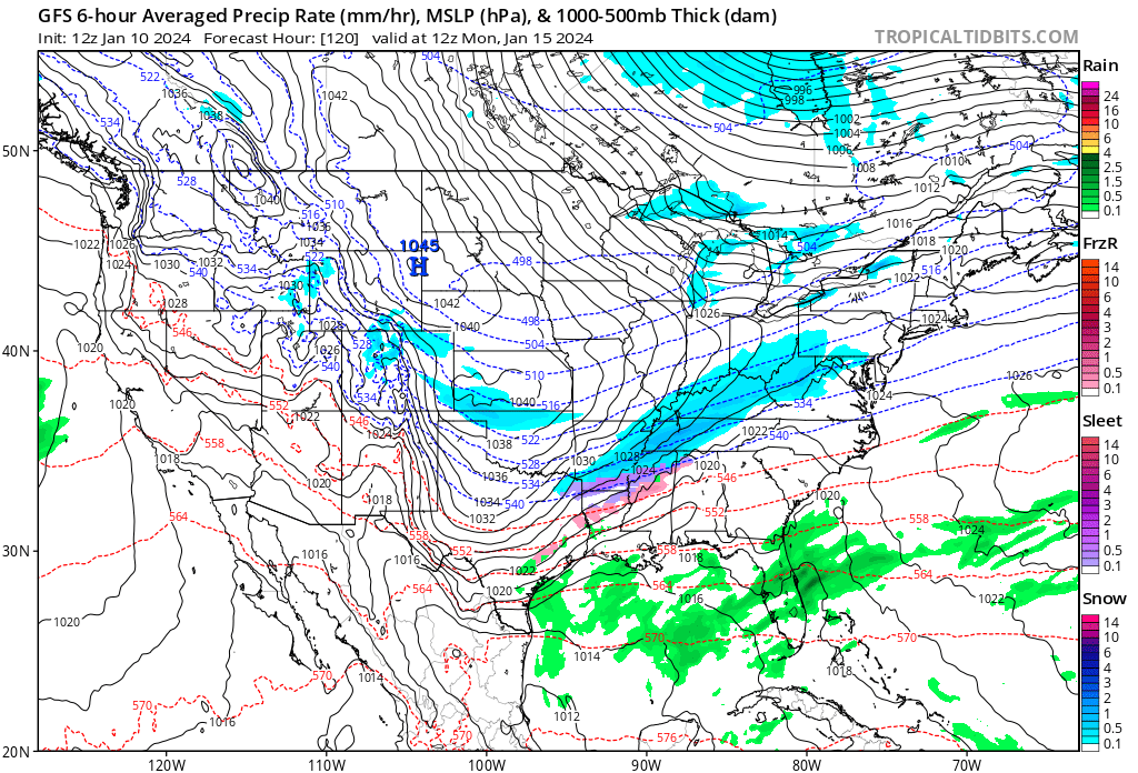
A near 1050 millibar Arctic surface high pressure cell will be driving record cold air south and east starting this weekend.
Aloft here is the forecast cold vortex in association with Cold Wave Jerry:
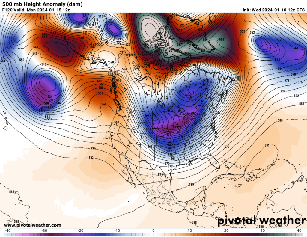
On the above Pivotal Weather chart one can see a Hudson Bay low slinging another chunk or lobe of the polar vortex southward, which is a typical setup for an Arctic outbreak that I have seen for many a moon. What is not typical is extreme polar warmth as noted by red and white anomaly colors on the chart. This warmth is forcing residual cold pockets southward over mid latitude areas.
Cold Wave Gerry will have a lot of fresh snow cover to move over from its storm component. Don’t forget that snow aids radiation of heat into space via its high albedo:
Today one can see below zero temperatures in association with Jerry building across western Canada. Outside of the most northern tier of states, the United States is having a relatively mild day ahead of an Arctic front marking the dividing line between cold and downright frigid conditions:
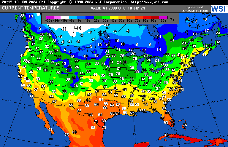
And here we find how cold it will be by Monday the 15th across the CONUS on the latest model run:
………………………………………………………………………………………………………………………………..
So how does 2024 Gerry compare with 2025 Chione? I’ve come up with the following chart to help do this:

During JAN 2024 there were an astounding 268 all-time cold records logged into NCEI’s record tracking system. In JAN 2025 only 26 have been recorded so far. As of January 25th, intense cold across the CONUS had ended, so I doubt we see any more reports of all-time record cold for JAN 2025. During both months snow cover was involved with setting new all-time records, aiding to deflect heat back into space. Many all-time records were set this January across the Gulf Coastal area because of astounding Gulf Coast snow cover.
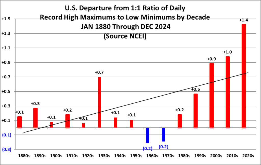
During these warming times we should not be seeing this many all-time cold records. Counterintuitively, we are seeing this effect on my all-time records chart. I contend that this effect stems from winter polar vortex amplifications becoming more common since the year 2010:
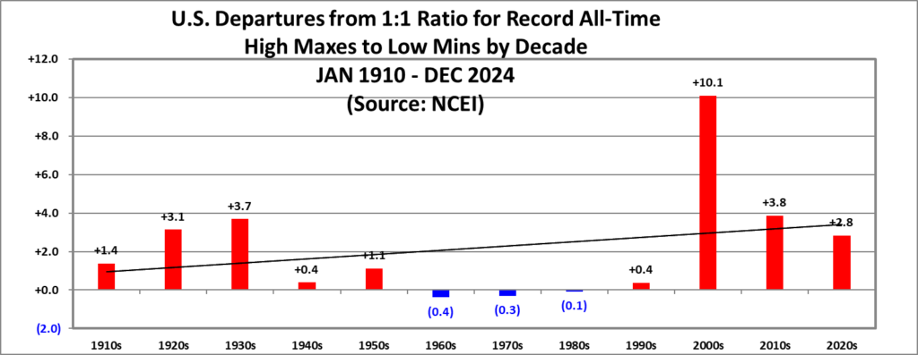
We would expect that all-time ratios from the 2010s and 2020s to be higher than the 2000s, but the opposite is happening. Yet daily ratios are up:
I’ve noticed that the intense Arctic outbreak occurred this January while astounding warmth was occurring across the rest of the planet and in particular Alaska (an effect singly repeated time and again when North America sees large Arctic outbreaks during winter. Perhaps teleconnections need to be looked at in a new scientific study?):
Across the Western Hemisphere we see yet another high amplification polar vortex case with lots of anomalous warmth pushing northward into the Arctic forcing cold air into the CONUS earlier this month in association with Chion. Alaskan warmth is quite stark:
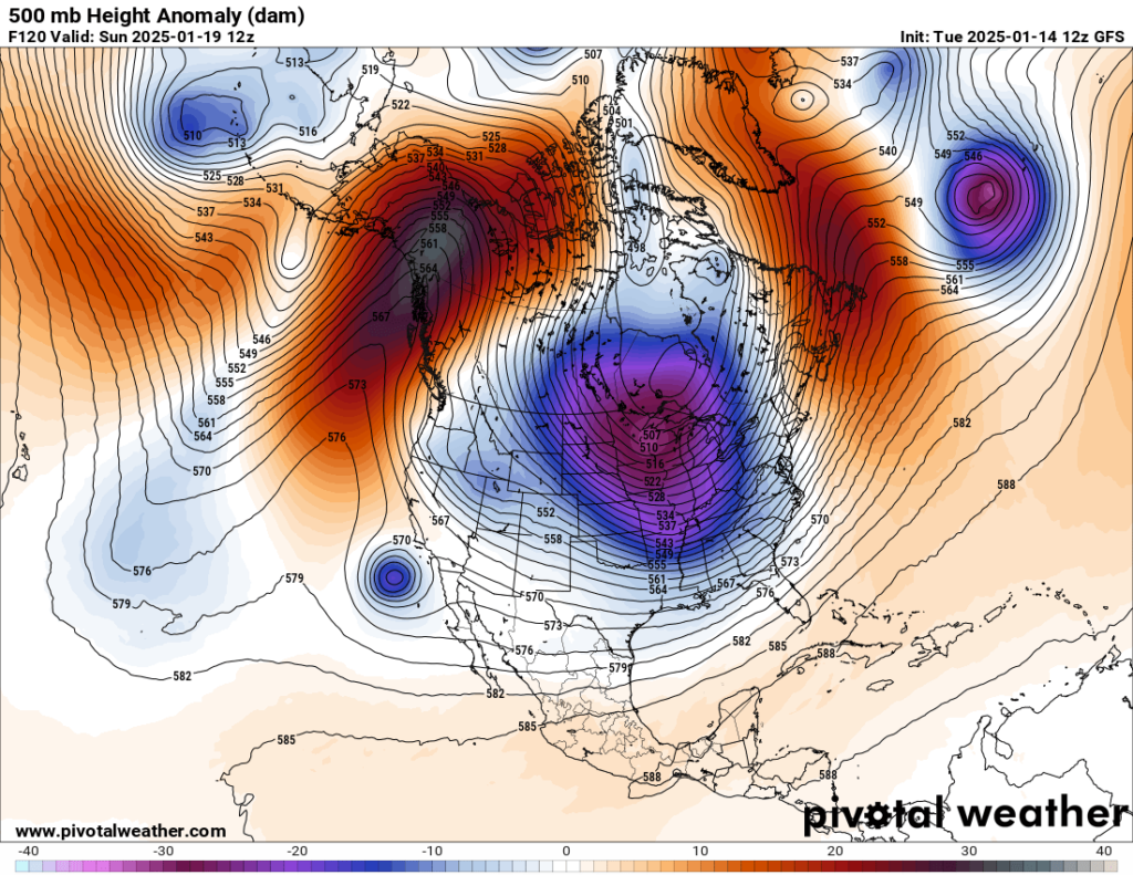
So, I think that during both JAN 2024 and JAN 2025 we had two fairly obvious Dr. Jennifer Francis cases of climate change warmth interacting with the polar vortex making it quite wobbly. Will the rest of 2025 be as warm as that of 2024, which was the warmest on record for the CONUS after a very cold start? We, will see:

DHMX= Daily High Max Reports. DLMN= Daily Low Min Reports. DHMN= Daily High Min Reports. DLMX=Daily Low Max Reports.
Boldly highlighted red, blue, or purple colored months, such as December 2023 and June 2021, that have ratios of >10 to 1 daily or <1 to 10 of daily warm to low records are either historically hot or cold, most of which have made news. NCEI rankings are for the lower 48 states with the warmest ranking since 1895 of average temperatures being 130 and 1 being the coldest as of 2024. Blue colors represent cold months and red warm. Those months and years with counts close to a 1 to 1 ratio of highs to lows are colored black. All-time record hottest or coldest months and years are boldly colored in purple. NCDC rankings have been color coded (under tabs in each file) such that values of 54 to 74 are black representing neutral months or years (+ or – 10 from the average ranking of 64).
Here are more “ETs” recorded from around the planet the last couple of days, their consequences, and some extreme temperature outlooks, as well as any extreme precipitation reports:
Here is More Climate News from Sunday:
(As usual, this will be a fluid post in which more information gets added during the day as it crosses my radar, crediting all who have put it on-line. Items will be archived on this site for posterity. In most instances click on the pictures of each tweet to see each article. The most noteworthy items will be listed first.)