The main purpose of this ongoing blog will be to track global extreme, or record temperatures related to climate change. Any reports I see of ETs will be listed below the main topic of the day. I’ll refer to extreme or record temperatures as ETs (not extraterrestrials). 😉
Main Topic: Whiplash…Gulf Coast Experiences January Record Snow and Chill to Record Warmth in February
Dear Diary. Now that the planet is at about 1.4°C above preindustrial conditions and since another world heat record was set in January 2025, it is somewhat surprising that we had a record snowstorm accompanied by some all-time record chill across the Gulf Coast last month. What is not so shocking was how fast temperatures moderated such that record warmth has prevailed over the region the last week. Here is a snapshot of midafternoon temperatures across the U.S. from today 2/08/2024:
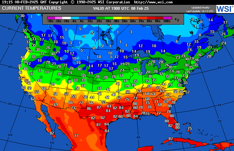
Readings as high as the mid-80s Fahrenheit are near daily records.
One explanation for this weather whiplash comes from Dr. Jennifer Francis. We explored what her work entails in association with the polar vortex and January’s record cold pattern here:
There are other technical reasons why such a historic snowstorm occurred across the Gulf Coast. For those details, here is a new article from Dr. Jeff Masters and Bob Henson writing foe Yale Climate Communications:
What caused the Gulf Coast’s incredible January snowstorm?
It broke century-plus records for cold and snow in some spots – even as much of the nation had a less-than-brutal month.

by Bob Henson
February 7, 2025

Ace Staton puts Mardi Gras beads on her snowman on Orleans Avenue in the Mid-City neighborhood of New Orleans during a rare snowstorm on January 21, 2025. The winter storm shut down schools and businesses and drew out locals, many of whom had never seen snow before. (Image credit: Michael DeMocker/Getty Images)
As Super Bowl host city New Orleans basks in a stretch of record and near-record high temperatures around 80 degrees Fahrenheit ahead of the big game on February 9, it’s hard to fathom that the city was snow-covered and well below freezing less than three weeks earlier.
This episode of merciless-to-mild weather whipsawing played out across much of the central and eastern United States during the first days of February. Perhaps nowhere was it as vivid as along the upper U.S. Gulf Coast, not long after the region was gripped by some of its heaviest snow and deepest cold on record. The fast-hitting snowfall swept through on Tuesday, January 21, and rapid clearing paved the way for temperatures to plummet to astoundingly cold lows atop the snowpack the next morning (more details below on the snow and cold records set).
With fierce winds and temperatures in the 20s Fahrenheit during the height of the snow, the January 2025 storm – which prompted what appears to have been the Gulf Coast’s first-ever blizzard warning – led to at least 13 fatalities and caused at least $500 million in damage. The official numbers from NOAA’s National Centers for Environmental Information were still pending as of this writing.
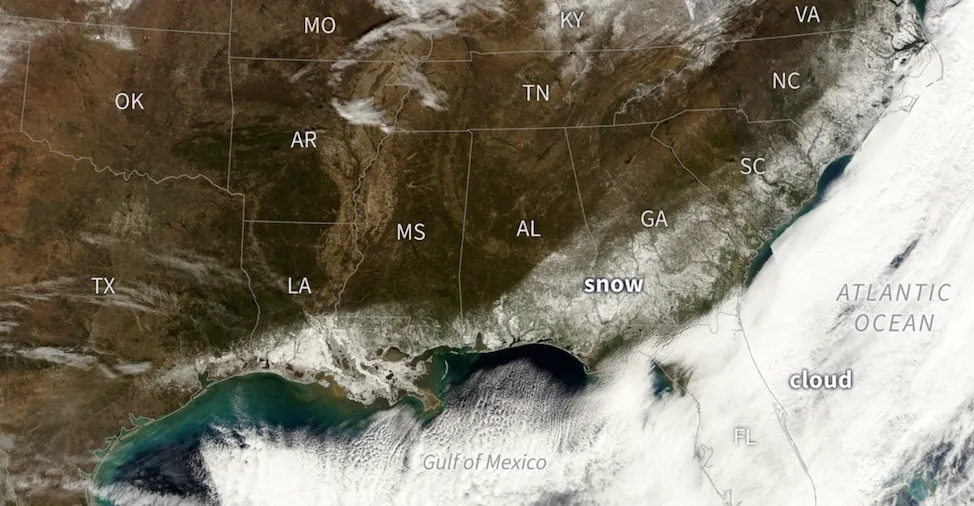
Figure 1. On the morning of January 22, 2025, after cloud cover from the previous day’s historic snowstorm had departed, satellites captured an unusual sight: a swath of snow on the ground arcing around the Gulf Coast and the Atlantic Southeast. Radiative cooling atop the snowpack led to many record-setting low temperatures for the date, as well as several all-time record lows for any date. (Image credit: Climate.gov, based on data from the NOAA-21 satellite’s VIIRS sensor.)
Stretching the polar vortex
It may come as a surprise, but the infamous “polar vortex” didn’t actually set up shop in the United States during the persistent January cold and the Gulf Coast’s winter storm. The main polar vortex is in the stratosphere, roughly 10 to 30 miles high, where it takes shape each winter and typically encircles the North Pole. Sometimes the stratospheric polar vortex splits or gets dislodged in ways that push its center unusually far south. It can also stretch well southward. But the vortex needs a lower-altitude teammate to produce high-impact U.S. winter weather.
That partner is the troposphere (or Earth’s “weather layer”), which extends up to a few miles above ground level. In the troposphere, dips (or troughs) and bulges (or ridges) in the jet stream can extend far north and far south across the midlatitudes of North America and Eurasia. These features are sometimes juxtaposed in a way that generates extreme winter weather without necessarily syncing with the polar vortex higher up.
In a January 30 post at Climate.gov’s Polar Vortex Blog, NOAA meteorologist Laura Ciasto and research scientist Amy Butler noted:
So far, this year has been a good example of how the polar vortex doesn’t always impact weather at the surface and why we need to remember these typical impacts are not guaranteed. The polar vortex winds have been much stronger than normal, but other than some brief interactions in late December and late January, the stratosphere and troposphere have largely ignored each other.
The stratospheric polar vortex did stretch unusually far south during mid-to-late January (see Fig. 2 below). Such a vortex stretch has been implicated in several recent U.S. cold-season extremes, including the catastrophic winter storm centered on Texas in February 2021 that took at least 290 lives and inflicted more than $25 billion in damage.
We’ll circle back to the stratospheric polar vortex – and take a fresh look at the influence of climate change on U.S. winter weather – in part two of this two-part post.
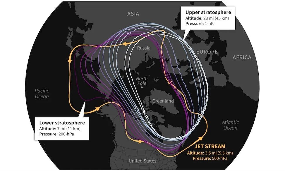
Figure 2. Structure of the tropospheric jet stream (yellow) and several levels of the stratospheric polar vortex from the lower stratosphere to the upper stratosphere in the NOAA GFS model forecast for Jan. 17, 2025, as initialized on January 16. The contours show how the stretched polar vortex corresponded to the southward shift of the jet stream over North America. (Image credit: NOAA Climate.gov, adapted from original by Laura Ciasto)
The elongated polar vortex in mid-January 2025 pushed very cold and extremely dry surface air southward across the central and eastern U.S., reinforcing what had been several weeks of persistent but not exceptional cold.
Once in place along the Gulf Coast, the cold surface air was overtopped by a strong impulse in the jet stream that created a zone of intense rising motion across the upper Gulf Coast on January 21. Meanwhile, a surface low intensified well south of the coast, across a near-record-warm Gulf of Mexico. The low-level circulation wasn’t especially strong, but it did help to bring just enough moisture into the snow formation zone along the Gulf Coast to yield nearly ideal snow-making conditions there.
Winter weather isn’t going away anytime soon
Events like January’s multiple disasters make it clear that the worst episodes of winter weather still have to be taken seriously, even as research agrees that winter’s bite is growing less sharp in many areas. A major assessment of the disastrous 2021 winter storm in Texas, led by Rebecca Bolinger at Colorado State University, warned:
Even in the context of a warming climate, cold events such as this should be considered when assessing risk and hazard mitigation planning. The magnitude of impacts associated with this event suggests a lack of preparedness that needs to be addressed.
In a 2024 paper, Russell Blackport and John Fyfe, both at the Canadian Centre for Climate Modelling and Analysis, emphasized why North Americans in particular shouldn’t get too sanguine about winter:
Winter temperatures over North America in the current climate have the highest variance and are some of the most strongly negatively skewed on Earth. This means that extreme deviations below the mean are expected to continue to occur in the future, even with rising global temperatures. However, because of the increasing mean temperatures, combined with the changes in temperature variability, cold extremes over North America will occur less frequently, and when they do occur, they will be less intense.
The World Weather Attribution project, which analyzes how much climate change might or might not have influenced recent weather extremes and disasters, tends to focus on extreme floods, heat waves, and other disasters that have clear-cut links to a warming planet. Among its few studies of cold events, one analyzed a sharp cold wave over far northern Europe in January 2024. The group estimated that human-induced climate change likely made such an event five times less frequent. But they stressed that complacency might have its own risks:
Climate change does not mean that cold waves will no longer happen. In fact, less severe and less frequent cold waves may be more impactful than past ones if risk perception and preparedness decrease due to the less frequent event occurrences.
It might not make much sense for cities right along the Gulf Coast to invest in fleets of snowplows, given the rarity of extreme winter weather like they saw in January. But as U.S. cities get ever larger, and living and working patterns grow ever more complex, it will behoove residents nationwide not to dismiss winter hazards just yet – even as they also grapple with the reality of long-term human-induced warming.
Cold records set
Among the most noteworthy records set in January 2025:
Coldest temperature for any date, all on Wednesday, January 22:
- New Iberia, Louisiana*: 2°F (old record 17°F on January 17, 2018; data since 1948)
- Lafayette, Louisiana: 4°F (old record 9°F on December 23, 1989; data since 1893)
- Baton Rouge Metropolitan Airport, Louisiana: 7°F (old record 8°F on December 23, 1989; data since 1930)
- Jennings, Louisiana: 7°F (old record 9°F on February 12, 1899; data since 1897)
*On Thursday, February 6, New Iberia soared to 82°F, tying its warmest temperature on record for any date in the first half of February.
Heaviest snowfall for any date, all on Tuesday, January 21:
- Beaumont-Port Arthur, Texas: 4.5 inches (old record 4.4 inches on February 12-13, 1960; data since 1901)
- Louis Armstrong New Orleans International Airport, Louisiana: 8 inches (old record 2.7 inches on December 31, 1963; data since 1948)
- Mobile, Alabama: 7.5 inches (old record 6 inches on February 14-15, 1895; data since 1881)
- Pensacola, Florida: 8.9 inches (old record 3 inches on February 14-15, 1895; data since 1880)
One station near Pensacola reported 10 inches of snow. If confirmed, that will trounce the entire state’s previous snowfall record of 4 inches set at Milton in 1954. Note that the official data shown above for Beaumont-Port Arthur and New Orleans doesn’t extend all the way back to the freakish Gulf Coast snowstorm of February 14-15, 1895, which reportedly dumped 20 inches of snow in Houston and 10 inches in New Orleans’ Audubon Park.
For most other parts of the United States, this wasn’t a particularly snowy January. In fact, it placed in the bottom 20% for January snowfall in data going back 85 years, according to climatologist Brian Bretschneider. The month did rank as a relatively chilly U.S. January by historical standards, despite early analysis showing that the globe as a whole had its warmest January on record (see embedded Bluesky post below from Bretschneider).
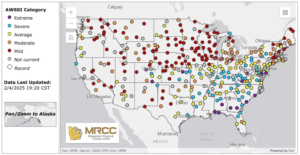
Figure 3. The Accumulated Winter Season Severity Index for the winter of 2024-25 through February 4 shows that the fall and winter thus far have been “extreme” (the highest rating) at a few points near the Gulf Coast, but “mild” (the lowest rating) across most of New England, the Upper Midwest, Northern Plains, and Mountain West. (Image credit: Midwest Regional Climate Center)
Jeff Masters contributed to this post.
MORE LIKE THIS

Extreme weather’s dark aftermath: a rise in domestic violence

Wildlife is slowly returning to Colorado forests that burned in 2020

Climate change is worsening diabetes worldwide
Bob Henson
Bob Henson is a meteorologist and journalist based in Boulder, Colorado. He has written on weather and climate for the National Center for Atmospheric Research, Weather Underground, and many freelance… More by Bob Henson
Jeff Master’s and Bob Henson’s “What Caused the Gulf Coast’s Incredible January Snowstorm?” was first published on Yale Climate Connections, a program of the Yale School of the Environment, available at: http://yaleclimateconnections.org. This work is licensed under a Creative Commons Attribution-Noncommercial-No Derivative Works 2.5 license (CC BY-NC-ND 2.5).
Here are more “ETs” recorded from around the planet the last couple of days, their consequences, and some extreme temperature outlooks, as well as any extreme precipitation reports:
Here is some new January 2025 climatology (More reports are archived on prior daily February 2025 posts.):
Here is More Climate News from Saturday:
(As usual, this will be a fluid post in which more information gets added during the day as it crosses my radar, crediting all who have put it on-line. Items will be archived on this site for posterity. In most instances click on the pictures of each tweet to see each article. The most noteworthy items will be listed first.)