Dear Diary. We had a historic cold wave named Chione for the Greek Goddess of snow in mid-January:
The frigid system was responsible for 23 all-time records, mostly set where historic snow fell across the Gulf coastal area.
Now we have a new influx of Arctic air chilly enough to be declared as at least a major CAT3 cold wave using my system. Since it is coming southward in the wake of what the Weather Channel has dubbed a winter storm system named Kingston, it will get the same name. As is typical for most U.S. cold waves, Kingston will be most brutal across the northern Plains and all of the Upper Midwest. Besides being responsible for much more lake effect snow, Kingston will be cold enough to produce about 1500 daily record lows to be reported in the NCEI system by my estimation. There will also be many monthly records with perhaps some all-time records from stations with short periods in which records have been kept.
During midafternoon on this Monday, we can see the bulk of Kingston located in south-central Canada into Montana and the northern Plains:
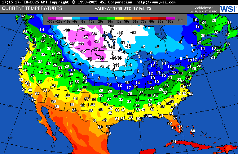
Brutal temperatures near -35°F at night will occur from northeast Montana through North Dakota into northern Minnesota the next couple of days. This was quite typical during colder times during the 20th century, but Kingston reminds us that the climate is not so broken that systems of this magnitude can still occur despite the planet setting average record warm records recently.
This NWS advisory chart looks brutal:
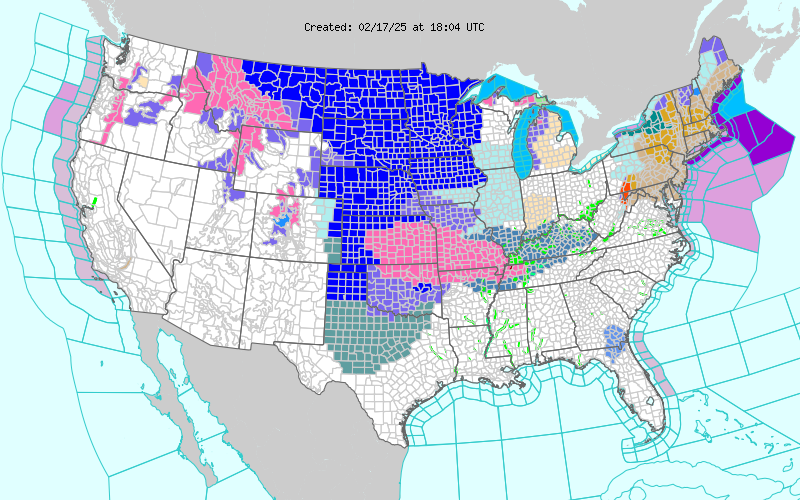
The dark blue color represents where extreme cold warnings have been issued. Pink and light blue colors in the central Plains are winter storm warnings and advisories for Winter Storm Kingston.
Here are more details from the Washington Post:
https://www.washingtonpost.com/weather/2025/02/17/polar-vortex-subzero-cold-forecast-snow-ice-storm
Polar vortex to bring frigid temperatures, snow and ice to millions of Americans
About 60 million people are forecast to experience subzero temperatures. The polar vortex may also fuel yet another snow and ice storm in coming days.
February 17, 2025 at 6:25 a.m.
About 20 states will experience dangerous wind chills lower than minus-20 over the next week. (Ben Noll/The Washington Post/data source: ECMWF)

By Ben Noll
A lobe of the polar vortex, a ring of freezing air typically found near the North Pole, will once again move into the central and eastern states this week, bringing some of the coldest air of the winter season so far — and even helping fuel yet another winter storm in coming days.
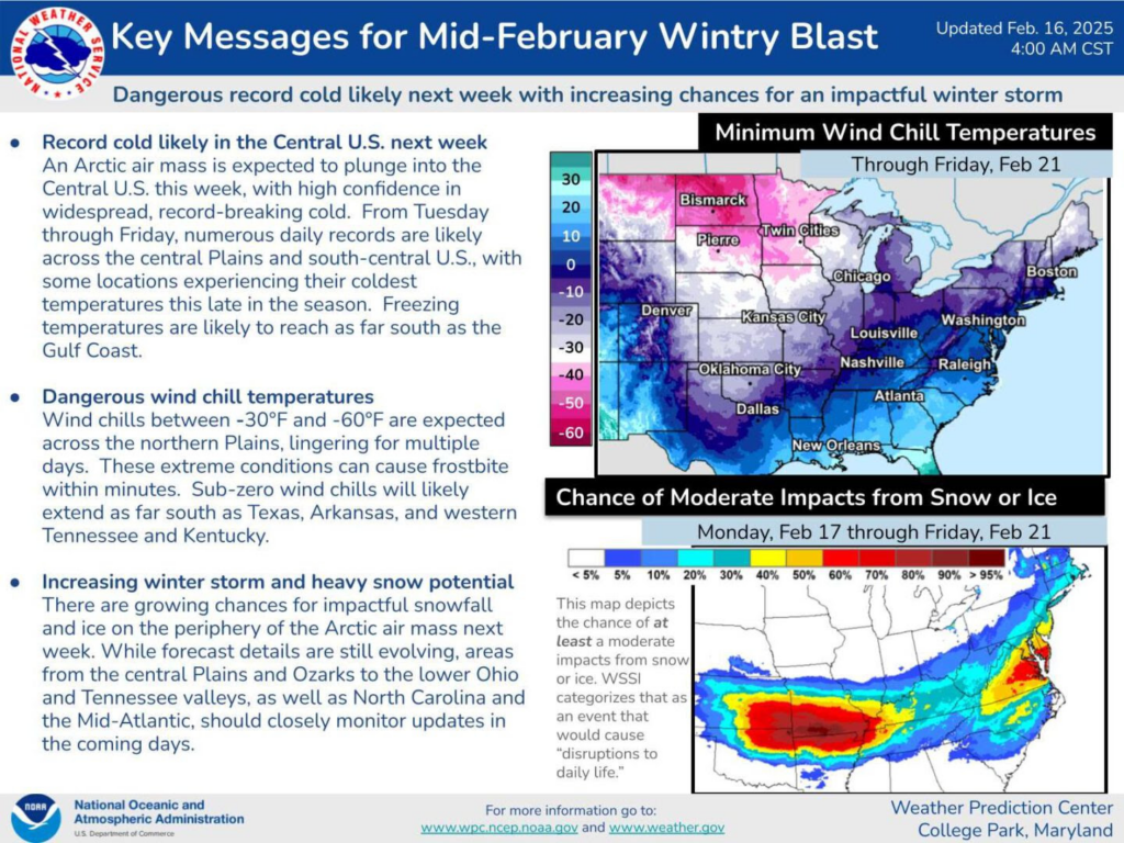
About 60 million people are expected to experience subzero temperatures across the United States, from Montana to Maine and as far south as Oklahoma. About 20 states can expect wind chill values below minus-20, low enough to cause frostbite in less than 30 minutes.
The level of cold may be record-breaking for some central and southern states, especially from Wednesday through Friday.
As the frigid air clashes with a warmer, moist flow of air from the Gulf of Mexico, a storm will form in the Plains on Tuesday and track to the East Coast by Thursday.
A swath of accumulating snow and/or ice will hit more than 15 states. The conditions may lead to treacherous travel, flight delays and cancellations, and more school closures — including in several states that experienced deadly flooding over the weekend.
What to know about the polar vortex
There have been several polar vortex episodes across the United States this winter, with the mass of freezing air surging southward from Greenland and Canada.
This time, the frigid conditions will be made more serious because of the wind, leading to dangerous conditions for people and pets. Wind chills lower than minus-20 are forecast to reach as far south as Oklahoma and Arkansas — frostbite is possible in less than 30 minutes under such conditions.
During January, the vortex brought subzero temperatures to about 105 million people, fewer than the 140 million who experienced such conditions during the notorious January 2014 event.
This week, conditions will be most severe in the central states, where temperatures will be more than 40 degrees below average in the early to middle part of the week.
The freezing air will spill toward the Gulf Coast from Wednesday into Thursday, with temperatures nosediving to more than 30 degrees below average.
Dozens of cities from South Dakota to Alabama may experience record-low temperatures on Thursday.
In total, parts of more than two dozen states are forecast to experience subzero temperatures this week.
Parts of more than two dozen states will experience subzero temperatures this week. (Ben Noll/The Washington Post/data source: ECMWF)
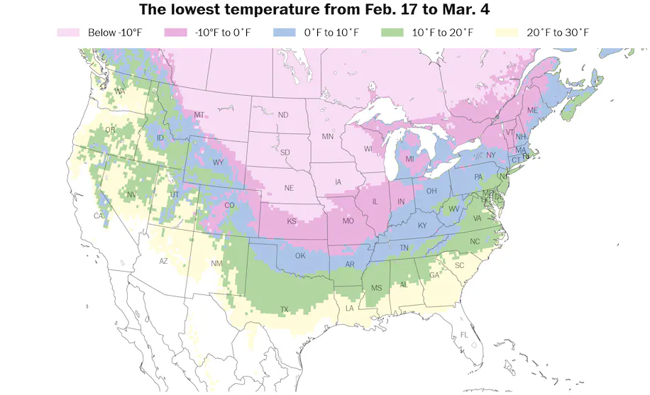
Here’s a breakdown of the lowest forecast temperature in each state and where records may fall.
- Below minus-40: North Dakota
- Below minus-30: Montana and South Dakota
- Below minus-20: Minnesota, Wyoming, Nebraska, Kansas and Iowa
- Below minus-10: Colorado, Missouri, Illinois, Wisconsin, Michigan, New York, Vermont, New Hampshire and Maine
- Below zero: Oklahoma, Arkansas, Kentucky, Indiana, Ohio, West Virginia, Pennsylvania, Connecticut and Massachusetts
- Cities that may experience low temperature records: Rochester, Minnesota (minus-18, Tuesday); Omaha (minus-16, Thursday); Des Moines (minus-11, Thursday); Kansas City, Missouri (minus-13, Thursday); Topeka, Kansas (minus-14, Thursday); Tulsa, Oklahoma (minus-2, Thursday); Amarillo, Texas (5, Thursday); Dallas/Fort Worth (14, Thursday); San Antonio (23, Thursday); Birmingham, Alabama (17, Friday)
The most unusually cold air will push toward the East Coast by the weekend, while conditions become more moderate in central states.
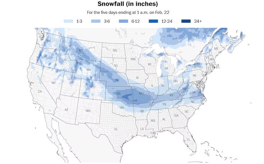
Snow, some heavy, will stretch from coast to coast this week as the polar vortex dives southward. (Ben Noll/The Washington Post/data source: NOAA)
The freezing conditions will be accompanied by yet another winter storm this week, one that could affect parts of the Mid-Atlantic from Wednesday into Thursday. Because of a trend toward a more southerly track, Washington will probably be spared of heavy snow, and there’s a chance the storm may miss the capital entirely.
The storm will generally track along the Interstate 70 corridor in the Plains and Midwest before veering south of there once it reaches the East. Slippery conditions will probably develop along Interstate 95 in Virginia and North Carolina from Wednesday into Thursday.
Here’s a day-by-day breakdown of the states that may experience snow or ice from the storm.
Monday: South Dakota, Nebraska, Iowa and Missouri
Tuesday: South Dakota, Nebraska, Colorado, Kansas, Oklahoma, Texas, Arkansas, Missouri, Illinois, Indiana and Kentucky
Wednesday: Missouri, Arkansas, Louisiana, Mississippi, Alabama, Georgia, Tennessee, Kentucky, Illinois, Indiana, Ohio, West Virginia, Maryland, Washington, D.C., Delaware, Virginia, North Carolina and South Carolina
Thursday: Ohio, Pennsylvania, West Virginia, Kentucky, Tennessee, North Carolina, Virginia, Washington, Maryland, Delaware, New Jersey, New York, Connecticut, Rhode Island and Massachusetts
From Nebraska to Virginia, snowfall amounts of 3 to 6 or 6 to 12 inches are forecast, with winter storm watches, warnings and advisories already covering many states.
A narrow corridor of freezing rain could create dangerous conditions in Oklahoma, northern Texas and Arkansas on Tuesday and northern Louisiana, northern Mississippi, northern Alabama, South Carolina and North Carolina on Wednesday.
Ice amounts may be heavy enough to cause power outages in southeastern North Carolina, including the area between Fayetteville and Wilmington, from late Wednesday into Thursday.
When will it get warmer?
As meteorological spring, which begins on March 1, inches closer, you may be wondering when the polar vortex will retire for the season.
There are signs that temperatures will be on the upswing this weekend into next week, especially across the Plains and Midwest.
After temperatures in the minus-20 range early in the week, temperatures in South Dakota could reach well into the 60s late in the weekend — an 80-degree turnaround.
The most dramatic weather whiplash is forecast to occur near Minot, North Dakota, where low temperatures in the minus-30s this week will rebound to high temperatures well into the 50s early next week — a change of almost 90 degrees.
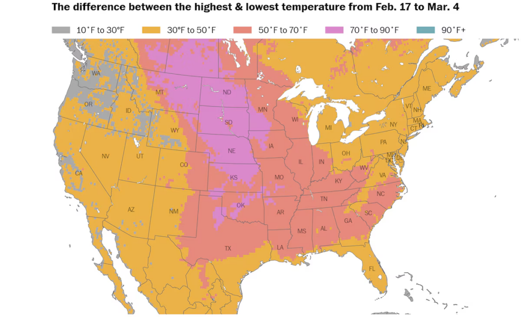
An extreme temperature swing of more than 70 degrees is forecast across the Plains from this week to next week. (Ben Noll/The Washington Post/data source: ECMWF)
The difference between the lowest and highest forecast temperature over the next two weeks may be more than 70 degrees in the following states: Montana, Wyoming, North Dakota, South Dakota, Nebraska, Colorado, Kansas, Oklahoma, Texas, Arkansas, Missouri, Iowa and Minnesota.
Some of the milder air may reach the Eastern Seaboard next week, with a more notable warm-up possible in early March.
Even as temperatures rise, stormy conditions may not be gone for good: Spring is known for its volatile weather, as advancing warm air from the tropics battles with retreating cold air from the poles.
Setting this spring apart from others is a warmer than average Gulf of Mexico, which may fuel dynamic storms, even as the polar vortex departs for the season.
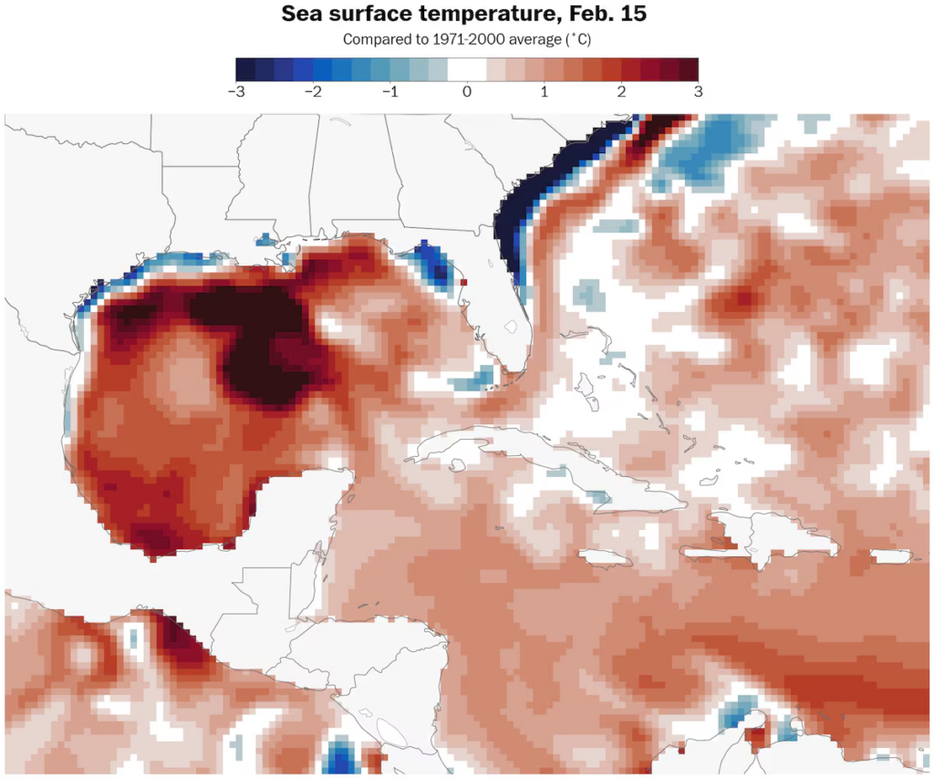
Warmer than average sea temperatures in the Gulf of Mexico could fuel stormy conditions this spring. (Ben Noll/The Washington Post/data source: NOAA)
By Ben Noll Ben Noll is a meteorologist with a passion for communicating the ‘why behind the weather,’ extreme events and climate trends. He has extensive experience working with meteorological data and creating weather graphics on a supercomputer, developing meteorological services in the Pacific Islands, and short, medium and long-range weather prediction. follow on X@BenNollWeather
Here are more “ETs” recorded from around the planet the last couple of days, their consequences, and some extreme temperature outlooks, as well as any extreme precipitation reports:
Here is More Climate News from Monday:
(As usual, this will be a fluid post in which more information gets added during the day as it crosses my radar, crediting all who have put it on-line. Items will be archived on this site for posterity. In most instances click on the pictures of each tweet to see each article. The most noteworthy items will be listed first.)