The main purpose of this ongoing blog will be to track planetary extreme, or record temperatures related to climate change. Any reports I see of ETs will be listed below the main topic of the day. I’ll refer to extreme or record temperatures as ETs (not extraterrestrials).😉
Main Topic: Portions of the Carolinas Continue to Burn
Dear Diary. Just next door to my home state of Georgia, the Carolinas are experiencing another climate change related hardship. A warm/dry winter transitioning to spring has been the impetuous for destructive wildfires, some like recent California fires, which have burned residential areas. The Appalachians that were hit devastated by Helene have had the double whammy of that destructive climate changed system because of new wildfires.
Thankfully, some rain is in the offing for the Carolinas early next week:
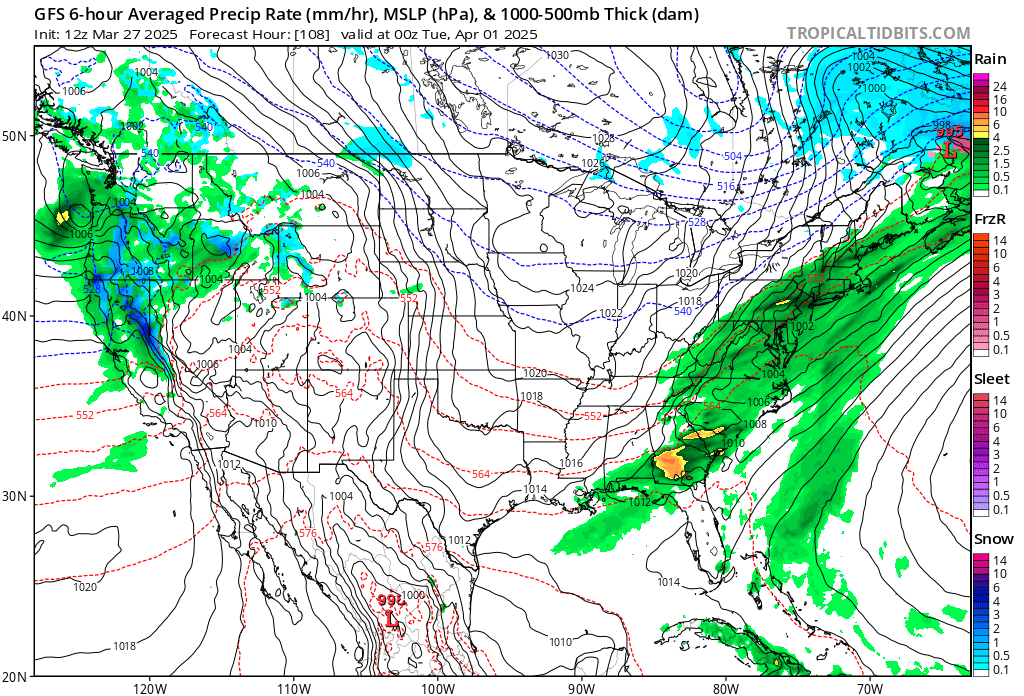
The front producing this shot of much needed rainfall appears to be a quick mover, unfortunately. Will rainfall be enough to quench most of the fires across the Carolinas? Stay tuned.
Here are more details from the Washington Post:
https://www.washingtonpost.com/weather/2025/03/27/wildfires-carolinas-air-quality-smoke-forecast
Wildfires continue to burn thousands of acres in the Carolinas
In total, the largest wildfires are burning more than 12,000 acres across the Carolinas — and the fires are likely to grow further without much resistance in the coming days.
March 27, 2025
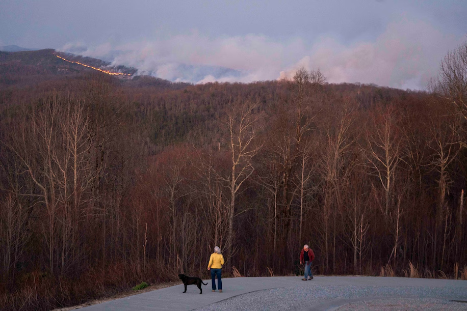
Smoke rises from the Table Rock Fire near the Sassafras Mountain Overlook on March 26 near Rocky Bottom, South Carolina. (Sean Rayford/Getty Images)

Major wildfires that began last week continue to burn through land in western portions of the Carolinas. A newer large fire is also flaring in nearby north Georgia.
In total, the largest wildfires are burning more than 12,000 acres overall — and the fires are likely to grow further without much resistance in the days to come. A new state of emergency was issued Wednesday for a large swath of western North Carolina.
In addition to wildfires, the region is dealing with expansive drought.
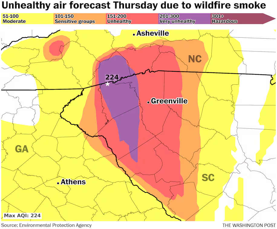
In a challenge for firefighters, wind shifts around cold fronts that are passing through the region are also sending wildfire smoke far beyond the areas impacted by flames. The air on Thursday will be particularly tough, with Code Purple conditions that denote a “very unhealthy” air forecast for several counties in North and South Carolina.
There could be some rainfall by Sunday, but amounts are uncertain.
The latest on the fires
North Carolina Gov. Josh Stein (D) declared a state of emergency late Wednesday to coordinate the ongoing fire response. The order covers nearly three dozen of the state’s 100 counties.

“The wildfires in western North Carolina continue to grow, so I have expanded our State of Emergency,” Stein said in a press release.
The largest fires in Polk County have come under partial containment while surpassing 6,000 acres. Several are burning in the mountains east of Hendersonville, which is roughly 25 miles south of Asheville.
Most concerning of the group — and No. 1 in the United States — is the Black Cove Complex. More than 500 crew members had responded as of late Wednesday, with more on the way. A firefighter was injured Tuesday on the front lines, and a second straight day of intense fire behavior was reported Wednesday.
Evacuation orders were extended from parts of North Carolina’s Polk County to Henderson County. So far, they are mainly in rural locations, according to local officials.
As of a Wednesday evening update from state officials, the Black Cove Fire had burned 3,052 acres and was 17 percent contained.
At the nearby Deep Woods Fire — 3,231 acres and 11 percent contained — firefighters were working to protect structures on the fire’s southern flank and addressing spot blazes that developed during strong gusts.
South Carolina, where a state of emergency is also in effect, has also experienced a rapid fire growth in recent days.
The largest, called Table Rock, had burned more than 4,500 acres Wednesday night with zero percent containment. This fire is burning around 20 miles northwest of Greenville, South Carolina, just south of the North Carolina border.
In addition to threatening homes in Pickens and Greenville counties in that state, the Table Rock Fire was also threatening Transylvania County in North Carolina, where new rounds of evacuations were ordered Wednesday.
The nearby Persimmon Ridge Fire was past 1,500 acres and also zero percent contained.
Just across the border in northern Georgia, the Big Ridge Fire burning in the remote Warwoman Wildlife Management Area grew beyond 1,100 acres by early Thursday. This fire began last Saturday and rapidly grew Tuesday and Wednesday amid red flag warnings.
Statewide burn bans remain in place for both North and South Carolina.
The immediate concerns
Very unhealthy air is forecast Thursday for Transylvania County in North Carolina as smoke from fires hovers in the area. The Code Purple extends across the border into South Carolina.
Greenville, South Carolina, is likely to see Code Red “unhealthy” air through the day. Haze and smoke have been observed at a Weather Service station there from Wednesday afternoon through at least Thursday morning, including lowered visibility down to several miles at times.
Another dozen counties downwind from the major fires are dealing with similar conditions.
Fires are likely to continue to burn effortlessly Thursday. There is also abundant fuel in place from downed trees, as the fires run through areas impacted by Hurricane Helene six months ago.
Most of the high-elevation region has yet to see significant spring greening, which can combat fire spread. Despite historic rainfall during Helene, drought has taken hold, with winter rainfall helping but not fully defeating fire-friendly conditions.
“Thursday afternoon will again be very dry, with minimum relative humidity in the 15-20% range across most of the region,” warned the National Weather Service office in Greenville-Spartanburg, South Carolina.
Although winds may be somewhat lighter compared to Tuesday and Wednesday, when areas of rapid fire spread occurred, enhanced risk was still anticipated. Similar conditions are also forecast Friday and into at least Saturday before an increased chance of rain amid rising moisture in the region.
What’s ahead
While there is some hope for rain in coming days, there are questions as to how much will fall. This is because a storm track will likely favor low-pressure areas moving well northwest of the Southeast U.S., which would favor areas northwest of the fires for the most rain. That may be somewhat offset by more frequent chances thanks to multiple storm systems passing by. As much as half an inch could fall by Sunday.
Winds around the any storm systems could exacerbate concerns ahead of and behind any cold fronts passing by. Temperatures are additionally expected to mostly be above to well above average, which can create further firefighting difficulties but may also help speed up spring green in the region.
By Ian Livingston Ian Livingston is a forecaster/photographer and information lead for the Capital Weather Gang. By day, Ian is a defense and national security researcher at a D.C. think tank.
Here are more “ETs” recorded from around the planet the last couple of days, their consequences, and some extreme temperature outlooks, as well as any extreme precipitation reports:
Here is More Climate News from Thursday:
(As usual, this will be a fluid post in which more information gets added during the day as it crosses my radar, crediting all who have put it on-line. Items will be archived on this site for posterity. In most instances click on the pictures of each tweet to see each article. The most noteworthy items will be listed first.)