The main purpose of this ongoing blog will be to track planetary extreme, or record temperatures related to climate change. Any reports I see of ETs will be listed below the main topic of the day. I’ll refer to extreme or record temperatures as ETs (not extraterrestrials).😉
Main Topic: An Update on Horrific Week of Severe U.S. Storms
Dear Diary. As expected, a week of severe storms, some of which are producing tornadoes, is ongoing with flooding now a big concern for the nation’s mid-section:
Spring severe weather is quite common but rounds upon round going across the same general area is not. A blocky jet stream pattern with record warmth to the south of the front, which is fueling the system, are two climate change related items to consider here.
Round one from this spring setup on Wednesday and Wednesday Night was quite prolific and horrific, producing numerous tornadoes from Arkansas into Tennessee and Kentucky. Here is an update from the Washington Post:
At least four killed in Central U.S. as tornado and extreme flood risk continues
After swarms of overnight tornadoes, a destructive weather event will continue for millions of people, with the marathon storm persisting until Sunday.
Updated April 3, 2025 at 12:07 p.m. EDT today at 12:07 p.m. EDT
Several tornadoes were spotted across the Mid-South states on April 2, including in Arkansas and Missouri, as a large storm system moved through the region. (Video: The Washington Post)
By Ruby Mellen, Scott Dance and Ben Noll
A destructive storm continued for millions of people across the Mid-South on Thursday, killing at least four people as tornadoes, high winds and rainfall caused damage and flooding across numerous states.
Three fatalities occurred in Tennessee and one in Missouri, according to state officials.
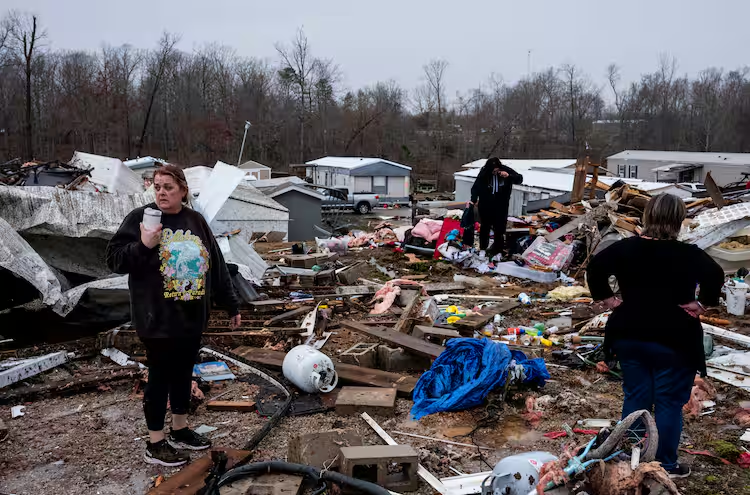
One death occurred in the middle of the night when the victim’s home in Fayette County, Tennessee, was flipped upside down, according to the county’s Emergency Management Agency.
The National Weather Service in Memphis said it would investigate damage from overnight storms in Lake City, Arkansas, and Selmer, Tennessee, on Thursday as part of surveys to potentially confirm tornadoes and assess their size and strength.
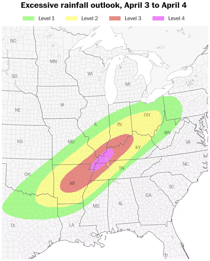
A rare high-risk warning for excessive rainfall — the highest level issued by the National Oceanic and Atmospheric Administration — covers parts of five states Thursday, with the corridor including Memphis and Jackson in Tennessee, and Jonesboro in Arkansas.
In some parts of Tennessee, reports of flooding had begun to emerge Thursday morning. In Nashville, for example, 3.02 inches of rain had fallen at the airport since early that morning, compared to the typical total April average of about 4 inches.
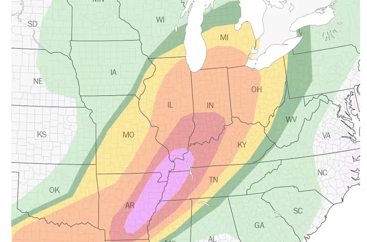
While strong tornadoes aren’t expected to be as widespread Thursday as they were Wednesday, an enhanced risk (Level 3 out of 5) for severe thunderstorms covers 4 million people across seven states, from northeastern Texas to western Tennessee.
The Weather Prediction Center called it a “prolonged, life-threatening flash flood event” with “major flooding” expected.
As of early Thursday, there had been more than 450 reports of severe weather from Texas to Michigan, including more than 25 preliminary reports of tornadoes, damaging winds and, in some communities, hail the size of baseballs.
More than 280,000 customers were without power from Mississippi to Michigan on Thursday morning. More outages will probably occur later Thursday as strong storms redevelop.
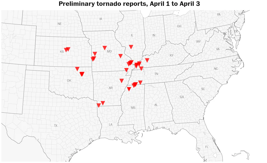
From Tuesday to Thursday, there have been more than three dozen preliminary tornado reports. The number of reported tornadoes is expected to increase. (Ben Noll/The Washington Post/data source: NOAA/SPC)
On Wednesday evening, storm chasers got extremely close to a dangerously strong vortex that tore through Lake City, Arkansas. The northern suburbs of Indianapolis were struck by a damaging tornado Wednesday night, which reportedly caused a warehouse to partially collapse and seemingly flooded parts of the city.
Early Thursday, the tornado risk shifted eastward. While tornado reports have not been confirmed, the communities of Selmer and Bethel Springs in Tennessee, may have been hit by a pair of them a little more than two hours apart. Storms accompanied by tornado warnings then passed near Nashville as tornado sirens rang out across the city.
States of emergency have been issued for Kentucky, Tennessee and Arkansas, while an executive order by the governor to activate the National Guard was signed in Missouri.
More on extreme weatherNext:
Potentially catastrophic storms and tornado threats begin in central U.S.
March was an active month for tornadoes, again. Here’s why.
Where days of flooding rains, tornadoes and heavy snow will hit hardest
The extreme weather threat will continue in the central states until early Sunday before shifting east, as rounds of intense rain and possible severe thunderstorms are set to lash areas from Texas to Ohio.
Nashville was under a flash flood warning Thursday after the city saw heavy rains overnight and into the morning. The city’s Emergency Operations Center posted images and video of its crews braving waist-deep waters to conduct rescues.
Additional rounds of flooding are more likely in areas that experienced heavy rainfall and flooding Wednesday because the ground is saturated.
“With more severe weather and increasing flooding the next few days, we are not able to immediately survey all the damage, as our focus will remain on warning operations,” Darone Jones of the Weather Service in Memphis said Thursday. He said the agency would deploy teams to assess damage or any areas with reports of storm-related fatalities.
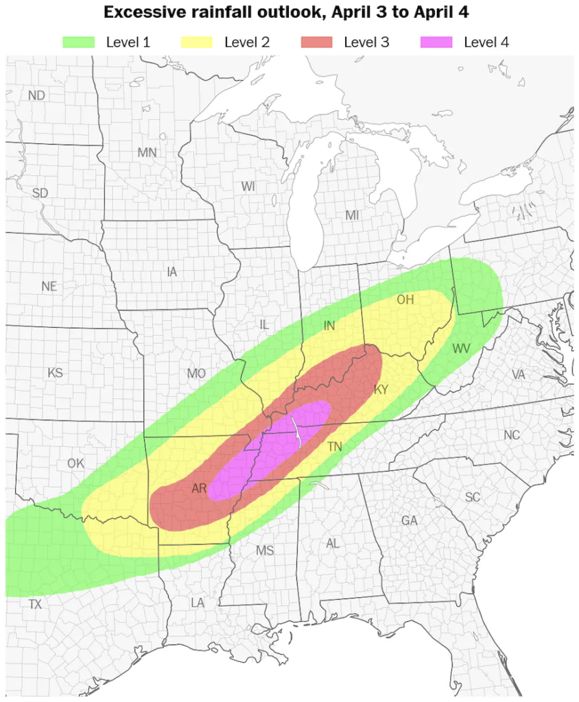
A moderate risk (Level 3 out of 4) for excessive rainfall covers more than 9 million people from Arkansas to Ohio, while a high risk (Level 4 out of 4) is in effect for more than 2.5 million people in eastern Arkansas, northern Mississippi, western Tennessee, southeastern Missouri and western Kentucky.
Rainfall amounts of up to 6 inches are possible in the hardest-hit areas, with river flooding possible or likely across several states.
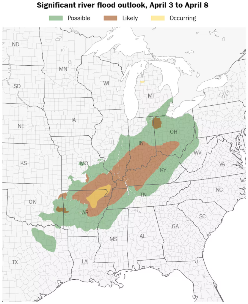
Significant river flooding is possible or likely across several states during the days ahead. (Ben Noll/The Washington Post/data source: NOAA/RFC)
The threat Thursday of severe thunderstorms will be widespread, covering a 1,500-mile stretch from northern Texas to central Pennsylvania, including the nation’s capital.
An enhanced risk (Level 3 out of 5) for severe thunderstorms covers parts of southeastern Oklahoma, northeastern Texas, Arkansas, far northern Louisiana, northern Mississippi, western Tennessee and far southeastern Missouri, home to more than 4 million people.
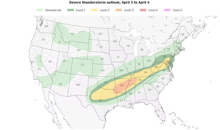
An enhanced risk (Level 3 out of 5) for severe thunderstorms covers parts of seven states on Thursday, while a slight risk (Level 2 out of 5) for severe thunderstorms stretches from Texas to Pennsylvania. (Ben Noll/The Washington Post/data source: NOAA/SPC)
While the tornado threat won’t be as high as it was Wednesday, the Storm Prediction Center says strong tornadoes will again be possible, primarily in a corridor from far northeastern Texas to southwestern Tennessee.
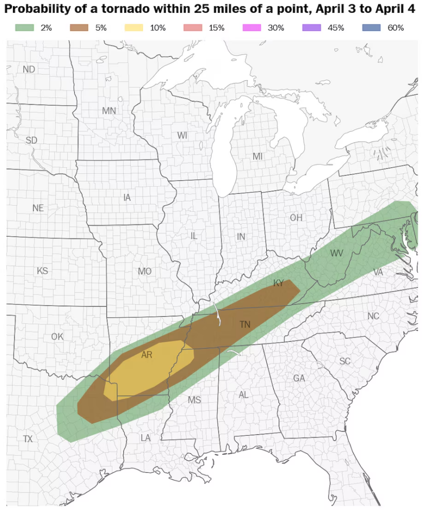
The highest tornado risk on Thursday stretches from northeastern Texas to southwestern Tennessee and includes much of Arkansas. (Ben Noll/The Washington Post/data source: NOAA/SPC)
On the cold side of the storm, more than a foot of snow had fallen in northern Minnesota as of early Thursday. Snow amounts of 4 to 8 inches were common across the region, extending westward into the Dakotas.
The snow will end there early Thursday, but wintry weather will develop across northern New England, where freezing rain will make for dangerous travel conditions.
How long will the storm last?
The threat for excessive rainfall and severe thunderstorms will continue into the weekend across the Mid-South because of an “atmospheric traffic jam” causing the storm to hit the same areas time and time again.
On Friday, the risk for flooding rainfall will be highest from northeastern Texas to southern Indiana — farther west than Thursday’s risk area.
Severe thunderstorms are expected to threaten the same corridor, with tornadoes again possible.
From Saturday into early Sunday, a high risk for excessive rainfall returns to many of the same areas that were hit hard Wednesday and forecast to be significantly affected Thursday — an area extending from eastern Arkansas to southern Indiana.

A moderate to high risk for excessive rainfall continues through Sunday. (Ben Noll/The Washington Post/data source: NOAA/WPC)
By the time the storm is done, more than a foot of rain probably will have fallen in some areas.
The system will shift toward the Eastern Seaboard on Sunday as the threat eases across the central states.

By Ruby Mellen Ruby Mellen reports on climate change and the environment for the Washington Post. follow on X @rubymellen

By Scott Dance Scott Dance is a reporter for The Washington Post covering extreme weather news and the intersections between weather, climate, society and the environment. Send him news tips via Signal at @ssdance.22.follow on X @ssdance

By Ben Noll Ben Noll is a meteorologist with a passion for communicating the ‘why behind the weather,’ extreme events and climate trends. He has extensive experience working with meteorological data and creating weather graphics on a supercomputer, developing meteorological services in the Pacific Islands, and short, medium and long-range weather prediction. follow on X @BenNollWeather
Here are more “ETs” recorded from around the planet the last couple of days, their consequences, and some extreme temperature outlooks, as well as any extreme precipitation reports:
Here is More Climate News from Thursday:
(As usual, this will be a fluid post in which more information gets added during the day as it crosses my radar, crediting all who have put it on-line. Items will be archived on this site for posterity. In most instances click on the pictures of each tweet to see each article. The most noteworthy items will be listed first.)