The main purpose of this ongoing blog will be to track planetary extreme, or record temperatures related to climate change. Any reports I see of ETs will be listed below the main topic of the day. I’ll refer to extreme or record temperatures as ETs (not extraterrestrials).😜
Main Topic: Hurricane Melissa- The Next Western Hemisphere Climate Crisis Tragedy After Palisades Fire for 2025
Dear Diary. After the horrific January Southern California Palisades fire there hasn’t been a big climate change related incident the rest of this year across the Western Hemisphere. Yes, there have been historic heatwaves, but none causing thousands of deaths at any one time. That might unfortunately change because Hurricane Melissa is bearing down on Jamaica.
Melissa has all the hallmarks of a climate change influenced hurricane. The Caribbean is at record warm levels, and the system has responded, undergoing rapid intensification since Saturday.
As of this Sunday it appears that Jamaica will get a direct strike from Melissa as a CAT4 or even a devastating CAT5 system. That would mean that Jamaica will experience the worst hurricane in its history. This situation reminds me of what happened to Puerto Rico in 2017 due to a CAT4 direct strike from Maria. That system killed more than 3,000 people. It took years for Puerto Rico to recover.
I can never forget the image of old President Trump throwing out rolls of paper towels to poor Puerto Rican residents enduring that climate crisis after Maria struck. I fear something similar will happen to Jamaica early this week unless Melissa can bypass the island nation by going much further west than forecast. And this time I bet that the U.S. under Trump’s leadership won’t even bring paper towels for Jamica for aid because of his America First policy.
Here are more details from the Washington Post:
Why Melissa’s intensification en route to Jamaica is so extraordinary – The Washington Post
Why Melissa’s intensification en route to Jamaica is so extraordinary
Hurricane Melissa threatens to make a direct strike on Jamaica as the most powerful storm in its history. See how strong it will become and where it’s headed.
October 26, 2025 at 6:56 a.m. EDT

Satellite imagery shows Melissa rapidly intensifying from a tropical storm to a major hurricane between Saturday and Sunday. (Ben Noll/The Washington Post; data source: NOAA)
By Ben Noll, Ruby Mellen, Brady Dennis and Matthew Cappucci
Jamaica is bracing for destruction as a rapidly intensifying Hurricane Melissa inches closer, threatening to make a direct strike as the most powerful storm to hit the nation in its history. The storm is expected to reach the main island as a Category 4 or 5 hurricane late Monday into early Tuesday.
Melissa, which was a tropical storm early Saturday, explosively strengthened into a Category 4 monster early Sunday — and it was still intensifying.
The storm will cause catastrophic flooding and landslides, exacerbated by its slow movement and Jamaica’s mountainous terrain. Up to 40 inches of rain as well as destructive winds and 9 to 13 feet of storm surge are expected leading up to and during landfall — probably including the area near the capital city of Kingston.
“Seek shelter now. Damaging winds and heavy rainfall today and on Monday will cause catastrophic and life-threatening flash flooding and numerous landslides before the strongest winds arrive Monday night and Tuesday morning,” the National Hurricane Center wrote in an update early Sunday.
The center said extensive infrastructural damage, long-duration power and communication outages and isolation of communities are expected.
And it’s possible Melissa could make three landfalls in fewer than three days.
In addition to Jamaica, home to about 2.8 million people, dangerous rain-related impacts from Melissa will also continue to be felt in Haiti, where at least three people have died according to local reports, as well as the Dominican Republic. Then the strong storm will strike eastern Cuba late Tuesday into Wednesday as a major hurricane, followed by the southern Bahamas and Turks and Caicos Islands from Wednesday into Thursday.
Hurricane Melissa hazardous wind forecast
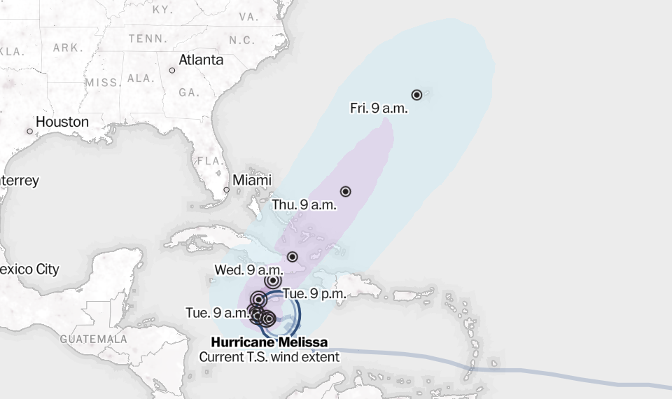
Sustained winds are at least 74 mph for hurricanes and 39 mph for tropical storms. All times Eastern. Source: National Weather Service (DYLAN MORIARTY, ADITYA JAIN, AND SZU YU CHEN/THE WASHINGTON POST)
Melissa’s power is particularly notable. If the storm reaches Category 5 strength as predicted, it will become the third such storm to do so this Atlantic season — the second-highest total for any season on record and part of a trend toward more intense storms.
Melissa is churning across some of the warmest ocean waters in the world, which are also warmer than average, fueling violent thunderstorms that are efficiently converting oceanic heat and moisture into powerful updrafts — a process that accelerated Melissa’s strengthening and led to the formation of a clear, symmetric eye.
The system is unlikely to directly affect the United States, guided out to sea by another storm near the East Coast next week, but some of its moisture could surge into New England and Atlantic Canada, contributing to late-week downpours.
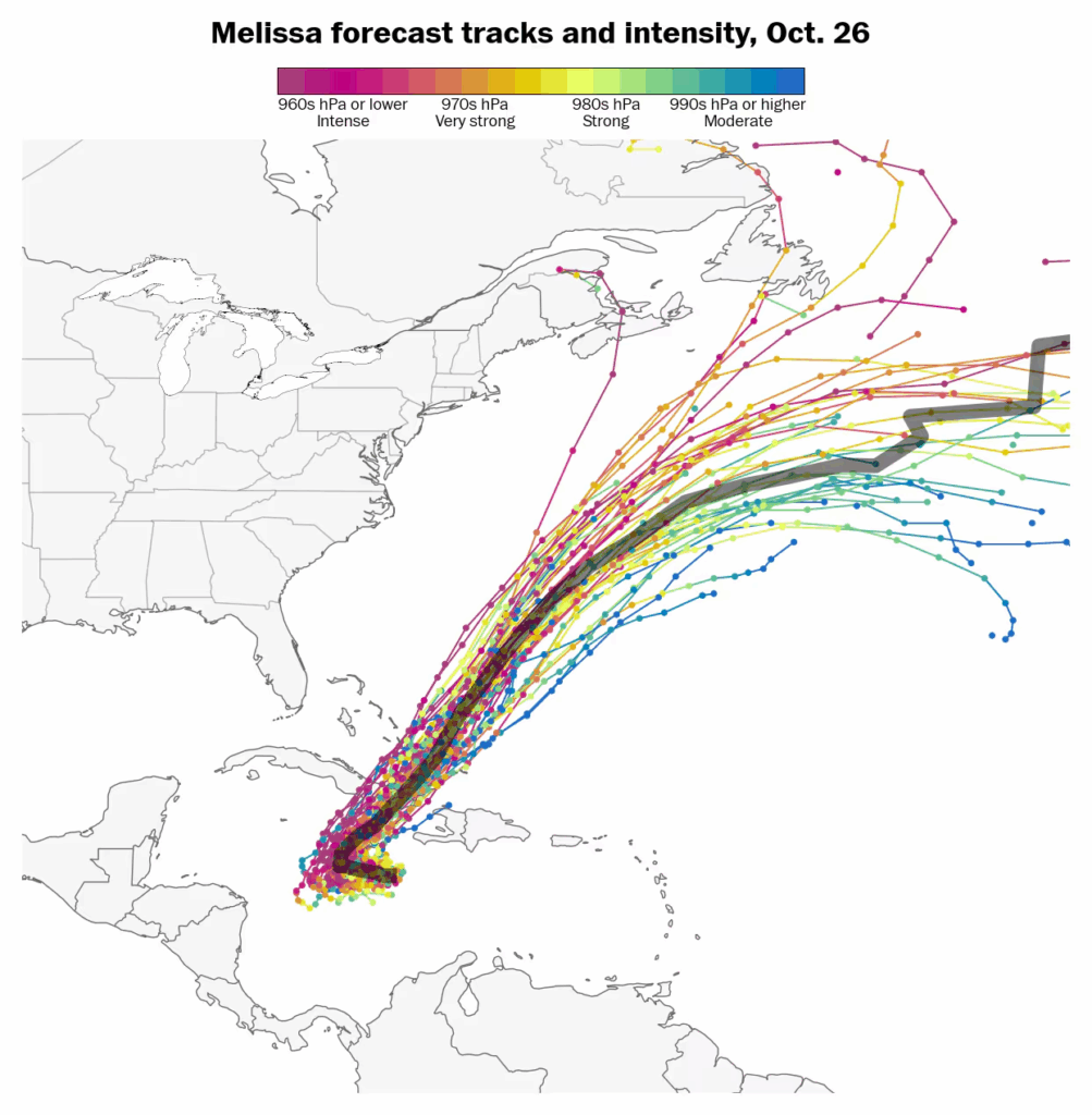
Hurricane Melissa is forecast to make landfall in several places as it travels north over the next week, including Jamaica and eastern Cuba, probably followed by the Bahamas. It will most likely miss North America. Each line indicates a possible forecast track, color-coded by strength. The black line represents the middle outcome of all of the colored lines. (Ben Noll/The Washington Post; data source: ECMWF)
Melissa now a major hurricane
Melissa was a Category 4 hurricane early Sunday, with sustained winds of 140 mph and higher gusts.
A day ago, Melissa had winds of 70 mph — which means it easily surpassed the threshold of 35 mph over 24 hours for a rapidly intensifying system.
In fact, Melissa’s pace of strengthening was twice the rate needed to qualify as rapid, making the storm extraordinary.
Thunderstorms blossoming near the core of Melissa released heat energy to the surrounding environment, warming the surrounding air and helping it to rise. That lifts air away from the surface, meaning there’s simply less air present in the middle of the storm. Less air means less air pressure. That missing air creates a void of sorts; air rushes in from outside the storm to fill that void. That’s where wind comes from — the more dramatic the deficit of air, the stronger the winds.
In Melissa’s case, about 6 to 7 percent of the atmosphere’s ambient mass is missing from the storm’s center. As that deficit grows, winds will further strengthen.
Early Sunday, Melissa was about 120 miles southeast of Kingston and 280 miles southwest of Port-au-Prince, Haiti, lumbering along to the west at 5 mph. Its strengthening had slowed, or even plateaued. That’s to be expected as hurricanes don’t intensify linearly, but rather in fits and bursts. It will probably begin to intensify abruptly on Sunday evening.
Melissa spent part of Saturday drifting slightly south of due west. (Some meteorologists refer to southward-drifting storms as “gold-diggers,” since their digging, or southward, motion can bring them closer to extremely warm waters.) Indeed, Melissa now has slightly longer to spend over the warmest waters of the Atlantic and intensify further.
Hurricane warnings covered all of Jamaica, while watches were in effect for southern Haiti and the four easternmost provinces of Cuba. Tropical storm warnings also covered southern Haiti.
On Sunday morning, the Hurricane Hunters found Melissa’s eye to be 16 degrees warmer than the surrounding air outside the eye. Hurricanes are warm-core systems reminiscent of chimneys. The column of exceptional warmth at the center is a sign of an intense storm.
According to a weather model from Google, the storm has more than an 80 percent chance of intensifying into a Category 5 hurricane. The storm may fluctuate in intensity late Monday into Tuesday, so it’s unclear if it will be a Category 4 or 5 at landfall. Regardless, severe impacts are inevitable.
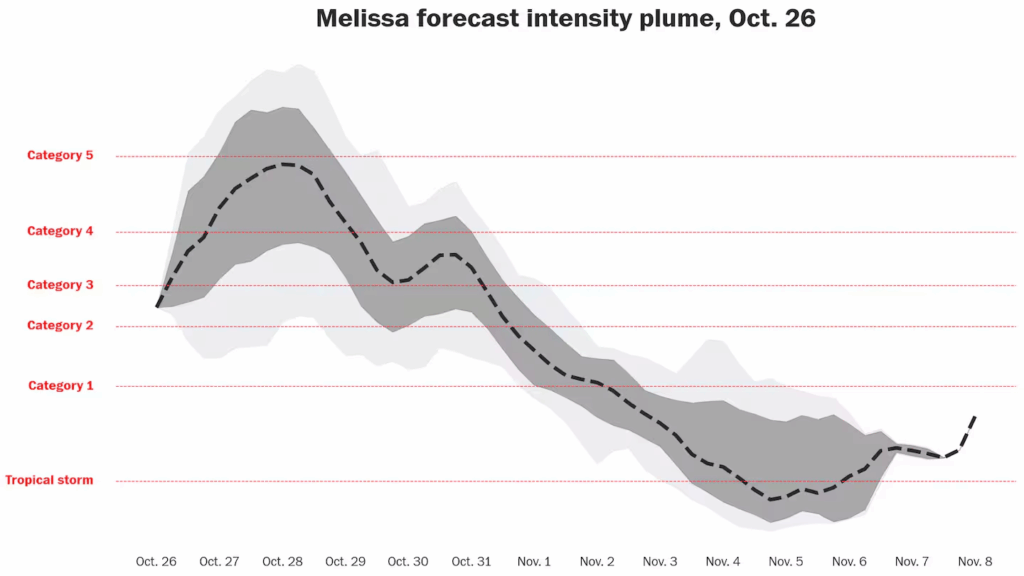
Hurricane Melissa will probably peak at Category 5 intensity before making landfall in Jamaica on Monday. Category 5 hurricanes feature maximum sustained winds of at least 157 mph near their center. (Ben Noll/The Washington Post; data source: Google/DeepMind)
Life-threatening flash flooding, landslides and storm surge will probably hit southeastern Cuba on Tuesday, before the southern Bahamas and Turks and Caicos are lashed on Wednesday.
Why Melissa is so concerning
A slow, lumbering storm like Melissa is cause for great concern.
“In many cases, it’s a worst-case kind of scenario,” said Jeff Masters, a meteorologist who writes on climate change and weather for Yale Climate Connections and for years served with NOAA’s Hurricane Hunters.
A storm that inches along can subject places in its path to longer stretches of torrential rainfall, sustained winds and heightened storm surge. With Melissa, Masters said, he worries about the potential rainfall most of all.
Jamaica, for instance, is not especially susceptible to storm surge, though the airport in Kingston is low-lying and at risk of flooding, Masters said. In addition, he said, many structures on the island were rebuilt to withstand stronger wind speeds after the devastation of Hurricane Gilbert in 1988.
But, Masters said, the island is home to steep terrain that can be conducive to flash floods and mudslides.
Because tropical cyclones thrive on warm water, a storm that lingers in one spot can sometimes stir up cooler, deeper water and eventually weaken itself. But Masters pointed out that in parts of the region where Melissa is set to crawl along, the waters are 86 degrees as far as 200 feet below the surface.
“Unfortunately,” he said, “it’s over a part of the Caribbean that has deep, warm water.”
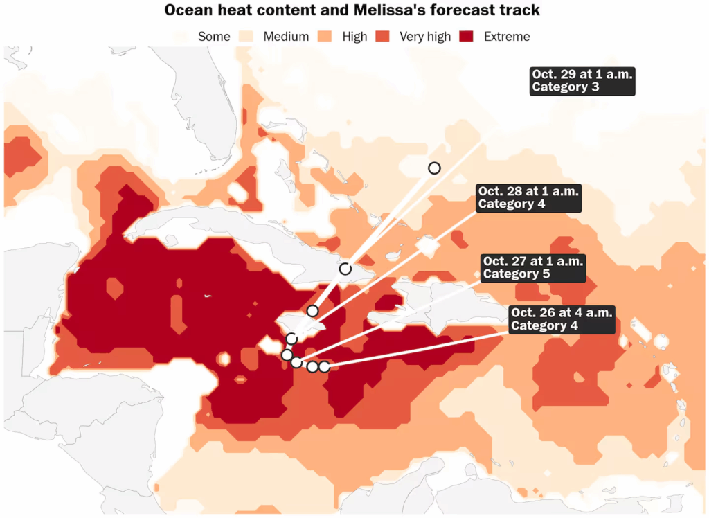
Melissa’s journey over extremely high ocean heat are powering it toward Category 5 strength. (Ben Noll/The Washington Post; data source: NOAA/CoastWatch)
Jim Kossin, a retired NOAA climate scientist and hurricane expert, said that while it is clear climate change is making the strongest storms even stronger, researchers are continuing to investigate whether the planetary changes are also leading to more slow-moving storms that dump huge amounts of rain.
“There is a lot of observational evidence that this is happening more often now,” Kossin said.
He noted that Hurricane Harvey, which dumped as much as 5 feet of rain in parts of the Houston region in 2017, is “the poster child” of what is possible when a large storm stalls. “The whole area was just absolutely inundated with rainfall. The rain just kept falling in the same place.”
He, too, expressed worry about the multiple feet of rain that could fall on Jamaica, saying the mountains can make for “compounding events” such as flash flooding and mudslides that are as unpredictable as they are destructive and deadly.
“That’s the really scary part of these things,” Kossin said.
A benign season no more
Until Melissa, this year saw “one of the most benign hurricane seasons in a long time,” said Phil Klotzbach, a senior research scientist for the Department of Atmospheric Science in the Walter Scott Jr. College of Engineering at Colorado State University.
Over the summer, several monster storms have formed in the ocean and slowly crept toward land before hooking and swiveling back out to sea.
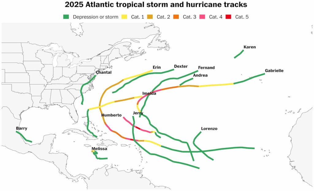
Melissa is the 13th named storm of the Atlantic season and the fourth major hurricane. (Ben Noll/The Washington Post; data source: NOAA)
It’s been a lucky stretch as hurricanes trend toward becoming more powerful and destructive.
Melissa is set to break that quiet streak amid prime conditions for a formidable storm.
“I think our luck is going to run out,” Klotzbach said.
Here are more “ETs” recorded from around the planet the last couple of days, their consequences, and some extreme temperature outlooks, as well as any extreme precipitation reports:
Here is More Climate News from Sunday:
(As usual, this will be a fluid post in which more information gets added during the day as it crosses my radar, crediting all who have put it on-line. Items will be archived on this site for posterity. In most instances click on the pictures of each tweet to see each article. The most noteworthy items will be listed first.)