The main purpose of this blog will be to track planetary extreme, or record temperatures related to climate change. Any reports I see of ETs will be listed below the main topic of the day. I’ll refer to extreme or record temperatures as ETs (not extraterrestrials).😜
Main Topic: Alaska’s Record Cold Trapped by Changing Climate Jet Stream
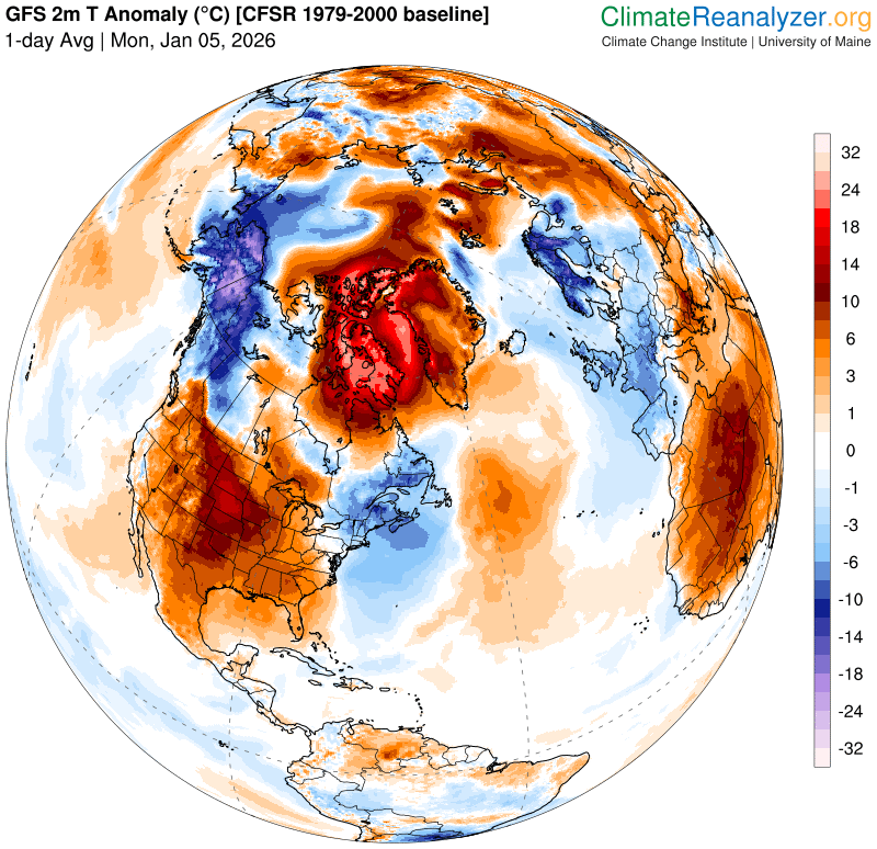
Dear Diary. This winter we have yet another example of a convoluted polar vortex affected by warm pocket anomalies pushing northward into the Arctic region. These warm pockets are trapping residual cold areas, in this one instance not allowing cold air to move southward into the bulk of North America. This weather pattern has produced the coldest temperatures in Alaska since 1980 and yet another near record warm December for the third year in a row across the lower 48 states. This is another example of what climate scientist Dr. Jennifer Francis has pointed to in association with the jet stream in winter bring affected by our long-term carbon pollution.
Last year we had warm pockets trapping a cold pocket over the lower 48 states in January. In 2026 we are seeing the opposite effect.
The same weather pattern has persisted into January as depicted by the following Pivotal Weather chart from this morning:
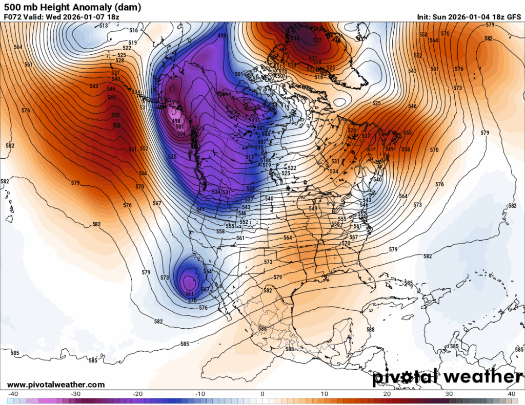
A cold anomaly over Alaska is surrounded by warmth. That has produced very warm conditions close to the surface over most of North America with cold anomalies over Alaska and the Yukon of Canada:
Here is Rick Thoman’s report concerning record cold December weather in Alaska:
Alaska December 2025 Temperature Summary – by Rick Thoman
Alaska December 2025 Temperature Summary
Coldest December in decades
Jan 03, 2026
December 2025 was a month of weather and climate extremes in Alaska. I’ve written about the four-day wind storm in the Mat-Su valley here, the cold snap through Christmas here, and the historic Southeast Alaska snowfall here. This post focuses on the (continuing) long duration cold snap as reflected in the complete December data. I’ll have an explanation of “why” in the upcoming December 2025 Arctic summary.
Monthly average temperatures
December was the coldest month since January 2012 over most of the central and eastern Interior and the coldest December since 1980. The lowest average temperatures occurred in the Alaska-Yukon borderlands and on the Yukon Flats, though were still quite low as far west as middle Yukon and Koyukuk River valleys.
In Southcentral and southwest Alaska this was generally the coldest December since 2010 but the coldest month only since January 2020 (or in some cases January 2024).
Prior to the extreme snowfall it was quite cold over Southeast, and Juneau Airport finished up with the coldest December since 1964 and the coldest month since January 1996. Farther south though it was not nearly as extreme, with this being the coldest December only since 2021 at Sitka, Petersburg and and Ketchikan.
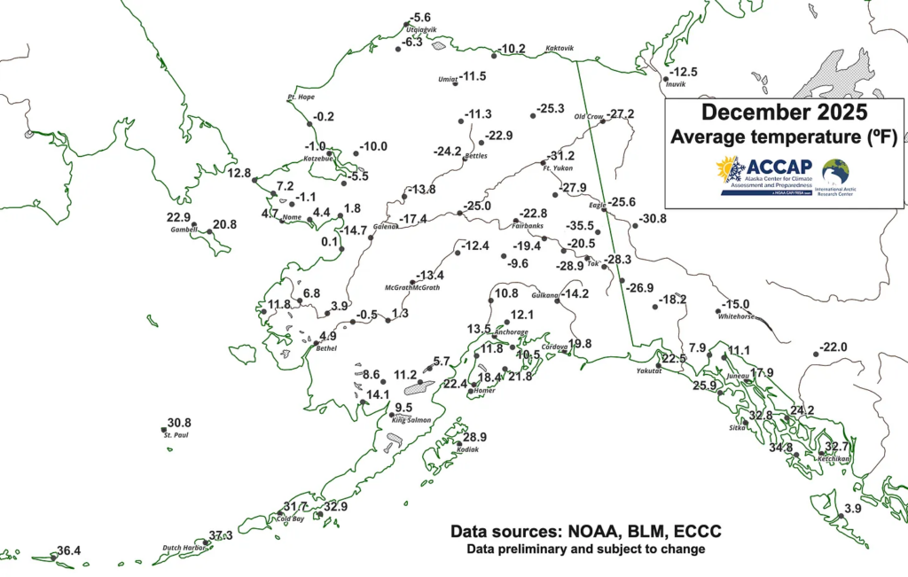
Fig. 1 December 2025 monthly average temperatures (°F). Data from NOAA/NWS, FAA, BLM and ECCC.
At this scale it’s not possible to depict the large variation in temperatures that occur in short distances during the winter months in many parts of northwest North America. For Fig. 1, where there are multiple places with reliable observations, I plot either the official climate site, e.g. Anchorage, Fairbanks and Utqiaġvik, or the long-term climate site from cooperative observers, e.g. Tok, Denali National Park Headquarters and Eagle.
In Southcentral, December had considerable low-elevation temperature variability due to the proximity to Cook Inlet and the local frequency of significant wind, e.g in the Anchorage area, monthly average temperatures ranged from 13.5°F at Anchorage International Airport to 5.8°F at Ft. Richardson in northeast Anchorage. In the Interior, mid-winter average temperatures are always strongly modulated by elevation and this month was no exception. In the Fairbanks area, December average temperatures ranged from -23.7°F at North Pole to -8.7°F at Keystone Ridge, northwest of town at 1600 ft MSL. Wind is also locally a factor in the Interior, e.g. the Delta Junction area, where the Clearwater Lake area is often calmer and much colder than areas closer to the Delta River.
Average temperatures for the month were lower than the 1991-2020 normal over most of Alaska and northwest Canada, with some sites 20°F or more below normal (Fig. 2). The exceptions were the North Slope, the lower Alaska Peninsula and Aleutians/Pribilof Islands and and the Bering Sea coast west of about 165°W. St. Lawrence Island in the northern Bering Sea was especially mild.
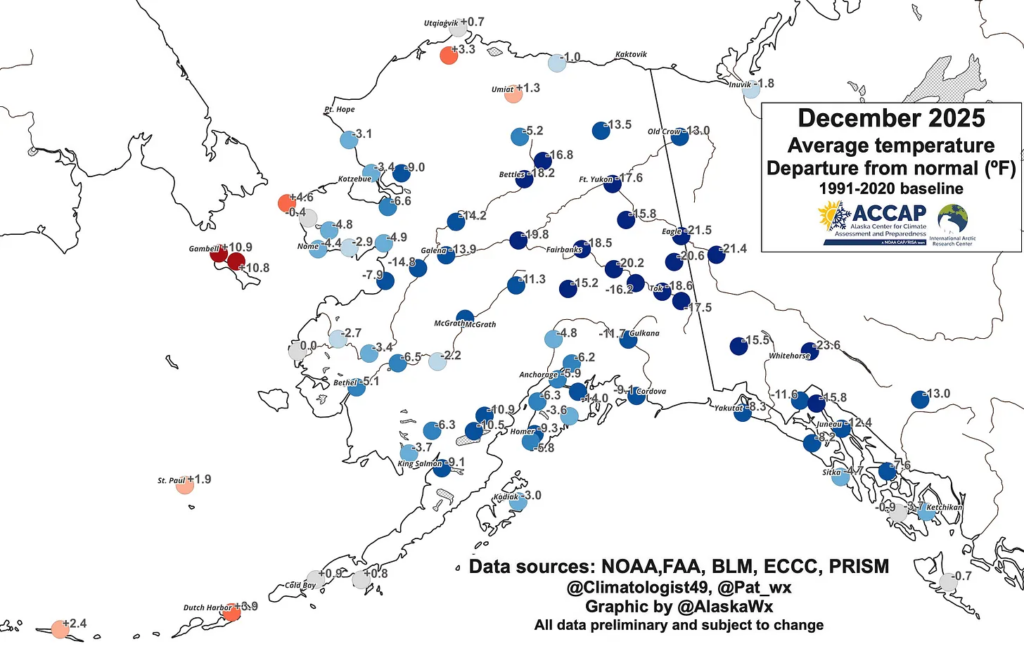
Fig. 2 December 2025 average temperature departures from the 1991-2020 baseline normal. Normals data from NWS and ECCC. Modified 1981-2010 PRISM derived normals courtesy B. Brettschneider.
December 2025 low temperatures
The minimum temperatures reported during the month were low, though a very pronounced west-to-east gradient is obvious (Fig. 3). The eastern Interior and Yukon Territory are areas that historically temperatures reached extremely low levels (the North American record low temperature of -81F was recorded at Snag, YT, near present day Beaver Creek), so it’s unsurprising that mid-winter temperatures in the 50s or even 60s below are not records. Tok’s December low of -58F on the 23rd tied the daily record previous set in 2012, while Northway’s monthly low of -57F on December 22 tied the daily record first set in 1961 and tied in 1971. There were probably a few daily record set in the Yukon, though I don’t have ready access to daily record temperature information.
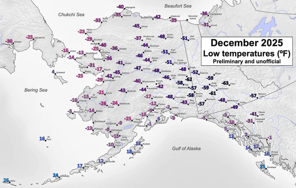
Fig. 3 Lowest temperatures from selected locations during December 2025. Data from NOAA/NWS, FAA, BLM and ECCC.
For reference, all-time December record low temperatures include:
- Fairbanks airport -62F in 1961 & Eagle -69F in 1961
- Tok: -70F in 1964 & Northway: -64F in 1956
- Chicken: -72F in 1999 (observations only since 1996) and Ft. Yukon -71F in 1935
- Dawson: (at least) -66F in 1961 & Whitehorse: (at least) -54F in 1942
The duration of cold is reflected in these December statistics:
- Fairbanks Airport: 12 days with lows in the 40s below (all after Dec 14) and there were 22 hours with dense ice fog (visibility one-quarter mile or lower)
- Tok: 12 days with lows in the 50s below
- Dawson, YT: 19 straight days with lows -40F/C or lower
Here are some “ETs” recorded from around the planet the last couple of days, their consequences, and some extreme temperature outlooks, as well as any extreme precipitation reports:
Here is More Climate News from Monday:
(As usual, this will be a fluid post in which more information gets added during the day as it crosses my radar, crediting all who have put it on-line. Items will be archived on this site for posterity. In most instances click on the pictures of each tweet to see each article. The most noteworthy items will be listed first.)