The main purpose of this ongoing blog will be to track global extreme or record temperatures related to climate change. Any reports I see of ETs will be listed below the main topic of the day. I’ll refer to extreme or record temperatures as ETs (not extraterrestrials).😜
Dear Diary. Here on the Extreme Temperature Diary, we track not only heat waves but cold outbreaks as well. Cold waves in association with freezing rain are the worst, exposing residents to the prospect of freezing if they don’t get heat due to furnaces dying once electricity gets cut off, so they are deadly like this one will be. Due to climate change we are seeing less major winter Arctic outbreaks of frigid air, especially during the 2020s, but the atmosphere remains able to produce a few brutal episodes. One is happening now across the eastern 2/3rds of the U.S.
My rules for naming cold waves can be found here:
The Weather Channel has already designated the major winter storm in association with this cold outbreak as Fern, so that is what we will call it. So far, Fern has not produced that many cold records manly because it is occurring during the climatological coldest week of winter, which is the third week of January but is frigid enough to warrant my major CAT3 designation, thus it also warrants a name designation.
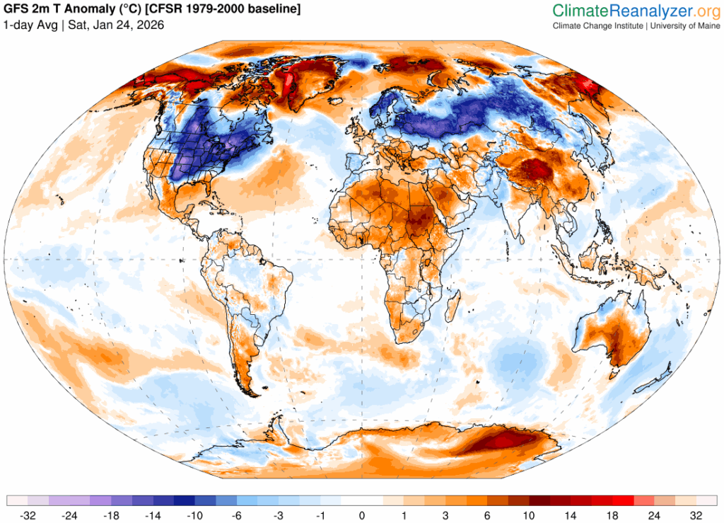
As of this Saturday Fern is the coldest air mass relative to average across the Northern Hemisphere:
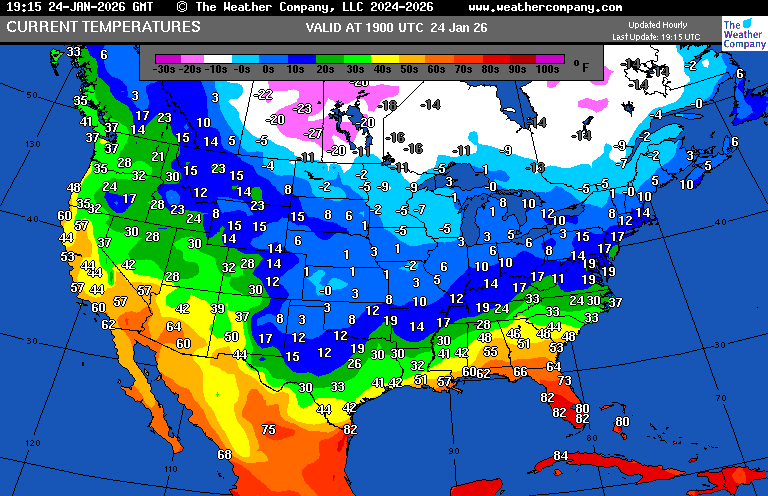
Current temperatures are brutal from Texas into the Midwest this Saturday afternoon:
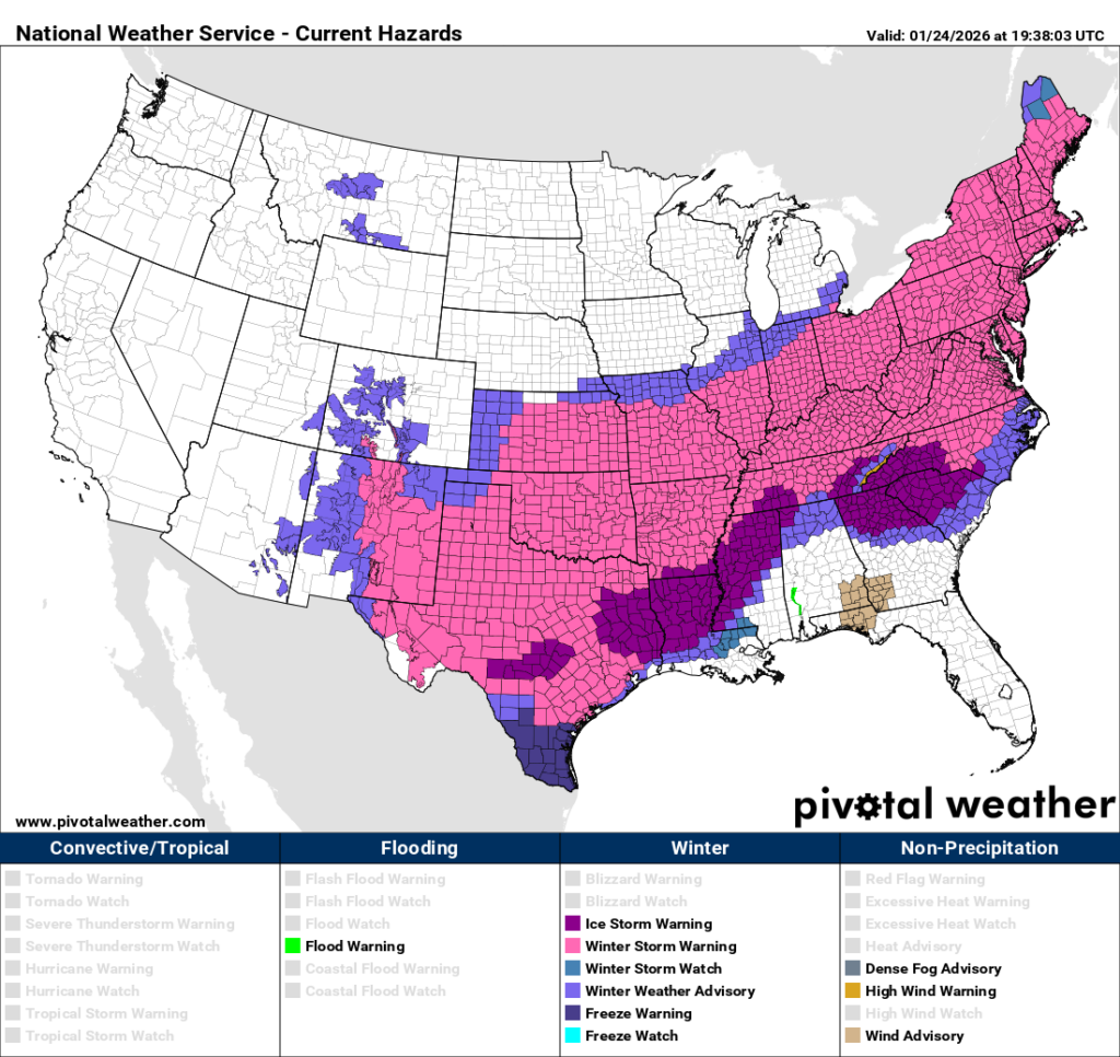
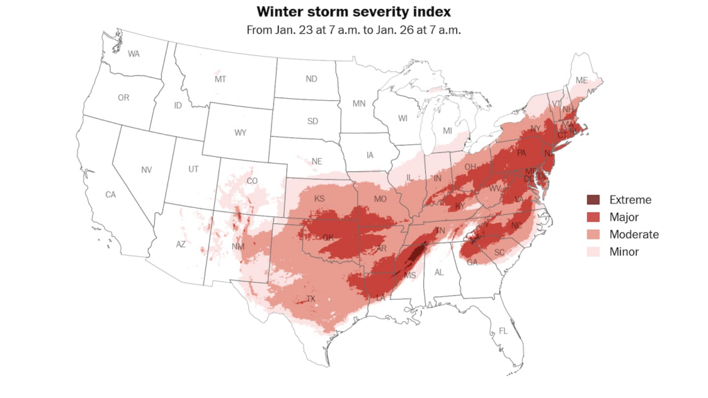
Fern is immense, encompassing an area of winter storm warnings that have rivaled the United State’s biggest winter systems:
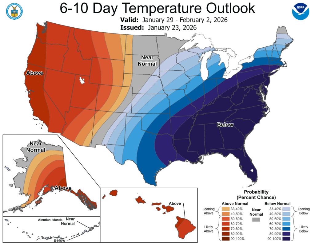
Fern will be reinforced with shots of Arctic air into early February:
Here are some of the latest details on Winter Storm Fern from the Washington Post:
A major winter storm is hitting the U.S. Here are city-by-city forecasts. – The Washington Post
These 12 cities will be hit hardest by the massive winter storm
The United States is bracing for one of its most widespread winter storms in years, which will start Friday.
January 23, 2026
Major winter storm impacts will be widespread from the Plains to New England in the days ahead. (Ben Noll/The Washington Post)

By Ben Noll
The United States is bracing for one of its most widespread winter storms in years, which will start Friday.
Around 205 million people across the country are under winter weather alerts for snow, ice or extreme cold ahead of the forming tempest.
The storm’s journey will take four days as it develops over the Rockies and Plains on Friday and departs the Northeast on Monday night.
Over those four days, a destructive swath of ice will hit dozens of cities in a stretch from northern Texas to southern Virginia, with the likelihood of tree damage and long-lasting power outages. North of there, a corridor of 10 to 20 inches of powdery snow will pile up from Oklahoma to Maine, making some roads impassable and causing significant disruptions to daily life.
In between those zones, there will be a mix of snow, sleet and freezing rain — this area includes D.C. and the Mid-Atlantic, where shoveling will be tougher because of the crusty layer of ice that forms on top of the snow.
And across the Upper Midwest, wind chills Friday will nosedive to minus-40 to minus-55 degrees Fahrenheit — which can cause frostbite in minutes. Around 120 million people across the country are forecast to experience subzero temperatures through Wednesday.
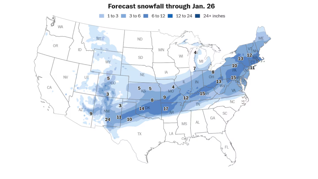
A large swath of more than 10 inches of snowfall is forecast from the Southwest to New England. (Ben Noll/The Washington Post)
City-by-city forecasts
This storm will be noteworthy because of its sheer size, driven by the unusual combination of frigid air from the polar vortex colliding with an atmospheric river.
During its peak Sunday, more than half of the people living in the contiguous United States are forecast to experience snow, sleet or freezing rain simultaneously.
To help people prepare for this massive storm, here’s a detailed forecast for a dozen cities that will be hit hardest. Each forecast starts with a winter storm-impact rating — a subjective assessment of the severity of the conditions expected from the storm, with zero being the least impactful and 10 being the most.
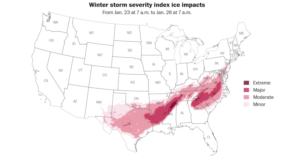
Major-to-extreme impacts from ice, including downed trees, power lines and long-lasting power outages, are expected across portions of the South. (Ben Noll/The Washington Post)
Oklahoma City
Winter storm-impact rating: 9 out of 10.
Worst of the storm: Friday night through Saturday night.
The snow-ice dividing line will stretch across Oklahoma — roughly following the Interstate 40 corridor — with more snow in the northern part of the state and more ice to the south.
This means that Oklahoma City will sit squarely between the two, probably picking up 6 to 10 inches of snow and sleet as well as a glaze of ice — creating dangerous travel conditions.
The combination of frigid temperatures in the teens and single digits, as well as gusty winds, will increase the risk for frostbite and hypothermia. Extreme cold will follow the storm, continuing for much of next week.
Dallas/Fort Worth
Winter storm-impact rating: 9 out of 10.
Worst of the storm: Saturday through early Sunday.
In Dallas, Fort Worth and much of the Interstates 20 and 30 corridors, ice will be a growing problem Saturday.
As frigid air seeps southward across the state, it will allow rain to freeze on contact, leading to increasingly dangerous travel conditions and a rising risk for downed tree branches and power outages into Saturday night and Sunday — especially when combined with gusty winds.
How much precipitation falls as freezing rain versus sleet will determine the severity of the impact — and that will vary by location. It looks like there could be more ice to the south and/or east of Dallas, including Waco and Tyler, Texas as well as Austin.
Even Houston may not be spared from this storm’s impact — freezing rain could reach the city early Sunday, threatening to turn roads and sidewalks into skating rinks. A winter storm watch was in effect there early Friday.
According to the National Oceanic and Atmospheric Administration’s winter storm-severity index, major ice impacts are possible. At the major impact level, widespread closures and disruptions to infrastructure may occur.
“Significant ice accumulation on power lines and tree limbs may cause widespread and long-lasting power outages. Expect power outages and tree damage due to the ice. Travel could be impossible,” wrote the Weather Service in Fort Worth.
After the storm, frigid temperatures in the teens and 20s are expected through Tuesday morning, which could be dangerous in places that lose power.
Little Rock
Winter storm-impact rating: 8 out of 10.
Worst of the storm: Saturday through the first half of Sunday.
This winter storm will have significant impacts across Arkansas, with a sharp dividing line between heavy snow in the northern portion of the state and ice in the south — with a mix of both in the middle, including Little Rock.
Snow will develop there Friday night before mixing with and changing to sleet, whose pinging sounds on the roof will be unmistakable. These small, dense ice pellets don’t accumulate as efficiently as snow and, therefore, will lead to lower combined snow and ice amounts of a few inches.
But don’t let sleet fool you, as roads will be snow- and ice-covered into Sunday, leading to dangerous conditions.
In southeastern Arkansas, an ice storm warning is in place. The situation there looks serious, with long-lasting power outages and tree damage possible.
Tupelo, Mississippi
Winter storm-impact rating: 10 out of 10.
Worst of the storm: Saturday through the first half of Sunday.
An area extending from northern Louisiana, across northern and western Mississippi including Tupelo, to northwestern Alabama is one of the zones of highest concern for crippling amounts of ice.
Across this region, ice accretion may reach one inch. Winds may also reach 15 mph for a time Sunday, adding stress to power lines and tree branches that become heavier as ice coats them.
At those levels, prolonged and widespread utility interruptions and extensive damage are possible, with power outages lasting for days after
“Travel should be restricted to emergencies only. Prepare for extended power outages,” wrote the Weather Service in Memphis.
After the storm passes, freezing temperatures are forecast to linger into Tuesday, creating dangerous conditions for those that lose power.
Nashville
Winter storm-impact rating: 9 out of 10.
Worst of the storm: Saturday afternoon through the first half of Sunday.
The storm will bring a mix of wintry precipitation to Tennessee, including Nashville.
Several inches of snow will fall early Saturday followed by a changeover to sleet and freezing — icing that will create dangerous conditions across much of the state, with moderate to major impacts.
Freezing temperatures, dipping below zero in parts of Tennessee, could be life-threatening to those that lose power for an extended period.
Cincinnati
Winter storm-impact rating: 9 out of 10.
Worst of the storm: Saturday evening through Sunday.
This looks like a heavy snow event for Cincinnati and most of Ohio, and it will really pile up on Sunday, when snow rates could reach an inch per hour.
Frigid temperatures through the lower atmosphere — one that looks primed to produce big, fluffy flakes — should make this storm a big one across Ohio.
By the time the storm ends Sunday night, widespread snowfall of 10 to 15 inches is expected.
Frigid temperatures will linger for much of next week, as will massive snow piles.
Pittsburgh
Winter storm-impact rating: 9 out of 10.
Worst of the storm: Saturday night through Sunday evening.
This storm looks like a whopper for western Pennsylvania, where widespread accumulations of 10 to 15 inches are expected.
Snow rates could reach an inch per hour Sunday afternoon, with windswept snow creating disorienting conditions at times.
There’s no warmup in sight, with temperatures falling well below zero on Tuesday.

A whopper winter storm crosses the United States in the days ahead. (Ben Noll/The Washington Post; Data source: ECMWF)
Charlotte
Winter storm-impact rating: 9 out of 10.
Worst of the storm: Saturday evening through Sunday night.
Central North Carolina, including Charlotte, Raleigh and Durham, is bracing for a major ice event from late Saturday through Sunday. The ice may even be more severe closer to the Appalachians, including Asheville in North Carolina, Greenville in South Carolina and Athens in Georgia.
There is uncertainty as to how much sleet versus freezing rain will fall, but there is the potential for widespread and long-lasting power outages in the region. That’s in addition to roads and sidewalks that will turn into skating rinks, which will last through Sunday night.
Occasional wind speeds of up to 15 mph will cause added stress to power lines and trees that are cased in ice.
Richmond
Winter storm-impact rating: 9 out of 10.
Worst of the storm: Saturday night through Sunday night.
Wintry weather will wallop Richmond and most of Virginia starting Saturday night. Following a snow accumulation of 3 to 6 inches, sleet and freezing rain will move in, bringing significant icing to Richmond and points west.
Because of this, there is an increasing chance for power outages, especially across the southern half of Virginia, including the area from Richmond to Lynchburg and Roanoke and points south.
Wider D.C. area
Winter storm-impact rating: 9 out of 10.
Worst of the storm: Late Saturday night through Sunday night.
The tempest will blast the nation’s capital with heavy snow, sleet and some freezing rain, starting late Saturday evening.
Snow accumulation will be fast and furious early Sunday, when snow rates could reach over an inch per hour. Amounts of 6 to 10 inches are expected in the District, although locally higher amounts are possible, especially north of town.
Snowfall would be even more significant if not for a changeover to sleet, which is expected to occur Sunday morning. That will leave behind a crusty layer of ice that makes shoveling harder. Late Sunday, sleet may change to freezing rain, casing mounds of snow and sleet in ice.
There is a chance for tree damage and power outages, especially south of D.C. where icing will be worse.
Although the storm will end by Monday morning, roads and sidewalks will remain treacherous, as temperatures may not rise above freezing for the rest of the month.
New York
Winter storm-impact rating: 8 out of 10.
Worst of the storm: Sunday through early Monday.
Similar to D.C., New York will have a period of heavy snow with rapid accumulation before a changeover to ice.
From late Sunday morning into the afternoon, snow rates could eclipse an inch per hour, turning the Big Apple into a winter wonderland. Snowfall of 8 to 12 inches is expected before a change to sleet Sunday evening, which could ping off roofs and windows through the night. Snow may return Monday morning, falling lightly throughout the day.
To the north of the city, parts of the Hudson Valley could receive 10 to 20 inches of snow, with localized totals of up to two feet.
There will be significant travel disruptions and flight cancellations across the region. Temperatures may not rise above freezing for a week or more, with untreated sidewalks remaining slippery for pedestrians.
Boston
Winter storm-impact rating: 9 out of 10.
Worst of the storm: Sunday afternoon into Monday.
This storm is going to be a big one in Boston, with deep snow cover making some roads impassable Sunday night during the storm’s peak.
Snow will be light and fluffy, easily piling up to 12 to 18 inches by Monday morning, with locally higher amounts possible, especially west of town.
School closures are likely Monday as the city digs out.
Snow piles will be massive and last for weeks, with frigid conditions hovering near the East Coast into February.
Much More:
Here are some “ETs” recorded from around the planet the last couple of days, their consequences, and some extreme temperature outlooks, as well as any extreme precipitation reports:
Here is More Climate News from Saturday:
(As usual, this will be a fluid post in which more information gets added during the day as it crosses my radar, crediting all who have put it on-line. Items will be archived on this site for posterity. In most instances click on the pictures of each tweet to see each article. The most noteworthy items will be listed first.)