The main purpose of this ongoing blog will be to track planetary extreme, or record temperatures related to climate change. Any reports I see of ETs will be listed below the main topic of the day. I’ll refer to extreme or record temperatures as ETs (not extraterrestrials).😉
Main Topic: Heatwave Shell Is About to Bring Extreme Heat and Humidity to More Than 200 Million
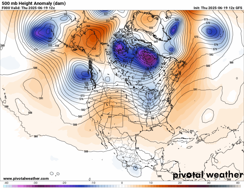
Dear Diary. We might have a strong case cooking (pub intended) for another climate crisis event this summer. Over the weekend meteorological models for locked into forecasting a very strong heat done that would be centered over the eastern United States:
As of today we are already beginning to see excessive heat watches forecast for the Upper Midwest.
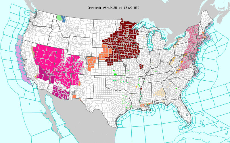
Heat warnings remain in place for portions of the Southwest in association with Heatwave Occidental. Its heat is being funneled northeastward in association with a new heat dome now centered over west Texas and New Mexico.
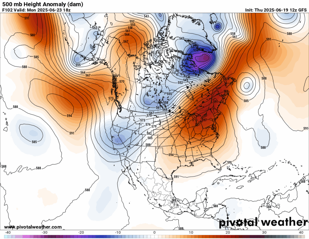
That ridge will rapidly grow to a 597+ decameter monster by Sunday centered over the mid-Atlantic area:
By this point all media outlets that report on weather are focused on what I’ve dubbed Heatwave Schell. Here is one of the best writeups with the latest details from the Washington Post:
https://www.washingtonpost.com/weather/2025/06/19/maps-extreme-heat-humidity-forecast
A heat dome is about to bring extreme heat and humidity to more than 200 million
Maps show where extreme humidity and 90- or 100-degree temperatures will affect around 255 million people across the United States.
June 19, 2025

Wyatt Seymore pours the last drops of liquid from a water bottle into his mouth as he takes a break in Weldon Spring, Missouri. (Jeff Roberson/AP)

By Ben Noll
The first heat wave of summer, starting Friday in central states, will bring days of extreme conditions to many cities across the United States, with humidity levels reaching far beyond what is normal for this time of year.
A heat dome — a heat-trapping lid of strong high pressure in the atmosphere — will expand eastward after forming Friday and intensify through next week. For a week or longer, it’s expected to lead to hundreds of record-breaking temperatures, tropical levels of humidity and abundant sunshine — a combination that can be dangerous, elevating the risk for heat stress and making it challenging for people to cool off.
Temperatures are forecast to exceed 90 degrees for around 220 million people across the country. Temperatures may reach or exceed 100 degrees for an additional 35 million people next week, including those living in the Northeast and Mid-Atlantic.
Unusually high humidity and temperatures will cause widespread, dangerous heat indexes. As of early Thursday, extreme heat watches, warnings and advisories cover the Southwest, Rockies, Plains, Upper Midwest and parts of the Northeast — these alerts will probably expand in the days ahead.
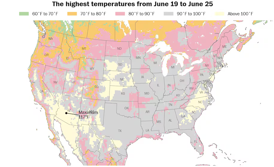
Maximum temperatures in excess of 90 or 100 degrees are forecast for around 255 million people across the country over the next week. (Ben Noll/Data source: ECMWF)
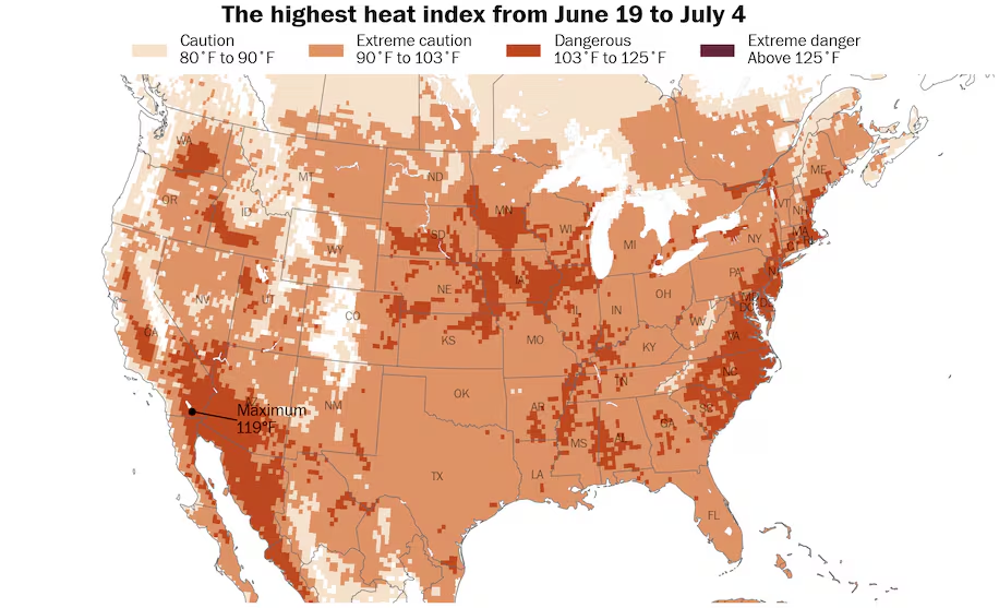
Dangerous heat indexes are forecast for dozens of states, including the Plains, Midwest, Mid-South and East Coast over the next week. (Ben Noll/Data source: ECMWF)
Where the hottest conditions will be
Thursday will be a hot and humid day along the Eastern Seaboard with a risk for strong-to-severe evening thunderstorms from New York to Washington.
But that spell of heat will be relatively minor compared to what the heat dome will bring over the next week to 10 days.
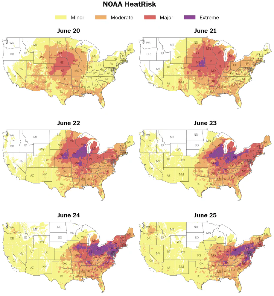
There’s a Level 4 out of 4 extreme risk for heat-related impacts across central and/or eastern states from Saturday to Wednesday. (Ben Noll/Data source: NOAA)
Here’s a day-by-day overview of the heat wave from Friday to Wednesday, according to National Oceanic and Atmospheric Administration’s HeatRisk tool, which provides forecast risk of heat-related impacts based on temperatures and humidity.
Friday
Highest heat locations: Eastern Rockies, Plains and Upper Midwest.
High heat and humidity will intersect over the Plains, with a Level 3 out of 4 major risk for heat-related impacts covering areas from eastern Colorado to southern Minnesota.
Temperature records may tumble in Denver, where it’s forecast to reach 100 degrees, as well as in Nebraska, South Dakota and Iowa.
Extreme humidity will stretch from the Gulf Coast to western Minnesota.
Saturday
Highest heat locations: Eastern Rockies, Plains, Midwest and Mid-South.
Hot and humid conditions will expand eastward into the Midwest on Saturday, with widespread major risks for heat-related impacts from Oklahoma and Arkansas to Minnesota, Wisconsin and Michigan.
Denver (99 degrees) and Minneapolis (95 degrees) may tie or break temperature records.
Extreme humidity will expand northward into the Great Lakes, affecting St. Louis, Chicago, Milwaukee and Indianapolis.
Sunday
Highest heat locations: Plains, Midwest, Ohio Valley, Mid-South, Northeast and Mid-Atlantic.
The hot weather will expand to the East Coast while intensifying across the Midwest, where the risk for heat-related impacts is forecast to reach the highest level on NOAA’s scale.
The most oppressive heat and humidity will likely be found in a corridor that extends from Nebraska to Michigan. Highs will generally be in the mid-90s to near 100 and, coupled with extreme levels of humidity, will make it challenging for people to cool down without air conditioning.
There will be little relief at night. Dozens of high overnight temperature records are forecast in the Plains and the Midwest, where temperatures will only fall into the mid-70s to near 80.
High temperatures in the Mid-Atlantic and Southeast will be in the mid- to upper-90s, including Baltimore, Washington, Norfolk and Charlotte.
Parts of Ontario, Canada will also reach the 90s.
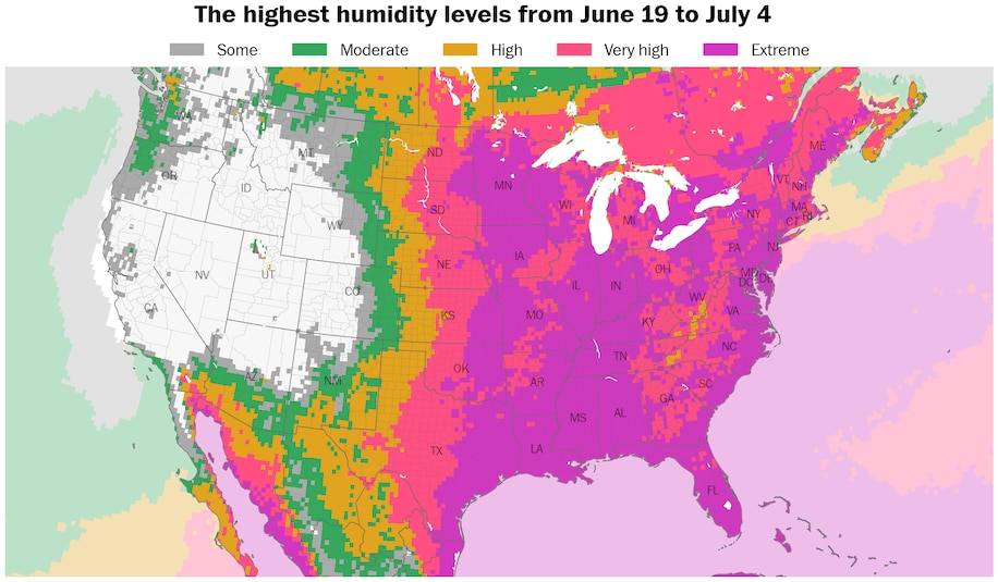
Extreme humidity levels are forecast for around 40 states as well as southern Canada. (Ben Noll/Data source: ECMWF)
Monday
Highest heat locations: Midwest, Ohio Valley, Mid-South, Northeast, Mid-Atlantic and Southeast.
Extreme humidity and heat will intensify in the East while reaching a peak in the Midwest.
Record-warm morning temperatures are expected from the Midwest to the Northeast and Mid-Atlantic, followed by record-breaking daytime temperatures in the Ohio Valley, Northeast and Mid-Atlantic.
High temperatures may near 100 in areas from New York to Washington, and southward to Charlotte.
Extreme heat and humidity will also stretch from Toronto to Ottawa and Montreal — and surrounding provincial areas in Canada.
Tuesday
Highest heat locations: Midwest, Ohio Valley, Mid-South, Northeast, Mid-Atlantic and Southeast.
Record-breaking heat is forecast to continue in parts of the Midwest, Ohio Valley, Northeast, Mid-Atlantic and Carolinas.
The highest temperatures will stretch from Massachusetts to Georgia, where the areas around major cities such as Boston, New York, Philadelphia, Baltimore and Washington could face triple-digit heat. Part of this zone is in a Level 4 out of 4 extreme risk for heat-related impacts on NOAA’s scale.
Wednesday
Highest heat locations: Ohio Valley, Mid-South, Northeast, Mid-Atlantic and Southeast.
The heat dome will remain anchored over the Mid-Atlantic, with extreme heat and humidity continuing near the Eastern Seaboard.
Temperatures could again reach or exceed 100 degrees in areas from New York to Atlanta.
How long it will last
The heat dome is forecast to linger near the Mid-Atlantic through the end of next week.

A heat dome will form and expand over central and eastern states during the next week. (Ben Noll/Data source: ECMWF)
Once it fades, it’s not expected to get significantly cooler. Weather models are suggesting that above-average heat and humidity will redevelop in early July — in western states first, then pushing eastward.
Around the western and northern edge of the heat dome, heavy rain and thunderstorms may cause a flood risk from New Mexico to Minnesota and Wisconsin, eastward to New England next week — fueled by moisture from a major hurricane near Mexico.
Heat waves in Europe, Middle East and Asia
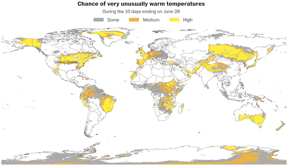
Heat waves are forecast across the United States and Canada, Europe, Africa, the Middle East and Asia over the next 10 days. (Ben Noll/Data source: ECMWF)
Across the planet, around 1.3 billion people have at least a medium chance of being affected by very unusually warm temperatures over the next 10 days.
This includes well-above-average temperatures in the United States and southern Canada, the Caribbean, western and Central Europe, parts of Africa and the Middle East and large parts of Asia.
Summer is predicted to be warmer than average for much of the Northern Hemisphere — including areas where heat waves will hit in the weeks ahead.
By Ben Noll Ben Noll is a meteorologist passionate about explaining the why behind the weather, extreme events and climate trends. He has expertise in data analysis, supercomputer-driven graphics and forecasting weather worldwide. follow on X@BenNollWeather
Here are more “ET’s” recorded from around the planet the last couple of days, their consequences, and some extreme temperature outlooks, as well as any extreme precipitation reports:
Here is More Climate News from Thursday:
(As usual, this will be a fluid post in which more information gets added during the day as it crosses my radar, crediting all who have put it on-line. Items will be archived on this site for posterity. In most instances click on the pictures of each tweet to see each article. The most noteworthy items will be listed first.)