The main purpose of this ongoing blog will be to track global extreme or record temperatures related to climate change. Any reports I see of ETs will be listed below the main topic of the day. I’ll refer to extreme or record temperatures as ETs (not extraterrestrials).😜
Main Topic: Climate Change Effects on Nor’easter Hernando
Dear Diary. Northeastern U.S. coastal cities are bracing for the worst snowstorm in years. Even at +1.3°C above preindustrial conditions for global temperature averages big traditionally located winter storms are still possible, but they are becoming rarer. Before this season New York City had been in a snow drought for a couple of years, for example.
So what might climate change do to make the Weather Channel’s designated Nor’easter Hernando worse? Warmer ocean water temperatures than average will aid in deepening the low-pressure system in association with Hernando plus add more moisture to the atmosphere for the storm to work with.
We have delved into nor’easters and climate change before:
Here are more details on Hernando from the Washington Post:
Blizzard will blast the Mid-Atlantic, Northeast starting Sunday – The Washington Post
Blizzard will blast the Mid-Atlantic and Northeast starting Sunday night
A forming nor’easter will rapidly intensify off the Mid-Atlantic coast from Sunday night into Monday, with about 30 million people covered by blizzard warnings.
Updated February 22, 2026 at 12:50 PM
A nor’easter will bring blizzard conditions to the Mid-Atlantic and Northeast from Sunday through Monday. (Video: Ben Noll; NOAA/TWP)
A forming nor’easter will rapidly intensify off the Mid-Atlantic coast from Sunday night into Monday, with about 30 million people covered by blizzard warnings — from coastal Virginia to southern New Hampshire.
The worst of the storm will be felt from Sunday night through Monday, when more than a foot of snow is forecast in a corridor from Delaware to southeast Massachusetts. In New York and New Jersey, states of emergency have already been declared.
Up to 2 feet of snow could fall in the hardest-hit areas of southern New England, with snow drifts reaching 3 to 5 feet. Meteorologist Eric Fisher, based in Boston, called it the “signature storm of this season” in a post on X.
Saying parts of New York City could see up to 28 inches of snow, Mayor Zohran Mamdani (D) announced Sunday a citywide travel ban on streets, highways and bridges starting at 9 p.m. The ban will remain in place until noon Monday. Mamdani also announced that New York City Public Schools will be closed Monday without remote learning, the first such closure since 2019.
“If it comes to pass as predicted, this will put the snowfall in the top 10 snowfall events in the history of New York City,” Mamdani said. “That is what we are looking at. So the reason we have enacted a travel ban is to keep New Yorkers safe.”
But Mamdani stressed police would make exceptions for essential and emergency workers. Travel conditions will rapidly deteriorate and turn dangerous later Sunday as snow turns heavier and winds begin to howl, creating whiteout conditions.
“Travel should be restricted to emergencies only. If you must travel, have a winter survival kit with you. If you get stranded, stay with your vehicle,” wrote the National Weather Service in Upton, New York.
About 42 million people can expect major or extreme winter weather impacts in the Mid-Atlantic and Northeast.
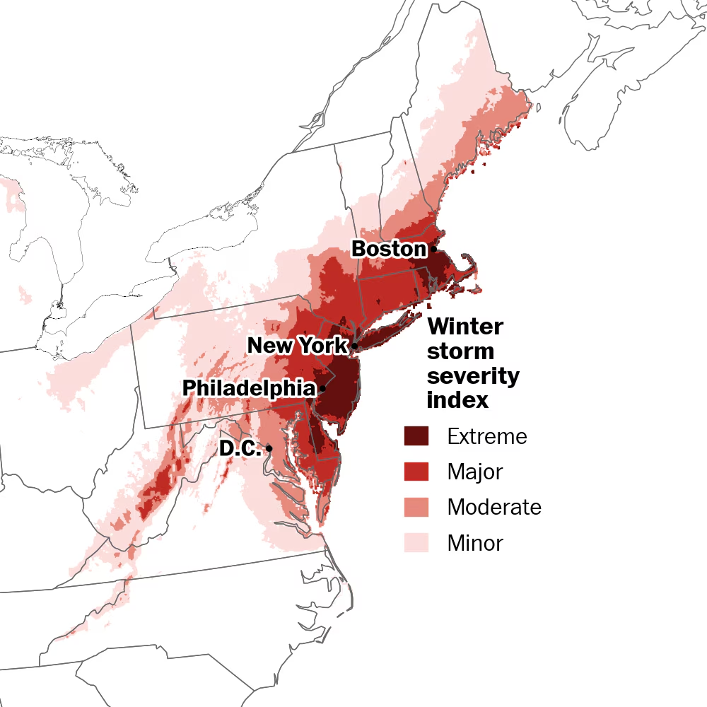
Around 42 million people across the Mid-Atlantic and Northeast can expect major or extreme winter storm impacts. (Ben Noll/The Washington Post; data source: NOAA)
The latest on the storm
The storm was just a weak wave of low pressure over North Carolina early Sunday, but by early Monday, it will become a bomb cyclone south of Cape Cod, Massachusetts.
Here’s a breakdown of key forecast details.
Timeline
Light snow will gradually expand across the Northeast and Mid-Atlantic on Sunday, but accumulation will be limited into the afternoon by above-freezing temperatures.
Later in the afternoon and evening, as the storm starts to intensify, bands of steady to heavy snow will hit a stretch from the eastern Mid-Atlantic to southern New England.
That will coincide with worsening conditions in cities such as Baltimore, Philadelphia and New York, especially around nightfall. Meanwhile, while light to moderate snow will fall in D.C., the city is expected to avoid the worst of the storm.
By Monday morning, these snow bands will be spiraling hundreds of miles from the storm’s offshore center — from Maryland to Massachusetts — as tropical-storm-force winds, gusting 50 to 70 mph, blast the coast.
The storm will depart northern New England by Tuesday morning.
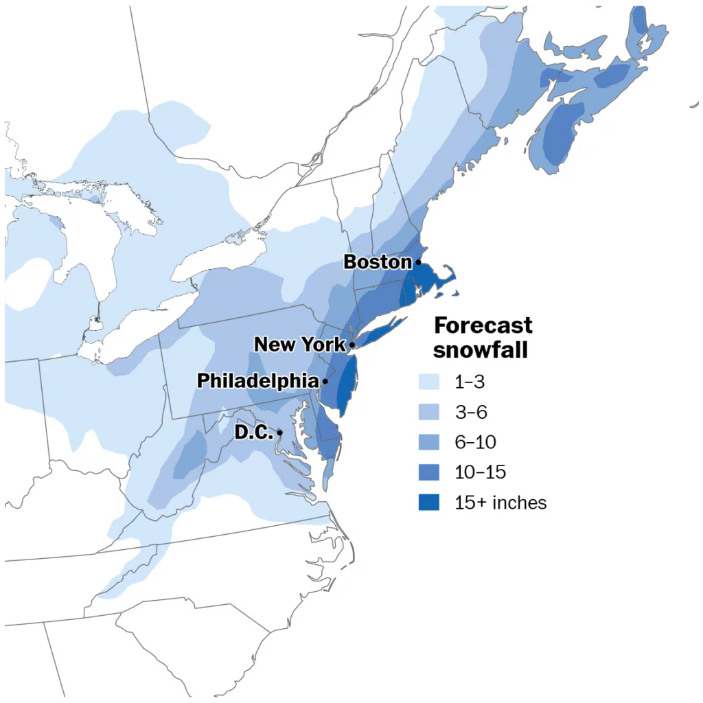
How much snow will fall?
A lot of people will get a lot of snow from this storm.
It looks as though the snowiest spots will be found across Delaware, New Jersey, New York and Long Island, southern and eastern Connecticut, Rhode Island, and eastern Massachusetts.
Blizzard conditions are expected from coastal Virginia to southern New Hampshire from Sunday through Monday. (Ben Noll/The Washington Post; data source: ECMWF/AIFS)
That’s where more than a foot of snow is most likely, with localized totals pushing toward 2 feet — including in Dover, Delaware; Atlantic City; Islip, New York; New London, Connecticut; Providence, Rhode Island; and Boston.
Just outside this zone of heaviest snow, a swath of 10 to 15 inches will be found, probably including Philadelphia, New York, Newark and Hartford, Connecticut.
“The snow is back. But New York is ready,” Mamdani wrote in a post on X. He said that the city activated more than 2,200 emergency snow shovelers and that a decision on the status of remote learning on Monday will be made by noon Sunday.
Meanwhile, in D.C., The Washington Post’s Capital Weather Gang expects 1 to 4 inches of snow accumulation, mostly occurring Sunday evening into early Monday, probably leading to school disruptions.
Storm impacts
In areas covered by blizzard warnings, the combination of heavy snow and wind will cause visibility to drop below a quarter of a mile during the peak of the storm.
“The strong winds and weight of snow on tree limbs may down power lines and could cause sporadic power outages,” wrote the Weather Service in Upton, New York.
Winds will remain gusty across the region into Tuesday, so blowing snow will persist even after the storm passes, which may cause cleared roads and sidewalks to become covered once again.
Weather Service offices from Delaware to New York also warned of moderate to major coastal flooding as strong winds push water inland, exacerbated by higher astronomical tides and the inverted barometer effect — which occurs when air rises inside strong storms, lowering the air pressure and allowing the ocean surface to rise.
“At this level, flooding may become severe enough to cause structural damage along with widespread roadway flooding in coastal and bayside communities, and near inland tidal waterways,” wrote the Weather Service in Mount Holly, New Jersey.
After the nor’easter, more storms could hit the Northeast this week.

By Ben Noll Ben Noll is a meteorologist passionate about explaining the why behind the weather, extreme events and climate trends. He has expertise in data analysis, supercomputer-driven graphics and forecasting weather worldwide. follow on X@BenNollWeather

By Tim Craig Tim Craig is a national reporter on the America desk. He previously served as head of The Washington Post’s Afghanistan-Pakistan bureau, based in Islamabad and Kabul. He has also reported from Iraq, the District and Baltimore. follow on X@timcraigpost
Here are some “ETs” recorded from around the U.S. the last couple of days, their consequences, and some extreme temperature outlooks, as well as any extreme precipitation reports:
Here is More Climate News from Sunday:
(As usual, this will be a fluid post in which more information gets added during the day as it crosses my radar, crediting all who have put it on-line. Items will be archived on this site for posterity. In most instances click on the pictures of each tweet to see each article. The most noteworthy items will be listed first.)