The main purpose of this ongoing blog will be to track planetary extreme, or record temperatures related to climate change. Any reports I see of ETs will be listed below the main topic of the day. I’ll refer to extreme or record temperatures as ETs (not extraterrestrials).😉
Main Topic: Bombs Away…A Nor’easter May Set Records This Weekend
Dear Diary. It’s about time. Folks in the Northeast have waited until late January this winter season to see a strong winter storm from a coastal area of low pressure known as a nor’easter. Typically, we would see several of these before this point in time during the North American winter. The last very strong system to affect the eastern seaboard area actually occurred well before winter in late October:
As a reminder, just what is a “bomb cyclone?” A study in 1980 defined a weather bomb (also sometimes called bombogenesis) as when a storm’s pressure drops 24 millibars in 24 hours.
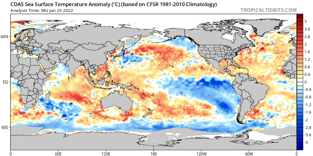
Cold core bomb cyclones are naturally influenced by ocean sea surface temperatures. The warmer the SST’s, the stronger the potential bomb cyclone. This effect was noted by Dr. Michael Mann in my October article. Indeed, we have warmer than average SST’s off of the Northeast Coast at the moment, which are a climate change signature:
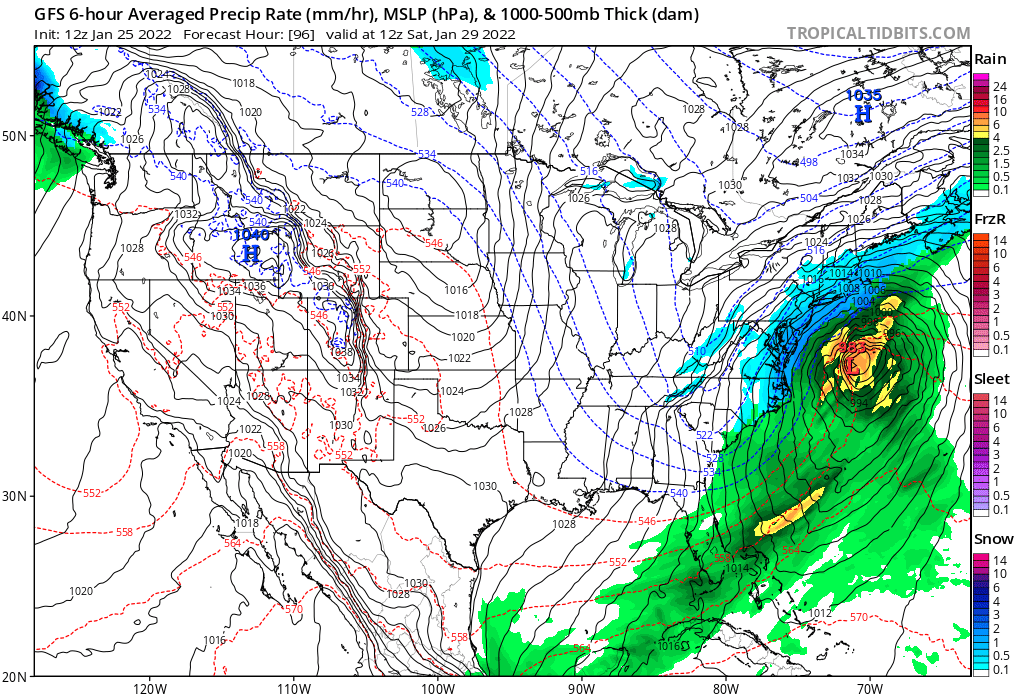
Here is the latest GFS forecast, which wasn’t had a great track record with this system, for Saturday. Sorry Atlanta, you won’t see a winter storm out of this one, as previously forecast a few days ago:
The European model is even more bullish with snow totals than the GFS:
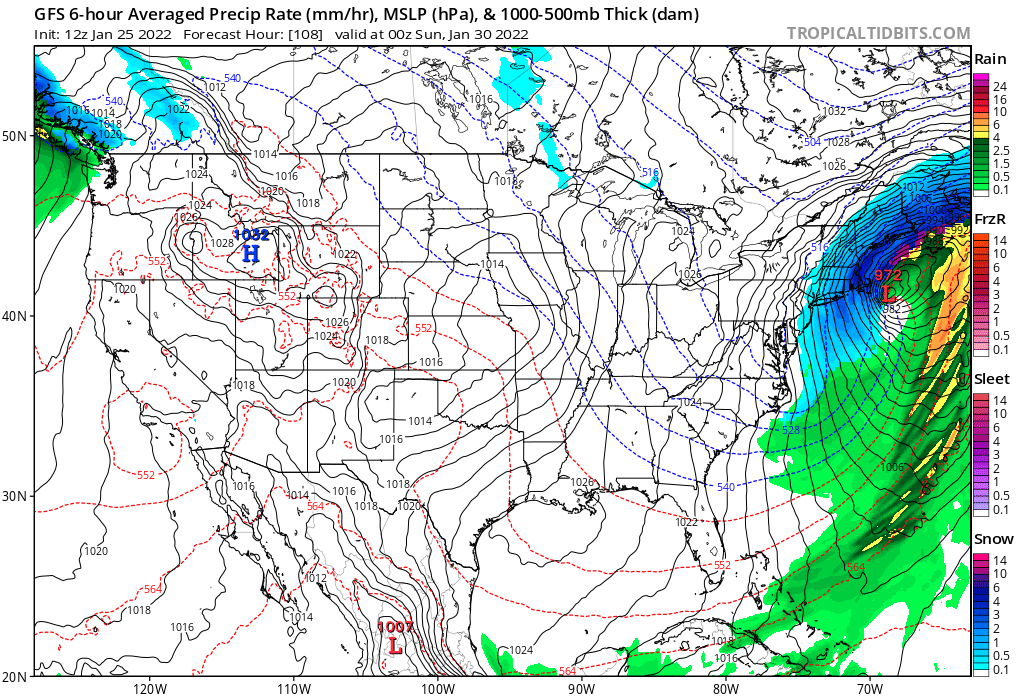
This nor’easter looks like a record breaker, especially when one considers how fast the system may deepen:
Back in October my friend Matthew Capucci wrote a summary of the nor’easters that occurred, which are linked to the post I referred to today. Here is his summary for the coming system that will, affect millions over this weekend:
https://www.washingtonpost.com/weather/2022/01/25/northeast-snowstorm-noreaster-blizzard/
Nor’easter could wallop New England with heavy snow and wind Saturday
Odds are increasing that a foot of snow could fall near the coastline with possible blizzard conditions

American (GFS) model shows storm developing well offshore the Mid-Atlantic on Saturday morning with snow along the coast from the Delmarva to New England. (PivotalWeather)
By Matthew Cappucci and Jason Samenow 1/25/2022 at 12:12 p.m. EST
New England is bracing for what could be a major winter storm on Saturday, with heavy snow, strong winds, blizzard conditions and coastal flooding all within the realm of possibilities. The Mid-Atlantic could be dealt a dose of light snowfall, too, though computer weather models are concentrating their ire farther northeast.
It’s worth emphasizing that, at four days out from the incipient storm, a lot can change — but the stakes are high enough that it’s worth raising awareness for a potentially high-impact system. The zone from eastern Long Island to eastern Maine, including Providence and Boston, is particularly at risk.
A “significant winter storm is possible Friday night and Saturday,” wrote the National Weather Service in Boston on Tuesday morning in an online forecast discussion, but cautioned against taking early predictions as set in stone. “For now, what you can do is prepare for the potential of an impactful snowfall with accompanying strong winds.”
Wild storm in Greece brings thundersnow to Athens, ‘snownado’ to Greek island
Astronomical tides also will be high Saturday, making coastal flooding a greater concern even if the rapidly developing system shifts out to sea.

National Weather Service key messages for Jan. 28-30 winter storm. (NWS)
Computer model forecasts have generally nudged the storm track eastward, compared with Monday, somewhat reducing the chance of heavy snow outside eastern New England but it will take another day or two for greater confidence in the exact track.
A more offshore track increases the likelihood that coastal locations in eastern New England see mostly snow rather than a switch to rain or sleet while reducing potential snowfall farther west into western Massachusetts, Vermont and New Hampshire.
Tracking the ingredients
More than 72 hours remain before the storm begins to take shape off the Southeast and Mid-Atlantic coast, but the ingredients are already beginning to materialize on weather maps.
Two atmospheric disturbances are soon to move ashore over extreme northwestern North America. The first was approaching the Seward Peninsula near Nome, Alaska, and the second had just slipped east of the Aleutians.

The American GFS model depicts “phasing” of multiple mid-level disturbances, which will help generate a surface system. (WeatherBell) (WeatherBell)
The former will scoot southeast over central Canada while the other will dive farther south and pass over the Four Corners region Thursday. The development of a major storm is predicated on both systems overlapping over the Appalachians early Saturday. That will help intensify a storm developing off the Mid-Atlantic coast.
Meanwhile, high pressure will build over eastern Canada into Thursday and Friday, feeding the cold air instrumental for snow into the Northeast.

European modeling system simulation of the storm developing off the Mid-Atlantic coast Friday and roaring northward Saturday. (WeatherBell)
There are signs that the storm will become a “bomb cyclone,” or a storm that rapidly strengthens as it charges up the Northeast coast, triggering a dramatic drop in air pressure. Abnormally warm water in the Gulf of Maine could help energize the storm and increase its intensity.
Gulf of Maine waters spiked to record warm levels in fall 2021
An early look at the forecast
It’s too early for the Weather Service to hoist winter storm watches or warnings, and forecasts offering specific numbers for snow totals are impossible in this time frame. That said, we can paint an early picture of what to expect based on the simulated odds of heavy snow from large numbers of computer model projections.

The European modeling system, compared with the American, projects a storm track closer to the East Coast and generally more snowfall. (WeatherBell)
Washington and Baltimore:
Light snow may break out Friday afternoon. It could briefly become moderate, especially along and east of Interstate 95 on Friday evening. The storm will possibly develop too far offshore for significant accumulations of more than an inch or two; areas over the Delmarva Peninsula have the potential for more.
In the event that the merging of the two parent weather disturbance occurs earlier than currently anticipated, more substantial snow would be possible.
Chance of at least one inch: 40 percent | Chance of at least three inches: 20 percent | Chance of at least six inches: 10 percent
Philadelphia
Philadelphia, being farther northeast, could see a bit more snow than Baltimore and Washington, but still may be too far west to see much before the system rapidly gains strength south of New England. Some light snow is possible Friday evening, potentially coinciding with the evening commute. If the storm develops quickly, snow could continue Friday night with a few inches of accumulation.
Chance of at least one inch: 50 percent | Chance of at least three inches: 30 percent | Chance of at least six inches: 15 percent
New York City
The Big Apple could be close to the zone where substantial snow starts and stops. The odds will increase just to its north and northeast but a blitz of heavy snow and strong winds, gusting over 40 mph, cannot be ruled out. If heavy snow develops, it would be during the day Saturday; lighter snow will probably develop Friday night.
Chance of at least one inch: 60 percent | Chance of at least three inches: 35 percent | Chance of at least six inches: 25 percent
Providence, Boston and Portland, Maine

The American (GFS) model simulates very heavy snow over Rhode Island and eastern Massachusetts on Saturday afternoon and evening. The snow mixes with or changes to sleet over Cape Cod in this simulation. (WeatherBell)
The greatest propensity for a higher-end winter storm will exist along the Interstate 95 corridor from Rhode Island through Boston and coastal New Hampshire and Maine. Patchy light snow may begin late Friday night expanding from south to north, and may become moderate to heavy by sunrise Saturday.
Significant accumulations of at least 6 to 12 inches are possible before the storm pulls away Saturday night. Blizzard conditions, with accompanying winds over 50 mph, could develop if the storm isn’t too far offshore.
Chance of at least one inch: 80 percent | Chance of at least three inches: 65 percent | Chance of at least six inches: 55 percent | Chance of at least 12 inches: 25 percent
Interior New England
While it will certainly be cold enough for snow, whether any precipitation ultimately falls hinges on the track of the system. Locations from western Connecticut through the Berkshires, Vermont, New Hampshire and far western areas of Maine may just get brushed with light snow if the storm tracks far offshore but could see more substantial amounts if it comes closer to the coast. (The probabilities shown below are highest in eastern areas and lowest in western areas of interior New England.)
Chance of at least one inch: 45 to 75 percent | Chance of at least three inches: 35-60 percent | Chance of at least six inches: 25-50 percent8 CommentsGift Article

By Matthew Cappucci is a meteorologist for Capital Weather Gang. He earned a B.A. in atmospheric sciences from Harvard University in 2019, and has contributed to The Washington Post since he was 18. He is an avid storm chaser and adventurer, and covers all types of weather, climate science, and astronomy. Twitter

By Jason Samenow is The Washington Post’s weather editor and Capital Weather Gang’s chief meteorologist. He earned a master’s degree in atmospheric science and spent 10 years as a climate change science analyst for the U.S. government. He holds the Digital Seal of Approval from the National Weather Association. Twitter
Here are some “ET’s” from Tuesday:
Here is more climate and weather news from Tuesday:
(As usual, this will be a fluid post in which more information gets added during the day as it crosses my radar, crediting all who have put it on-line. Items will be archived on this site for posterity. In most instances click on the pictures of each tweet to see each article. The most noteworthy items will be listed first.)
Now here are some of today’s articles and notes on the horrid COVID-19 pandemic:
(If you like these posts and my work please contribute via the PayPal widget, which has recently been added to this site. Thanks in advance for any support.)
Guy Walton “The Climate Guy”