The main purpose of this ongoing blog will be to track planetary extreme, or record temperatures related to climate change. Any reports I see of ETs will be listed below the main topic of the day. I’ll refer to extreme or record temperatures as ETs (not extraterrestrials).😜
Main Topic: Blizzard Iona Made Worse by Our Burning of Fossil Fuels
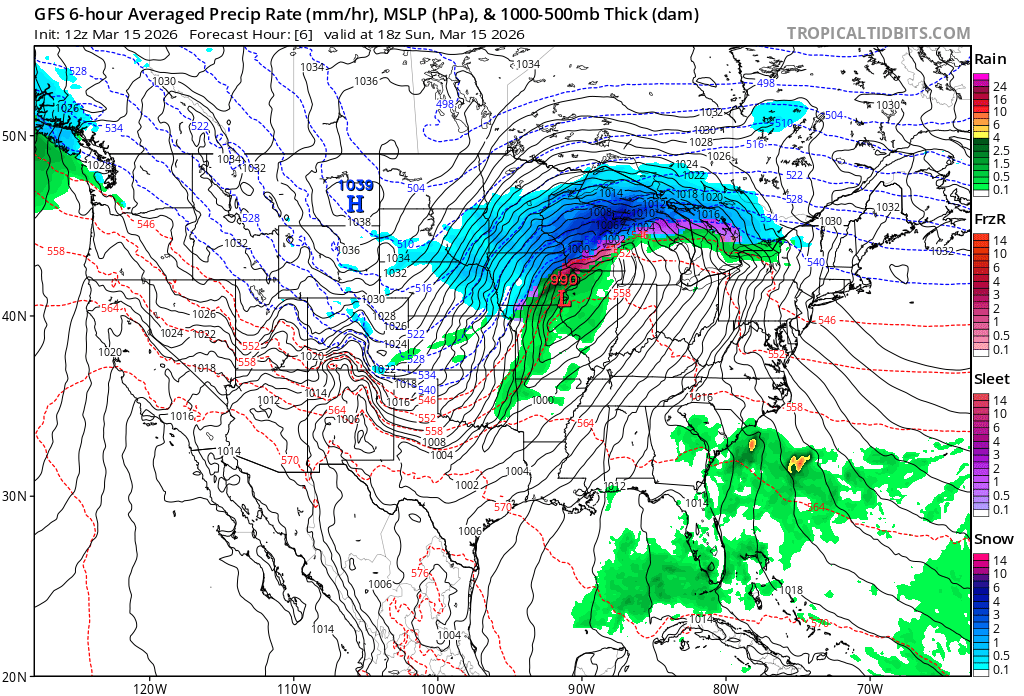
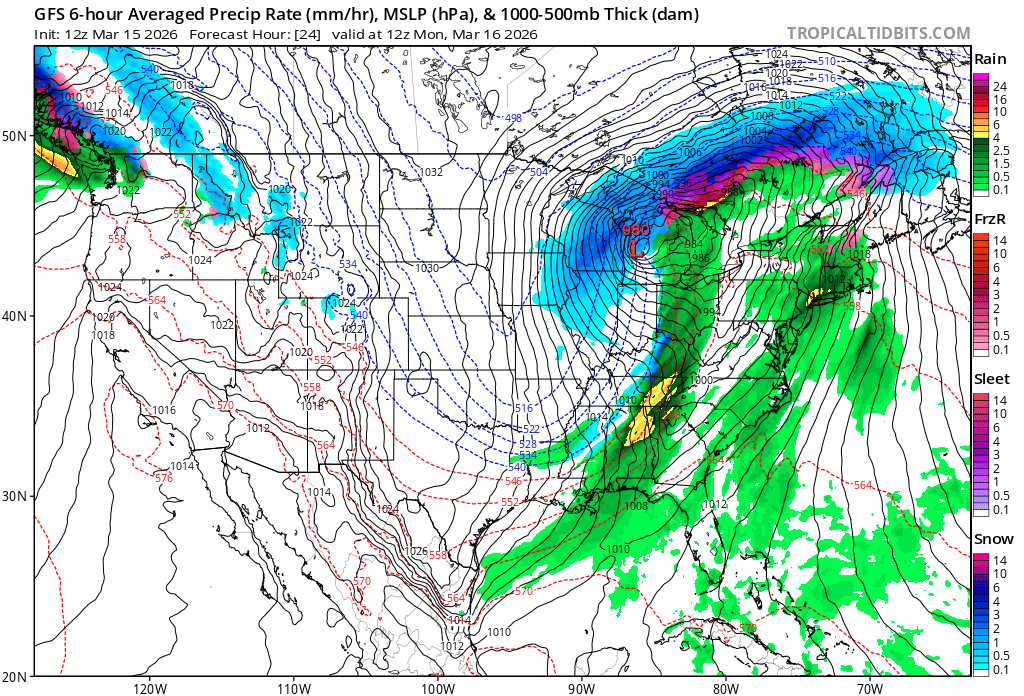
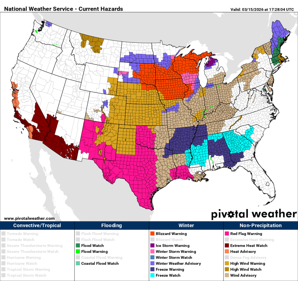
Dear Diary. Yesterday we dealt with a historic March heatwave for the West. On the flip side of an extremely amplified jet stream pattern that has led to record western heat, we have a cold eastern trough. There a winter storm that meets blizzard criteria in a broad area across the northern tier of states just before the spring equinox is not that rare, but the amount of snow produced by what the Weather Channel has designated as Iona is historic:
So, here is where climate change as an ongoing result of our burning of fossil fuels comes in. Iona is interacting with the heat dome producing Heatwave Artex such that warm and moist air is bring funneled into the system. This makes the thermodynamics of Iona stronger in terms of higher winds and let’s the system squeeze out more moisture in terms of record amounts of snow as shown by Dr. Masters.
Here are more details on Blizzard Iona from the Washington Post:
These 11 cities could see heavy snow or severe thunderstorms this weekend – The Washington Post
These 11 cities could see heavy snow or severe thunderstorms this weekend
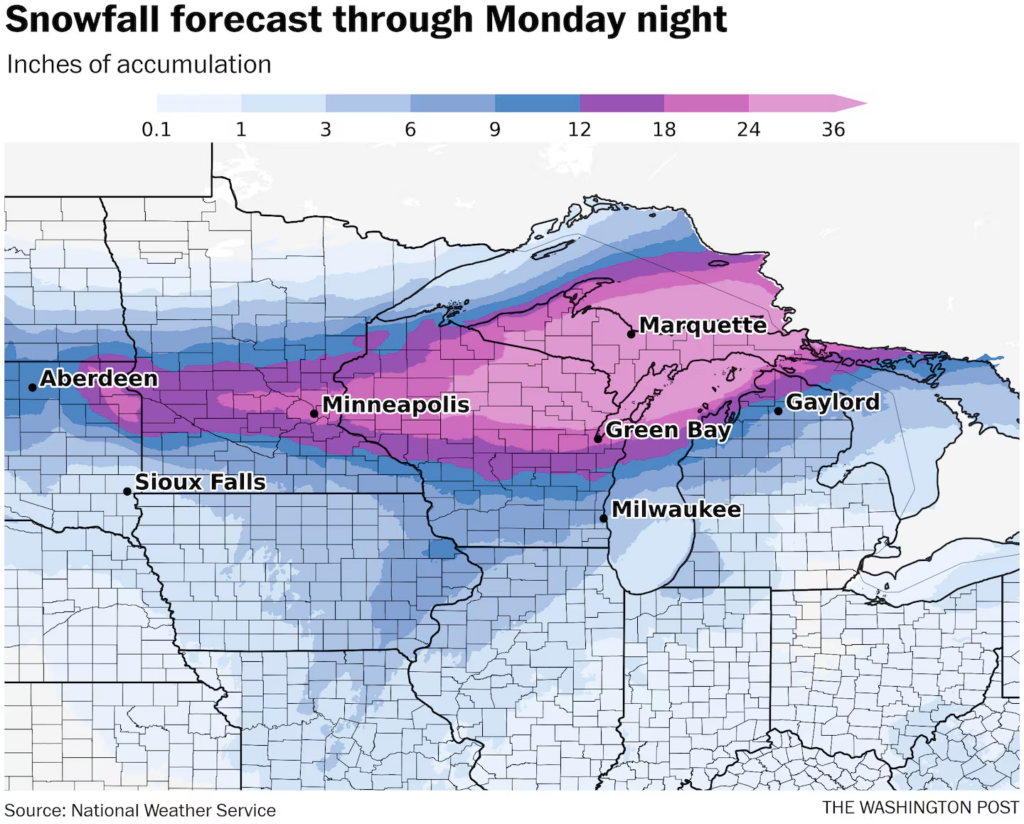
Snow totals of 10 to 30 inches will be widespread with some spots nearing 40 inches.
March 14, 2026 at 10:20 a.m. EDT

The Stone Arch Bridge during a winter storm in Minneapolis on April 11, 2019. (Jenn Ackerman/For the Washington Post)
By Ian Livingston and Ben Noll
A severe late-season winter storm unfolds this weekend and into Monday across the northern tier of the central United States. The worst of the snow and wind and the likelihood of blizzard conditions is expected to target a stretch from the northern Plains to the Great Lakes.
Around 14 million people, mainly in the Upper Midwest, can expect moderate to locally extreme winter weather impacts from the storm.
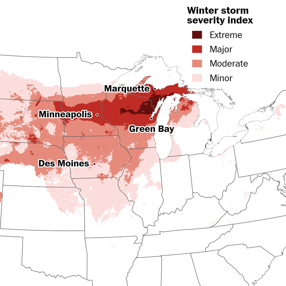
Around 14 million people in the Upper Midwest can expect moderate to locally extreme winter weather impacts through Monday. (Ben Noll/The Washington Post; NOAA)
Low pressure is forming on Saturday over the northern Rockies and adjacent northern high Plains. Developing snow bands will focus from Montana to central Minnesota, then shift eastward into Saturday night.
On Sunday, the storm will strengthen further while moving across the Midwest to around Chicago late day. From there, the powerful low pressure will track through lower Michigan and eventually into southeast Canada on Monday.
Across eastern South Dakota, through the Minneapolis region and central Minnesota, then to the northern half of Wisconsin and into northern Michigan, heavy snow and whiteout conditions are probable. A zone just north of the low-pressure track, particularly southern Wisconsin through the northern half of lower Michigan, is where freezing rain and sleet will cause additional concerns.
On the south side of the low-pressure zone, from the Mississippi Valley and Midwest to the Mid-Atlantic and Southeast, severe thunderstorms are expected to rumble. There is potential for numerous strong wind gusts and possibly tornadoes.
Snow and blizzard conditions through Monday
Snow totals of 10 to 30 inches should be common in the maximum strip north of the storm system, from eastern South Dakota through Michigan’s Upper Peninsula and into Ontario. From north-central Wisconsin through the Upper Peninsula of Michigan there is potential for higher totals, with some spots perhaps nearing 40 inches of snow.
Aberdeen, South Dakota
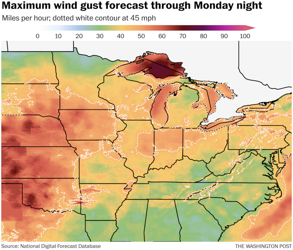
A blizzard warning is in effect for Aberdeen and surrounding regions of northeast South Dakota into western Minnesota. Wind gusts in excess of 50 mph are possible during the peak of the storm Saturday night through Sunday morning. Six to 10 inches of snow is forecast, while whiteout conditions are expected to make travel dangerous to impossible. Some wind damage is possible.
Sioux Falls, South Dakota
Blizzard warnings are north of the Sioux Falls but could expand to include the city.
While snow totals won’t be too notable in southeast South Dakota, wind gusts will rise to 50 or 60 mph. Mixed precipitation Saturday night turns to all snow for Sunday morning in Sioux Falls, leading to about 2 to 4 inches of accumulation. Blowing snow will lower visibility and cause drifting.
(Ian Livingston/The Washington Post; NOAA)
Minneapolis
Snow moves into the Twin Cities on Saturday evening and turns heavy at times Saturday night. There could be some thundersnow in the area as a low pressure intensifies while passing to the south.
About 12 to 24 inches is expected, and anything 16.5 inches or greater would crack the top 10 snowstorms. Wind gusts reach about 40 or 45 mph with lows in the 20s Saturday night and highs around 30 on Sunday.
Green Bay, Wisconsin
Snow will arrive late Saturday. It may mix with sleet, freezing rain and some rain on Sunday. Wind gusts increase to about 45 mph during the day as highs briefly rise near or a touch above freezing.
It’s back to all snow Sunday night and lingering into Monday before tapering. About 10 to 20 inches is anticipated in the city. Highs in the 20s as the storm ends.
Milwaukee
Snow or a snow-and-rain mix moves in during the predawn Sunday. As low pressure makes its closest pass, precipitation should mainly fall as rain while temperatures rise to around 50.
Wind gusts pick up to 45 or 50 mph into Sunday night as rain turns to snow and turns moderate to occasionally heavy. Winds cause blowing snow into Monday morning, and highs only reach the mid-20s. Total accumulation should be around 3 to 6 inches.
(Ian Livingston/The Washington Post; NOAA)
Marquette, Michigan
Cold air settles in as the storm starts, with lows around 20 Saturday night and snow beginning in the predawn. Only up to about mid-20s Sunday as snow turns heavy.
The snow will blow around in wind gusts of 50 mph or higher through Sunday and into Monday, with the potential for blizzard conditions. This region could be near the maximum impact from the storm. Snowfall of 20 to 30 inches is possible and so are wind chills below zero. Totals of 28.6 inches or greater would crack the top 10 two-day snowfalls.
Gaylord, Michigan
The north-central portion of lower Michigan will deal with wintry mix at the height of the storm, cutting down potential snowfall accumulation. Some spots could see a quarter- to a half-inch of ice, which could lead to power outages.
Snow that arrives before sunrise Sunday persists through the morning before mixing with freezing rain and sleet during the afternoon. A mix may continue through Sunday night into early Monday before precipitation changes back to snow. Gusts of 30 to 40 mph are possible, and about 6 inches of snow is anticipated.
Severe thunderstorms Sunday and Monday
While severe weather is not expected to be as widespread or significant as early March storm systems, large portions of the eastern United States are at risk.

Numerous states have tornado and damaging wind risks on Sunday. (Ben Noll/The Washington Post; NOAA)
Memphis
A squall line — a linear band of thunderstorms — will probably develop over Arkansas and Missouri on Sunday afternoon and then shift east. By evening, it should move into western Tennessee, including Memphis. Wind damage is a primary threat, although embedded tornadoes are possible.
Indianapolis
It’s a similar story farther east in Indianapolis. Since the city is farther north, there may be less fuel in the way of deep moisture and warmth. Thunderstorms will also pass later at night. Wind damage is the main threat with an isolated tornado possible.

There’s an enhanced risk (Level 3 out of 5) for severe thunderstorms on Sunday and Monday in some Central and Eastern states. Several tornadoes are possible along with the potential for widespread damaging winds. (Ben Noll/The Washington Post; NOAA)
Charlotte
A broken line of showers and thunderstorms moves by Atlanta in the predawn and toward Charlotte early Monday. The time of day may limit the severity of storms, but isolated to scattered wind damage is a threat.
Washington, D.C.
It’s on the muggy side Monday in the nation’s capital as the strong cold front careens that direction. During the afternoon or evening, a line of intense thunderstorms rolls out of the Appalachians and toward the coast. There is potential for scattered to numerous severe wind gusts around 60 mph, and possibly an isolated tornado.

By Ian Livingston Ian Livingston covers extreme weather and climate. He is also forecaster and information lead for the Capital Weather Gang.

By Ben Noll Ben Noll is a meteorologist passionate about explaining the why behind the weather, extreme events and climate trends. He has expertise in data analysis, supercomputer-driven graphics and forecasting weather worldwide. follow on X@BenNollWeather
Here are some “ETs” recorded from around the U.S. the last couple of days, their consequences, and some extreme temperature outlooks, as well as any extreme precipitation reports:
Here is More Climate News from Sunday:
(As usual, this will be a fluid post in which more information gets added during the day as it crosses my radar, crediting all who have put it on-line. Items will be archived on this site for posterity. In most instances click on the pictures of each tweet to see each article. The most noteworthy items will be listed first.)