The main purpose of this ongoing blog will be to track planetary extreme, or record temperatures related to climate change. Any reports I see of ETs will be listed below the main topic of the day. I’ll refer to extreme or record temperatures as ETs (not extraterrestrials).😜
Main Topic: Australia’s South and East set for Drier and Hotter Winter as BoM Forecasts Strong El Niño
Dear Diary. Strong El Niños have major consequences. One area of the planet that is directly affected is Australia. All ENSO model guidance points to a strong El Niño developing by July, so Australian forecasters are fairly confident about temperature and precipitation patterns across that island continent for this coming winter.
Hot and dry conditions should set up for most of eastern and southern Australia, but since it will be the winter, life threatening heat is not expected. Still, we will need to watch for drying brush that could lead to devastating bushfires later in Australia’s spring and next summer. We saw this play out during the 2019-2020 season known as the Black Summer bush fires that burned over 24 million hectares of land with horrible human and environmental consequences.
Mix a strong El Niño in with climate change and that concoction could be devastating for Australia. Here are more details from the Guardian:
Australia’s south-east set for drier and hotter winter as BoM forecasts potential El Niño
Queensland and NSW set for lower than usual rainfall in May, June and July, while temperatures in most of the country likely to be higher than normal
- Follow our Australia news live blog for latest updates
- Get our breaking news email, free app or daily news podcast

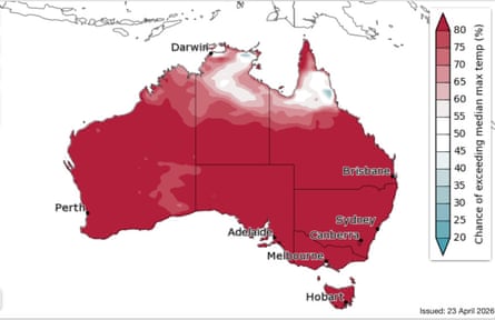
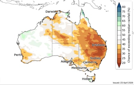
The sun rises in Sydney, NSW. Drier weather conditions are expected to be concentrated in NSW and Queensland in May, June and July 2026 due to El Niño. Photograph: Mike Bowers/The Guardian
Mon 27 Apr 2026
Large parts of south-east Australia look set for drier and hotter conditions over the next three months as a potential El Niño weather phenomenon takes shape in the Pacific Ocean.
Much of Queensland and New South Wales are forecast to have lower than usual rainfall in May, June and July, with almost the entire country likely to experience hotter than average maximum temperatures.
The World Meteorological Organization said last week there was an increasing chance of an El Niño developing in the Pacific – a phenomenon that historically has increased the chances of hotter and drier conditions for Australia’s east.
El Niño events also tend to push up global temperatures, with some climate experts saying an event later this year could help set global heat records in 2027.
El Niño is characterised by warmer than usual ocean waters in the tropical Pacific and a weakening or reversal of easterly trade winds which can both keep cloud and rain away from Australia’s east.Sign up for the Breaking News Australia email
The Bureau of Meteorology has said there is still disagreement among weather models, but most show sea surface temperatures consistent with an El Niño could be in place by July.
Caitlin Minney, a climatologist at the Bureau of Meteorology, said a developing El Niño was likely one of the factors behind the dry forecast.
“May to July looks like rainfall will likely be below average for much of eastern Australia,” she said.
While the drier conditions are expected to be concentrated in NSW and Queensland, the forecast also suggests parts of northern and western Victoria, southern parts of South Australia and the south-west of Western Australia could also be dry.
The bureau is also watching conditions in the Indian Ocean where some models are suggesting ocean temperatures to Australia’s north-west could cool – another phenomenon that can lower the chance of rainfall over the continent.skip past newsletter promotion
Dr Peter van Rensch, a climate scientist at Monash University, led a study last year into the affects of the cycle of warming and cooling in the Pacific – known as the El Niño-Southern Oscillation – on Australian rainfall.
He said El Niño’s influence on Australian rainfall has historically been at its greatest in the months of June and July and October and November.
“The pattern of the rainfall [in the bureau’s forecast] does look similar to what we would expect from the historical relationship with El Niño.
“A lot of the models are showing this [El Niño] will be strong, but there’s a lot that can happen in Pacific that could change that,” he said.
While there has been some commentary that a so-called “super El Niño” could develop, the bureau warned last week forecasts at this time of year tended to be less reliable.
The bureau also said the strength of an El Niño did not necessarily mean the impacts of an event on Australia’s rainfall would also be strong.
Van Rensch said the impacts of El Niño on Australia can also be influenced by the location of the warmest waters in the Pacific. El Niños that were concentrated in the central Pacific, as opposed to further east, tended to have the strongest affects on Australia.
The bureau’s long-range forecast is also showing the bottom two-thirds of Australia has an increased chance of unusually high maximum temperatures from May to July.
“The climate change signal is coming through very strongly in our temperature forecasts,” said Minney.
Global heating, caused by the burning of fossil fuels and deforestation, has warmed Australia by about 1.5C since 1910.
Here are some “ETs” recorded from around the U.S. the last couple of days, their consequences, and some extreme temperature outlooks, as well as any extreme precipitation reports:
Here is More Climate News from Tuesday:
(As usual, this will be a fluid post in which more information gets added during the day as it crosses my radar, crediting all who have put it on-line. Items will be archived on this site for posterity. In most instances click on the pictures of each tweet to see each article. The most noteworthy items will be listed first.)