The main purpose of this ongoing blog will be to track planetary extreme, or record temperatures related to climate change. Any reports I see of ETs will be listed below the main topic of the day. I’ll refer to extreme or record temperatures as ETs (not extraterrestrials).😜
Here is a new feature for this blog, which I will add daily. This is the latest inciteful Green News Report from my friends Desi Doyen and Brad Friedman at Progressive Voices. Hit ‘continue reading,’ listen, then hit return to see my daily topics:
Main Topic: U.S. Heatwave Bluestone Gets Very Strong This Week
Dear Diary. On Saturday we saw the advent of U.S. major Heatwave Bluestone since a large area of National Weather Service heat warnings were posted across the Midwest. On this Monday areas if heat warnings/advisories have greatly expanded through the South with watches in the Northeast:
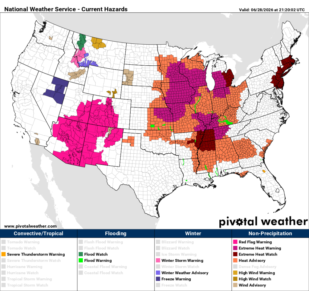
Associated red flag or fire watches remain for much of the Southwest.
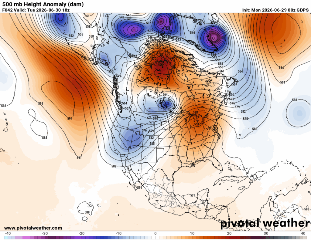
Thankfully Bluestone’s heat dome will not get up to 598 decameters at its peak aa had initially forecast by models. The thing should get up to about 596 decameters over the mid-Atlantic area by Tueaday. That 2-decameter difference doesn’t seem like much, but it could limit widespread all-time records from occurring:
The first fatalities from Bluestone cone from western wildfires. Here is a writeup about that and another one describing what residents will be facing this week from excess heat:
Severe heat, strong winds spur raging wildfires in Colorado and Utah – The Washington Post
Severe heat, strong winds fuel raging wildfires in the West
Three firefighters were killed batting the flames as 79 fires swept across 11 states.
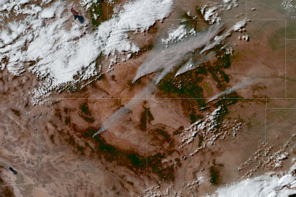
Wildfires burn across drought-stricken Utah, Colorado, Arizona and New Mexico late Sunday, with their smoke plumes extending for hundreds of miles. (Ben Noll/The Washington Post; NOAA)
By Sarah Kaplan and Ben Noll
A weekend of dangerous conditions spurred the growth of scores of wildfires raging across the West — including a blaze that killed three federal firefighters.
As of Monday morning, crews were battling 79 total fires, including 52 large, uncontained blazes, across 11 states. Gusty winds and low humidity, which increase the risk of unpredictable and fast-spreading wildfires, prompted the National Weather Service to issue Red Flag warnings for most of Colorado along with large swaths of Utah, Arizona, Wyoming and New Mexico.
The three federal firefighters were killed in Colorado on Saturday as severe heat, strong winds and vegetation parched by a historic drought combined to give rise to an explosive Knowles Fire along the Colorado-Utah border, according to the U.S. Wildland Fire Service.
Emily Barker, 38, Nick Hutcherson, 27, and Sydney Watson, 27, had been assigned to the Rifle Helitack crew — a highly trained unit that specializes in quickly suppressing new fires in rugged terrain.
Amid powerful wind gusts and temperatures of more than 90 degrees, the fast-moving blaze suddenly overtook the crew, forcing them to deploy emergency shelters designed to reflect heat and trap breathable air. Two others who survived the incident are being treated for burn injuries, the agency said.
“We mourn the loss of three firefighters who answered the call to protect others and made the ultimate sacrifice in service to their fellow citizens,” U.S. Wildland Fire Service Chief Brian Fennessy said in a statement Monday.
Since Saturday, the Knowles Fire has combined with several others to become the Snyder Fire, which currently encompasses more than 28,000 acres in both Colorado and Utah.
Nearly 300 miles to the west, near the town of Beaver, Utah, the Cottonwood Fire has grown to more than 93,000 acres since it started a week ago. Now the largest blaze in the country, it was completely uncontained as of Monday morning, and Utah Gov. Spencer Cox has estimated it could be the most destructive in the state’s history.
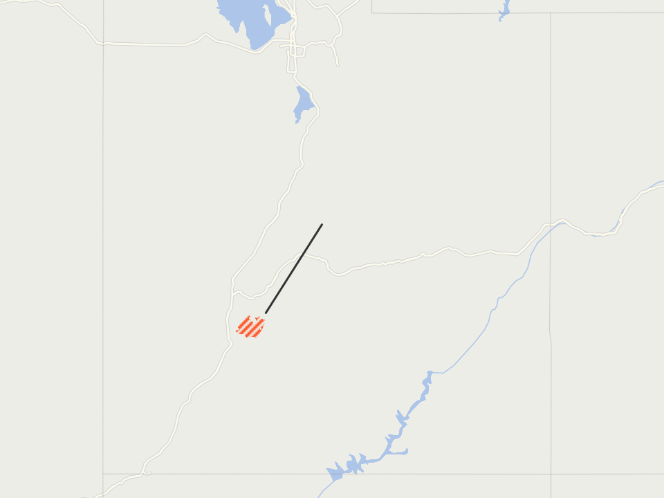
As of 6 a.m. EDT Monday Source: NIFC
The ongoing extreme fire weather is likely to test the fledgling Fire Service, which the Trump administration launched in January as part of an effort to unify the government’s disparate firefighting forces. Many firefighters and independent experts praised the establishment of a more centralized agency, saying it would better prepare the country to cope with longer and more extreme fire seasons fueled by climate change.
But rarely has the U.S. seen a wildfire season as severe as this one is likely to become. A historically dry winter has left much of the Western snowpack at record lows, turning vast swaths of forest into tinder. Nearly 3 million acres across the country have already burned, 60 percent more than the 10-year average.
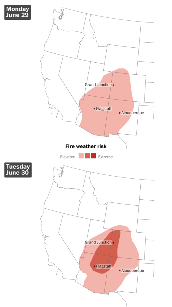
Fire weather risks have been elevated to critical across a swath of the Intermountain West for Monday and Tuesday as dry and breezy conditions continue. (Ben Noll/The Washington Post; NOAA/SPC)
Since mid-June, the nation’s fire preparedness status has been rated at 3, meaning that officials are having to prioritize among competing demands for resources — a level typically not reached until July.
Fire weather risks will increase across the region on Tuesday as a disturbance in the upper atmosphere swings across the region, according to the Weather Service. It won’t bring rain to the drought-stricken land, but it will cause more wind.
Smoke from the fires is blowing eastward, with air-quality alerts in effect across Denver, Boulder and Fort Collins in Colorado.
Although it wasn’t reducing air quality on the ground, smoke lofted higher in the atmosphere was blowing across the Dakotas into Canada early Monday. On Tuesday, that high-level smoke could create hazy skies in parts of the Midwest and Great Lakes regions as it blows farther east.
Little or no rain is forecast over the next two weeks across the area where wildfires are spreading.
Now more about that heat:
Dangerous heat wave to scorch much of U.S. as Fourth of July nears
Dangerous heat wave to scorch much of U.S. ahead of July Fourth, with historic highs possible
Millions across the central and eastern U.S. could face days of triple-digit heat index values.
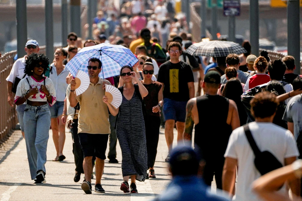
People walk along the Brooklyn Bridge during an extreme heat warning in New York last year.Eduardo Munoz / Reuters fileShare
June 28, 2026, 2:01 PM EDT / Updated June 28, 2026, 8:08 PM EDT
By Christine Rapp and Dennis Romero
An intense and prolonged heat wave could bring record temperatures to the central and eastern United States ahead of Independence Day celebrations.
Nearly 142 million people were under National Weather Service heat alerts, with that number likely to grow as heat moves toward the Southeast, Midwest and Northeast.
“The latest guidance continues to strongly agree on a potentially historic heatwave across the eastern third of the country for the end of the week,” the weather service said in a forecast discussion Sunday.
The weather service added that Thursday and Friday could face “the possibility of all-time record highs” in places.
Cities including Chicago; Kansas City and St. Louis, Missouri; Nashville, Tennessee; Savannah, Georgia; Philadelphia; and Boston are under alerts, with daytime highs expected to climb into the 90s and the 100s.
The weather service’s forecast discussion for Kansas City said the stubborn heat could last through the Fourth of July. “We expect to be locked into a hot and dry pattern through at least Thursday, but probably through Saturday,” it said.
As the wave reaches the East midweek, the heat index value could surge past 100 degrees Fahrenheit in Philadelphia and Washington, with Philadelphia feeling as hot as 112 by Thursday.
The weather service office for New York City issued an extreme heat watch for the region that covers Monday through Wednesday. It notes the “feels like” temperature, known as the heat index, is forecast to reach 108.
Factoring in the humidity, heat index values could reach 105 to 114 in other places under the dome through the week.
Highs across the East and Southeast will generally be 5 to 10 degrees above normal as the wave spreads eastward, with a few records possible in Florida’s Key West, Miami, Orlando and Tampa.
Recommended

HeatAround 145 million at risk as U.S. braces for holiday week heat wave; wildfires continue to rage in the West

U.S. newsKentucky flash floods kill at least four, with rescue operations ongoing
Much of the Southwest was already facing highs of around 100.
Fire weather conditions, including continued dry air and gusts up to 30 mph, will persist in much of Arizona, eastern Utah, western Colorado, western New Mexico and parts of southern Wyoming, according to the weather service.
Utah, Colorado and other states in the West have been subjected to large-scale weekend wildfires, including the 93,607-acre Cottonwood Fire, where 1,200 firefighters and support personnel had achieved zero containment by late Sunday afternoon, according to a joint command update. Along the Utah-Colorado border, three firefighters assigned to two other fires were killed on the job Saturday, federal officials said.
A series of cooler air pulses from the west will push the weekend’s dry heat to the east, where it will park over the Tennessee Valley as it expands, federal forecasters said.
Such a high-pressure dome pushes air toward Earth, heating it as it descends.
A cold front from the northern Plains — Wyoming, Montana and the Dakotas — could clash with the heat dome to the south, producing thunderstorms in the Mississippi Valley through Monday, the weather service said.
Across the Atlantic, a historic heat wave sweeping Europe has turned deadly. French officials said the country recorded about 1,000 excess deaths during the recent stretch of record-breaking heat.
A study by earth scientists based in the U.S., Australia and China published last year found that “global warming is responsible for long-term increases in the frequency and strength of concurrent heat extremes,” according to a summary.
Christine Rapp is a meteorologist for NBC News.

Dennis Romero is a breaking news reporter for NBC News Digital.
Emma Caughlan contributed.
Here are some “ETs” recorded from around the U.S. the last couple of days, their consequences, and some extreme temperature outlooks, as well as any extreme precipitation reports:
Here is More Climate News from Monday:
(As usual, this will be a fluid post in which more information gets added during the day as it crosses my radar, crediting all who have put it on-line. Items will be archived on this site for posterity. In most instances click on the pictures of each tweet to see each article. The most noteworthy items will be listed first.)