The main purpose of this ongoing blog will be to track planetary extreme, or record temperatures related to climate change. Any reports I see of ETs will be listed below the main topic of the day. I’ll refer to extreme or record temperatures as ETs (not extraterrestrials).😜
Here is a new feature for this blog, which I will add daily. This is the latest inciteful Green News Report from my friends Desi Doyen and Brad Friedman at Progressive Voices. Hit ‘continue reading,’ listen, then hit return to see my daily topics:
Dear Diary. Over the last week I’ve reported on a large historic heatwave that I’ve dubbed Conoco Phillips. It’s quite unusual because its elongated heat dome has set up over the northern tier of states. As of this morning 500 millibar heights are decreasing across the Upper Midwest, but the system remains strong:
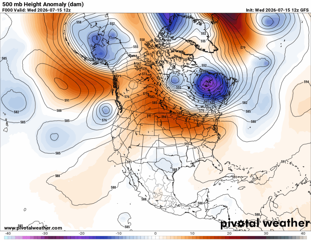
Typically, that heat dome would be over Texas, and the cool upper-level low over Texas would be over Michigan or Illinois. We now live in opposite world thanks to climate change. The heat dome is at high latitudes and has trapped residual cool pockets to its south, which aren’t moving very fast. One of these has set up an extreme flooding pattern in South Texas At this point in the 21st century, we will see unusual weather patterns like the current one, but they will revert to climatological norms as will happen by next week:
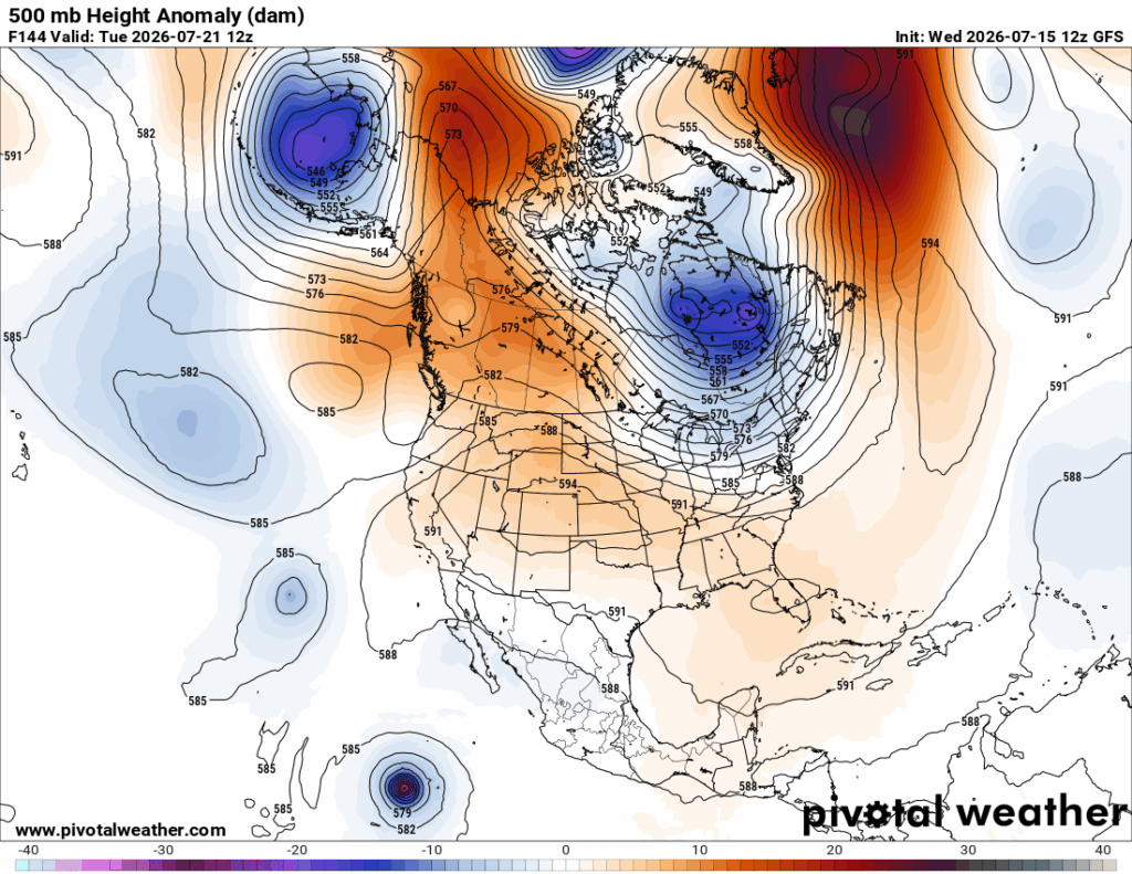
The awful consequence of this is yes heat and extensive wildfire smoke, but the most devastating part of the current weather pattern is flooding across portions of Texas. I fear the loss of life and extensive widespread loss of property for what is happening near San Antonio Texas. I will be adding more information on the flooding as it crosses my radar on subsequent Diary posts the next few days.
Here are some details from USA Today:
Central Texas faces life-threatening flash flooding through Thursday
Flash floods continue in Texas after storms dump 1 foot in some areas
Dangerous flash flooding is expected to persist as stalled storms dump inches of new rain and send rivers rising across South Central Texas through Thursday.
USA TODAY NETWORK
Updated July 15, 2026, 12:41 p.m. ET
Flash flooding continues across South Central Texas as thunderstorms train over the same areas, dumping up to a foot of rain and triggering water rescues and road closures.- The greatest flood threat is along the U.S. 90 corridor west of San Antonio, where Uvalde County and nearby communities face life-threatening flash flooding and rising rivers.
- The Weather Prediction Center has placed parts of South Central Texas under a High Risk, Level 4 of 4, for excessive rainfall, its highest category for dangerous flash flooding.
- Forecasters warn that rivers including the Pecos, Rio Grande, Nueces, Frio, Medina and San Antonio could see significant downstream flooding well after the heaviest rain ends.
Flash flooding continued across parts of South Central Texas on Wednesday after repeated rounds of thunderstorms dumped up to a foot of rain in some areas, prompting water rescues, road closures and warnings that the worst flooding may not be over.
The National Weather Service warned that additional rounds of torrential rain are expected through Thursday, with some locations potentially receiving another 10 to 20 inches of rainfall on top of what has already fallen.
“The forecast remains relatively unchanged with intense rain rates and compounding effects from multiple rounds of storms resulting in a dangerous flash flooding threat through Thursday,” the National Weather Service in Austin wrote in the area forecast discussion. “Considerable to locally catastrophic impacts from flash flooding are likely for portions of the U.S. 90 corridor west of San Antonio, including the southern Edwards Plateau and Rio Grande.”More: Watch Texas flash flooding after storms dump up to 12 inches of rain
Dangerous Flooding Continues:
Forecasters said a stalled weather pattern has allowed thunderstorms to repeatedly move over the same areas, producing rainfall rates of 3 to 4 inches per hour overnight.
The greatest threat stretches along the U.S. 90 corridor west of San Antonio, including portions of the southern Edwards Plateau and Rio Grande Plains. Uvalde County has been among the hardest-hit areas.
The Weather Prediction Center continues to place much of the region under a High Risk (Level 4 of 4) for excessive rainfall through Thursday — the agency’s highest category for life-threatening flash flooding.
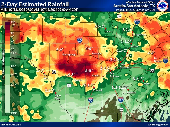
Broader rainfall totals of 2 to 6 inches are expected across much of South Central Texas, while isolated locations within the highest-risk corridor could see another 10 to 20 inches if storms repeatedly track over the same communities.
Texas rain totals
River flooding expected to worsen
Beyond flash flooding, forecasters warned that rivers and streams could continue rising well after the rain ends.
Significant downstream flooding is possible along the:
- Pecos River
- Rio Grande
- Nueces River
- Frio River
- Medina River
- San Antonio River
Officials warned that creeks and normally dry arroyos can rise rapidly with little warning, especially overnight when floodwaters are more difficult to see.
More rain through Friday before conditions improve
Rain chances should begin decreasing across eastern parts of the region by Friday and through the weekend, although isolated showers and storms could linger in western areas. Drier weather is expected to return early next week, along with temperatures climbing back into the 90s.
Brandi D. Addison covers weather across the nation as the Weather Connect reporter for the USA TODAY Network and contributes to Texas Connect coverage across the state. She can be reached at baddison@usatodayco.com. Follow her on Facebook here
Here are some “ETs” recorded from around the U.S. the last couple of days, their consequences, and some extreme temperature outlooks, as well as any extreme precipitation reports:
Here is More Climate News from Wednesday:
(As usual, this will be a fluid post in which more information gets added during the day as it crosses my radar, crediting all who have put it on-line. Items will be archived on this site for posterity. In most instances click on the pictures of each tweet to see each article. The most noteworthy items will be listed first.)