The main purpose of this ongoing blog will be to track planetary extreme, or record temperatures related to climate change. Any reports I see of ETs will be listed below the main topic of the day. I’ll refer to extreme or record temperatures as ETs (not extraterrestrials).😜
Here is a new feature for this blog, which I will add daily. This is the latest inciteful Green News Report from my friends Desi Doyen and Brad Friedman at Progressive Voices. Hit ‘continue reading,’ listen, then hit return to see my daily topics:
Dear Diary. It has been about a week since I forecast another major heat event, which I dubbed Heatwave Kock, that will bake the Plains and West:
The system did become a CAT3 using my criteria on Monday of last week:
Yesterday the system nearly became a historic CAT4 because it began to set all-time records:
Here is Heatwave Koch’s heat dome status as of this Sunday:
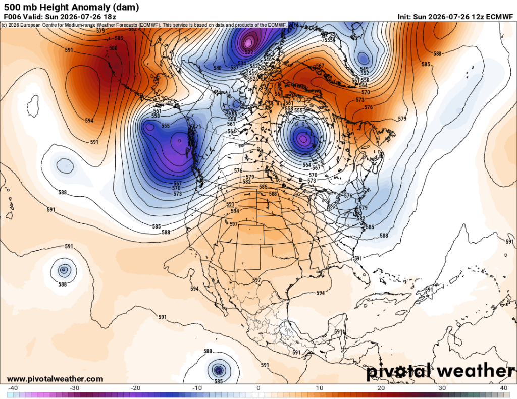
On the above Pivotal Weather chart, we have a near 599 decameter ridge centered over the Colorado/New Mexico border. This setup has produced a strong CAT3 heatwave border lining on a historic CAT4 provided that we start to see multiple all-time records. Heat warnings and advisories are very extensive today:
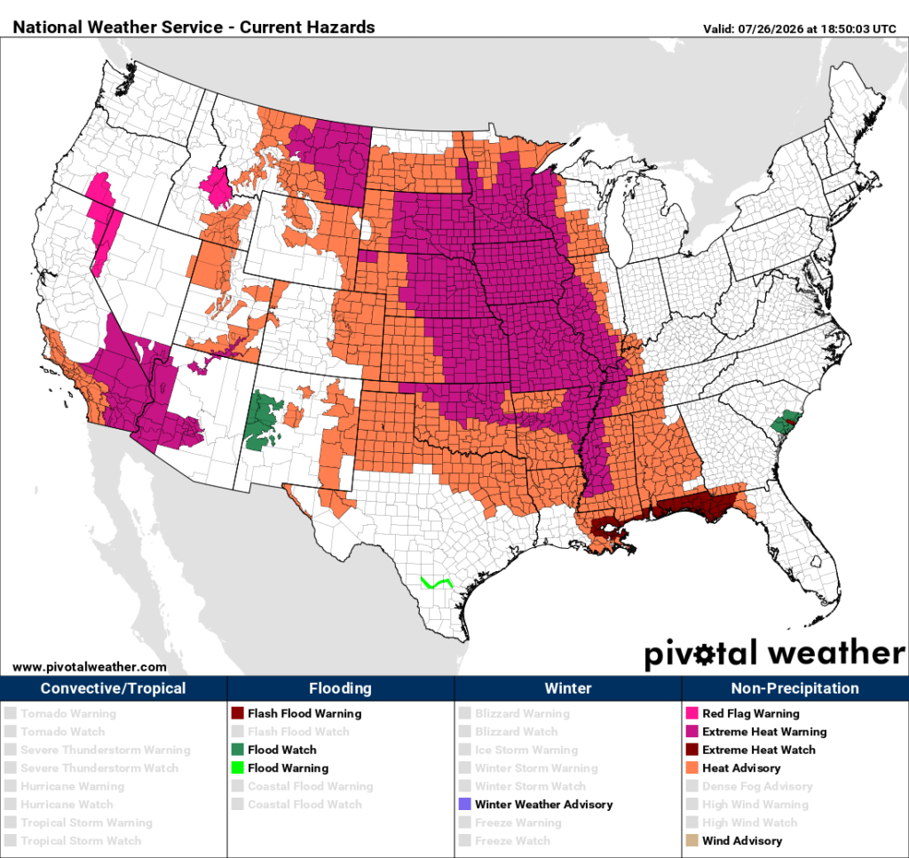
The good news here is that Koch’s heat dome peaked today. The system should remain in place but decrease to about 595 decameters by Thursday. This means that a front will cool much of the Plains by Midweek, and the Southeast will just see a few days of extreme heat to start this week before that same front cools that area as well.
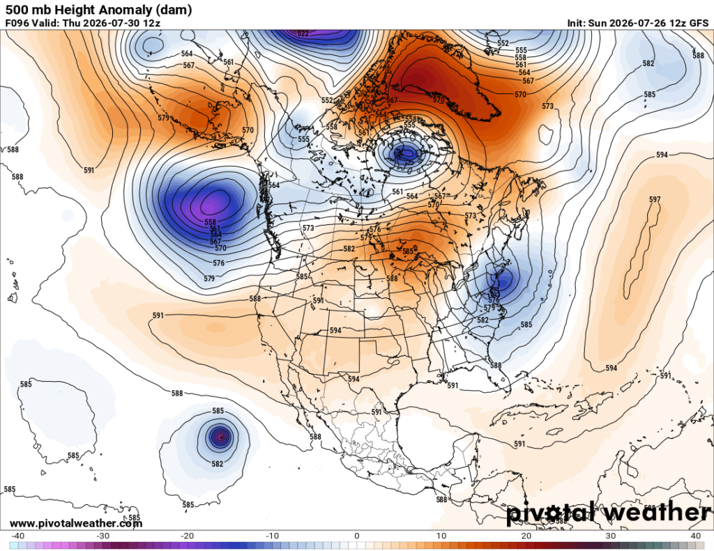
The bad news is that Koch will peak again over the Southwest by next weekend, meaning that this area of the country will see a very prolonged and dangerous heatwave lasting well more than a week:
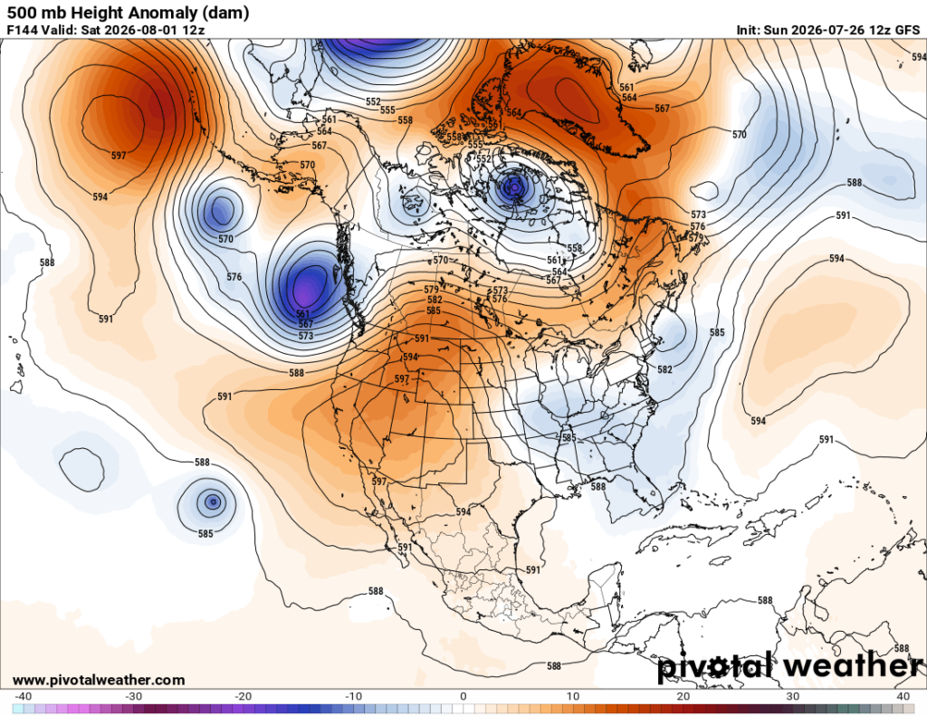
I’ll be issuing daily updates on Heatwave Koch this week with another ETD post by week’s end.
Here is a summary of what is expected from Heatwave Koch from the Washington Post:
Heat dome to bring record-topping temperatures of 110 degrees – The Washington Post
The planet’s strongest heat dome will soon tower over the Rockies and Plains
See where record-toppling temperatures of 110 degrees are possible through next week.
July 24, 2026
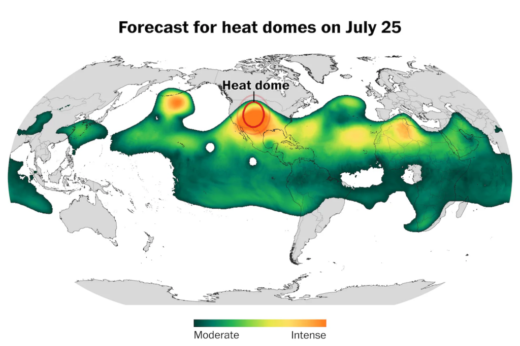
On Saturday, the planet’s strongest heat dome will be found over the central United States. It will linger through much of next week. (Ben Noll/The Washington Post; ECMWF)
AI Overview
Record-breaking heat domes have dominated the summer, with Europe and the U.S. experiencing extreme temperatures. A powerful heat dome is set to intensify over the Plains and Rockies, threatening more records. According to the National Weather Service, dangerous heat will expand into the central U.S. and Gulf Coast, with drought risks in the Plains and Midwest. Rising global temperatures contribute to these unprecedented extremes.
AISummary is AI-generated, newsroom-reviewed.

By Ben Noll
It has been the summer of the heat dome.
Europe was hit by record-breaking heat events in May and June. Then, a slow-moving heat dome sizzled the East in early July, toppling records. After that, another sprawling heat dome spiked temperatures to 115 degrees in Montana, breaking yet more records.
And now, another heat dome — predicted to strengthen Saturday into the most powerful one on the planet at that time — is threatening to break more records across the Plains and Rockies.
Heat domes are towering and slow-moving areas of high pressure that trap hot air — and they often lead to heat waves.
This expansive area of high pressure could send temperatures surging past 110 degrees in the central United States early next week, with the core of the most unusual heat stretching from the Dakotas to Texas. Several states in that corridor are dealing with drought.
High humidity will make the heat more dangerous. The number of very and extremely humid summer days has grown across the Plains as the Gulf of Mexico warms.
Here are the highest temperatures predicted through Wednesday in two dozen states that will feel the effects of this heat dome, according to the European Center for Medium-Range Weather Forecasts (ECMWF):
- California: 121 degrees
- Arizona: 120 degrees
- Nevada: 115 degrees
- Kansas: 113 degrees
- Oklahoma: 112 degrees
- Texas: 112 degrees
- South Dakota: 109 degrees
- Arkansas: 108 degrees
- Colorado: 107 degrees
- Idaho: 107 degrees
- Louisiana: 107 degrees
- Nebraska: 107 degrees
- New Mexico: 107 degrees
- North Dakota: 107 degrees
- Minnesota: 106 degrees
- Mississippi: 106 degrees
- Missouri: 106 degrees
- Tennessee: 106 degrees
- Utah: 106 degrees
- Montana: 105 degrees
- Wyoming: 104 degrees
- Alabama: 103 degrees
- Iowa: 102 degrees
- Wisconsin 101 degrees
Across the southern Plains, temperatures may rise even higher after next Wednesday. Records are possible across 32 states, including most of the ones listed above.
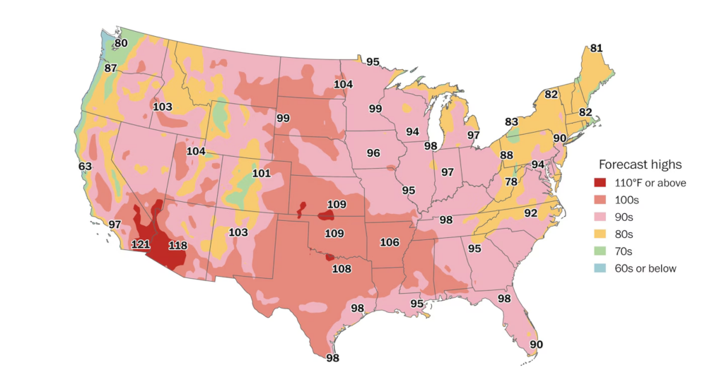
The highest temperatures predicted through July 29. Around 60 million people across the U.S. may experience triple-digit heat during that period. (Ben Noll/The Washington Post; ECMWF)
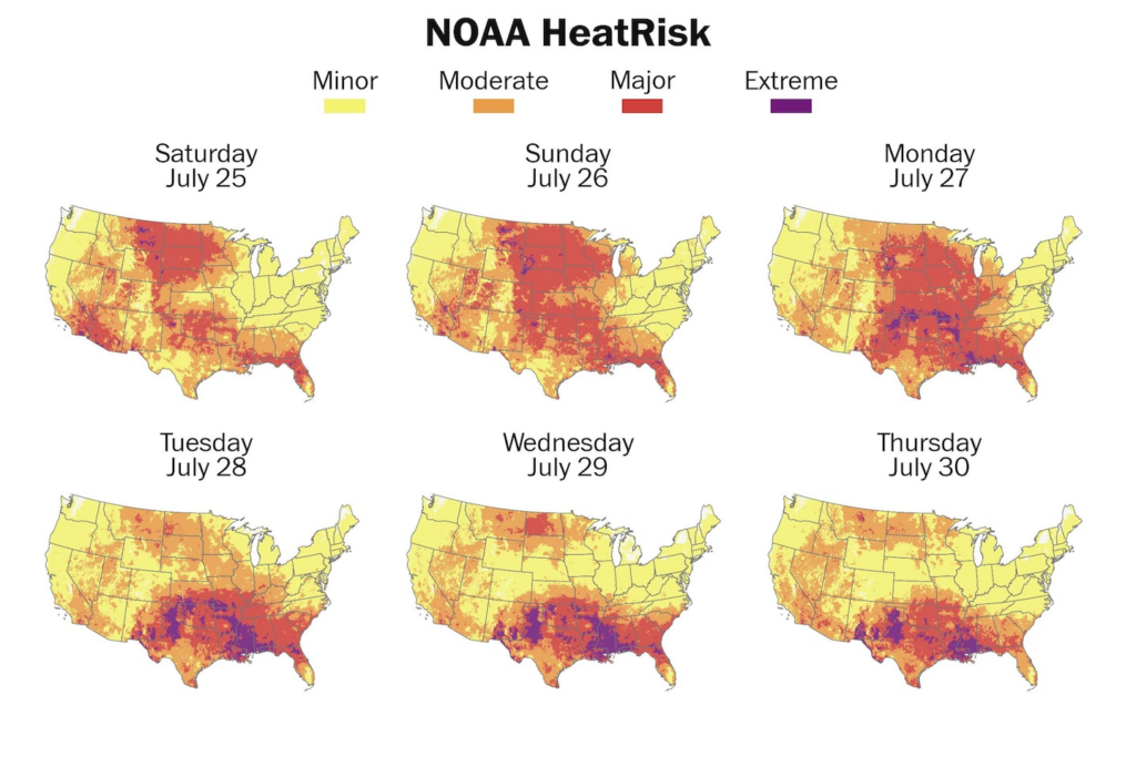
More than 100 million people across the West, Plains and Midwest could face major or extreme risk for heat-related impacts through July 30. At the rare extreme level, heat can be dangerous to anyone without access to effective cooling. (Ben Noll/The Washington Post; NOAA)
“Dangerous heat is building across parts of the West and Central U.S. through this weekend and will expand into the Central U.S. and Gulf Coast early next week,” wrote the National Weather Service, which also mentioned a risk of “rapid onset drought” in some areas of the Plains and Midwest, including portions of the Corn Belt.
Heat domes are not a new weather phenomenon, but these sprawling areas of high pressure and blazing sunshine are producing temperature extremes that are new for some areas — largely because of the background influence of rising global temperatures.
This blistering heat is forecast to linger across the southern Plains for much of next week before the heat dome pivots toward the West Coast next weekend.
Has it been a hot summer?
Heat has dominated weather headlines over the past several months.
That’s because it has been warmer than average across much of the United States since June, and record heat has been outpacing cold this year.
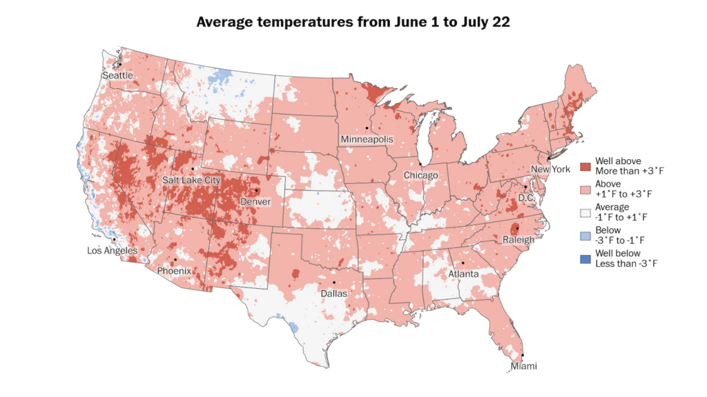
Around 280 million people across the United States have experienced warmer than average conditions so far this summer. (Ben Noll/The Washington Post; PRISM/Oregon State University)
During that period, just 2.8 million people experienced cooler-than-average conditions in pockets of coastal California, Montana and western Texas.
Meanwhile, around 280 million experienced above-average or well-above-average temperatures.
Some of the hottest places compared to average — all at least 2.5 degrees warmer than average — have been Utah, Nevada, Colorado, Massachusetts, and Maine.
D.C. is on that list, too — about 3 degrees warmer than average.
Looking ahead to early August, extreme heat could persist across parts of the Western and central U.S., while the East could avoid the most intense conditions.
By Ben Noll Ben Noll is a meteorologist passionate about explaining the why behind the weather, extreme events and climate trends. He has expertise in data analysis, supercomputer-driven graphics and forecasting weather worldwide. follow on X@BenNollWeather
Here are some “ETs” recorded from around the U.S. the last couple of days, their consequences, and some extreme temperature outlooks, as well as any extreme precipitation reports:
Here is More Climate News from Sunday:
(As usual, this will be a fluid post in which more information gets added during the day as it crosses my radar, crediting all who have put it on-line. Items will be archived on this site for posterity. In most instances click on the pictures of each tweet to see each article. The most noteworthy items will be listed first.)