Friday September 6th… Dear Diary. The main purpose of this ongoing blog will be to track United States extreme or record temperatures related to climate change. Any reports I see of ETs will be listed below the main topic of the day. I’ll refer to extreme or record temperatures as ETs (not extraterrestrials).😉
Late Summer U.S. Heat and Autumn Average Temperature Forecast + More Dorian News
Nine days of having Hurricane Dorian as our main headline subject is enough, don’t you think? I will include many more notes on Dorian in my news section, though. It will be a very windy day across the New England Cape area on Saturday, and Nova Scotia is likely to see a damaging landfall Saturday night. I got my wish that Dorian’s eyewall stayed away from Florida, Georgia and South Carolina. North Carolina wasn’t so lucky, but Dorian weakened to a CAT 1 before tangling with the Outer Banks area, so many prayers were answered. Keep praying for Nova Scotia, though, and do what you can for many poor souls that survived Dorian in the Bahamas.
As promised its now time to start turning our attention to a late summer heat wave that is gripping most of the southern tier of states. Here are notes I wrote yesterday:
And Wednesday of this week:
Speaking of “Hotlanta,” looking at the strength of this heat dome temperatures may approach the century mark, which would set records, by Monday, Tuesday, and Wednesday of next week:
I’m sure that a 594+ decameter ridge sitting over the Southeast and Middle Atlantic this time of the year won’t be welcome since we are supposed to be going into meteorological fall. The thing will set many warm nightly and hot daily records. Some monthly records will also be set.
Heat has diminished a tad in Atlanta in the wake of Dorian, but Saturday will still be much hotter than average for most of the southern states:

Speaking of autumn, because of Dorian I’m five days past due presenting my average temperature forecast for the continental U.S. I will be using the same broad techniques used to forecast the last several seasons:
Welcome to boreal fall everyone, or the three months that are September through November. Meteorologically and on climate summaries fall is considered to start on September 1st instead of when the autumnal equinox occurs later in the month. So how will fall 2019 stack up compared to long term temperature averages across the United States? Will we continue to see the climate crisis signature of warmer than average conditions? Let’s try to make a forecast as usual at the start of a new season.
So how did the forecast work out for summer 2019? Here is the post for that forecast:
Today the National Center for Environmental Information completed their assessment for summer 2019, so let’s fill in their numbers for a verification:

Rankings for the lower 48 states started in 1895, so the highest number would be 125. The summer started out cooler than average across the CONUS but got progressively hotter. I strongly suspect that this was because much long wave incoming solar radiation had to be spent drying up the water logged Plains and Midwest from the spring. As forecast ranking numbers got hotter, with August being the hottest,
All this means that as suspected the summer turned out to be above average, but not as hot as recent summers this decade looking at the ranking of 101 from 2019.
O.k. Now that we have established that our forecast was half decent for the last season let’s use the same techniques to forecast temperature rankings for this fall.
First, let’s look at current water temperatures anomalies surrounding North America:

Wow! The last El Nino, which is dead now, spewed enough heat into the atmosphere to really warm waters elsewhere across the Northern Hemisphere and around North America in particular. Don’t forget that we already have a radiation imbalance due to Carbon Pollution. I’d say that temperatures across just about all of the CONUS will be above average through the fall looking at the above chart.
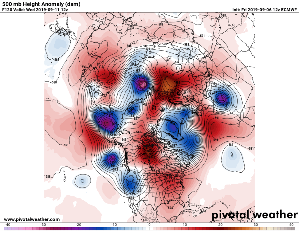
Second, I like to look at the strength of the Hudson Bay low or polar vortex at the start of any season:

This is the same chart we used to start today’s post. Nope. There is no Hudson Bay vortex present. I see a lot of red on this chart instead. I do see a chilly vortex over Greenland, though, but usually when one is in this position above average temperatures can be expected east of the Rockies, but it could just be transitory, or not very stable, perhaps reforming over Hudson Bay in a couple of weeks. There are an atrocious number of closed lows on the above chart, which is a climate change signature, but usually lead to an anstable weather pattern. In any case, this factor looks warm.
Here is the National Weather Service forecast for Fall 2019, which I agree with:

Overall, Fall 2019 will probably verify well above average.
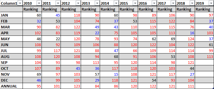
Last, we can get another clue looking at prior ranking and temperature record count data. For this I like to drag out that “Record Scoreboard” (updated through 9/6/2019):

Again here we see clues that summer started out cooler than average but got progressively hotter. June is colored “blue” because the ratio of daily high max to low min records are below one to one. July is colored “black” because the ratio of daily high max to min records are near one to one. August was colored “red” because the ratio of daily high max to min records was well above one to one..
As you can see September has already started out with more record high maxes than record minimums.
I expect this warming trend to continue through September then level off in October. November may be the coolest of the three months, relative average temperature wise, but all three months of Autumn should see an above average ranking of 62.
Not all seasons in the near future will see above average temperatures, but seasonal forecasters are beginning to”chuck it,” discounting colder than average scenarios due to carbon pollution.
Again, here are all seasons ranked for this decade:

Here was my bottom line forecast for Spring 2019:
“I think that this summer will be ranked below that of the last four. Carbon pollution is definitely making below average seasons more rare. I’m going to guess that the summer of 2019 ranking will be around 90 + or – 10, with average confidence given all of the factors in this post.” (Note that I was on the cool side by only 11 ranks.😃)
Notice that the past four falls had a ranking at or above 70, but that of 2018 was the coolest. The big El Nino of 2015/16 really spiked global temperatures as well as those for the U.S. From Fall 2018 through most of 2019 U.S. averages have gotten considerably lower than the torrid levels of 2016, though. Will increased global heat from the weak El Nino of early 2019 once again be a catlyst, helping to produce another “heat spell” for the United States? We will see.
As of 2019 the top ranking for any month or season would be 125 since climatological rankings for the United States started in the year 1895. I think that this fall will be ranked at least as high as 110. Carbon pollution is definitely making below average seasons more rare. I’m going to guess that the fall of 2019 ranking will be around 110 + or – 10, with above average confidence given all of the factors in this post.
We will see how this forecast pans out around December 1st.
More from NCEI:
Have a great fall!
…………………………………………………………………………………
Here is more news on Hurricane Dorian:
Here is more climate and weather news from Friday:
(As usual, this will be a fluid post in which more information gets added during the day as it crosses my radar, crediting all who have put it on-line. Items will be archived on this site for posterity. In most instances click on the pictures of each tweet to see each article.)
It’s still very warm in Alaska, one of the “ETs” reported from Friday:
(If you like these posts and my work please contribute via the PayPal widget, which has recently been added to this site. Thanks in advance for any support.)
Guy Walton- “The Climate Guy”