Thursday September 12th… Dear Diary. The main purpose of this ongoing blog will be to track United States extreme or record temperatures related to climate change. Any reports I see of ETs will be listed below the main topic of the day. I’ll refer to extreme or record temperatures as ETs (not extraterrestrials).😉
Very Odd, Hot Weather Pattern Continues For The United States Interacting With The Tropics
Sometimes, as has been happening more often after the turn of the 21st century, a hot or warm weather pattern develops that current meteorological models, which also crunch temperature forecasts, don’t handle very well. This is not surprising since most have traditional climatology built into equations used to run the things. The southern half of the United States has undergone a heat wave that has continued from August into September that is now very much out of season.
Record temperatures will be smashed in the Southeast today getting to about 93F-100F this afternoon. Models continue forecasting this heat wave to end, but keep delaying the thing’s demise. Eventually the heat wave will break as we head further into September, but the event is just one more sign that global warming is here, is here to stay, and will get worse with time.
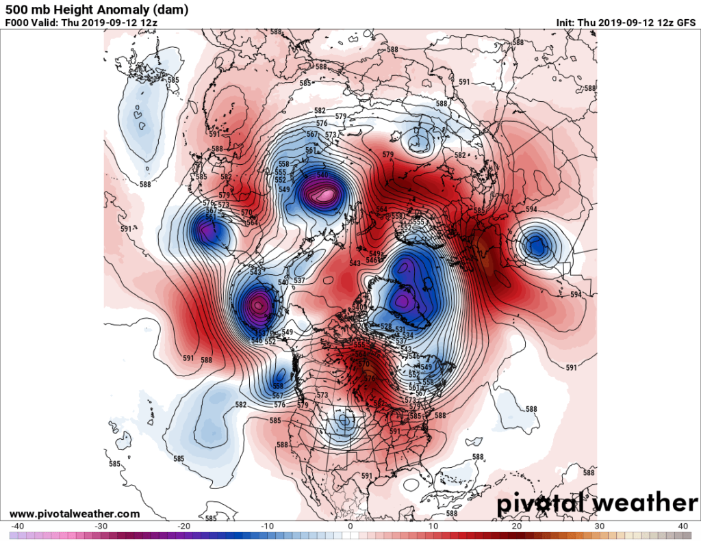
Here is how the heat dome in association with this very late summer heat wave was analyzed this morning with a view elsewhere in the Northern Hemisphere:

Anomalous warmth covers most of the CONUS and extends northward through the North Pole into Asia and across a broad swath of Europe. Notice all of the closed, cold lows milling about the hemisphere. This is a sign of a weakened jet, and is a sign of climate disruption. It’s no wonder that meteorological models are having trouble spitting out good forecasts trying to process what will happen with so many relatively small features. It’s very odd to see how much U.S. territory is covered by 588 + decameter heights as late as Seotember 12th.
So far through September 9th across the United States I did note this statistic:
In my neck of the woods Atlanta tied a daily record high yesterday of 96F and will likely break the old record for the 12th of 94F:
School outdoor activities are having to be curtailed because of the heat around Atlanta.
Also:
Not surprisingly fall fronts are having difficulty moving south and thus are wringing out a lot of moisture…also a sign of climate change:
The hot weather pattern in the Southeast is interacting with the tropics. We have another weak system in the Bahamas, which last night’s European model blew up to be a big hurricane off the East Coast, which was a forecast surprise, last night:
The GFS continues to forecast a far weaker system moving into the Gulf:
Confidence in any model solution is quite low given the factors I pointed out in today’s post. We will see what transpires hoping that any system does not strengthen over the Dorian ravaged Bahamas and remains weak.
Here is more climate and weather news from Thursday:
(As usual, this will be a fluid post in which more information gets added during the day as it crosses my radar, crediting all who have put it on-line. Items will be archived on this site for posterity. In most instances click on the pictures of each tweet to see each article.)
Here are more “ET” reports from the September 11th and 12th:
(If you like these posts and my work please contribute via the PayPal widget, which has recently been added to this site. Thanks in advance for any support.)
Guy Walton- “The Climate Guy”