The main purpose of this ongoing blog will be to track United States extreme or record temperatures related to climate change. Any reports I see of ETs will be listed below the main topic of the day. I’ll refer to extreme or record temperatures as ETs (not extraterrestrials).😉
Main Topic: Early November Record Scoreboard Update And Climatological Review
Dear Diary. We have three big stories we are watching around noon on this Friday. A) We are waiting for Joe Biden to officially be declared U.S. President B) All meteorological eyes are watching ETA as it redevelops and heads towards Cuba and South Florida, and C) COVID19 continues to rage across our country. Before you see many articles I’ve linked to this site on those issues, it’s time once again for our monthly climatological review.
Here on this site we present monthly summaries near the 6th of each month, and each is available if you want to go back through my Extreme Temperature Diary archive. This particular month I’ve added a new category on my site for these posts.
I’m repeating my mantra from last month:
October 2020 got ranked by the National Center for Environmental Information as a near average October, temperature wise, for the lower 48 states, coming in as 67th coolest or 60th warmest since records began being kept in 1895:
https://www.ncdc.noaa.gov/cag/national/rankings
There was an above average number of extreme temperature reports. Most warm records occurred in the southwestern United States in association with a heat wave early in the month. Most cold records were recorded during the third week of the month due to a historic polar outbreak in the Rockies and Plains. It was cold enough for some very rare October all-time cold records to get logged in the NCEI database. The cold outbreak produced more cold reports than the early October heatwave.
Here are my two U.S. Daily Record Scoreboards updated through 11/4/2020 (data compiled from the following NCEI site):
https://www.ncdc.noaa.gov/cdo-web/datatools/records

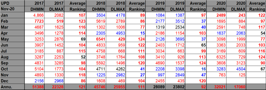
DHMX= Daily High Max Reports. DLMN= Daily Low Min Reports. DHMN= Daily High Min Reports. DLMX=Daily Low Max Reports.
For these data sets all monthly ratios of > 10 to 1 DHMX to DLMN or > 10 to 1 DLMN to DHMX are in bold type. The rankings are for the lower 48 states with the warmest ranking since 1895 of average temperatures being 125 and 1 being the coldest as of 2020. Blue colors represent cold months and red warm. Those months and years with counts close to a 1 to 1 ratio of highs to lows are colored black. Boldly colored months, such as January 2020, have ratios of more than 10 to 1 daily record highs to lows or lows to highs, and are either historically hot or cold, most of which have made news.
October 2020 had approximately a 1-1ratio of record DHMX to DLMN individual record counts, so the color I used for this month was black on the top chart (And was closer than all states in the U.S. election😉).
October 2020 had approximately a 6-9 ratio of record DHMN to DLMX individual record counts, so the color I used for this month was blue on the bottom chart.
Due to climate change we are seeing less blue colors on these Record Scoreboards with time, but October 2020 was an exception to this trend.
As stated, the ranking for October 2020 was 67, which was colored black. I color rankings +10 or -10 from the average ranking of 63 black, indicating that these are near average temperature wise.
We are seeing strong indications that in November 2020 we will see above average temperatures for most U.S. states looking at meteorological guidance. Also, looking at the record scoreboards, November 2020 has started out fairly toasty.
Here is much more detailed U.S. climatology as complied by NOAA:
https://www.ncei.noaa.gov/news/national-climate-202010
Assessing the U.S. Climate in October 2020
Tie for most active Atlantic hurricane season on record; western wildfires continue to set new records

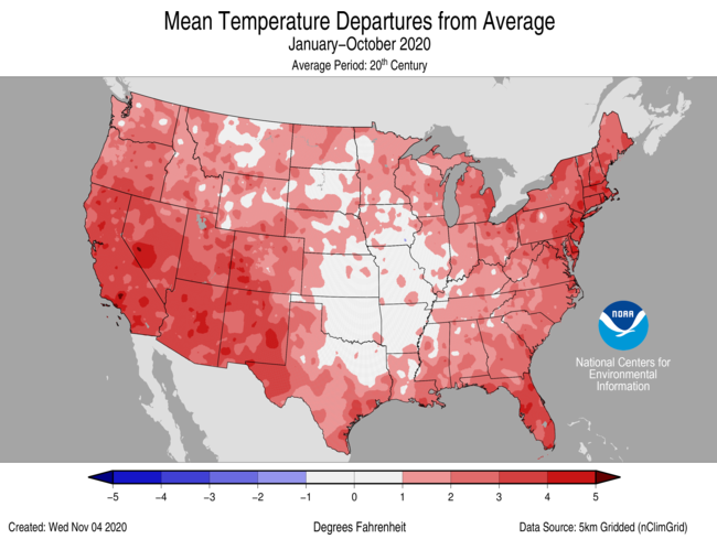
For October, the average contiguous U.S. temperature was 54.4°F, 0.3°F above the 20th-century average. This ranked in the middle third of the 126-year period of record. For the year-to-date, the contiguous U.S. average temperature was 57.0°F, 2.1°F above average, and tied with 2006 for seventh warmest in the historical record.
The October precipitation total for the contiguous U.S. was 2.16 inches, exactly average, and ranked in the middle third of the historical record. For the year-to-date, the contiguous U.S. precipitation total was 26.30 inches, 0.94 inch above average, and ranked in the wettest third of the January-October record.
Above-average tropical activity across the Atlantic Basin continued into October as one tropical storm and three hurricanes developed over the course of the month. With the formation of Tropical Storm Eta on November 1, 28 named storms have formed during 2020, which ties 2005 for the record number of storms in a single season.
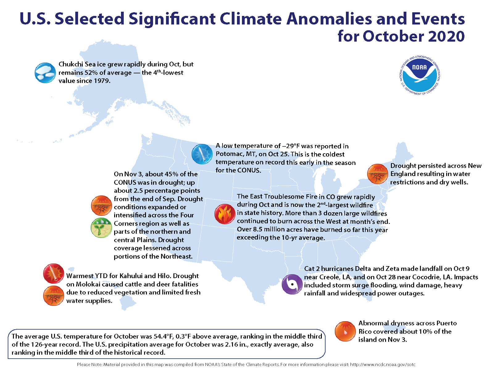
Wildfires across Colorado grew rapidly during October. As of November 1, the three largest fires on record in Colorado occurred in 2020. More than three dozen large wildfires continued to burn across the West at month’s end. Over 8.5 million acres have burned so far this year, which exceeds the ten-year average.
This monthly summary from NOAA National Centers for Environmental Information is part of the suite of climate services NOAA provides to government, business, academia, and the public to support informed decision-making.
October Temperature
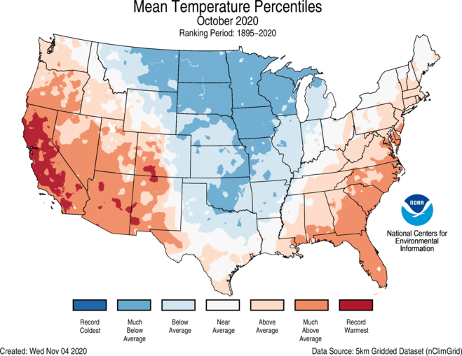
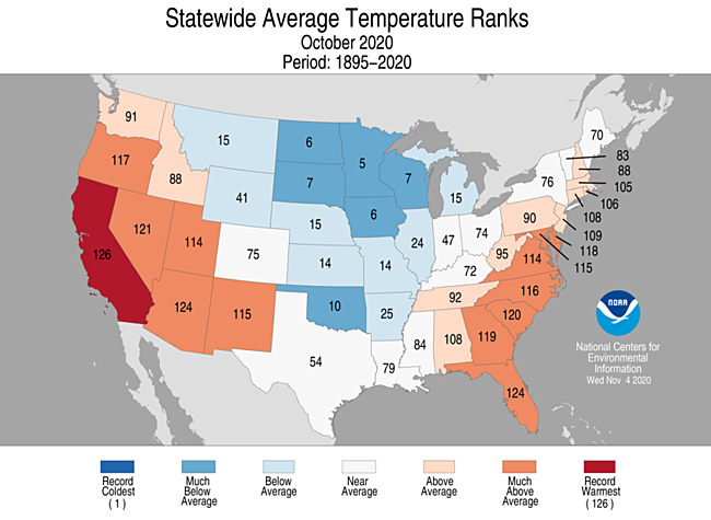
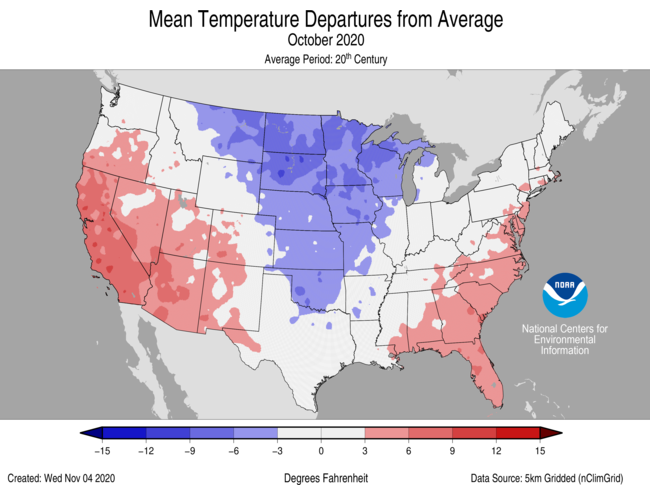
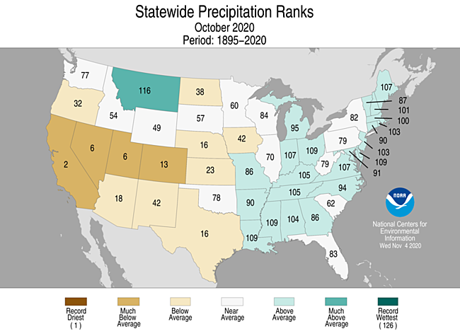
- Above-average temperatures dominated the western U.S., the central Gulf Coast and the East Coast. California ranked warmest on record for October while Arizona and Florida both ranked third warmest.
- Below-average temperatures were observed from the northern Rockies to Great Lakes and southward to the southern Plains. North Dakota, South Dakota, Minnesota, Iowa, Wisconsin and Oklahoma ranked among their 10 coldest Octobers on record.
- A deep trough of low pressure across the West during the last week of the month allowed unseasonably cold temperatures to plunge into portions of the Rockies, northern Plains and Great Lakes. Record to near-record cold temperatures blanketed the U.S. from the central and southern Rockies to the western Great Lakes during the last week of October. A number of records for cold daily high and low temperatures were broken.
- On October 25, Potomac, Montana, reported a low temperature of −29°F — the coldest temperature on record this early in the season for the contiguous U.S.
- Many stations throughout the Rockies reported below-zero temperatures on the early morning of October 26.
- Alaska ranked in the warmest third of the October record with a statewide average temperature of 29.0°F, 3.5°F above the long-term average. A strong northwest to southeast temperature anomaly gradient existed during October with the warmest anomalies across portions of the North Slope and the coolest across the Southeast Interior and the Panhandle. It was the fourth-warmest October for Utqiaġvik (Barrow) and the 19th consecutive such year-to-date period with above normal temperatures.
October Precipitation

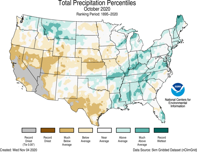
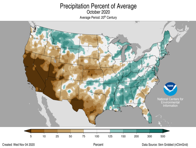
- Below-average precipitation was observed across much of the western U.S., the Deep South, central and northern Plains as well as across portions of the Southeast. California ranked second driest on record for October. Nevada and Utah both ranked sixth-driest October on record.
- Above-average precipitation occurred across portions of the northern Rockies, Great Lakes, middle and lower Mississippi Valley, Ohio Valley, Northeast and parts of the Southeast.
- Record daily and monthly snowfall were reported across portions of the West and Plains during the last week of October.
- It was the snowiest October on record for many stations including Spokane, Washington (7.5 inches); Great Falls, Montana (28.0 inches); Minneapolis-St. Paul (9.3 inches) and St. Cloud, Minnesota (7.2 inches); Albuquerque, New Mexico (4.2 inches); Amarillo, Texas (7.4 inches) and Wichita, Kansas (1.6 inches).
- An ice storm associated with the record cold temperatures impacted parts of the central and southern Plains on October 27. More than 350,000 residents in central and southwestern Oklahoma were without power as freezing rain and ice brought down foliage-filled trees and, subsequently, powerlines. This is the earliest ice storm on record for Oklahoma.
- Across Alaska, October was wet across parts of the North Slope. The Panhandle and Gulf Coast were drier than average for the month.
- According to the November 3 U.S. Drought Monitor report, approximately 45 percent of the contiguous U.S. was in drought, up slightly from 42.6 percent at the end of September. Drought conditions intensified across the Four Corners region as well as parts of the northern and central Plains. Drought coverage became less severe across portions of the Northeast. Drought also expanded across Hawaii.
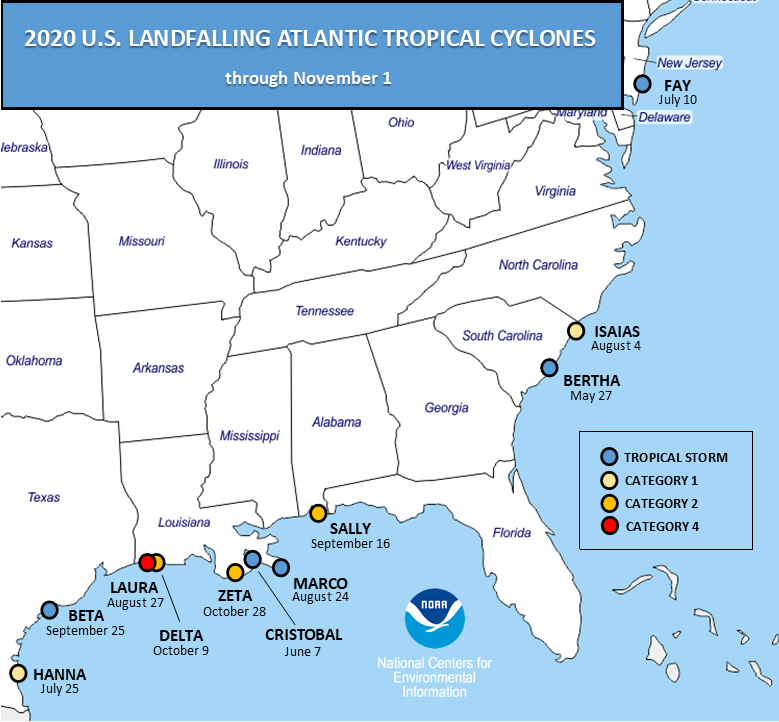
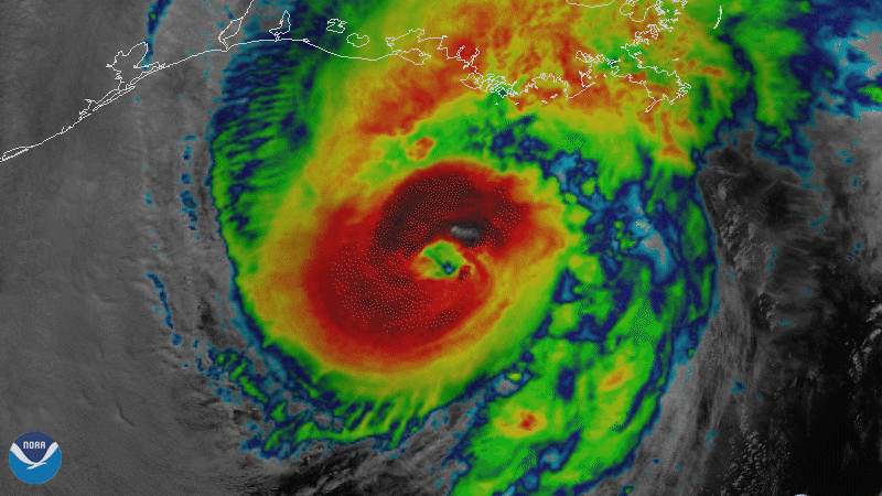
- Eleven named U.S. storm continental landfalls have occurred during the 2020 Atlantic hurricane season through November 1. This breaks the previous record of nine landfalls in 1916.
- Through November 1, six hurricanes made landfall in the U.S., which ties 1985 and 1886 for most hurricane landfalls in a single season.
- Hurricanes Delta and Zeta made landfall along the Louisiana coast during October, bringing the total number of landfalling named storms for Louisiana in 2020 through November 1 to five (Cristobal, Marco, Laura, Delta and Zeta). This is a new record for Louisiana and any U.S. state.
- Category 2 Hurricane Delta came ashore on October 9 at Creole, LA, six weeks after Category 4 Laura and approximately 12 miles east of Laura’s landfall location.
- As of November 3, Delta and Eta are the strongest Greek-named hurricanes in the Atlantic on record with maximum sustained winds of 145 mph, exceeding Beta (2005), which had 115 mph maximum sustained winds.
- Category 2 Hurricane Zeta made landfall near Cocodrie, LA, on October 28, joining Kate (1985) and two unnamed storms (1935, 1899) as the only Category 2 storms on record to make mainland U.S. landfall so late in the Atlantic season.
- More than 2.7 million customers from Louisiana to Virginia were without power on October 28 and 29. Widespread damage resulted from storm surge, high winds and flooding rainfall across much of the region as Zeta moved up the East Coast.
- Despite the record pace and tie for number of named storms in the Atlantic, the 2020 tropical cyclone Accumulated Cyclone Energy (ACE) is just barely in the top quartile, or above 165 percent of the 1981-2010 median value.
- The wildfires across Colorado continue to burn. As of November 1, the East Troublesome Fire is now the state’s second-largest wildfire on record with more than 193,000 acres consumed. In late October, the fire spread rapidly, forcing the evacuation of the entire town of Grand Lake. The 2020 Cameron Peak and Pine Gulch fires are currently the largest and third-largest fires in state history, respectively.
- Near the end of October, wildfire conditions and subsequent activity across California rekindled. Residents in parts of southern California had to evacuate due to dry conditions and strong Santa Ana winds. Nearly 100,000 Orange County residents were forced to evacuate as the Silverado and Blue Ridge fires spread rapidly. Reports of winds in excess of 100 mph were observed along several ridgetop ski resorts on October 25-26. High winds combined with very dry air and fuels created an ideal environment for explosive wildfire activity.
Year-to-date (January–October) Temperature
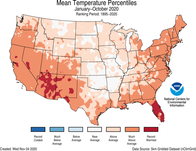
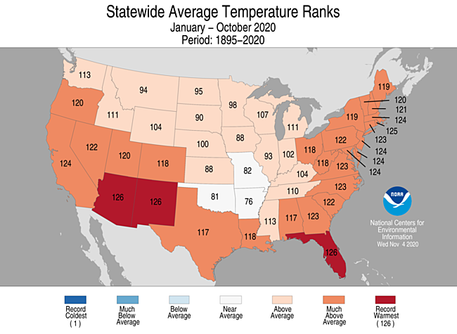
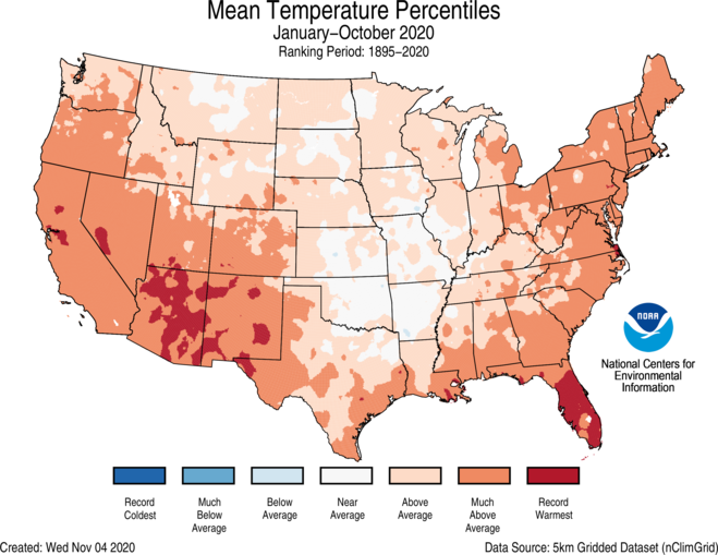
- Above-average year-to-date temperatures were observed across most of the Lower 48. Record warm temperatures were scattered throughout the Southwest and Southeast. Arizona, New Mexico and Florida ranked warmest on record for this 10-month period with six additional states in the West and Northeast ranking among their top-3 warmest January-Octobers on record.
- Near-average temperatures were observed from the northern Rockies to the central Plains. There were no notable regions reporting below-average temperatures for this year-to-date period.
- Temperatures across Alaska ranked in the middle third of the historical record for January-October. Above-average temperatures blanketed much of the West Coast and Aleutians as well as parts of the North Slope. Below-average temperatures were observed in portions of the Northeast and Southeast Interior regions.
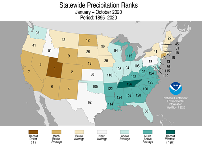
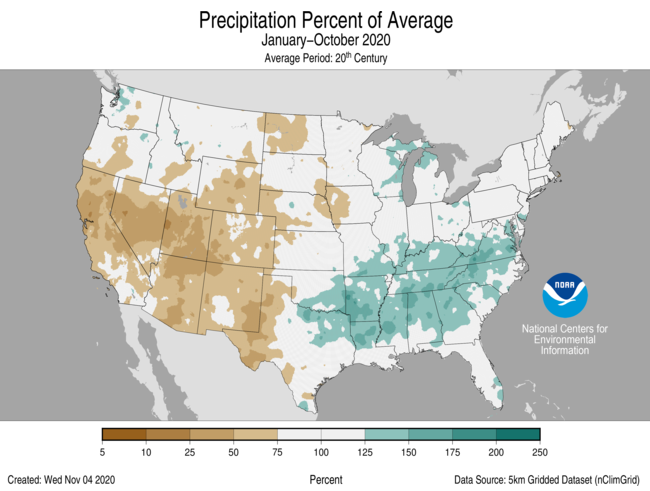
Year-to-date (January–October) Precipitation
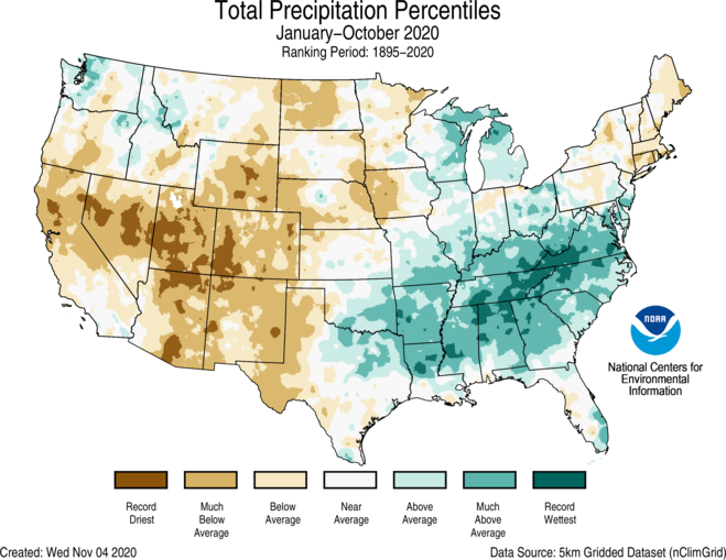
- Above-average January-October precipitation dominated much of the central Gulf Coast, Midwest, Southeast, Great Lakes and parts of the Northwest. Tennessee ranked wettest while North Carolina ranked second wettest for this year-to-date period.
- Below-average year-to-date precipitation occurred across the West, parts of the northern and central Plains as well as the Northeast. Utah ranked driest on record while Colorado ranked second driest.
- Across Alaska, year-to-date precipitation was near average. The Aleutians and Gulf Coast were drier than average while portions of the Interior regions received above-average precipitation for the first 10 months of the year.
Here are some of Thursday and Friday’s “ET” reports:
Here is more climate and weather news from Friday:
(As usual, this will be a fluid post in which more information gets added during the day as it crosses my radar, crediting all who have put it on-line. Items will be archived on this site for posterity. In most instances click on the pictures of each tweet to see each article. The most noteworthy items will be listed first.)
First, some notes on the very important U.S. election for our climate:
Next, some notes on Eta:
And some other items from Friday:
Now here are some of today’s articles and notes on the horrid COVID-19 pandemic:
(If you like these posts and my work please contribute via the PayPal widget, which has recently been added to this site. Thanks in advance for any support.)
Guy Walton “The Climate Guy”