The main purpose of this ongoing blog will be to track planetary extreme or record temperatures related to climate change. Any reports I see of ETs will be listed below the main topic of the day. I’ll refer to extreme or record temperatures as ETs (not extraterrestrials).😉
Main Topic: Update on CAT4 Heatwave British Petroleum
Dear Diary. Today’s diary entry will be on another amazingly hot event occurring across the United States and this time Mexico. Heatwave British Petroleum is the second heatwave named after a fossil fuel corporation for this year:
(Pardon me for the misspelling of petroleum. I don’t like it, so I can’t spell it.😉)
As many of you reading my posts know, I started naming heatwaves after fossil fuel companies as a dig against corporations who are carbon polluters and as a red flag for the public.
The first, dubbed Heatwave Amoco, occurred earlier in May and June, which was also a CAT4 system and affected millions of people from the Pacific Northwest into Canada, our northern neighbor that is having its worst fire season in recorded history. Thick smoke from those fires chocked cities across the northern tier of states for days:
Here is my list of heatwaves for this year:

Why were heatwaves Amoco and British Petroleum pegged in the historic CAT4 category? Because both will be blamed for hundreds of deaths. Amoco may have had more deaths from choking smoke.
Here is a good summary from the Washington Post on Heatwave British Petroleum, so far as of 6/21/23:
The troubling heat in Texas and its ties to climate change in 5 maps – The Washington Post
The troubling heat in Texas and its ties to climate change in 5 maps

By Dan Stillman
Updated June 21, 2023 at 12:33 p.m. EDT|Published June 20, 2023 at 3:20 p.m. EDT

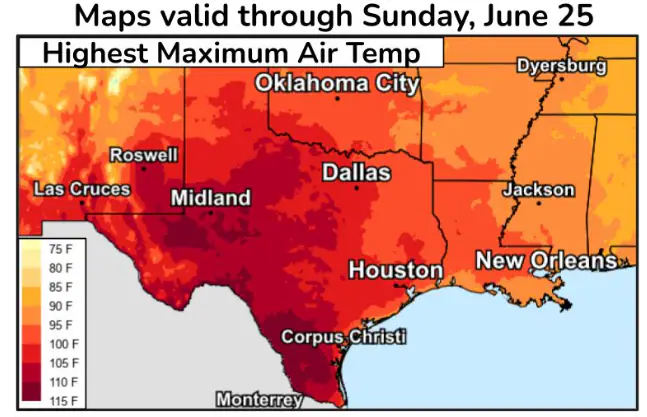
Predicted maximum temperatures in Texas through June 25. (National Weather Service)
Texas is no stranger to searing heat, but the heat wave that arrived last week is becoming exceptional for its intensity and duration. Air temperatures have soared past 100 degrees for multiple days, even exceeding 110 in spots, and the sizzling heat index has reached as high as 125. Excessive-heat warnings are in effect into the middle of the week for a massive chunk of the state and could be extended.
San Angelo set an all-time record high Tuesday with a temperature of 114 degrees, beating the previous mark by 3 degrees. Del Rio, to the west, also set an all-time high, reaching 113 degrees. That came after Laredo reached 115 degrees on Monday, tying its highest temperature on record. In Houston, the temperature reached 100 degrees on Monday for the first time this year, a month earlier than the average first 100-degree day.
The heat is also brutal in Mexico, where the northern cities of Monclova and Chihuahua set all-time record highs of 115 and 107 degrees, respectively, on Tuesday, according to weather historian Maximiliano Herrera.
This prolonged heat wave will wax and wane some in the coming days but shows no sign of completely going away.
“Repeated and lengthy exposure to heat can increase the risk of health impacts,” the National Weather Service cautioned. “The core of the heat may focus more over southern and western Texas late this week, before expanding again next weekend into the following week.”
Texas law overrides safeguards like water breaks as temperatures rise
The scientific literature is replete with studies connecting the intensity, frequency, duration and size of heat waves such as this to human-caused climate change.
Here are five maps to put the historic Texas heat wave in perspective.
Triple-digit temperatures all over Texas

Wednesday high temperatures predicted by the National Weather Service. (WeatherBell.com)
The air temperature alone, not taking into account the humidity, will remain scorching across most of Texas on Wednesday.
Temperatures reached near or beyond 100 degrees Tuesday everywhere except the far-northeast corner of the state, where highs mostly topped out in the mid- to upper 90s. Temperatures in central and southern portions of the state surged as high as 105 to 115 degrees, which is 15 to 20 degrees above normal.
Temperatures may cool off a few degrees in Central Texas on Wednesday, but it’s another day with highs around 105 to 112 in southern and southwestern parts of the Lone Star State.
Punishing heat indexes, with little relief at night

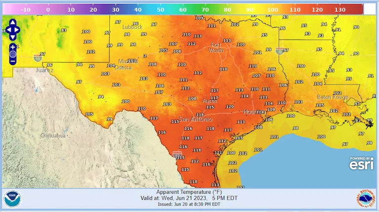
The Wednesday afternoon heat index predicted by the National Weather Service. (NOAA)
A large swath of South and East Texas saw the heat index climb to about 110 to 120 degrees Tuesday and similar conditions are expected Wednesday. The heat index, which takes into account both the temperature and the humidity, is a better indicator than temperature alone of how hot the air feels. The higher the humidity, the hotter it feels, because it limits your body’s ability to cool off through sweating.
Even on Tuesday night, the heat index was expected to stay up in the 80s across most of the state. Hot nights makes heat waves especially dangerous. “The lack of overnight cooling and recovery, with daily record warm minimum temperatures possible, will compound the effects of the heat wave,” the Weather Service said.
Last week, the heat index reached a blistering 125 degrees in Kingsville. Meanwhile, Dallas matched its highest dew point on record at 80 degrees, which helped drive its heat index up to near 110. Dew point is a measure of humidity, and any value over 70 degrees is considered extremely humid.
A historically intense heat dome
Extreme and extended heat waves like the one now happening in Texas are often caused by heat domes such as the one pictured above. These large, sprawling zones of high pressure cause air to sink underneath them. The air warms as it sinks and the heat dome traps the hot air in place.
The heat dome responsible for the ongoing Texas heat wave is one of the strongest of all time and, according to WFLA-TV chief meteorologist and climate specialist Jeff Berardelli, is “basically impossible” without climate change.
This heat dome follows another unusually intense one that sparked a historic heat wave across Puerto Rico and the Caribbean in early June. Another strong heat dome, in central Canada, has helped fuel one of that country’s worst-ever starts to the fire season, sending plumes of toxic smoke pollution into the United States.
Heat domes are not uncommon for the United States during the summer, but typically they are centered over the Plains, whereas this summer an unusual jet stream pattern has pushed the placement further south.
How Texas’s climate has already shifted

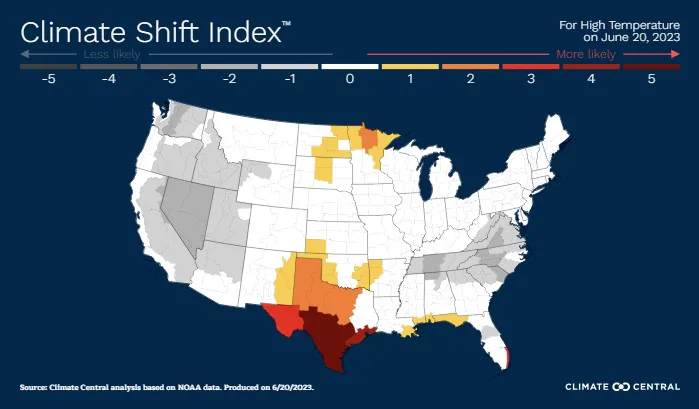
Climate Central’s climate shift index for Tuesday. (Climate Central)
Climate change has already increased the odds of seeing longer and more frequent intense heat waves. How likely would the Texas heat be without climate change?
Climate Central, a nonprofit science communication organization based in Princeton, N.J., attempts to answer that question with its Climate Shift Index, which estimates the influence of climate change on extreme temperatures around the world.
For predicted high temperatures on Tuesday, the 0-to-5 index registers at levels 3, 4 and 5 across the southern half of Texas. Those levels translate to climate change making the extreme heat at least three, four and five times as likely. Climate Central describes level 4 conditions as “extremely rare without climate change” and level 5 as “an exceptional event driven by climate change.”
How Texas climate might shift further in the future

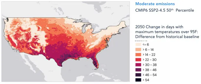
Expected change by 2050 in the number of days per year with maximum temperatures over 95 degrees compared with the historical average. (ICF Climate Center)
The Climate Center of ICF, a global advisory and technology services company, used new climate models to project how much hotter the United States will get by 2050 under different greenhouse gas emissions scenarios. Even under a moderate emissions scenario, which many climate scientists now say is more realistic than higher scenarios, Texas could see 30 to 50 more days with the temperature over 95 degrees by 2050.
The analysis shows “potentially even hotter than previously appreciated with standard data sets used by most planners,” ICF climate scientist Mason Fried said in an email. “The exact outcomes will vary based on the level greenhouse gas emissions are reduced in the coming years.”

By Dan Stillman Dan Stillman is a meteorologist and editor for the Capital Weather Gang. He earned an M.S. in Meteorology from Texas A&M University, and a B.S. in Atmospheric, Oceanic and Space Sciences from the University of Michigan. Twitter
Much More:
Here are some other “ET’s” recorded from around the planet the last couple of days, their consequences, and some extreme temperature outlooks, as well as any extreme precipitation reports:
Here is more climate and weather news from Tuesday:
(As usual, this will be a fluid post in which more information gets added during the day as it crosses my radar, crediting all who have put it on-line. Items will be archived on this site for posterity. In most instances click on the pictures of each tweet to see each article. The most noteworthy items will be listed first.)