The main purpose of this ongoing blog will be to track planetary extreme, or record temperatures related to climate change. Any reports I see of ETs will be listed below the main topic of the day. I’ll refer to extreme or record temperatures as ETs (not extraterrestrials).😉
Early Cape Verde Tropical Systems a Good Sign of Climate Change
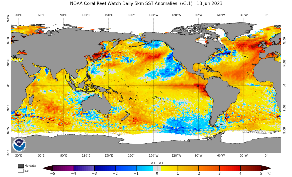
Dear Diary. Over the past several days I’ve posted many an article on the Atlantic Basin’s record warmth. Here is one such note:
The southern part of the Atlantic Basin is very warm also:

That has led to a system that will likely be named Bret soon:

It’s time for us to revisit my post on “oddly” forming tropical systems:
Here are attributable climate change factors researchers are looking with any tropical cyclone:
1) Record strength per relatively high latitude
2) Record or near record low pressure and corresponding record high sustained wind speed (Wilma from 2005 holds that record over the Atlantic Basin at 882 millibars.)
3) Longevity of maintaining a relatively high wind speed. (Irma set some records for this over the central Atlantic in 2017.)
4) Record rainfall after landfall (Harvey set many records for totals in 2017.)
5) Stalling, becoming trapped underneath a warm ridge either before or after landfall. (Harvey was the poster child for this effect.)
6) Record or near record rapid intensification
7) Record late or early season tropical cyclones for any given ocean basin
8) Record length of time a tropical system is able to maintain depression status or higher once moving inland
9) Forming over “odd” locations of an ocean basin not traditionally seeing tropical development
10) Seeing numerous simultaneous systems over the world’s oceans
Bret will be pegged for number nine on my list.
Here are many more details from Dr. Jeff Masters and Yale Climate Communications:
TD 3: a rare June hurricane threat for the Caribbean » Yale Climate Connections
TD 3: a rare June hurricane threat for the Caribbean
The system is predicted to intensify and threaten the Lesser Antilles Islands as Hurricane Bret by Thursday.


by JEFF MASTERS and BOB HENSON JUNE 19, 2023

Visible satellite image of the eastern tropical Atlantic at 11 a.m. EDT June 19, 2023. (Image credit: NOAA/RAMMB/Colorado State University)
The calendar says it’s mid-June. The phase of the El Niño/Southern Oscillation (ENSO) reads El Niño. But despite these usually highly unfavorable factors for Atlantic hurricane activity, the tropical Atlantic is looking more like mid-August, thanks to sea surface temperatures that are record-warm — plus an unusual lack of wind shear. Not only do we have newly-formed Tropical Depression Three, but another tropical wave off the coast of Africa, 93L, has a 40% chance of development.
Track forecast for TD 3
Tropical Depression Three (TD 3) formed at 11 a.m. EDT Monday in a location where just seven other June tropical cyclones have been known to form: the central tropical Atlantic’s main development region (MDR), between the Lesser Antilles Islands and the coast of Africa. At 11 a.m. EDT Monday, TD 3 was headed west at 21 mph with a central pressure of 1009 mb and top sustained winds of 35 mph.
Steering currents favor a westward motion over the next three days, with a turn to the west-northwest as the system approaches the Lesser Antilles on Thursday. This turn more to the northwest will depend critically upon how quickly TD 3 intensifies; a stronger storm will “feel” steering currents that will tend to pull the storm more to the northwest. The timing of when TD 3 would pass through the islands is also uncertain; the European model and its ensembles predict this will occur on Thursday, while the GFS model and its ensembles have a slower-moving storm that would not arrive until Friday. These factors make the track forecast more uncertain than usual; in their initial forecast for TD 3, the National Hurricane Center emphasized: “This should be considered a low confidence track forecast…since this forecast situation can result in large errors.”

Figure 1. Track forecasts out to 10 days for TD 3 from the 0Z Monday, June 19, run of the European ensemble model. Individual forecasts of the 51 ensemble members are the lines color-coded by the wind speed in knots they predict for TD 3; red colors correspond to a category 1 hurricane. The time in hours from the model initialization time are in grey text. The black line is the ensemble mean forecast. The ensemble members generally predicted a tropical storm that would pass through the Lesser Antilles Islands between 72-96 hours from initialization time (around Thursday, June 22). Upon entering the eastern Caribbean, the system was predicted to weaken to a tropical depression and dissipate. (Image credit: weathernerds.org)

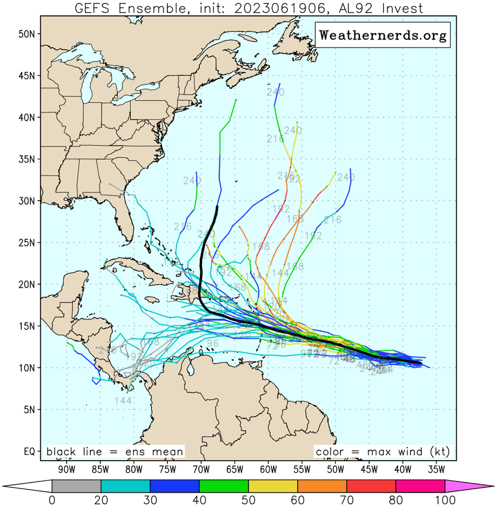
Figure 2. Track forecasts out to 10 days for TD 3 from the 6Z Monday, June 19, run of the GFS ensemble model. Individual forecasts of the 31 ensemble members are the lines color-coded by the wind speed in knots they predict for TD 3; red colors correspond to a category 1 hurricane. The time in hours from the model initialization time are in grey text. The black line is the ensemble mean forecast. The ensemble members were generally slower than their counterparts from the European model predicting a system that would pass through the Lesser Antilles Islands between 96-120 hours from initialization time (around Friday, June 23). Upon entering the eastern Caribbean, the system was predicted to weaken. (Image credit: weathernerds.org)
Intensity forecast for TD 3
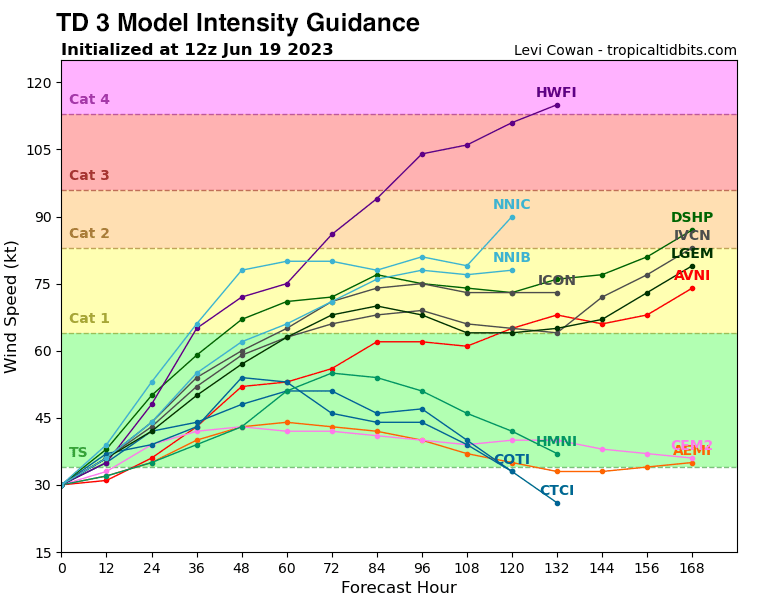
Conditions are expected to be favorable for development for TD 3 through Wednesday night, with light wind shear of 5-10 knots, a moist atmosphere, and record-warm sea surface temperatures near 28 degrees Celsius (82°F). However, as the system approaches the Lesser Antilles Islands, an upper-level trough will bring higher wind shear, and the storm will encounter dryer air. These factors should slow development or cause weakening. The intensity models show a wide range of possible intensities for TD 3 when it arrives in the islands, ranging from a weak tropical storm to a category 3 hurricane (Figure 3).

Figure 3. Intensity forecasts available at 8 a.m. EDT (12Z) Monday, June 19, for TD 3. (Image credit: Tropical Tidbits)
The next name on the Atlantic list of storms is Bret. If Bret does form, it will be the third Atlantic storm of the year, following the formation of Tropical Storm Arlene on June 2 and an unnamed subtropical storm on January 16. The typical formation date of the season’s third storm is Aug. 3. The record-earliest formation date of the season’s third named storm came on June 2, 2020, when Tropical Storm Cristobal formed. That year had a record 30 named storms, and holds 26 of the 30 earliest formation date records.
Tropical wave 93L off the coast of Africa has support for development
A tropical wave that emerged from the coast of Africa over the weekend was located a few hundred miles south-southwest of the Cabo Verde Islands on Monday morning. This wave, designated 93L by the National Hurricane Center, was headed west at 10-15 mph. Conditions are expected to be favorable for development over the next three days, with light to moderate wind shear of 5-15 knots, a moist atmosphere, and record-warm sea surface temperatures near 28 degrees Celsius (82°F). This system has support for development by late this week from a number of members of the Monday morning runs of the GFS and European model ensembles, as well as the 6Z and 12Z Monday operational versions of the GFS model.
In their 8 a.m. EDT Monday Tropical Weather Outlook, the National Hurricane Center gave 93L 2-day and 7-day odds of development of 30% and 40%, respectively. The next name on the Atlantic list of storms after Bret is Cindy. The typical formation date of the season’s fourth storm is Aug. 15. The record-earliest formation date of the season’s fourth named storm is June 20, 2016, when Tropical Storm Danielle formed.
How unusual are this week’s two systems for June?
The month of June is typically the least active of the six-month Atlantic hurricane season, coming in just behind November. But the month has produced more than 80 named storms in NOAA data extending back to 1851, and if conditions are right, it’s certainly possible to have a historic hurricane in June. The most notorious example is the month’s strongest on record: Hurricane Audrey. Audrey formed in the western Gulf of Mexico on June 25, 1957, headed northward, and intensified to category 3 strength just before slamming into southwest Louisiana on June 27, catching many unaware and killing more than 400 people.
What makes TD 3 and 93L so exceptional as June systems is their location. In recent decades, only three tropical storms have formed in the Main Development Region between the Lesser Antilles and Africa: Ana (1979), Bret (2017), and Elsa (2021). Elsa was the only one of the three to reach hurricane strength, but it developed on June 30 and did not become a hurricane until July 2.
The most ominous analog for a June hurricane in the Main Development Region is the 1933 Trinidad hurricane, which became a tropical depression on June 24 and struck Trinidad as a category 1 hurricane on June 27. The hurricane continued west across the Caribbean, through the Yucatan Channel, and into the Gulf of Mexico before making its final landfall in Mexico on July 8. No other named storm to date has formed so far east so early in the year. The hurricane destroyed hundreds of homes and killed at least 35 people along its track. The 1933 Trinidad hurricane also kicked off the hyperactive season of 1933, one of the worst in Atlantic history, with 20 named storms, 11 hurricanes, 6 major hurricanes, and an all-time record for accumulated cyclone energy (ACE) of 259.
Website visitors can comment on “Eye on the Storm” posts (see comments policy below). Sign up to receive notices of new postings here.

Jeff Masters, Ph.D., worked as a hurricane scientist with the NOAA Hurricane Hunters from 1986-1990. After a near-fatal flight into category 5 Hurricane Hugo, he left the Hurricane Hunters to pursue a… More by Jeff Masters

Bob Henson is a meteorologist and journalist based in Boulder, Colorado. He has written on weather and climate for the National Center for Atmospheric Research, Weather Underground, and many freelance… More by Bob Henson
Dr. Jeff Master’s and Bob Henson’s TD 3: a rare June hurricane threat for the Caribbean was first published on Yale Climate Connections, a program of the Yale School of the Environment, available at: http://yaleclimateconnections.org. This work is licensed under a Creative Commons Attribution-Noncommercial-No Derivative Works 2.5 license (CC BY-NC-ND 2.5).
Much More:
Here are some “ET’s” recorded from around the planet the last couple of days, their consequences, and some extreme temperature outlooks, as well as any extreme precipitation reports:
Here is more climate and weather news from Monday:
(As usual, this will be a fluid post in which more information gets added during the day as it crosses my radar, crediting all who have put it on-line. Items will be archived on this site for posterity. In most instances click on the pictures of each tweet to see each article. The most noteworthy items will be listed first.)