The main purpose of this ongoing blog will be to track planetary extreme, or record temperatures related to climate change. Any reports I see of ETs will be listed below the main topic of the day. I’ll refer to extreme or record temperatures as ETs (not extraterrestrials).😉
Main Topic: The Rise of Heatwave Hess That Will Roast the U.S. This Week
Dear Diary. We just can’t shake these during the middle of a climate changed summer. Historic Heatwave Gasprom, which roasted the West, setting over 90 all-time record maxes by my count, and causing California’s Creek Fire to explode, just ended since its heat dome collapsed. We should be getting at least a week of respite, right? Wrong. Already a new heat dome is building over the Plains:
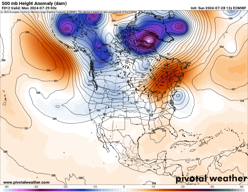
The thing will become massive, leading to a new name from my list of fossil fuel companies for a system that attains my major CAT3 ranking. This heatwave will be named Hess:

My criteria can be found here:
Hess should be named by Monday or Tuesday and should dominate the U.S. weather picture through early August. Already we have a CAT2 heatwave over portions of the Plains and South, which has grown rapidly on this Sunday:
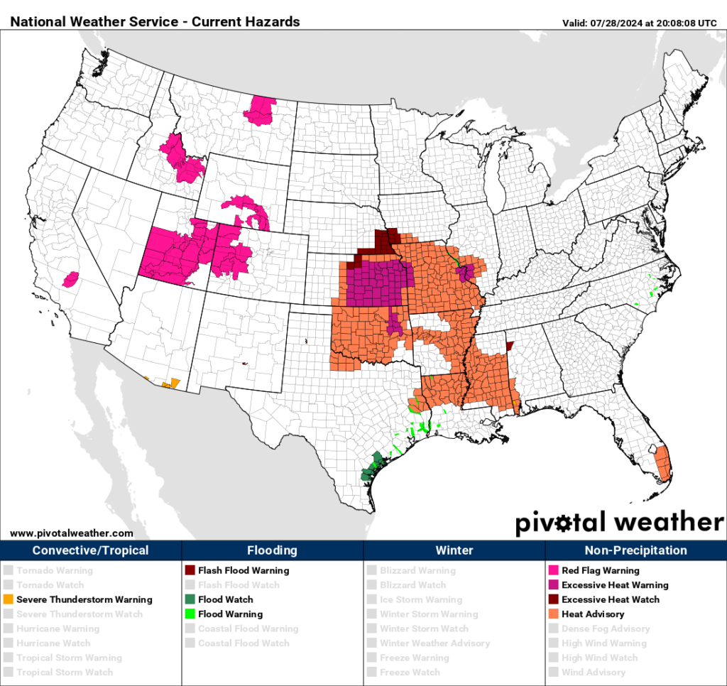
Heatwave Hess will be most intense across the West yet again like most heatwaves from this year, but it will produce well above average temperatures for nearly the entire country:

Here are more details from the Washington Post:
Another major heat wave will build across the United States next week – The Washington Post
Another major heat wave will build across the United States next week
The heat will cause drought to expand while also increasing the fire risk in the western states.
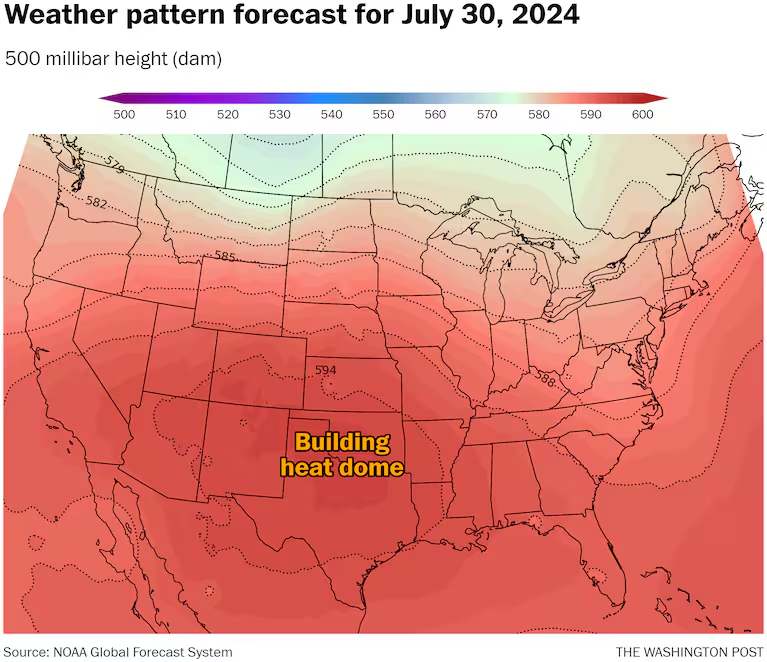
A heat dome is forecast to expand across the United States starting this weekend. (Ian Livingston)

July 26, 2024 at 1:27 p.m. EDT
Friday is a rare day this summer without widespread record-breaking heat in the United States. But this hiatus won’t last long, as the next round of excessive heat is already on the horizon and will probably extend deep into August. The heat will cause drought to expand while also increasing the fire risk in the western states, where numerous large and dangerous blazes are active.
A sprawling heat dome — or zone of intense high pressure — is forecast to become reestablished over the southern United States this weekend, affecting many of the same regions that have already endured punishing temperatures this summer.
The National Weather Service says the upcoming weather pattern supports above-normal temperatures over “almost all” of the Lower 48 states.
The heat will first spread over the central and southern Plains, with highs soaring well past 100 on Sunday and Monday. By the start of August, high temperatures in the 90s or greater will extend from coast to coast.
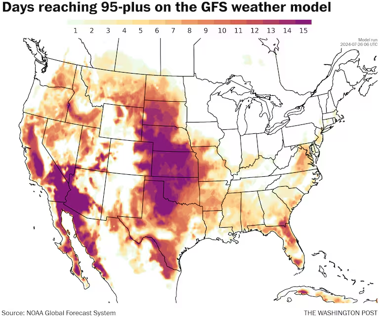
Number of days forecast to reach or exceed 95 degrees during the next two weeks. (Ian Livingston)
The Weather Service’s 0 to 4 HeatRisk scale shows large parts of the nation reaching at least Level 2 and 3 — moderate and major — by the middle of the next week. A number of locations in the central states, including Amarillo, Tex., Wichita and Kansas City, Mo., are forecast to reach Level 4, or extreme.
Heat builds Sunday and Monday
The heat is expected to return to portions of the central and southern United States by late this weekend and early next week
The central Plains should brace for the “most persistent and extreme” heat, according to the Weather Service. High temperatures there, well into the triple digits, will be 10 to 15 degrees above normal.
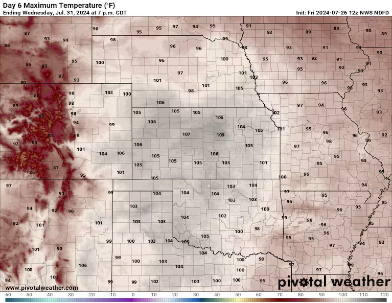
Temperature forecast for next Wednesday from the Weather Service. (Pivotal Weather)
Multiple days of record-challenging highs from 105 to 110 are expected in the Texas Panhandle, parts of Oklahoma and Kansas; highs could even surpass 110 in parts of Kansas by the middle of the week.
Some of the heat will expand into eastern Colorado and New Mexico. Denver could also see highs approaching 100 early next week.
And the heat wave is projected to be prolonged. There is potential for at least five days with highs of at least 100 to 105 in the southern and central Plains.
A scorching start to August
By the second half of next week, when August begins, the Weather Service projects much of the country will be hotter than normal, except perhaps parts of the Southeast, Gulf Coast and parts of the West Coast, where temperatures will be near average.
The southern and central Plains are predicted to remain at the epicenter of the heat wave.
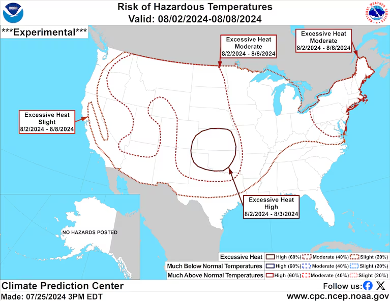
The heat’s intensity may be most prolonged in the western states. By the second week of August, computer models project a powerful heat dome anchored over the region. Underneath it, drought will intensify and expand, and the fire risk may escalate. In Oregon, where many of the largest U.S. fires are burning, the ongoing drought will probably worsen, with little rain in sight.
The Weather Service favors above-average temperatures for much of the nation during August, with the highest odds in the Mountain West and Appalachians. The projected heat in August will almost certainly propel many locations to their hottest summer on record.
How hot it’s already been
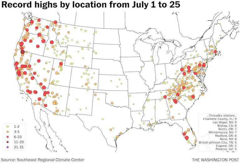
Record highs by location so far in July. (Ian Livingston)
The potentially steamy August follows a brutally hot July in which hundreds of heat records have been set.
In recent days, record highs have been numerous from the northern Rockies to the northern Plains. Locations in Montana and the Dakotas just witnessed their hottest temperatures of the year.
Wednesday saw highs near 110 as far north as the Canadian border. Records included 107 in Havre, Mont., and Williston, N.D. Temperatures in Salt Lake City reached 105, and Boise, Idaho, hit 107.
Thursday’s record high footprint was somewhat smaller as a cold front pushed east, but Williston soared to 109, Rapid City, S.D., reached 105, and Casper, Wyo., hit 100.
The cold front that fanned massive blazes from Alberta, Canada, to Northern California is briefly pushing the heat away.
But, as the Earth is experiencing its hottest days on record, the heat — intensified by human-caused climate change — is poised to reload.

By Ian Livingston Ian Livingston is a forecaster/photographer and information lead for the Capital Weather Gang. By day, Ian is a defense and national security researcher at a D.C. think tank. Twitter
Here are more “ETs” recorded from around the planet the last couple of days, their consequences, and some extreme temperature outlooks, as well as any extreme precipitation reports:
Here is More Climate News from Sunday:
(As usual, this will be a fluid post in which more information gets added during the day as it crosses my radar, crediting all who have put it on-line. Items will be archived on this site for posterity. In most instances click on the pictures of each tweet to see each article. The most noteworthy items will be listed first.)