The main purpose of this ongoing blog will be to track planetary extreme, or record temperatures related to climate change. Any reports I see of ETs will be listed below the main topic of the day. I’ll refer to extreme or record temperatures as ETs (not extraterrestrials).😉
Main Topic: Forecast Big Severe Weather Outbreak Spurred by Record Warmth
Dear Diary. Spring has already sprung across the country and very early for most U.S. residents. One sign that climate change is occurring is that winter, or the time when there is typical cold weather, is getting shorter with spring coming earlier in March. Indeed, what we are witnessing this March of 2025 is another instance of a climate changing early spring.
Just look at these midafternoon Friday temperatures:
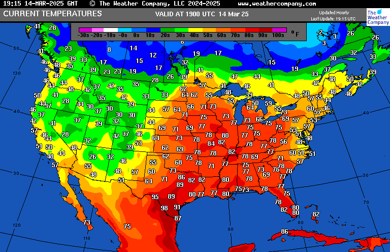
These are at record levels across portions of the Midwest where severe tornadic weather is breaking out as I write this post. It’s above 70°F at Minneapolis where snow is typically in the forecast during mid-March.
Current weather is very far removed from that of mid-March 1993 when ‘The Storm of the Century’ produced blizzard conditions as far south as my hometown of Atlanta. The storm was a big outlier, but due to climate change a similar system would be nearly impossible now in the 2020s:
There will be strong storms developing along a front that will be interacting with this record warmth, so we can state that this coming severe weather outbreak is climate change related.
Here are more severe weather details from the Washington Post:
https://www.washingtonpost.com/weather/2025/03/14/severe-weather-outbreak-tornado-wildfire-forecast
Severe weather expected across central, eastern U.S. through weekend
Strong tornadoes and wildfires possible as a massive three-day severe weather outbreak begins Friday.
March 14, 2025 at 12:08 p.m. EDT
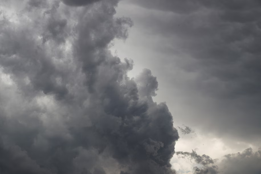
A thunderstorm develops in Portales, New Mexico. (Drew Angerer/Getty Images)
By Matthew Cappucci and Ben Noll
The central and eastern United States are facing an outbreak of severe weather that could last until Sunday, including the potential for strong tornadoes, hail and dangerous winds gusting 60 to 80 mph.
Dangerous conditions will peak Saturday, with one of the most prolific tornado-producing setups in years expected to develop over the Deep South — with disastrous results likely.
The National Weather Service Storm Prediction Center has issued a Level 4 out of 5 risk for both days in some areas. The Friday risk zone includes parts of the Corn Belt and mid-Mississippi Valley, while Saturday’s blankets Mississippi, western Alabama and northeast Louisiana.
On Saturday, it’s probable that the National Weather Service will update to a top-tier and rare high (Level 5 out of 5) risk, driven by the likelihood of intense, long-track tornadoes. It will be the first high risk rating since May 6, 2024. High risks are issued on less than 1 percent of all occasions. Since 2000, there have only been 68 days that were deemed high risk.
The same storm system is also driving high fire risk in the High Plains and southern Plains on Friday, the Storm Prediction Center warned.
“A wildfire outbreak appears likely today across the southern Plains as extremely critical fire weather conditions spread,” the agency wrote.
Meanwhile, winter storm watches are in effect in eastern parts of the Dakotas and western Minnesota, where the system’s cold side will drop a plowable snow.
Here’s where dangerous weather could hit in the next few days:
Friday
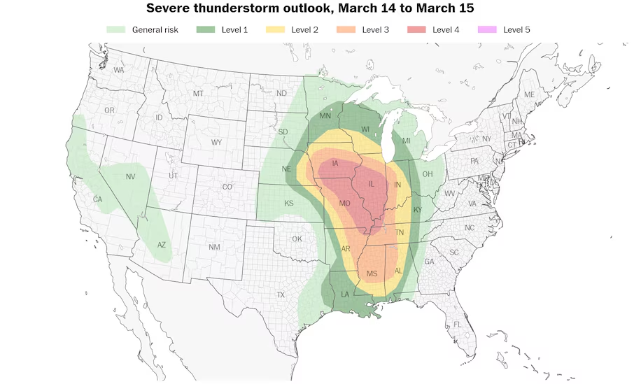
A level 4 out of 5 (moderate) risk for severe thunderstorms covers parts of Iowa, Illinois, western Indiana, Missouri, western Kentucky, northwestern Tennessee and northeastern Arkansas on Friday. (Ben Noll/Data source: NOAA/SPC)
Areas: A moderate (Level 4 out of 5) risk has been issued for parts of the Mississippi Valley from southeast Iowa to Memphis. Cities including St. Louis, Paducah, Kentucky and Memphis are in the core of the greatest tornado risk, with Des Moines and Springfield, Illinois, facing the risk of straight-line winds topping 70 mph. A broader enhanced (Level 3 out of 5) risk extends from Omaha to central Mississippi and western Alabama. Chicago and Nashville have a slight (Level 2 out of 5) risk.
Setup: A bowling ball of low pressure was present over the New Mexico/Colorado border early Friday. It will have a negative tilt, meaning the disturbance will be shaped like a backslash — giving the system more kick, and leading to more severe weather.
Ahead of the low-pressure system, warm, humid air is wafting north from the Gulf of Mexico, providing ample fuel for storms. The low pressure is also dragging a cold front east, which will be the trigger for severe weather.
And with ferocious jet stream wind energy aloft, storms will be able to mix momentum to the surface in the form of destructive gusts. Tornadoes will be common too.
There will be two zones of severe weather.
Northern zone: A squall line will form in eastern Missouri and central Iowa during the midafternoon hours. It will contain damaging gusts of 60 to 80 mph. By sunset, it will begin producing quick-hitting tornadoes. The line will move swiftly east into Illinois before gradually dissipating as it enters Indiana.
Southern zone: Farther south, the environment over eastern Arkansas, northern and central Mississippi and northwest Alabama will be supportive of strong tornadoes if thunderstorms can form. Since the main weather system is passing to the north, there will be less forcing, or less of a trigger, for storms to form. That means there will be fewer storms — but those that do form will tap into an environment ripe for dangerous rotating supercells. A few significant tornadoes are possible overnight. Memphis has seen its severe weather risk increase.
If you are in the zone affected, have a way to be notified of overnight weather warnings — and prepare a shelter plan.
Saturday
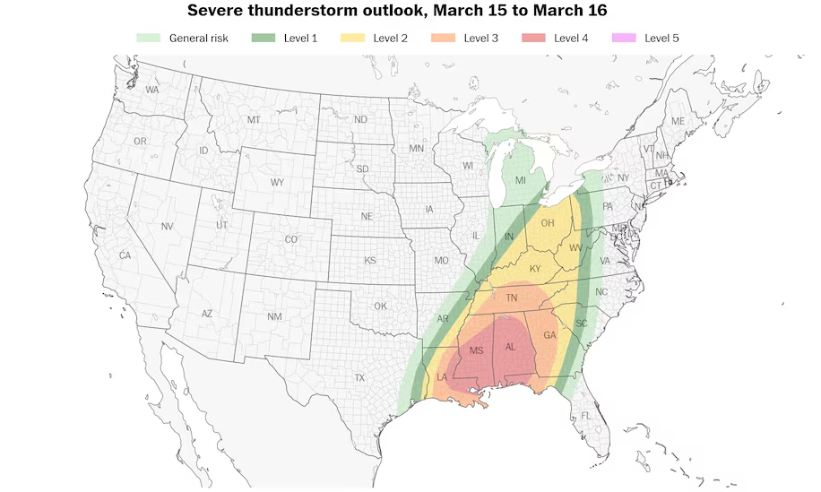
A level 4 out of 5 (moderate) risk for severe thunderstorms covers Louisiana, Mississippi, Alabama and the Florida Panhandle on Saturday. (Ben Noll/Data source: NOAA/SPC)
Areas: A moderate (Level 4 out of 5) risk has been drawn for parts of greater New Orleans, as well as southern and central Mississippi, and western, southern and central Alabama. Included in the zone are Tuscaloosa, Birmingham and Montgomery in Alabama, and Meridian, Jackson and Hattiesburg in Mississippi. An enhanced (Level 3 out of 5) risk also covers Mobile, Alabama, Nashville and Atlanta.
It’s likely that a high (Level 5 out of 5) risk — reserved for only the most extreme events — will be drawn across Mississippi and west central Alabama on Saturday. It will probably encompass the Interstate 59-20 corridor.
Setup: Low pressure will swing a cold front east. Robust gulf moisture will be in place ahead of the cold front, providing ample instability, or thunderstorm fuel. Winds at the surface will be out of the south or south-southeast, but at 10,000 feet, winds will be roaring out of the southwest at very swift speeds. That means any storms that grow tall enough will be affected by those changing winds with height and will rotate. That could lead to a tornado threat — and given the wind dynamics at play, the risk of a multiple strong tornadoes. The tornadoes will move swiftly to the northeast and could be long-lived, with lengthy damage tracks.
Impacts: Thunderstorms may produce strong to violent tornadoes, destructive straight-line winds and hail to the size of hen’s eggs. Consider moving to a sturdy structure with a belowground shelter or basement before storms form. Be ready to hunker down as early as 11 a.m.
Sunday
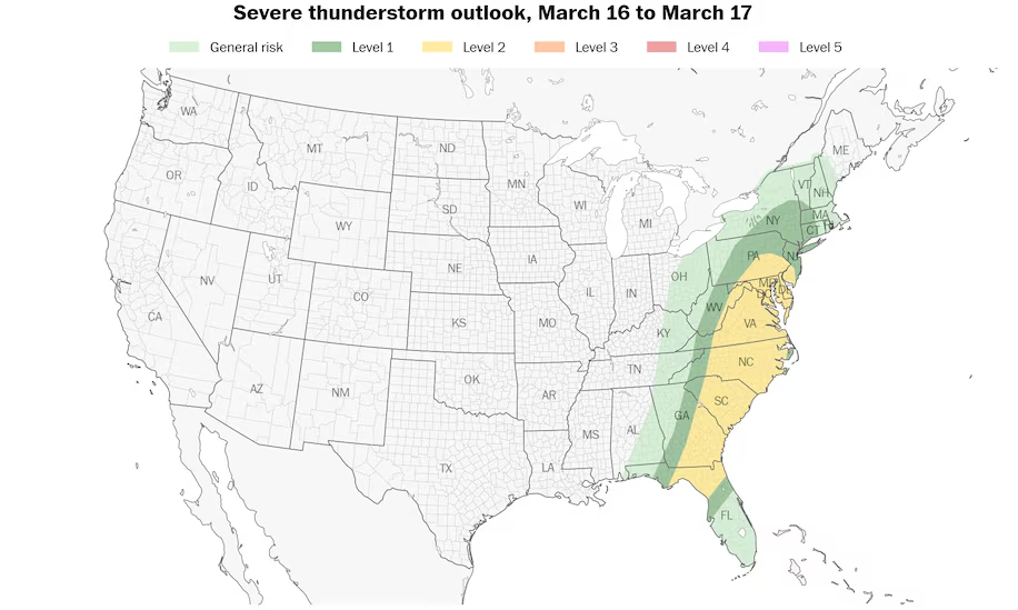
A level 2 out of 5 (slight) risk for severe thunderstorms covers several states along the East Coast on Sunday. (Ben Noll/Data source: NOAA/SPC)
A slight (Level 2 out of 5) risk of severe weather covers areas from Philadelphia to Jacksonville, Florida, and includes Washington, Baltimore and Richmond, as well as Raleigh and Wilmington in North Carolina.
There could be additional thunderstorms along the cold front as it pushes east. With strong jet stream winds aloft, storms could produce gusts of up to 60 mph at the surface. An isolated tornado is possible.
The big picture
It’s somewhat rare to have two weather systems produce two different tornado outbreaks on back-to-back days. This plot depicts where weather models are simulating rotating updrafts, which could produce tornadoes:
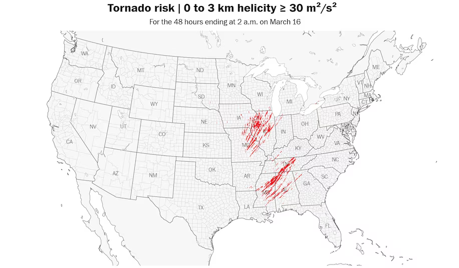
These helicity swaths indicate areas that have a heightened risk for tornadoes. Helicity is a measure of the potential for rotating updrafts in the atmosphere. (Ben Noll/Data source: NOAA)
Extreme fire weather risk
Eastern New Mexico, northern Texas, much of Oklahoma, southeastern Kansas and southwestern Missouri also face an extremely critical fire weather risk Friday — the highest warning level.
The fire risk will build during Friday morning as winds strengthen to tropical storm-force levels.
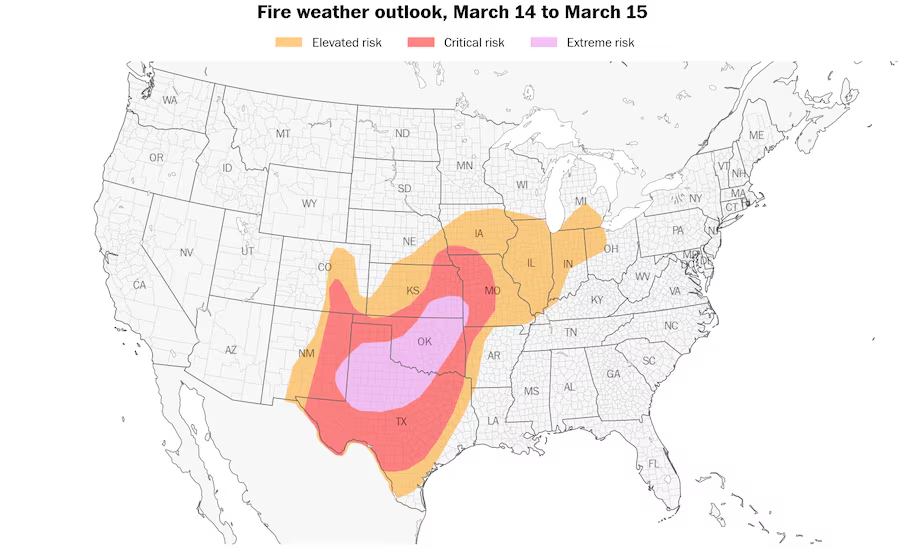
An extreme fire weather risk covers parts of eastern New Mexico, Texas, Oklahoma, southeastern Kansas and southwestern Missouri on Friday. (Ben Noll/Data source: NOAA/SPC)
The Storm Prediction Center is warning that “a wildfire outbreak appears likely on Friday” and that the combination of extremely low humidity, abundant fire fuel and extremely strong gusts of 50 to 80 mph will drive a “high-end fire weather threat.”
More than 6.5 million people live in the extreme risk area which includes cities such as Oklahoma City, Tulsa, Wichita, and Lubbock and Amarillo, Texas.
A critical risk (level 2 out of 3) covers nearly 19 million additional people across nine states. Cities included are San Antonio, Dallas, Fort Worth, Austin and Kansas City, Missouri.
Local meteorologists are warning that “any fire can get out of control very fast” and advising people not to discard cigarettes on the ground, to avoid dragging tow chains on the ground, to not drive on park on tall grass, to respect burn bans and to avoid lighting outdoor fires.

By Matthew Cappucci Matthew Cappucci is a meteorologist for Capital Weather Gang. He earned a B.A. in atmospheric sciences from Harvard University in 2019, and has contributed to The Washington Post since he was 18. He is an avid storm chaser and adventurer, and covers all types of weather, climate science, and astronomy.follow on X@MatthewCappucci

By Ben Noll Ben Noll is a meteorologist with a passion for communicating the ‘why behind the weather,’ extreme events and climate trends. He has extensive experience working with meteorological data and creating weather graphics on a supercomputer, developing meteorological services in the Pacific Islands, and short, medium and long-range weather prediction. Follow on X @BenNollWeather
Much more:
Here are more “ETs” recorded from around the planet the last couple of days, their consequences, and some extreme temperature outlooks, as well as any extreme precipitation reports:
Here is more new February 2025 and Winter 2024/25 climatology (summer for Southern Hemisphere):
Here is More Climate News from Friday:
(As usual, this will be a fluid post in which more information gets added during the day as it crosses my radar, crediting all who have put it on-line. Items will be archived on this site for posterity. In most instances click on the pictures of each tweet to see each article. The most noteworthy items will be listed first.)