Tuesday Evening Updates…
Dear diary. The heat is on, says the Glen Frey song, in the nation’s heartland. The area of heat advisories and excessive heat warnings have expanded from South Dakota into Kentucky:

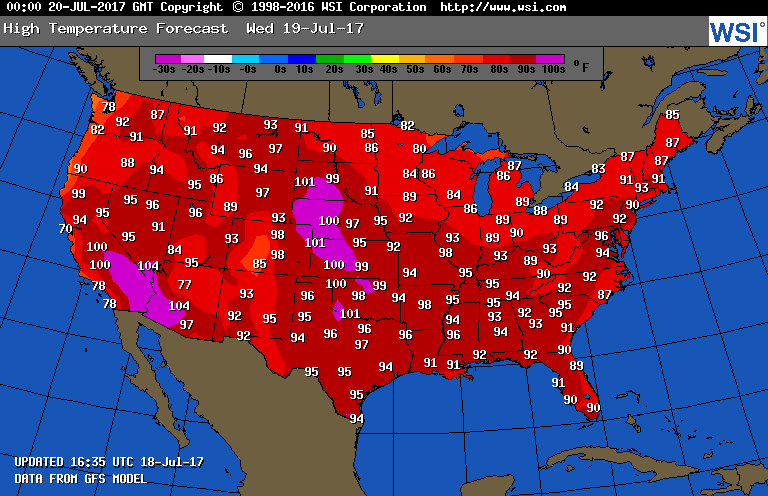
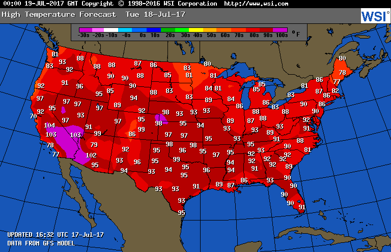
I would expect advisories will go up for the middle and late week across much of the Northeast and Middle Atlantic. Tomorrow temperatures will be in the 90’s to low 100’s in the Plains… below record levels but dangerous, nonetheless. Only the northern Great Lakes and New England will be spared from the mid-summer heat east of the Rockies:
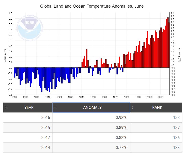
Let me touch on global averages for June. The last four Junes were the record warmest since record keeping began in 1880 using NOAA data:
Due to carbon pollution it’s no wonder that U.S. summers have been skewed recently towards record heat. NOAA announced that the first half of 2017 was the planet’s second -warmest on record, trailing only the first half of 2016.
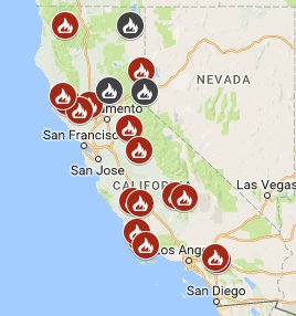
We are still dealing with the aftermath of the last couple of strong synoptic heat domes. Despite temperatures moderating a few degrees after the southwestern heat wave, California continues to smolder. As of today according to Eric Holthaus there are twenty major fires burning across California, which is 249% above average. One never stops getting surprised with weather and climate. After a very wet winter and spring I would have thought that wildfires would not have been much of problem this year. Extreme, record heat trumped any beneficial moisture across California this season:
This visible satellite image showing the massive smoke plume from the Detwiler Fire in Mariposa County from Rob Ellington underlines how fast a good situation can go down the tubes due to a carbon pollution related heat wave:

In this blaze alone 19,600 acres have been burned. As of this writing only 5% of this conflagration has been contained.
Here are today’s maxes:
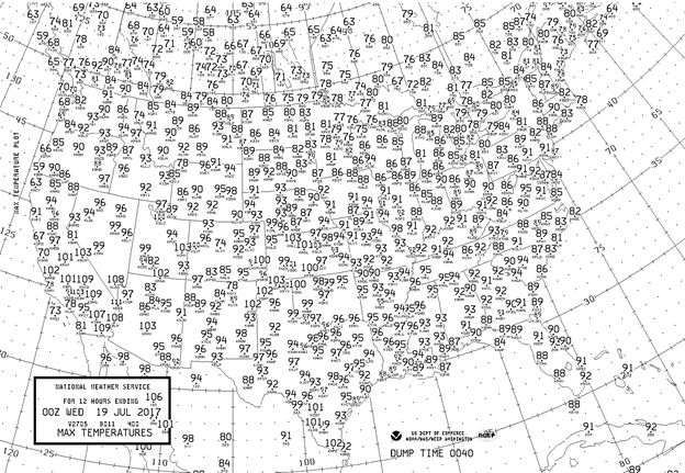
There finally was some relief for North Dakota and Montana. A good chunk of the nation was sweltering in 90+ temps. Kansas was the hot state east of the Rockies where many stations got above 100F.
I’ll be updating this post as any newsworthy items come to the fore.
The Climate Guy
Tuesday July 18th…
Dear diary. Good news! Our 4th heat wave of the season will break by next week in the East due to 1) an upper level low developing off the Southeast Coast then retrograding (or moving west) towards the Gulf Coast 2) a refreshing Canadian front moving into the Great Lakes and Northeast.
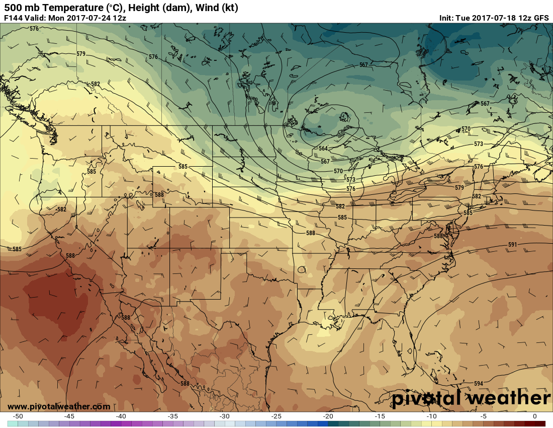
The zenith of the heat wave should be on Friday after the heat dome maxes out in the middle Mississippi Valley at about 598 on Wednesday. Here we see the heat dome as demarcated by the 594 decameter circle on Thursday:

Note the upper level low near the South Carolina coast. The GFS a couple of days ago did not forecast this feature to develop, but instead built the upper ridge unto the Southeast. Should the ridge build into the Southeast and persist heat would have built to near record levels by next week. The low should filter relatively cooler Atlantic and Gulf air into interior portions of the Southeast this weekend. Regardless, some locations, such as Atlanta by Thursday and Friday should see their hottest maxes of the season, so far. Atlanta has seen a relatively mild summer with their highest max being 92. Friday is still slated to be a very hot day east of the Rockies except for the Great Lakes and New England:

Looks like summer 2017 is one of the predominant western ridge. By Monday the upper air pattern will have reverted to what we have been seeing for most of this season…a trough in the East, and that pesky ridge building again in the West:
I’ll be adding to this post with updates later today.
To see all 2017 Heat Diary entries click:
https://guyonclimate.com/category/heatdiary2017/
The Climate Guy
Monday evening updates…
Dear diary. Here are tomorrow’s forecast maxes from the GFS:
There will be widespread 90s across the Plains and that expected warming trend in the Southeast. Montana and the Dakotas should see some relief in the wake of a front. Northern California will see the coolest conditions in weeks. From Rob Ellington, Redding, CA’s streak om maxes at or above 100F should end at 19 on Tuesday:

I’m reminded upon seeing heat advisories in the Midwest about humidity and the Heat Index. Although record highs are not expected in the shaded areas across the central Plains and Illinois, dangerous heat will occur on Tuesday mainly due to high dew points:

As a matter of fact, the density of corn fields across the Midwest raises dew points by transpiring added moisture into the air:
 Here are Monday’s maxes:

Heat is increasing in the western Plains. The GFS guidance was not high enough in South Dakota, western Oklahoma, and portions of Texas.
The Climate Guy
Monday July 17th…
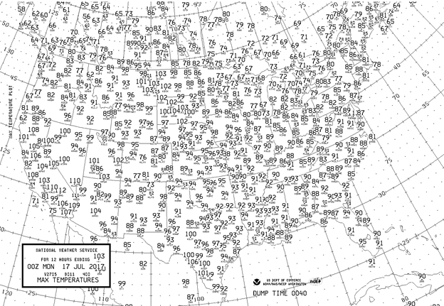
Dear diary. I’d like to start off with presenting yesterday’s maxes to compare temperatures before the start of a 4th heat wave that I arbitrarily stated would begin today:
In a real sense prior heat waves never ended in California, the Dakotas and Montana. In the muddled world of meteorology there can be a lot of overlap with events.
Let’s take stock in what happened across the Southwest during the last two most historic heat waves of the season. From MDA Weather Services: The first half of summer was hottest on record at Phoenix, Las Vegas, Salt Lake City, Reno, Tucson, and 6th hottest in Washington D.C.

Despite the prior Southwest heat wave being historic, it failed to produce a relatively substantial number of reports in the NCEI database during July (substantial being over 1,000 reports). Most of the reports in July, so far, occurred over the Southwest association with this season’s third heatwave. Am showing this chart to compare the numbers during the coming forth heatwave with prior totals. As a reminder, these are all reports in the NCEI database of daily records including ties:

The heat this week an association with the 4th heat wave in the Plains and East might not be torrid enough to substantially add to the total on my chart during July. We will see.
Certainly it will be dangerously hot. Here are the two meter GFS forecasts, which do reflect within a few degrees what could be happening at the surface on Friday the 21st:

On the bright side, this morning’s model run is squelching the heat wave faster after Friday the 21st than prior model runs, and the heat this week does not look historically hot.
I’ll be adding to this post with updates later today.
To see all 2017 Heat Diary entries click:
https://guyonclimate.com/category/heatdiary2017/
The Climate Guy