Thursday Evening Updates…
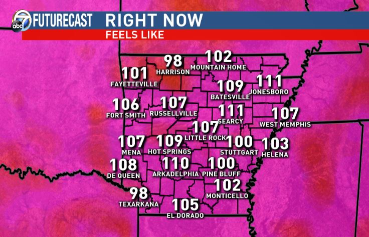
Dear diary. Yes, as Glen Frey would sing, the heat is on in late July, and it’s really on in Arkansas considering the Heat Index. Check out these numbers from this afternoon from Barry Brandt:
Here are Thursday’s highs:
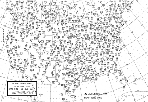
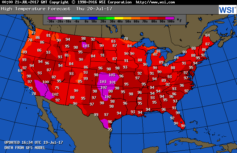
Widespread readings at or above 100F were common in the Plains. It got up to 98F at Washington D.C., which was the highest max there so far this season.
The Climate Guy
Thursday July 20th…
Dear diary. Our 4th heat wave will be at its zenith today and on Friday across the Southeast and much of the Eastern Seaboard. Dangerous heat will last in the Plains through this weekend. Let’s start my usual graphics parade by showing how much heat advisories have expanded in the nations mid-section and along the East Coast:
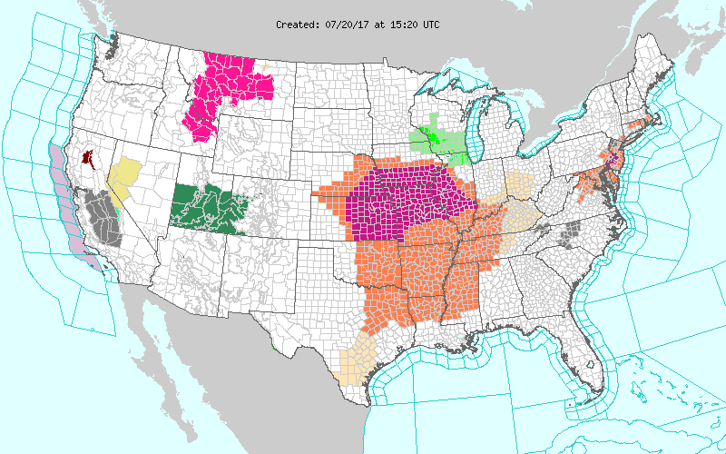
By no means is this area the largest I have seen in past years, and this heat wave will probably produce a scant number of records, but people should take precautions and be aware of their bodies symptoms in association with the heat.
Tomorrow there will be more of the same. Many locations in the Plains will crack the century mark. Megalopolis locations, such as Washington D.C., will flirt with 100F.

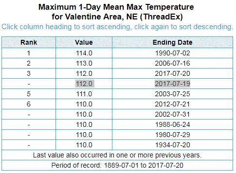
On the other hand, I’m beginning to get some indications that this heat wave will be producing some records. Boulder, CO tied a record and got to 100F for the first time since 2012 yesterday. Valentine, NE got up to 112F, which was their third highest all-time reading.
This was cute:😍

Salt Lake City, UT has had a particularly hot summer. Take a look at their streak of nights not getting 70 (from MDA Weather Services):

Salt Lake’s hot streak ranks #1.
I’ll be adding to this post as heat wave related news comes in during the day.
The Climate Guy
Wednesday Evening Updates…
Here are today’s maxes:

Once more the GFS temp guidance under forecast the maxes in the Plains. Mixes between 100-107F were coming from Denver eastward through South Dakota and much of the central Plains. Dangerous heat has developed along the Eastern Seaboard with all if the Megalopolis cities reaching at least 93F.
Before closing tonight I’m going to leave you with a chart from Brian Brettschneider indicating where all-time or near all-time records have occurred this year. As one might expect, the hottest conditions have been in the West, and particularly the Southwest, so far during the summer of 2017.

Wednesday July 19th…
Dear diary. The 4th heat wave of the season is well underway. I’m still not anticipating many records from the event this week, but I’m beginning to see signs that this heat wave may not end next week across the Plains or portions of the South. Due to carbon pollution the chances for above average temperatures are high in this day and age, and that is certainly the case across most of the country this week.
Looking at GFS two meter temps for today, I would expect some high max numbers on the national actual high chart I present nearly everyday:

Tomorrow we should see some of the warmest readings, so far, this summer in the Southeast:
So why might this 4th heat wave continue into next week? My first rule of thumb is to not look at models past about 240 hours, so the middle of next week certainly falls inside that timeframe. Here is the operational GFS 500 Mb chart from Wednesday the 26th:
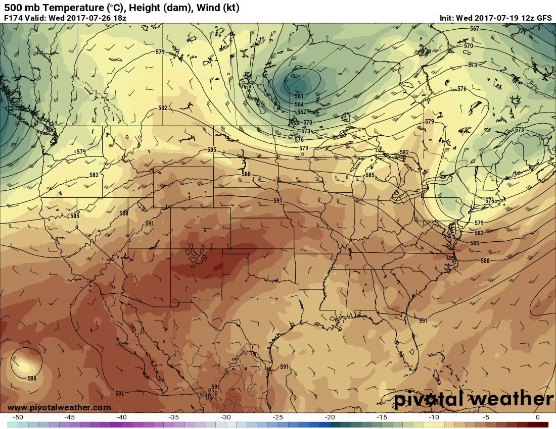
By this point a Canadian system has put the kibosh on the heat in the Northeast, but notice a huge area of 588 decameter + heights left across the West, Plains and Southeast. During the summer usually heights that high spell hot temperatures at the surface. Here is the corresponding two meter temp chart valid on Wednesday the 26th:

Dangerous heat will continue mostly in the Plains, but values should be below record levels.
I’ll be adding to this post with updates later today.
To see all 2017 Heat Diary entries click:
https://guyonclimate.com/category/heatdiary2017/
The Climate Guy