Sunday September 3rd…
Dear diary. After seeing a couple more model runs since posting my long diatribe on the chances for Irma making a U.S. landfall yesterday, my forecast has not changed. I’m giving Irma a 80% chance of making a U.S. strike somewhere along the East Coast the following week. Now we can start pinning down a potential timeframe (from 9/10-9/13) for any landfall. There remains about a 20% chance for Irma to somehow miss Cape Hatteras to the east of the U.S. I’m making my forecasts this early to give any people reading this post as much heads up warning as scientifically possible given the state of meteorological models.
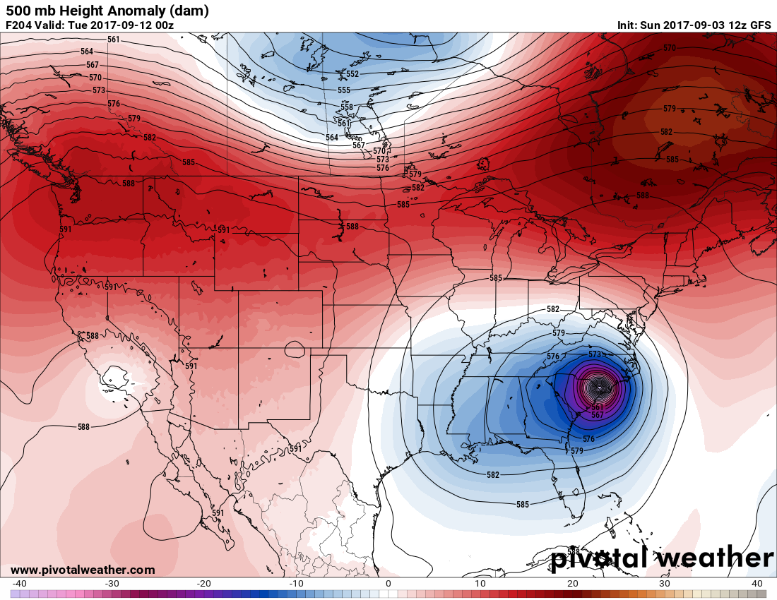
The operational GFS and its ensemble members have stayed consistent since last night. Usually the most consistent model is the one that verifies. Unfortunately the GFS has been consistently been moving Irma into either the Middle Atlantic or Carolina’s:
Here are the GFS ensembles from this morning:
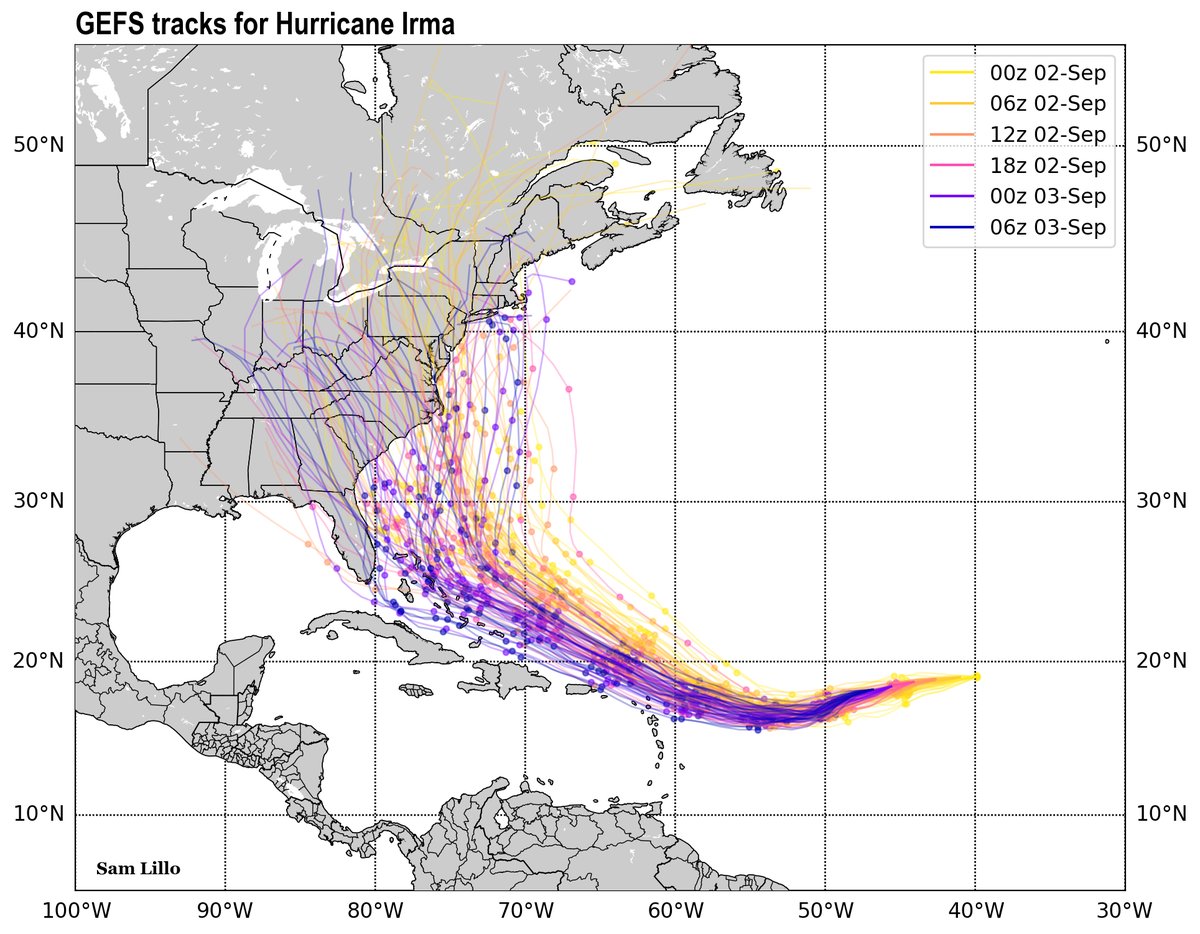
Unfortunately, the GFS ensembles have shifted Irma’s track west brining a higher threat to the Greater Antilles.
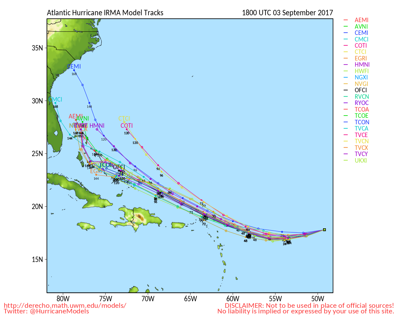
Here is a spaghetti plot of the hurricane models that are in fair agreement taking Irma into the Bahamas:
There remains some hope for a U.S. miss coming from the most reliable model, the European. This mornings operational model looked very odd though, nearly slamming south Florida then moving Irma due north, then northeast out to sea:
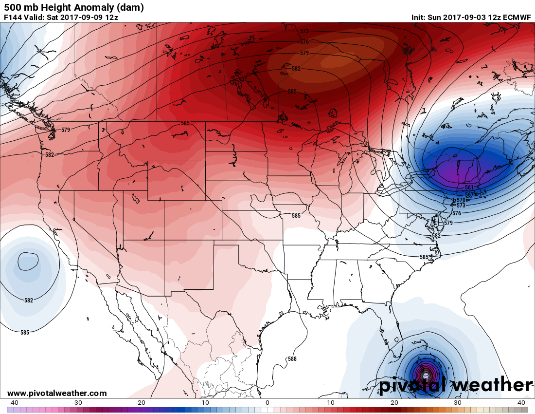
If Irma gets into the southern Bahamas, as is forecast by the EURO, with the East Coast trough lifting and moving East, the system is more likely to move through Florida into the Gulf then lift away from the U.S.
Now let’s see what has been happening with heat wave #8. It’s certainly historic given that all-time records are being set in the San Francisco Bay area. Quoting the Weather Underground Category 6 blog:
“The steamy, fiery summer of 2017 hit a new crescendo this weekend across the U.S. West, which is getting its hottest Labor Day weekend on record in many locations—and in some spots, the hottest weather ever observed. Overall, “this is the greatest statewide heat wave ever recorded in California,” proclaimed WU weather historian Christopher Burt on Saturday night. Burt based his conclusion not only on the heat’s intensity but on its widespread nature well beyond California’s usual scorching locations. Even an escape to the cool Pacific shore was pretty much futile, as easterly downslope winds funneled scorching air from the interior into coastal sections that are normally mild and sometimes chilly even in midsummer.”
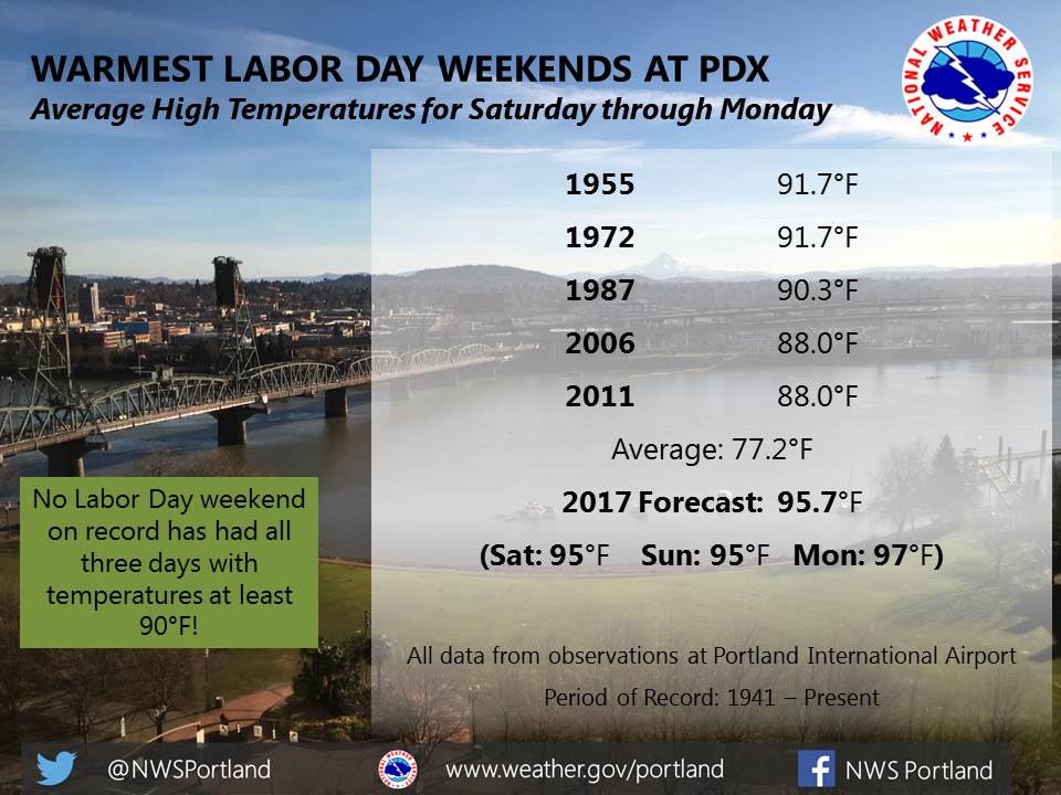
Here are some forecasts from Oregon:

Here are some more records set yesterday 9/2:
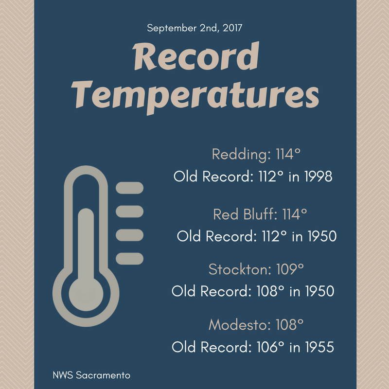
Sunday Evening Updates…
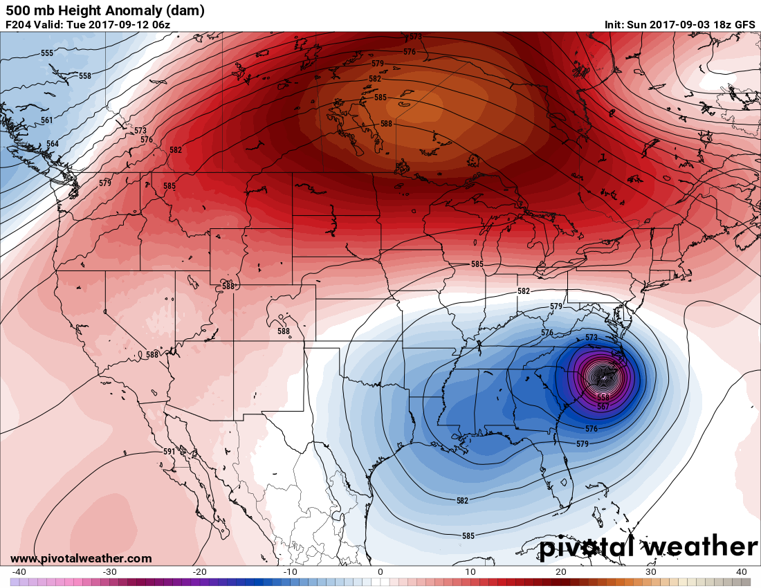
The operational 18Z GFS was very consistent with the 12Z run, just a tad slower and further east:
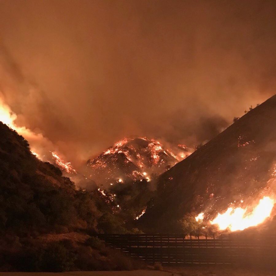
Here’s a quote, “Holy smokes! This is Burbank. What do they say about the largest flood followed by the largest fire ever?” (This evening from Mikel Jollet @Mikel_Jollet):
It was a hot day in Idaho. Stanley at 96F and Challis at 93F set new records for September, and Pocatello tied its September mark at 97F.
I’ll be adding more relevant information as the day progresses.
The Climate Guy
Saturday September 2nd…
Dear diary. Let’s cut to the chase. Meteorologically, it appears that there is only a tiny window for Irma to avoid making a U.S. landfall. Ensemble members of both the European and GFS models point to a landfall anywhere from Miami to Boston with the most likely areas being from the Carolinas to the Middle Atlantic. On top of this it is likely that Irma will slam into the coast as a category 3 hurricane or worse. Today I will go into the reasons for these assessments. Also remember my golden rule, I won’t use garbage model data more than 240 hours out. Now that model data in association with a potential Irma landfall is within the 240 hour parameter, I’m willing to point out key features.
The operational GFS model this morning has Irma moving into the Middle Atlantic as a major hurricane:
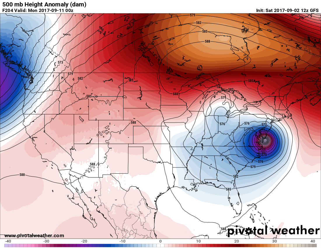
Last night the more reliable 00Z European model slammed Irma into Charleston:
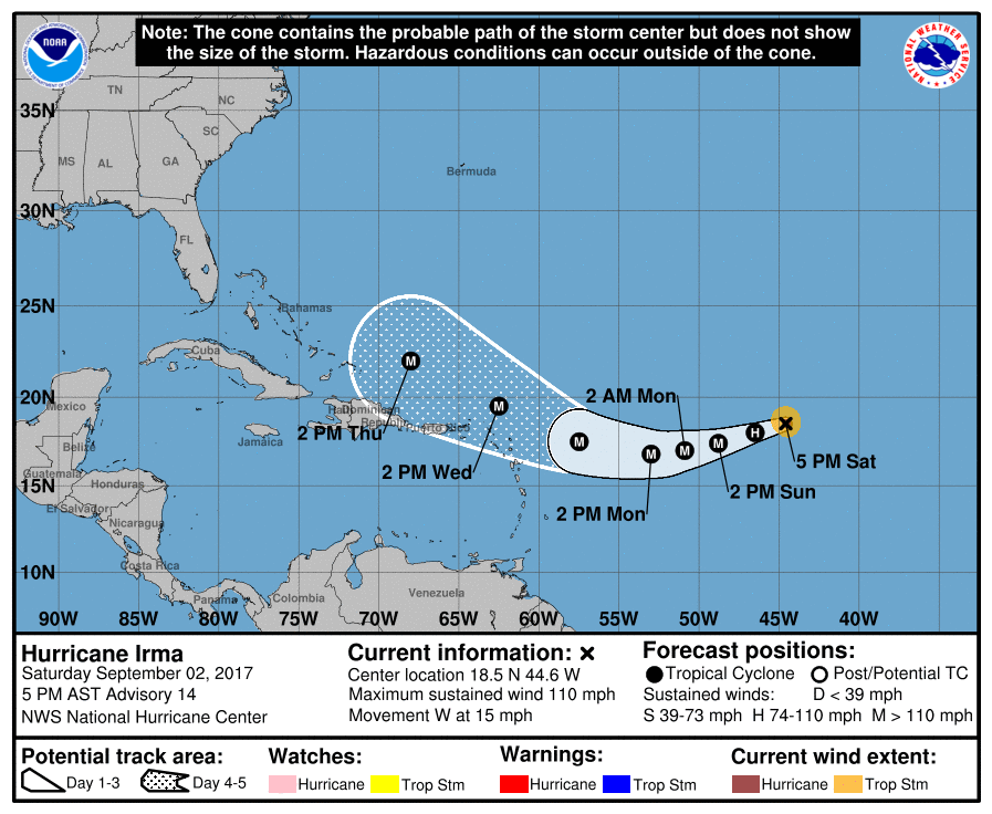
Here is NHC’s latest five day track and cone:
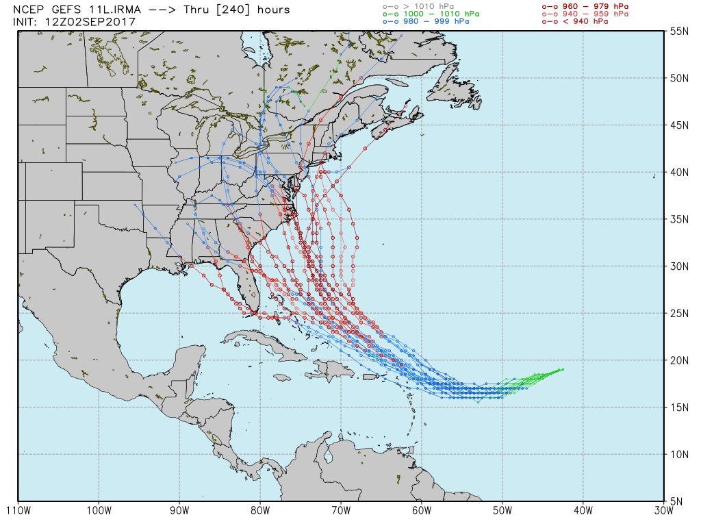
Currently all GFS ensemble members save one has a U.S. landfall:
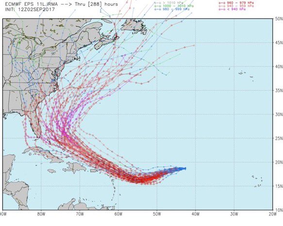
Here is that one ray of hope. The 12Z SAT EURO ensemble members are about split with half moving Irma offshore and half on. Of the two models, as mentioned often, the European model is the most reliable:
More often than not a Cape Verde system this time of the year that misses the Leeward Islands to the north will recurve from the U.S. out to sea. Why most likely will Irma hit the U.S. mainland?
There are two main factors. A pattern change will be underway across North America next week, and climate change factors are involved. First, part of the huge heat dome that produced all-time record heat in San Francisco yesterday will move northward into Canada creating a “block” that will more than likely prevent Irma from recurving east away from the U.S. Here are three successive Penn State charts showing this transition:
(Chart 1)
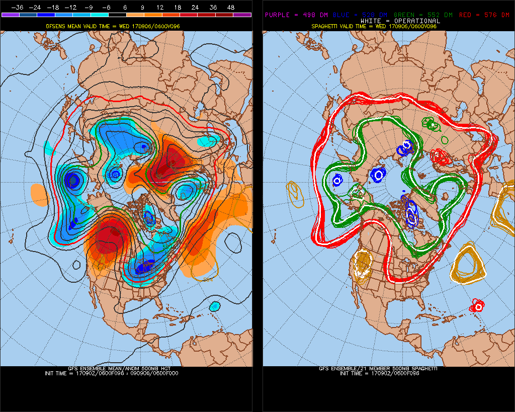
On chart 1 we see a deep trough digging into the central U.S. This system is about the only hope for a U.S. miss. The trough should be strong enough to lift Irma from the Bahamas, but unfortunately probably won’t turn Irma to the northeast.
(Chart 2)

The second main factor for a U.S. landfall is seen in chart 2. If a closed low morphs out of the strong trough somewhere west of the Appalachians watch out. If this happens steering flow would be due north or north northeast moving Irma into the Atlantic Seaboard area. If a closed low were to develop in the Northeast Irma would be steered out to sea. One of my former TWC colleagues, Stu Ostro, continuously pointed out that closed lows were developing more frequently due to climate change when warm positive anomalies developed at high latitudes. Certainly this might be the case next week across Canada.
(Chart 3)
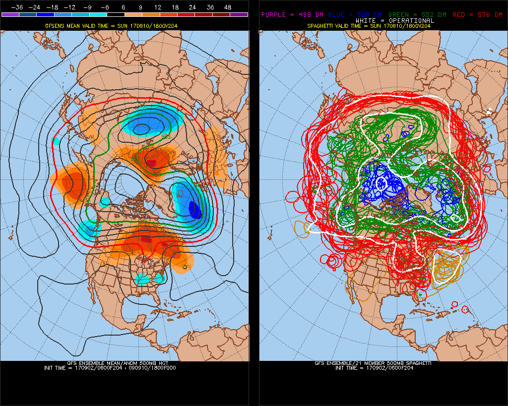
On chart 3 we see what I contend is a carbon pollution pumped up ridge over most of Canada. If the thing builds as forecast on chart 3 in eastern Canada there will be no escape for some portion of the eastern U.S.
Just about every model I’ve seen has Irma maintaining category 3 status or better up to the latitude of New York City. Further north, if the system makes landfall in New England the system could be weaker due to shear and lower sea surface temperatures.
Speaking of sea surface temperatures Irma has a lot of climate change ramped up sea surface anomalies to work with over whatever path it takes:
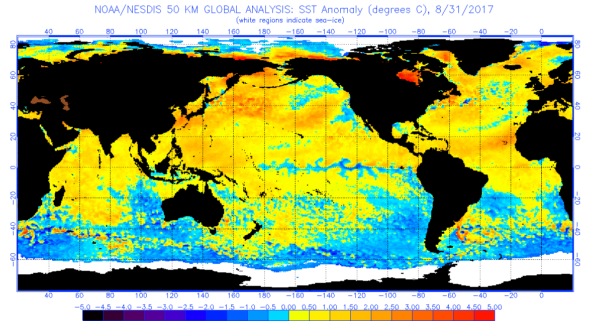
I can’t recall ever seeing global sea surface temperatures that are as high as depicted on this current chart.
So what would the probability that I am giving for a U.S. landfall of Irma?
80%
I’ll be adjusting my forecast for both a U.S. landfall and any location, if course, as Irma slowly works its way through the Atlantic.
Saturday Evening Updates:
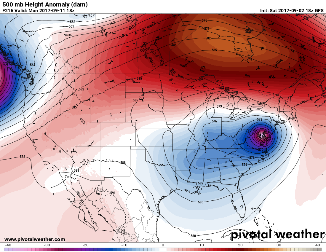
This afternoons 18Z GFS operational model had another Mid-Atlantic landfall for Irma:
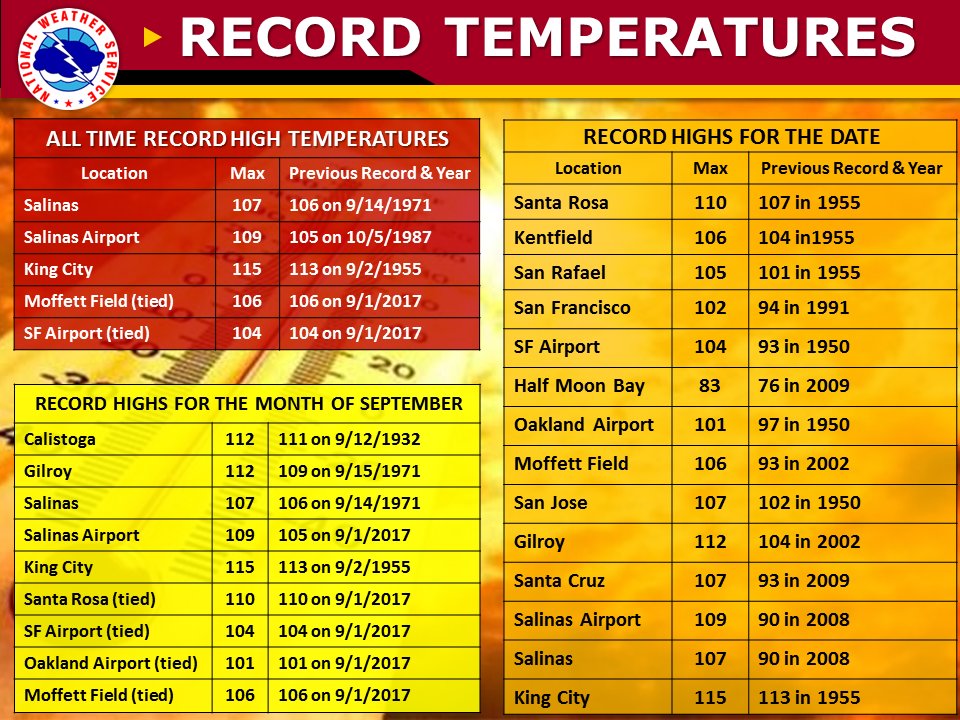
It was extraordinary hot again from northern California into the Pacific Northwest today. Here are records set for 9/2/17:
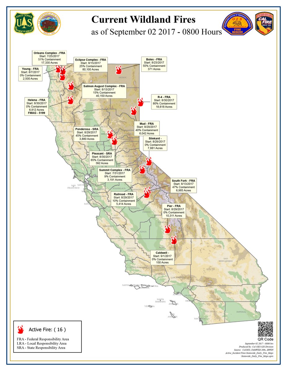
Fires are becoming a bigger problem in the dry, hot state of California. This is a current map of fire locations in that state:
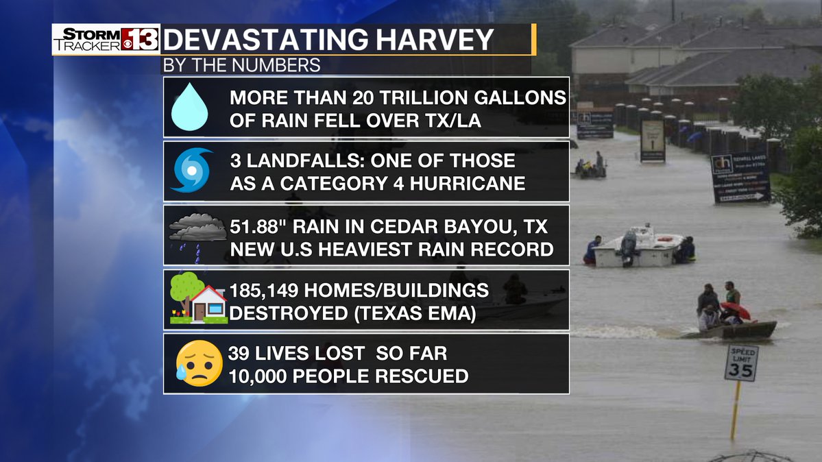
 We can never forget about Harvey. I like this graphic from Erik Taylor (@WeatherErik)), but I’m saddened to see these statistics:
I’ll be adding more relevant information to this post later today.
The Climate Guy
Friday September 1st…
Dear diary. We are finally in September. The U.S. didn’t fair so well during boreal summer, mainly due to Harvey and the western heat waves. The situation actually could have been so much worse if we had seen another dreaded 10-1 or better June, July or August ratio of daily record highs to lows. Starting in 2015 as highlighted in bold on my record count chart, months of 10-1 ratios are becoming more common:

The last month with a ratio of 10-1 or greater was February 2017.
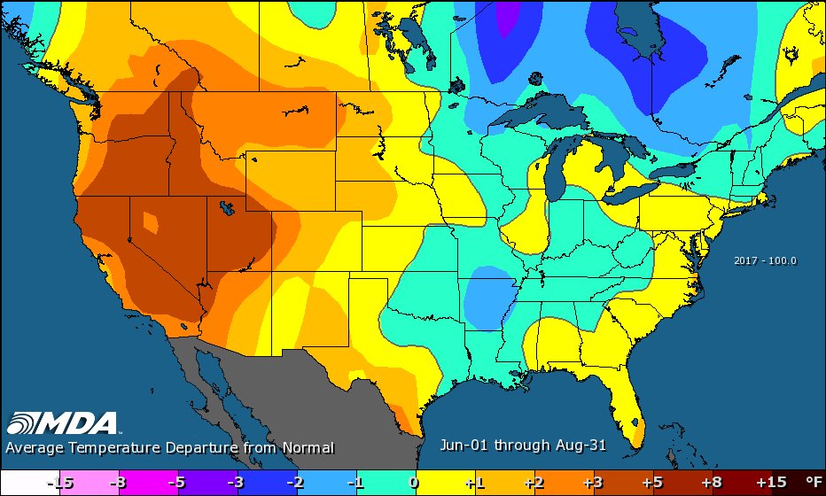
From MDA Weather Services here is how the summer 2017 climatology is beginning to stack up:
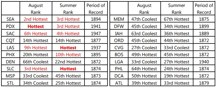
Nationally, notice that there were cooler than average areas during boreal summer, but hotter than average areas were very hot…a sign of climate change:
There are plenty of articles and blog posts dealing with the aftermath of Harvey, which I have no doubt will be the costliest natural disaster in U.S. history. Before moving on to what I specialize in, reporting record heat, I’ll plug another of Bob Henson’s latest great blogs on Harvey:
https://www.wunderground.com/cat6/no-longer-tropical-storm-harvey-leaves-texas-reeling
As mentioned in Bob’s blog we should all be thanking the many forecasters, and hurricane researchers who have been working tirelessly to warn people and public officials days in advance of Harvey’s arrival on the Texas Coast. It will take literally years for south-central and southeast Texas to recover, but early warnings certainly limited death tolls. One more huge point I can’t stress enough: Any smart rebuilding will need to take into account climate change.
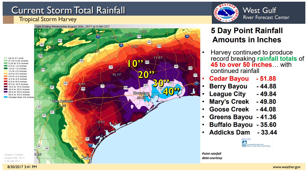
Here is a very clear, recently updated NWS graphic on rainfall tallies in association with Harvey:
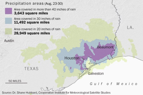
This chart is just astounding:
Here’s a guide on when all this water will recede:

One item not stressed much is the typical summer heat with maxes well into the 90’s building over already highly stressed areas in Texas recovering from Harvey. Air conditioning may not be functioning in many locations, so people will need to take shelter just from the heat alone. Mold also grows fast in a hot, damp environment.
What I’ll stress and go into detail today in this post during the weekend is the current western heat wave, or by my count heat wave #8, for the U.S. this season. Here is this morning’s take in the heatwave by the L.A. Times with a link to Harvey:
http://www.latimes.com/local/lanow/la-me-lightning-weather-extreme-heat-20170901-story.html
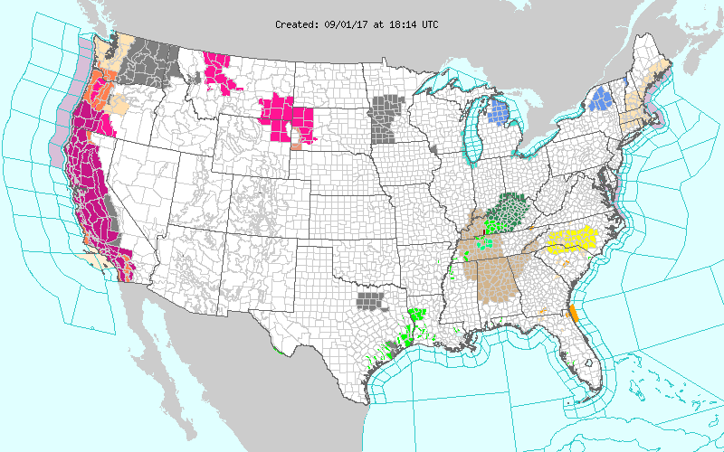
There are excessive heat warnings posted for much of California and some parts of Oregon today through this weekend:
I’ll be looking for a lot of record reports to come out of the San Francisco Bay area later today.
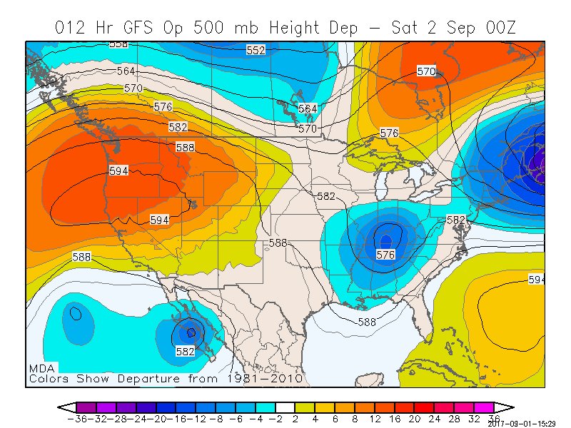
According to MDA Weather Services the current forecast for Sacramento is 111F for today and 110F for Saturday. The monthly record for September at Sacramento is 108F. Here is how the heat dome in the West will be stacking up the next couple of days:
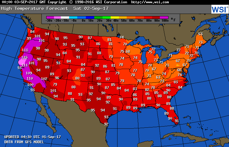
 Usually locations within a few miles from the western shoreline offer some relief from intense heat. On Saturday there won’t be much relief, even at the beaches in the West:
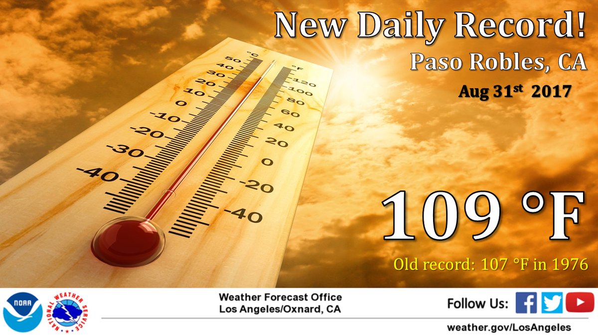
Here’s another record report from the Los Angeles area from yesterday:
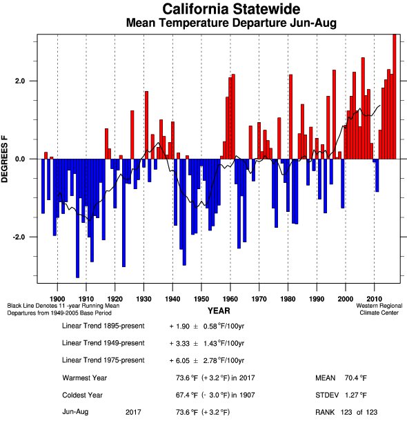
Wow but no surprise! Despite seeing a cool, wet winter and spring, California just had its hottest summer on record, and by a considerable margin. (Image from Daniel West):
I don’t want to give false hope in association with Irma since climatology is changing due to carbon pollution but, according to MDA Weather Services, no tropical system within two hundred miles of where Irma was located about 8 hours ago, except for the 1893 unnamed hurricane, has made a U.S. landfall:
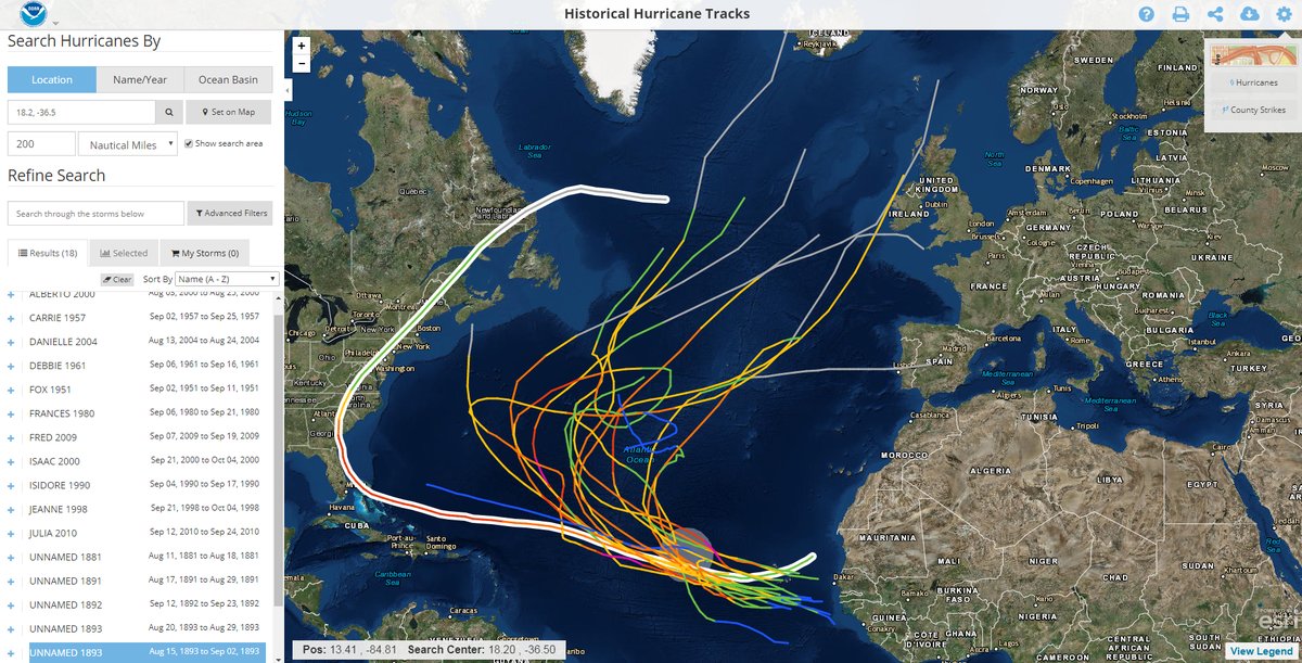
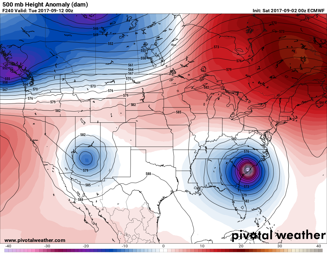
That being stated here is the latest and greatest model (The 12Z Euro from Friday) forecasting Irma to be way too close to the U.S. to avoid a landfall:
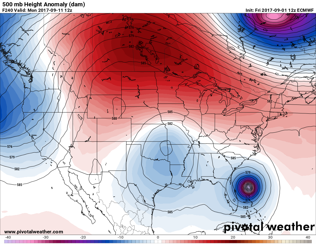
Note the tremendous area of positive anomalies (in red) across Canada. Those anomalies could be key blocking Irma from recurving away from the U.S.
Friday Evening Updates…
Dear diary. Ouch! Downtown San Francisco hit an all-time record at 106F today. The hottest reading at the SFO station was 103 set in 9/14 in 1971, and that station also hit an all-time record at 104F today.(source Threadex). Just wow:
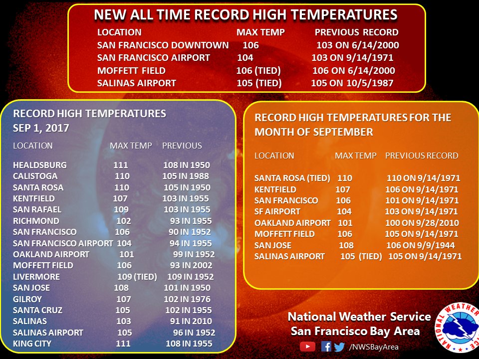
Here’s a toasty forecast for Portland OR:
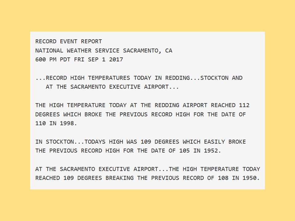
Here are some records set today from the Sacramento Valley:
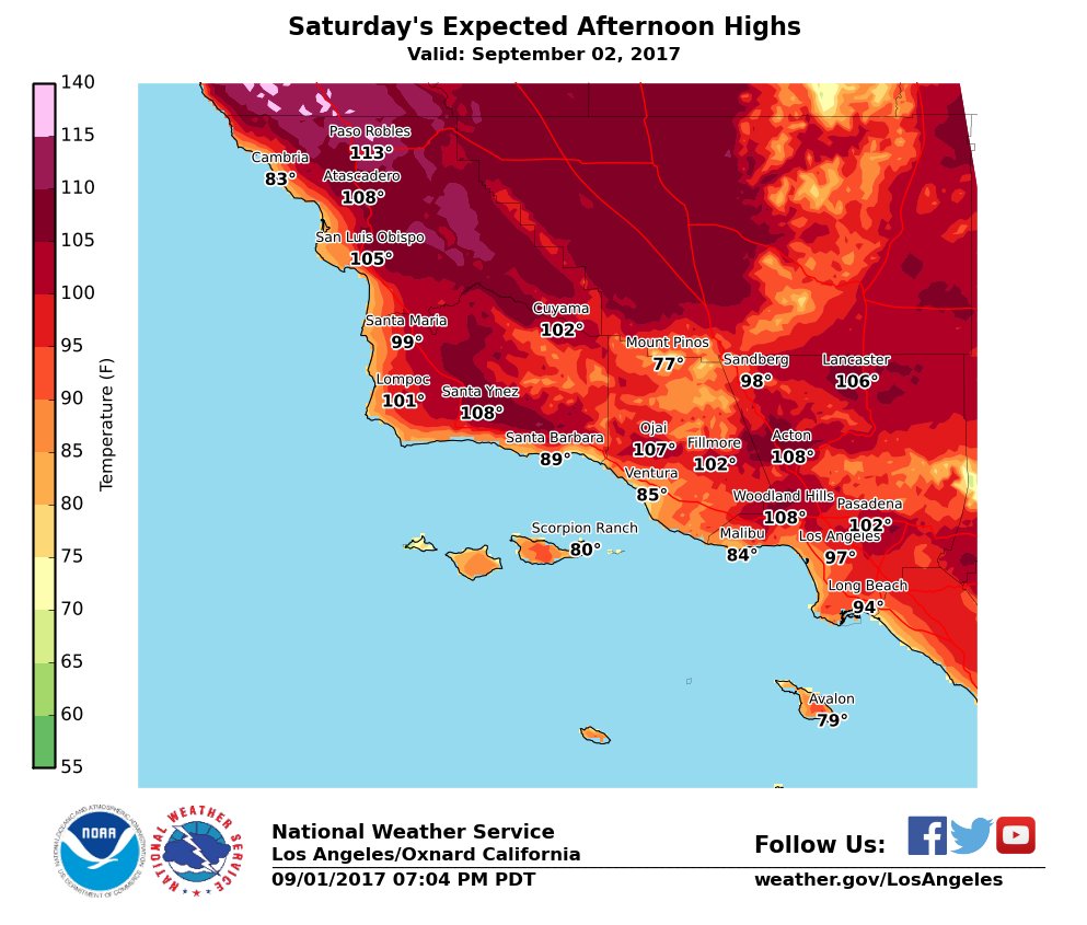
And finally for tonight here are some toasty forecast temps in and around Los Angeles for Saturday:
To see all 2017 Heat Diary entries click:
https://guyonclimate.com/category/heatdiary2017/
The Climate Guy