Sunday December 3rd…Dear Diary. Here is today’s climate change related topic:
Novembers to Remember… Big Markers for Warming
It certainly has been warm to mild across most of the United States during November, but how does November 2017 stack up with November 2016? I remember that here in the South many days were above 80F for maxes, and it got so dry over the late summer/fall that the tragic Gatlinburg fire occurred in late November last year. Before NCEI averages get processed around 12/7 for this November let’s compare record counts of two very warm months (these counts will change slightly as the database get’s updated in time… data updated through 12/3/17):
DHMX DLMN DHMN DLMX MHMX MLMN MHMN MLMX
NOV 2017: 3639 745 3516 929 106 6 146 2
NOV 2016: 6291 136 4233 133 570 4 252 3
As warm as it has been this fall November 2016 remains king looking at record statistics. To this date NOV 2016 has the highest ratio of record daily high maxes to low minimums across the United States, currently at 46.3 to 1, than ANY month since January 1920. Average wise, November 2016 ranks 2nd warmest with the warmest November being in 1999:

Here are the rankings for November 2017, which came in as 7th warmest overall:
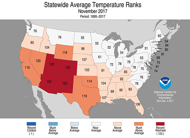
So what’s the point of comparing a couple of recent warm months? In doing so we can see that their are undeniable warm markers, which can be linked to climate change. The point is that these two Novembers were very recent. The three warmest years on record, globally, were very recent also…. from 2014-2016. We can also see that even during the warmest synoptic regimes expect to see some record cold weather somewhere in the U.S.
The synoptic pattern coming up for the eastern 2/3rds of the U.S. will certainly be colder than average after mid-week, but not unprecedented. What has aroused my alarms most, as far as a real threat to life, limb and property, is the upcoming Santa Ana pattern across Southern California. That area of the country has had a dry, hot fall. With the ridge parked over the West the dry pattern is locked in for what could be weeks. Now we see the typical pressure gradient in the West for Santa Ana winds in the wake of the front that will chill the East:
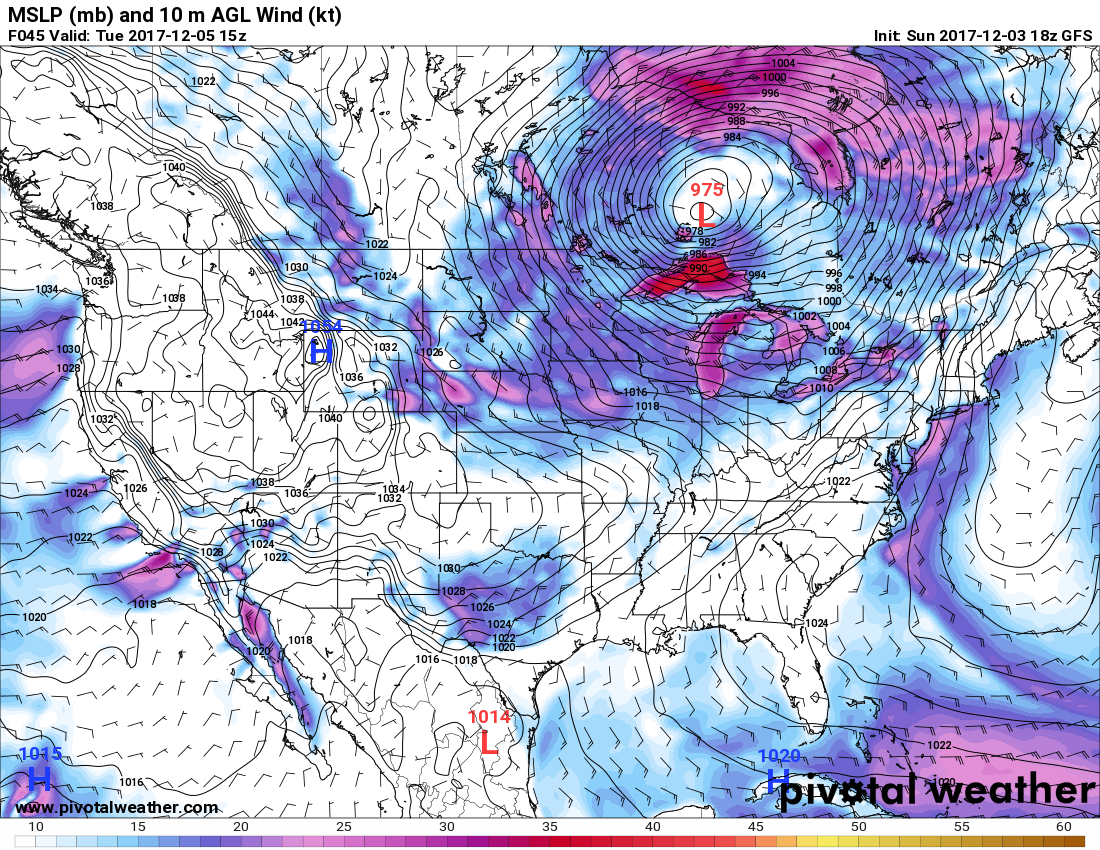
Notice how tightly packed the isobars are in Southern California on the chart. Warm winds from the northeast will start to pick up as early as tomorrow but will really be whipping around be Tuesday. This event will be very long lived, unfortunately:
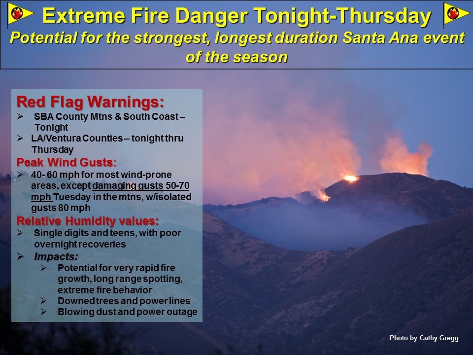
It will be interesting to see if record heat counts in the West outpace any record numbers in the East the next ten days.
The Climate Guy
Saturday December 2nd… Dear Diary. Here is today’s climate change related topic:
The Skeptical Science site has some nice graphics showing the history of climate change science, which I will now share:
https://skepticalscience.com/history-climate-science.html

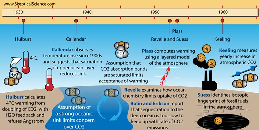
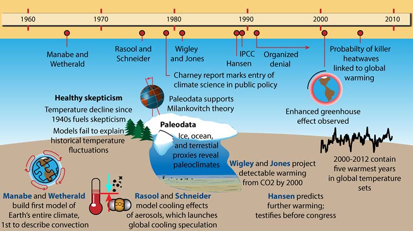
I invite all to read further both from the Skeptical Science site and others to learn what each scientist contributed to climate science presented on the graphics.
Wow! Record count statistics in association with the latest warm wave across the U.S. are becoming more impressive with each new NCEI update. Since the warm spell began in the West roughly on 11/22 we see these counts through 11/29:
2339 DHMX 1623 DHMN 26 DLMN 13 DLMX
or 3962 warm to only 39 cold records
And yep, we are still setting records in the West starting out in December:

Tucson is on track to have its warmest year:

I’ll add more to this post as relevant information crosses my radar later today.
The Climate Guy
Friday December 1st…Dear Diary. Welcome to what meteorologists call boreal winter. Before getting into that here is today’s climate change related topic:
The 2017 hurricane season in the Atlantic has been the costliest on record. Officially this deadly season’s last day was yesterday November 30th. Particularly hit hard were the northern Leeward Islands and, of course, Puerto Rico. Here are two stories that came out yesterday on regions still suffering from the blows by hurricane’s Irma and Maria.
First here is a documentary on Barbuda from the New York Times, which I highly recommend watching:
By Neil Collier, Ora Dekornfeld, and Ben Laffin 30 November 2017
(The New York Times) – “Hurricane Irma was ruthless to Barbuda. It damaged or destroyed pretty much all the buildings on the island. It left everyone vulnerable, their homes open to the sky. Walls collapsed. Windows shattered. And it opened a door for the government. The entire island was evacuated. No one was allowed to stay.”
https://www.nytimes.com/video/world/americas/100000005425833/barbuda-after-hurricane-irma.html

(Image credit: New York Times… Barbuda damage)
I am a firm believer that everything and every system in this world acts like a series of falling dominoes. If one is out of place, like the world’s climate, then others will not fall as intended. Now we are seeing the ramifications of politics and economics in association with the island’s attempted comeback from the devastating storms of 2017. Another piece shows how Puerto Rico is coping with the aftermath of Maria:
MIAMI – “The exodus of Puerto Ricans to Florida following Hurricane Maria has reached a whopping 200,000 in just over two months, obliterating initial conservative estimates that had put the number at 100,000.”
Ramped up hurricanes powered by ever increasing sea surface temperatures, such as Maria and Irma, are already creating climate change refugees putting stresses on social, economic and political systems. We’ll see more stress from the tropics in future years.
Now back to the topic of future winter temperature trends. We have been keying on December 7th as the date for the start of a very cold period for the central and eastern U.S. Models and ensembles are not deviating from this scenario:
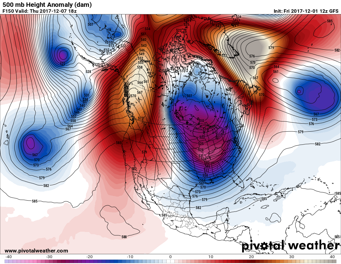
Will this pattern be “unprecedented?” For the answer to that question, I got a kick out of reading this article:
High latitude warm blocks should lead to the cold pattern in the U.S. Speaking of high latitude warmth here is a tidbit from Alaska. According to Rick Thoman @Akwx Barrow has had its warmest November in 98 years, which can be tied to sea ice loss:
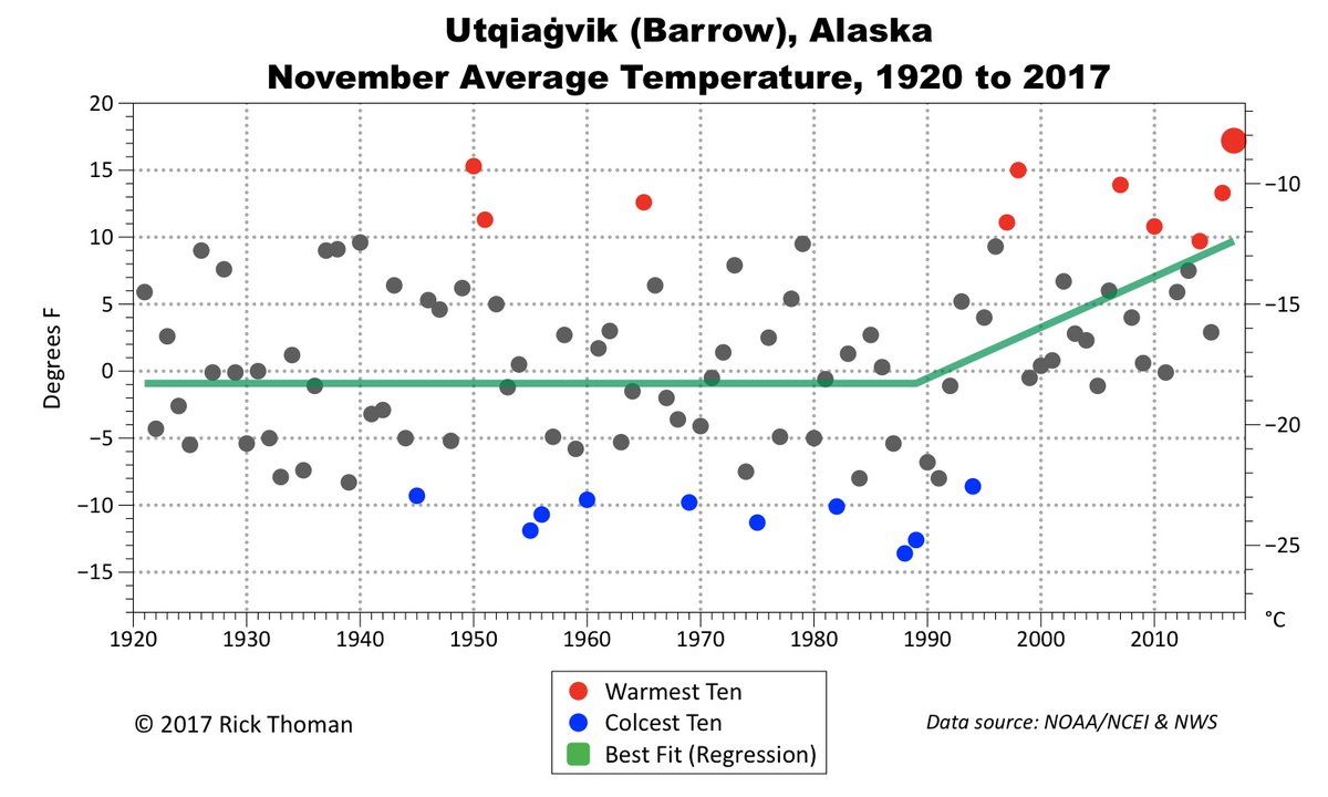
Another “cool visual” way for looking at how records are being set across the country can be found here:
http://coolwx.com/record/usamovie.week.php
Now that its the 1st of the month we are beginning to see some toasty stats come in for November. Here is one from Sam Argier:
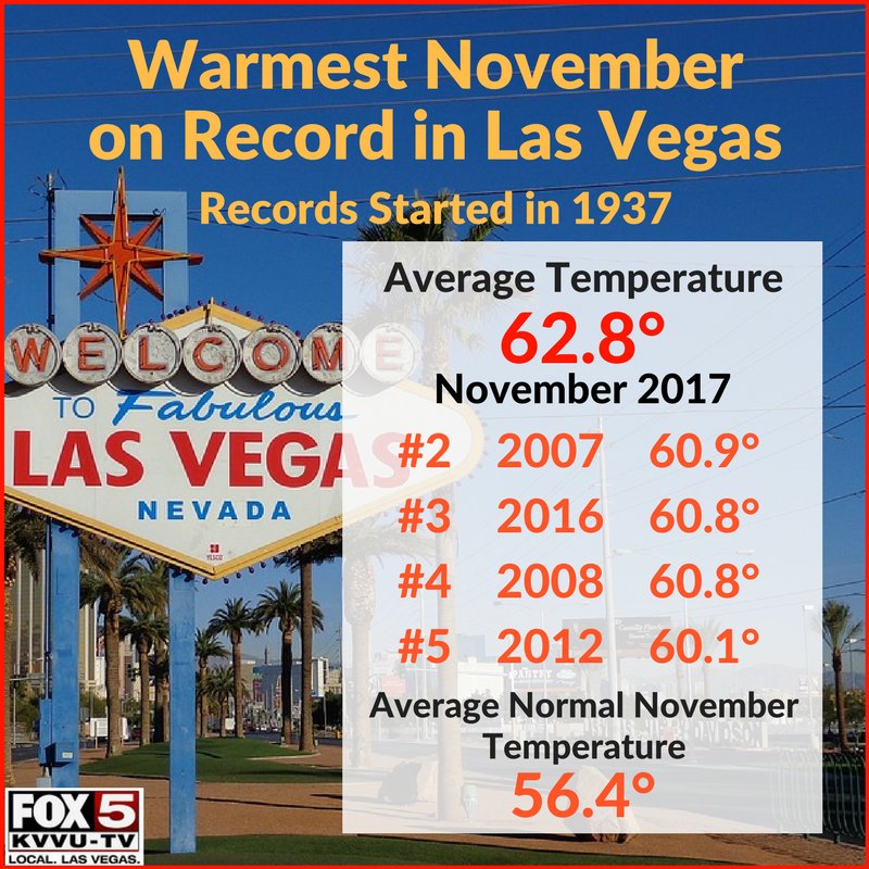
Phoenix, Tucson, Albuquerque, Reno and Salt Lake City also had their warmest Novembers on record.
Here is a handful of stats from MDA Weather Services:

And now we have new information for December. Tisk. Tisk:
The low temperature at #Tucson airport this morning was a rather warm 62°. The Dec 1st record warmest low is 54° from 1932. The all-time warmest December low is 58° on 12/7/2007. With thick cloud cover expected to continue thru midnight, these records are likely to fall. #azwx
I’ll add more relevant information to this post if it crosses my radar later today.
The Climate Guy